Tatsuno
| Tatsuno-shi た つ の 市 |
||
|---|---|---|
| Geographical location in Japan | ||
|
|
||
| Region : | Kinki | |
| Prefecture : | Hyogo | |
| Coordinates : | 34 ° 51 ' N , 134 ° 32' E | |
| Basic data | ||
| Surface: | 210.93 km² | |
| Residents : | 74,892 (October 1, 2019) |
|
| Population density : | 355 inhabitants per km² | |
| Community key : | 28229-4 | |
| Symbols | ||
| Flag / coat of arms: | ||
| Tree : | Ume | |
| Flower : | Cherry Blossom | |
| town hall | ||
| Address : |
Tatsuno City Hall 1005 - 1 , Tominaga, Tatsuno-chō Tatsuno -shi Hyogo 679-4192 |
|
| Website URL: | http://www.city.tatsuno.lg.jp/ | |
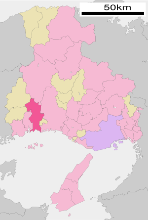
| Location Tatsunos in Hyogo Prefecture | ||
Tatsuno ( Japanese た つ の 市 , - shi ) is a city in Hyōgo prefecture in Japan .
geography
Tatsuno is east of Okayama and west of Himeji on the Seto Inland Sea .
history
Tatsuno is an old castle town . In 1334, Nitta built Yoshisada, but it soon came under the ownership of the Akamatsu, who resided there for two hundred years. Under the Tokugawa the place was from 1600 the seat of the Ikeda, from 1617 the Ogasawara, from 1637 the Kyōgoku. Destroyed in 1658, the castle was restored in 1672 by Wakizaka Yasumasu. The Wakizaka resided there until 1868.
On October 1, 2005 Tatsuno received town charter including the communities of Shingu, Ibogawa and Mitsu.
traffic
- Street:
- Sanyo highway
- Harima highway
- National road 2
- National roads 29, 179, 250
- train
- JR Kishin Line : to Himeji and Niimi
- JR San'yō Main Line : to Kobe and Kitakyūshū
Attractions
Town twinning
Neighboring cities and communities
Remarks
- ↑ Originally written 龍 野 at the same reading.
literature
- Papinot, Edmond: Historical and Geographical Dictionary of Japan. Reprinted by Tuttle, 1972 edition of 1910 edition. ISBN 0-8048-0996-8 .
Web links
Commons : Tatsuno - collection of pictures, videos and audio files


