Nishi-ku (Kobe)
| Nishi-ku 西区 municipality of Kobe |
||
|---|---|---|
|
|
||
| Geographical location in Japan | ||
| Region : | Kinki | |
| Prefecture : | Hyogo | |
| Coordinates : | 34 ° 41 ′ N , 134 ° 59 ′ E | |
| Basic data | ||
| Surface: | 137.82 km² | |
| Residents : | 240,386 (October 1, 2019) |
|
| Population density : | 1744 inhabitants per km² | |
| Community key : | 28111-5 | |
| Symbols | ||
| Flower : | Dianthus superbus var. Longicalycinus | |
| town hall | ||
| Address : |
Nishi Ward Office 180 - 3 , Aza Kawabata, Koyama, Tamazu-chō Nishi-ku, Kobe-shi Hyogo 651-2195 |
|
| Website URL: | www.city.kobe.lg.jp/ward/kuyakusho/nishi/ | |
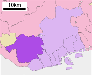
| Location Nishi-kus in the city of Kobe | ||
Nishi-ku ( Japanese 西区 'District West' ) is a municipality ( ku ) of Kobe . With 137.82 km² it is the second largest of nine in Kobe.
geography
The district adjoins the west of the Rokkō massif and includes part of the east end of the Banshū plain, borders the city of Akashi and extends to the city of Miki . Nishi-ku is a bit away from the city center, but apart from that it offers good quality of living, lots of space and lots of greenery.
traffic
The Seishin-Yamate line of the subway from Kobe extends to the satellite city of Seishin and crosses the university and residential district of Gakuentoshi , which was also created in the 1980s .
education
In Nishi-ku there are four other universities and colleges in addition to the Hyōgo Prefectural University and the municipal foreign language college Kobe.
Attractions
Sights are the temple Taisan-ji ( 太 山寺 ) and a part of the newly opened Akashi-Kaikyō National Government Park lying on Honshū north and south of the Akashi-Kaikyō Bridge .
Web links
- Akashi-Kaikyō National Government Park (Japanese)
Individual evidence
- ↑ Kobe City University of Foreign Studies (English)

