
Shimogyō-ku (Kyoto)
|
Municipality of Kyoto |
|
|---|---|
  |
|
| Coordinates | 34 ° 59 '15 " N , 135 ° 45' 20" E |
| surface | 6.82 km² |
| Residents | 82,680 (Oct 1, 2019) |
| Population density | 12,123 inhabitants / km² |
| Start-up | Apr 10, 1879 |
| Community key | 26106-8 |
Administration address |
608-8, Nishidōin-dōri Shiokōji agaru, Higashishiokōjichō, Shimogyō-ku, Kyōto 600-8588 |
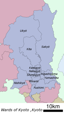
Shimogyō-ku ( Japanese 下 京 区 , German "lower capital district") is one of eleven districts ( ku ) of Kyōto , Japan .
history
It was founded on April 10, 1879 as part of the old city prefecture of Kyōto ( Kyōto-fu ) . When the Japanese community was reorganized on April 1, 1889, the city ( shi ) Kyōto was formed from him and Kamigyō-ku . On April 1, 1929, the east was spun off as the district of Higashiyama-ku and formed from the northern part together with the southern part of Kamigyō-ku the municipality of Nakagyō-ku . It received its current boundaries on September 1, 1955 with the spin-off of Minami-ku in the south.
Attractions

Important structures are the Kyoto Tower and the Kyoto train station . Shijōstraße runs along the northern edge of the district, around which, especially at the intersection with Kawaramachistraße, is the liveliest shopping district in the city. The three rivers Hori , Kamo and Takase flow through Shimogyō-ku.
Web links
- official website (Japanese)
Fushimi-ku | Higashiyama-ku | Kamigyō-ku | Kita-ku | Minami-ku | Nakagyō-ku | Nishikyō-ku | Sakyō-ku | Shimogyō-ku | Ukyō-ku | Yamashina-ku