
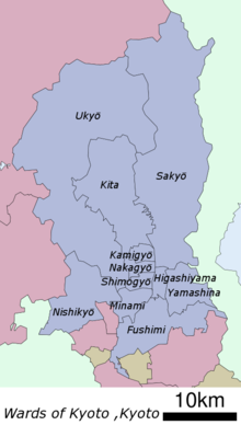
Ukyō-ku (Kyoto)
|
Municipality of Kyoto |
|
|---|---|
  |
|
| Coordinates | 35 ° 0 '37 " N , 135 ° 42' 58" E |
| surface | 291.95 km² |
| Residents | 203,670 (Oct. 1, 2019) |
| Population density | 698 inhabitants / km² |
| Incorporation | April 1, 1931 (10 parishes) |
| Community key | 26108-4 |
Administration address |
12, Uzumasa-Shimokeibuchō, Ukyō-ku, Kyōto 616-8511 |
Ukyō-ku ( Japanese 右 京 区 , German "right capital district") is one of eleven districts ( ku ) of Kyōto , Japan .
etymology
The name Ukyō, "right capital district", comes from the fact that the Japanese emperor sat facing south when he resided in the imperial palace , so that the western urban areas were on his right. Accordingly, the eastern district is called Sakyō-ku , which means "left capital district". Ukyō originally referred to the western parts of the city center, today's Ukyō-ku district, on the other hand, is largely outside the historical city limits and only overlaps with the old Ukyō in a few places .
history
Ukyō-ku was created on April 1, 1931 in the course of the incorporation of the city of Saga ( 嵯峨 町 , - chō ) and the villages of Hanazono ( 花園 村 , - mura ), Kyōgoku ( 京 極 村 , -mura ), Matsuo ( 松尾 村 , -mura ), Katsura ( 桂 村 , -mura ), Kawaoka ( 川岡 村 , -mura ), Sai ( 西 院 村 , -mura ), Umegahata ( 梅 ヶ 畑 村 , -mura ), Umezu ( 梅 津 村 , -mura ), Uzumasa ( 太秦村 , mura ) each from the district Kadono ( 葛野郡 , - gun ).
On December 1, 1950, Ōe ( 大 枝 村 , -mura ) and on November 1, 1959 Ōharano ( 大 原野 村 , -mura ) were incorporated into the district of Otokuni ( 乙 訓 郡 , -gun ). Both were then spun off again on October 1, 1976 together with Matsuo, Katsura and Kawaoka as the new Nishikyō-ku district .
With the last incorporation of the city of Keihoku ( 京 北 町 , -chō ) from the district of Kitakuwada ( 北 桑田 郡 , -gun ) on April 1, 2005 , the urban area almost quadrupled from 74.27 to 291.95 km².
Attractions

Significant places in the district include the "Bridge to the Moon" - Togetsu-kyō - in the Arashiyama district , the Buddhist temple complex Ninna-ji , the Zen temple complex Myōshin-ji , the Zen temple Ryōan-ji with its famous gravel garden, the Daikaku-ji temple in the Sagano district and the Kōryū-ji temple in the Uzumasa district . The Kyōto Prefectural University is located in the district of Nakaragi . Ukyō-ku is also a center of the Japanese film industry, including one of the Tōei's two film studios .
Web links
- official website (Japanese)
Fushimi-ku | Higashiyama-ku | Kamigyō-ku | Kita-ku | Minami-ku | Nakagyō-ku | Nishikyō-ku | Sakyō-ku | Shimogyō-ku | Ukyō-ku | Yamashina-ku