
Kamigyō-ku (Kyoto)
|
Municipality of Kyoto |
|
|---|---|
  |
|
| Coordinates | 35 ° 1 '46 " N , 135 ° 45' 25" E |
| surface | 7.11 km² |
| Residents | 84,539 (Oct 1, 2019) |
| Population density | 11,890 inhabitants / km² |
| Start-up | Apr 10, 1879 |
| Community key | 26102-5 |
Administration address |
289, Imadegawa-dōri Muromachi nishi-iru, Horidashichō, Kamigyō-ku, Kyōto 602-8511 |
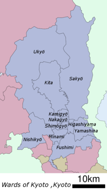
Kamigyō-ku ( Japanese 上京 区 , German "upper capital district") is one of eleven districts ( ku ) of Kyōto , Japan . It lies roughly in the middle of today's Kyoto and forms the northern part of the historic city center. The eastern boundary of the borough runs along the Kamo River .
history
It was founded on April 10, 1879 as part of the old city prefecture of Kyōto ( Kyōto-fu ) . When the Japanese community was reorganized on April 1, 1889, the city ( shi ) Kyōto was formed from him and Kamigyō-ku . On April 1, 1929, the east was spun off as the municipality of Sakyō-ku and formed from the southern part together with the northern part of Shimogyō-ku the municipality of Nakagyō-ku . It received its current borders on September 1, 1955 with the spin-off of Kita-ku in the north.
Attractions
In the past, when Kyoto was the capital of Japan , the area was shaped by the residences of the imperial family and the ruling class. In the district are the Imperial Palace of Kyoto , the Shōkoku-ji Temple , the Kitano Tenman-gū ( Shintō Shrine ), the Seimei Shrine and the Imadegawa campus of the Dōshisha University . The silk textiles (nishijin-ori) for which Kyoto is famous come from Kamigyō.
District administration

The Shishinden main hall in the Imperial Palace of Kyoto


Web links
- official website (Japanese)
Fushimi-ku | Higashiyama-ku | Kamigyō-ku | Kita-ku | Minami-ku | Nakagyō-ku | Nishikyō-ku | Sakyō-ku | Shimogyō-ku | Ukyō-ku | Yamashina-ku