
Hakone (volcano)
| Hakone | ||
|---|---|---|
.jpg) View from the southwest |
||
| height | 1438 m TP | |
| location | Hakone , Kanagawa , Honshu | |
| Coordinates | 35 ° 14 '0 " N , 139 ° 1' 15" E | |
|
||
| Type | Complex volcano | |
| rock | Andesite , basalt , dacite | |
| Age of the rock | quaternary | |
| Last eruption | June 2015 | |
| particularities | Part of the Fuji Hakone Izu National Park | |

The Hakone ( Jap . 箱根山 , Hakone-yama ) is a volcano on the Japanese island of Honshu . It is located about 80 kilometers southwest of Tokyo in Kanagawa Prefecture , with a small part belonging to Shizuoka Prefecture . The complex volcano is up to 1438 m high and is surrounded by a caldera . The area of the volcano has been one of the most important tourist regions in the country since the 19th century . It is part of the Fuji-Hakone-Izu National Park , which also includes the Fuji volcano in the west and the Izu Peninsula in the south.
geography
The Hakone region is located near the point where three continental plates meet: the Eurasian plate , the North American plate and the Philippine plate . Administratively, the majority of the volcano is part of the town named after him Hakone district Ashigarashimo of Kanagawa Prefecture . Peripheral areas belong to various adjacent parishes in this prefecture as well as in neighboring Shizuoka Prefecture .
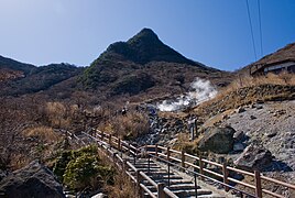
The Hakone is a complex volcano , that is, it comprises different types of volcanoes, none of which dominates the appearance. The rocks andesite , basalt and dacite are predominant . In the center, several stratovolcanoes line up in a north-south direction . The most northerly is the Sōunzan ( 1151 m TP ). It is followed by the Kamiyama (with 1438 m the highest elevation), the Kanmurigatake (1409 m), the Komagatake (1356 m), the Futagoyama (1091 m) and the Shimofutagoyama (1065 m). In front of these volcanic cones are several lava domes and areas with fumaroles , of which Ōwakudani is by far the best known.
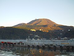
A caldera with a diameter of up to twelve kilometers extends around the central area . Various districts of Hakone are scattered around it. The western part is occupied by Lake Ashi , a seven kilometer long and up to 40 meter deep crater lake . An outer ring with several other elevations over 800 meters high surrounds the caldera. In the east it is broken by the deeply cut gorge of the Hayakawa, which flows south of Odawara into the Sagami Bay . The Sukumo, a tributary of the Hayakawa, flows through a short side caldera in the southeast and flows into the Hayakawa in the Yukomo district.
Volcanic activity
In the Middle Pleistocene , 650,000 years ago, there were several small volcanoes around what is now Hakone. Years ago, 230,000 is a large began Stratovolcano piling, which reached a height of about 2700 meters. After repeated eruptions , its center collapsed and a caldera was formed in the cavity that was created about 180,000 years ago . The old outer ring in the north dates from this time. Its northernmost elevation, the 1212 m high Kintokiyama, is the only one not the result of this collapse, but a parasitic flank volcano from the same time period.
After a quiet phase 130,000 years ago, a shield volcano surrounded by lava domes formed , which filled the original caldera. 80,000 to 60,000 years ago there was a phase of particularly intense volcanic activity. An extraordinarily violent Plinian eruption towards the end of this phase ejected five billion cubic meters of lava ; the pyroclastic flow stretched from the mouth of the Fuji River in the west to the area of Yokohama in the east. This created the new outer ring in the south and the caldera in its current size.
For the past 10,000 years, volcanic activity has been limited to the central cones within the caldera. Phreatic explosions occurred 8,000, 5,700, and 3,000 years ago. In the latter, the northwest flank of the Kamiyama collapsed; the rock masses buried the Hayakawa valley and dammed Lake Ashi . The last magmatic eruption so far occurred 2,900 years ago, in the 12th and 13th centuries there were three phreatic eruptions around Ōwakudani . Changes in the fumaroles and increased seismic activity have been recorded there repeatedly since the 1930s , the last time in June 2015.
traffic
The main access to the caldera with the various districts of the tourist city of Hakone is from Odawara through the Hayakawa Valley in the east, either via National Road 1 (formerly the Tōkaidō ) or via the Hakone-Tozan Line . There are also several passes over the outer ring. These are the Hakone Pass (848 m) to Mishima in the south, the Kojiri Pass (845 m) to Susono in the west and the Nagao Pass (952 m) and the Otome Pass (1006 m) to Gotemba in the northwest . Over the northern foothills, near the upper Sakawa valley, a road leads from Gotemba to Minamiashigara over the Ashigara pass (759 m), which was mentioned as early as the 8th century in the collection of poems Man'yōshū .
Bus routes from several companies provide for the fine development. Three cable cars are primarily used for tourist traffic: The Hakone Tozan Cable Car is a funicular in the Gōra district. The Hakone cable car runs from its mountain station via Ōwakudani to the northern end of Lake Ashi . From the east bank, the Hakone-Komagatake Cable Car runs near the Komagatake Summit. Excursion boats operate on Lake Ashi. A special feature are toll panoramic roads along the ridge of the caldera.
photos

Topographic map
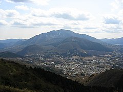
Kamiyama

Ashi lake

Kintokiyama
Kanmurigatake

Ōwakudani
Komagatake


Web links
- Hakone Geopark (English)
- Japan Meteorological Agency data sheet (PDF)
- Entry on the website of the Global Volcanism Program (English)
- Geological Office Datasheet (Japanese)
Individual evidence
- ↑ a b Geology. Hakone Geopark, 2018, accessed January 7, 2019 .
- ↑ 標高 値 を 改 定 す る 山岳 一 覧. (PDF, 60 kB) Geological Survey Institute, accessed January 7, 2019 (Japanese).
- ↑ 伊豆 東部 火山 群 の 時代 (24) 箱根 火山 最大 の 噴火. Izu Shimbun, November 16, 2008, accessed January 7, 2019 (Japanese).