
Tōkaidō
The Tōkaidō ( Japanese 東海 道 , dt. "Eastern Sea Route") was one of the most important post and trade routes ( Kaidō ) of ancient Japan . In the Edo period , it connected the seat of government of the Tokugawa Shogunate Edo (today's Tokyo ) with the imperial capital Kyoto .
Ritsuryo

With the introduction of the Ritsuryō administration system based on the Chinese model, Japan also took over the postal road system from China. In Article 2 of the Taihō Code of 701, this was introduced in Japan.
As one of these streets, the Tōkaidō was established, which initially had only a secondary meaning as a 2nd class street. It began in Seta, then ran through the southeast of the Ōmi province through the checkpoint ( 関 , seki or Sino-Japanese kan ) Suzuka no Seki ( 鈴鹿 関 ) in today's Kameyama , in the north of the Ise province , then roughly followed the Pacific coast to the Capital of Hitachi Province . The trunk road and region along the eastern one was referred to as Tokaidō. The road also had three major branches:
- the Ise-ji ( 伊 勢 路 ), which led from Suzuka south to the Ise shrine in the province of Ise and east to the province of Shima ;
- the Kai-ji ( 甲 斐 路 ), which branched off in Suruga Province to form the capital of Kai Province ;
- a side street, in the Shimōsa Province to Province Awa on the Bōsō Peninsula branched off.
In addition, there was a connecting piece that connected the Tōkaidō with the roughly north parallel Tōsandō , which also began in Suzuka, from Hitachi via the district of Higashishirakawa in the province of Iwaki .
After Minamoto no Yoritomo proclaimed the Kamakura shogunate and the seat of government moved to Kamakura in 1192 , the Tōkaidō rose to become the most important street in Japan.
In addition, Japan was divided into eight major regions with the Gokishichidō system. The individual provinces of the seven ( shichi ) outer regions were connected to the five provinces of the inner region Kinki ( goki ) via a system of trunk roads ( dō ) and took over the names of these trunk roads. The Tōkaidō region consisted of the following provinces:
- Iga Province
- Ise Province
- Shima Province (separated from Ise in the 8th century)
- Owari Province
- Mikawa Province
- Tōtōmi Province
- Suruga Province
- Izu Province
- Kai Province
- Sagami Province
- Musashi Province (before 771 in Tōsandō Region)
- Awa Province (718 separated from Kazusa, 741 separated from Kazusa, 757 separated again)
- Kazusa Province (part of the ancient Fusa Province )
- Shimousa Province (part of the ancient Fusa Province)
- Hitachi Province
Edo period


During the Edo period ( 1603 - 1867 ) it was redesigned as one of the "Five Streets" ( Gokaidō ) and now linked Edo (today's Tokyo) with Kyoto. Over a length of 488 kilometers it ran first from Tokyo to Nagoya along the east coast of Honshū and then over the mountains and along the south bank of Lake Biwa to Kyoto. During the Edo period, the Tōkaidō was an important traffic artery and an essential means of power ( Sankin kōtai ) for the Shōgun dynasty to maintain control of the country. The main checkpoint was the Hakone Sekisho ( 箱根 関 所 ). The designation of the areas around Tōkyō as Kantō ( 関 東 , "east of the checkpoint") and around Kyōto as Kansai ( 関 西 , "west of the checkpoint") goes back to this . In the interior, traffic was conducted over the Nakasendō .
The 53 classic stations of Tōkaidō
A total of 53 stations ( 宿 場 , shukuba ) were built along the Tōkaidō between the Nihonbashi bridges in Edo and Sanjō-Ōhashi in Kyōto . Guesthouses, post offices and customs stations were built. The individual stations are:


| No. | Station name | distance | Place (historical / modern) | ||||
|---|---|---|---|---|---|---|---|
| transcription | Kanji | province | district | prefecture | local community | ||
| - | Nihonbashi | 日本 橋 | (Begin) | Musashi | Toshima | Tokyo | Chūō |
| 1 | Shinagawa-juku | 品 川 宿 | 2 ri | Ebara | Shinagawa | ||
| 2 | Kawasaki-juku | 川 崎 宿 | 2½ ri | Tachibana | Kanagawa | Kawasaki-ku , Kawasaki | |
| 3 | Kanagawa-juku | 神奈川 宿 | 2½ ri | Kanagawa-ku , Yokohama | |||
| 4th | Hodogaya-juku | 程 ヶ 谷 宿 | 1 ri 9 chō | Hodogaya-ku , Yokohama | |||
| 5 | Totsuka-juku | 戸 塚 宿 | 2 ri 9 chō | Sagami | Kamakura | Totsuka-ku , Yokohama | |
| 6th | Fujisawa-juku | 藤 沢 宿 | 1 ri 30 chō | Kamakura / Kōza | Fujisawa | ||
| 7th | Hiratsuka-juku | 平 塚 宿 | 3½ ri | Ōsumi | Hiratsuka | ||
| 8th | Ōiso-juku | 大 磯 宿 | 27 chō | Yurugi | Ōiso | ||
| 9 | Odawara-juku | 小田原 宿 | 4 ri | Ashinoshimo | Odawara | ||
| 10 | Hakone-juku | 箱根 宿 | 4 ri 8 chō | Hakone | |||
| 11 | Mishima-juku | 三島 宿 | 3 ri 28 chō | Izu | Kimisawa | Shizuoka | Mishima |
| 12 | Numazu-juku | 沼 津 宿 | 1½ ri | Suruga | Sunto | Numazu | |
| 13 | Hara-juku | 原宿 | 1½ ri | ||||
| 14th | Yoshiwara-juku | 吉 原宿 | 3 ri 6 chō | Fuji | Fuji | ||
| 15th | Kambara-juku | 蒲 原宿 | 2 ri 30 chō | Ihara | Shimizu-ku , Shizuoka | ||
| 16 | Yui-juku | 由 比 宿 | 1 ri | ||||
| 17th | Okitsu-juku | 興 津 宿 | 2 ri 12 chō | ||||
| 18th | Ejiri-juku | 江 尻 宿 | 1 ri 3 chō | ||||
| 19th | Fuchu-juku | 府中 宿 | 2 ri 29 chō | Udo | Aoi-ku , Shizuoka | ||
| 20th | Mariko-juku | 鞠 子 宿 | 1½ ri | Suruga-ku , Shizuoka | |||
| 21st | Okabe-juku | 岡 部 宿 | 1 ri 29 chō | Shida | Fujieda | ||
| 22nd | Fujieda-juku | 藤枝 宿 | 1 ri 29 chō | ||||
| 23 | Shimada-juku | 島 田 宿 | 2 ri 8 chō | Shimada | |||
| 24 | Kanaya-juku | 金谷 宿 | 1 ri | Tōtōmi | Haibara | ||
| 25th | Nissaka-juku | 日 坂 宿 | 1 ri 24 chō | Saya | Kakegawa | ||
| 26th | Kakegawa-juku | 掛 川 宿 | 1 ri 19 chō | ||||
| 27 | Fukuroi-juku | 袋 井 宿 | 2 ri 16 chō | Yamana | Fukuroi | ||
| 28 | Mitsuke-juku | 見 付 宿 | 1½ ri | Iwata | Iwata | ||
| 29 | Hamamatsu-juku | 浜 松 宿 | 4 ri 7 chō | Fuchi | Naka-ku , Hamamatsu | ||
| 30th | Maisaka-juku | 舞 坂 宿 | 2 ri 30 chō | Nishi-ku , Hamamatsu | |||
| 31 | Arai-juku | 新居 宿 | 1 ri | Kosai | |||
| 32 | Shirasuka-juku | 白 須 賀 宿 | 1 ri 24 chō | Hamana | |||
| 33 | Futagawa-juku | 二 川 宿 | 2 ri 16 chō | Mikawa | Atsumi | Aichi | Toyohashi |
| 34 | Toyohashi-juku | 吉田 宿 | 1 ri 20 chō | ||||
| 35 | Goyu-juku | 御 油 宿 | 2 ri 22 chō | Hoi | Toyokawa | ||
| 36 | Akasaka-juku | 赤 坂 宿 | 16 chō | ||||
| 37 | Fujikawa-juku | 藤 川 宿 | 2 ri 9 chō | Nukata | Okazaki | ||
| 38 | Okazaki-juku | 岡 崎 宿 | 1 ri 25 chō | ||||
| 39 | Chiryu-juku | 池 鯉 鮒 宿 | 3 ri 30 chō | Hekikai | Chiryu | ||
| 40 | Narumi-juku | 鳴 海 宿 | 2 ri 30 chō | Owari | Aichi | Midori-ku , Nagoya | |
| 41 | Miya-juku | 宮 宿 | 1½ ri | Atsuta-ku , Nagoya | |||
| 42 | Kuwana-juku | 桑 名宿 | 3 ri | Ise | Kuwana | Mie | Kuwana |
| 43 | Yokkaichi-juku | 四日 市 宿 | 3 ri 8 chō | Mie | Yokkaichi | ||
| 44 | Ishiyakushi-juku | 石 薬 師 宿 | 2 ri 27 chō | Suzuka | Suzuka | ||
| 45 | Shono-juku | 庄 野 宿 | 27 chō | ||||
| 46 | Kameyama-juku | 亀 山 宿 | 2 ri | Kameyama | |||
| 47 | Seki-juku | 関 宿 | 1½ ri | ||||
| 48 | Sakashita-juku | 坂 下 宿 | 1 ri 24 chō | ||||
| 49 | Tsuchiyama-juku | 土 山 宿 | 2½ ri | Ōmi | Coca | Shiga | Coca |
| 50 | Minakuchi-juku | 水口 宿 | 2 ri 25 chō | ||||
| 51 | Ishibe-juku | 石 部 宿 | 3 ri 12 chō | Konan | |||
| 52 | Kusatsu-juku | 草津 宿 | 2 ri 25 chō | Kurita | Kusatsu | ||
| 53 | Ōtsu-juku | 大 津 宿 | 3 ri 24 chō | Shiga | Ōtsu | ||
| - | Sanjō-Ōhashi | 三条 大橋 | 3 ri | Yamashiro | Atagi | Kyoto | Higashiyama-ku , Kyoto |
today
In the course of the modernization of Japan in the Meiji period and in the 20th century , the original route of the Tōkaidō was no longer used in parts. However, other routes are still used today as normal roads, sometimes even as National Road No. 1 .
Today the course of the Tōkaidō is the busiest traffic route in Japan. It connects Tokyo (Japan's capital and largest city) via Nagoya with Kyōto and Osaka. The Tokyo- Nagoya -Kyōto- Ōsaka route is followed by the Tōkaidō main line (railway) and the Tōmei and Meishin expressways . One of the first Japanese high-speed train routes ( Shinkansen ), which has connected Tokyo with Osaka since 1964 , was named Tōkaidō Shinkansen in memory of the traditional trade route .
In Japanese art
The Tōkaidō exerted a great fascination on Japanese artists and poets. The best known is the woodcut cycle 53 stations of the Tōkaidō or the Hoeidō edition by the artist Utagawa (Andō) Hiroshige .
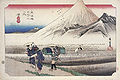
Station 13: Hara

Station 16: Yui


literature
- Patrick Carey: Rediscovering the old Tokaido. In the Footsteps of Hiroshige . Global oriental, 2000, ISBN 1-901903-10-9
- JT Traganou: The Tokaido Road: Traveling and Representation in Edo and Meiji Japan . Routledge Curzon, 2003, ISBN 0-415-31091-1
Web links
- Hiroshige: 53 stations of the Tōkaidō (English)
- Utagawa's Tōkaidō series
- Interactive Tour (English)
Individual evidence
- ^ Robert B. Hall: The Road in Old Japan . In: Studies in the History of Culture: The Disciplines of the Humanities . 1942, LCCN 42-013513 , pp. 130 ( limited preview in Google Book search).
- ^ A b Robert B. Hall: The Road in Old Japan . In: Studies in the History of Culture: The Disciplines of the Humanities . 1942, LCCN 42-013513 , pp. 134 ( limited preview in Google Book search).