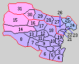
Mie-gun
Mie ( Japanese 三重 郡 Mie-gun ) is the eponymous district (- gun ) of the Japanese prefecture (-ken) Mie . It is located in the north of the prefecture between the Suzuka Mountains and the Ise Bay . Since 2005, the district of Mie still consists of three communities: the cities (-chō) Komono in the west at the foot of the mountains and Asahi and Kawagoe in the east by the bay.
history
Under the ancient Ritsuryō administrative division, which was used as a geographical division of the country partly until the early 20th century (and occasionally until today), Mie was one of the 13 districts of the province (kuni / -shū) Ise / Sei [shū] .
When, after the Meiji Restoration, the prefecture administration of Anotsu was relocated from Anotsu in what was then Anō County (later from 1889 as Tsu-shi district-free) to Yokkaichi in Mie County, the prefecture was renamed Mie after the county of the administrative center. The capital was later moved back, but the name stayed.
The originally modern Mie district consisted of large parts of today's independent city of Yokkaichi and parts of today's Komono after the districts were reactivated as an administrative unit in 1878/79 . In the Great Meiji Territorial Reform to introduce the modern communities in 1889, Mie was divided into 19 communities: the city of Yokkaichi as the administrative seat (1st on the map), the village of Komono (14th) and 17 other villages. In 1896, the Mie-gun reached its greatest extent when it was merged with the previous Asake district when implementing the district order in Mie . Since Yokkaichi became an independent city (-shi) in 1897 , Mie County lost much of its territory to them in the 20th century. As in all of Japan, the district was dissolved as an administrative unit in the 1920s, but is still used as a geographical unit and its composition is updated. The last loss of territory so far took place in 2005 when the city of Kusu was incorporated into Yokkaichi.
Web links
- Change of gun in the Kinki region [since 1869] (Japanese), Chiri data-shū, Ishida Satoshi.

