Nihombashi
Nihombashi ( Japanese 日本 橋 , alternative Romanization Nihonbashi ), the "Japan Bridge", is a bridge in the Chūō district of the Japanese prefecture of Tokyo and a district named after it in the same district. Both are located in the eastern center of Tokyo , the former Edo .
The bridge


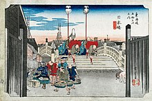
The first wooden Nihombashi was built in 1603 under Shogun Tokugawa Ieyasu when he formally established the seat of government in Edo. It became the starting point of the Gokaidō , the five main roads that connected Edo with the provinces.
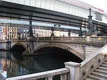
The bridge burned down several times, so that today's stone bridge built in 1911 is already the 20th Nihombashi. This also survived the Tōkyō Daikūshū , the Great Air Raid on Tokyo of March 10, 1945, even if traces of the incendiary bombs can still be seen today. In 1999 the bridge was designated as an "important cultural asset" of Japan.
To this day, the Nihombashi with the dōro gempyō is the reference point for distance information to Tokyo and the starting point of national roads 1 and 4 , as well as the 6 , 14 , 15 , 17 and 20 branching off near them . Today it is also (indirectly) the starting point of the continental AH1 . This starts on the Tokyo C1 city freeway crossing the bridge . The fundamental point of Japan ( 日本国 道路 元 標 , Nippon koku dōro genpyō ) is located in Tokyo in the middle of the Nihonbashi.
The district
The area around the traffic junction Nihombashi developed into a business district in the area between the castle and the aristocratic residences in the west - the Yamanote line lies in this area at the former outer moat - and the "lower town" in the east. The Mitsui family founded Echigo-ya here as early as the 17th century, the forerunner of today's Mitsukoshi department store .
After the Meiji Restoration, the Nihombashi district was established in 1878 , which included the northern part of today's Chūō, and in 1889 it became a district of the new city of Tokyo . After this had been dissolved in the Pacific War and the district was united with Kyōbashi to Chūō in 1947 , most of the districts in the former district received the addition Nihombashi . The boundaries of the former district can still be recognized today, and today's district of Higashi-Nihombashi , ie "East Nihombashi", is not located directly east of Nihombashi, but in the very northeast of the Chūō district at the confluence of the Kanda with the Sumida .
It was not until 1970 that today's Nihombashi district was established, the northwest corner of which forms the bridge. It borders Yaesu to the west, Kyōbashi to the south, Kabutochō to the east and is divided into three chōme districts numbered from north to south , in which, according to registration statistics, 351 inhabitants lived in 233 households as of July 1, 2016. The postal code of Nihombashi is 103-0027.
Mainly office and commercial buildings are located here, including the main department store of Takashimaya , the Maruzen main building and the COREDO Nihombashi office tower .
The Ginza Line and the Tōzai Line of the Tōkyō Metro and the prefecture-operated Asakusa Line meet at Nihombashi (underground) station . The inner ring line of the Tokyo city motorway , which surrounds the district in the north and east, can be reached via the junctions Edobashi in the north and Takarachō in the southeast.
Web links
Individual evidence
- ^ MLIT , Kanto Regional Development Office: History of the Nihombashi
- ↑ 町 丁目 別 世 帯 数 男女 別人 口 (residents by district). (No longer available online.) In: Chūō District. July 1, 2016, archived from the original on July 27, 2016 ; accessed on July 27, 2016 (English). Info: The archive link was inserted automatically and has not yet been checked. Please check the original and archive link according to the instructions and then remove this notice.
Coordinates: 35 ° 41 ′ 2.6 ″ N , 139 ° 46 ′ 28.1 ″ E

