Numazu
| Numazu-shi 沼 津市 |
||
|---|---|---|
| Geographical location in Japan | ||
|
|
||
| Region : | Chūbu | |
| Prefecture : | Shizuoka | |
| Coordinates : | 35 ° 6 ' N , 138 ° 52' E | |
| Basic data | ||
| Surface: | 187.10 km² | |
| Residents : | 189,476 (October 1, 2019) |
|
| Population density : | 1013 inhabitants per km² | |
| Community key : | 22203-8 | |
| Symbols | ||
| Flag / coat of arms: | ||
| Tree : | jaw | |
| Flower : | Crinum asiaticum | |
| Bird : | Common gull | |
| town hall | ||
| Address : |
Numazu City Hall 16 - 1 , Miyuki-chō Numazu -shi Shizuoka 410-8601 |
|
| Website URL: | http://www.city.numazu.shizuoka.jp/ | |
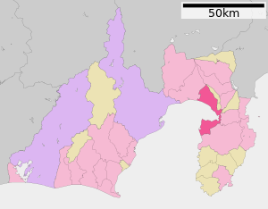
| Location Numazus in Shizuoka Prefecture | ||
Numazu ( Japanese 沼 津市 , - shi ) is a port city in Shizuoka Prefecture on Honshū .
geography
Numazu is 130 km west of Tokyo , at the confluence of the Kano River in Suruga Bay . Mount Ashitaka forms the northern border . The city is located at the origin of the Izu Peninsula , a recreational area known for hot thermal springs ( onsen ).
history
Hara - incorporated in 1968 - was a post office ( 宿 場 町 Shukuba-machi ) of the Tōkaidō during the Edo period .
The city was founded on July 1, 1923 .
During the Second World War , the city was bombed several times between November 1944 and July 1945 by the United States Army Air Forces (USAAF). The most serious attack was an area bombing with napalm bombs on July 17, 1945. The attacks destroyed around 42% of the urban area and killed 322 people. The incendiary bombs burned 11,883 buildings in the city. (see air raids on Japan )
From the Meiji period until 1969 , the Japanese imperial court had a villa here.
traffic
- Street
- Tōmei Highway
- National road 1 , to Tōkyō or Kyōto
- National Road 246,414
- Train ( Numazu Station )
- JR Gotemba Line to Kōzu
- JR Tōkaidō main line to Tokyo , Nagoya , Kyōto and Osaka .
The Numazu tram ran from 1906 to 1963 .
Important persons
- Nagakura Saburō (1920-2020), physical chemist
- Masahiro Fukasawa (born 1977), football player
- Tatsuya Hasegawa (* 1994), football player
- Yasushi Inoue (1907–1991), narrator
- Kyōko Iwasaki (* 1978), swimmer
- Nobutaka Machimura (1944-2015), politician
- Kōji Murofushi (* 1974), track and field athlete
- Yamada Nagamasa (1590–1630), adventurer and ruler of a province in Siam
- Norio Ōga (1930–2011), businessman
- Shinji Ono (* 1979), soccer player
- Serizawa Kōjirō (1896-1993), writer
- Yoshihiro Shōji (* 1989), football player


