
Siam
.svg)
As Siam (also Siem , Sejem , Sayam , Thai สยาม [ sàjǎːm ] ) was until 1939 the country in Southeast Asia indicated that the majority of today's Thailand equivalent. After the Second World War and the end of the Japanese occupation, the name was used again from 1946 to 1949.
The core area of historical Siam was in the basin of the Mae Nam Chao Phraya (Chao Phraya River) . At the time of its greatest expansion in the 19th century, its area of influence corresponded roughly to today's territory of Thailand, Cambodia and Laos as well as parts of Malaysia , Myanmar and Vietnam .
Like other Southeast Asian empires, Siam was not a nation state with clearly defined borders until well into the 19th century . With Siam areas were regarded as more abroad, from a certain center of power - Sukhothai 1238-1351, Ayutthaya to 1767, Thonburi to 1782 and then Rattanakosin or Bangkok - were dependent. The degree of dependence, however, was graduated and decreased from the center to the edge. While in areas near the respective capital the king ruled directly or through governors appointed by him, on the fringes there were communities with great autonomy and their own rulers who were obliged to pay tribute to Siam . However, these could also be dependent on several realms at the same time, i.e. belong to overlapping zones of influence ( mandala model ).
It was not until the reign of King Ramas IV (Mongkut; 1851–1868) that Siam was also used as a self-denomination, previously the self-denomination had always been the name of the capital. The idea of Siam as a geographically defined national area (geo-body) only developed during the colonization of the areas surrounding Siam by France and Great Britain . Siam itself was never a colony.
History of the term
Early Uses
Thai historians like to refer to a relief in Angkor Wat (southern gallery) from the 12th century, on which “Siam” is mentioned for the first time. Here a certain Jayasinghavarman is portrayed in a long troop parade in front of Suryavarman II, leading troops from Lavo (now Lop Buri ) and a group of “Syam Kuk” mercenaries. These "brown-skinned people" - this is probably the original meaning - are said to come from the area of the Kok River , which flows in what is now Chiang Rai Province . In the Pali English lexicon of Rhys Davids (The Pali Text Society, London), Sayam , which has the root Sama , is translated as 'black, yellow, green or golden'.
Towards the end of the 13th century, "Siem" is mentioned in Chinese sources, a Thai tribe from the Chao Phraya Valley .
One of the first Thai texts to use the term "Siam" is the epic poem Yuan Phai from the time of King Borommatrailokanat of Ayutthaya (around 1475). There, "Siam" is only used in compound words with Sanskrit or Pali terms, namely in the syntax determinant-basic word, which is usual for these languages , instead of the basic word-determinant, as is common in Thai. Specifically, the Yuan Phai speaks of "siam-phak" (from Pali bhāga ), ie the "Siam region". Similar is the use of “siam-deśa” (“Land of Siam”) and “siam-raṭṭha” (“State of Siam”) in the Jinakalamali chronicle written in Chiang Mai on Pali in the early 16th century : there, too, “Siam “Only in combination with Pali words, so it is clearly recognizable as a foreign or loan word and not as an original Thai term. On the other hand, there is the use of Thai , which is already used in the Ramkhamhaeng inscriptions of the Sukhothai era (around 1300) to describe individual people, one's own ethnic group, social units, one's own script and the calendar, and for the Thai language typical syntax (basic word - determinative word) is combined with Thai hereditary words (e.g. Müang Thai , "common ways of Thai"). This use continued into the early 19th century. In the Three Seal Laws codified under Rama I in 1805, Thai occurs more than a hundred times , but Siam only three times , exclusively in combination with loan words from Sanskrit and (from a Thai point of view) the opposite syntax: "siam-phasa " (From Sanskrit bhāsā ) for" Siamese language "and " siam-prathet " (from pradeś ) for the" land of Siam ".
'Siam' as an external name and as a self-name

The first Europeans to report on Siam were the Portuguese , who under Viceroy Afonso de Albuquerque had learned of a "Kingdom of Sayam" and a king in Ayutthaya after the conquest of Malacca in 1511 .
Simon de La Loubère, who was the French envoy in Ayutthaya in 1687, wrote in 1691 in his book Du royaume de Siam (German description of the Kingdom of Siam ):
- “The name Siam is unknown to the Siamese. It is one of the words which the Portuguese use in India and whose origin can hardly be discovered. […] The Siamese have given themselves the name Tai, that is, the free ones , what meaning this word currently has in their language. [...] Those who understand the language of Pegu [ie the Mon language ] assure that Siam is called frey in this language . "
- ("Le nom de Siam est inconnu aux Siamois. C'est un de ces mots dont les Portugais des Indes se servent, & dont on a la peine de decouvrir l'origine. […] Les Siamois se sont donné le nom de Táï , c'est à dire libres , selon ce que ce mot signifie aujourd'huy en leur Langue […] Et ceux qui savent la Langue du Pegu assurent que Siam en cette Langue veut dire libre ”).
His contemporary Kosa Pan , head of the Siamese embassy to the French court of Louis XIV in 1686, spoke of Siam in French , but in his reports written in Thai he wrote Krung Sri Ayudhya ('Shining City of Ayutthaya').
The Prussian surveyor and cartographer Heinrich Berghaus confirmed in his explanation of the map of Hinterindiens , published in Asia in 1832 , that 'Siam' was the European name, first used by the Portuguese, and that its own name was "Muan-Thai" or "Meuang-Táï" . However, he led the term back to the Burmese name Shan (for the so-called Tai people to this day, who regarded the Berghaus and the Siamese as a single nation).
_of_Siam_Signature_(English).svg)
.svg)

It was not until King Rama IV (Mongkut) began to sign as Krung Sayam ( กรุง สยาม , literally 'City of Siam'). According to the still usual identification of ruler, capital and empire, this referred to firstly him personally, secondly the city of Bangkok and thirdly the kingdom he ruled. With the designation 'Siam', the court under Mongkut emphasized the ethnic diversity and size of the empire, which included not only the "land of the Thai" ( müang thai) , but also the peoples and principalities who "sought the protection of the king" ( Lao , Khmer , Malays and 'Khaek', i.e. Indians or Muslims). In his correspondence with Europeans, Mongkut signed with Rex Siamensium ( Latin for 'King of Siam'). When Mongkut's son Chulalongkorn (Rama V) visited India in 1872, he introduced himself as "King of Siam, sovereign of Laos and Malay".
Siam as "geo-body"
Up until the second half of the 19th century, however, there was still no idea which geographical area would be referred to as 'Siam'. Like other pre-colonial “empires” in Southeast Asia, which are better described as mandalas due to their network-like structure , his domain was defined by personal loyalties and dependencies and not by spatial boundaries. 'Siam' was therefore always that which was under the rule of the respective king. The bond between the principalities on its fringes and central power could increase and decrease over time. Until Rama IV, the Siamese kings never tried to have their territory explored or mapped. In the terminology introduced by the Thai historian Thongchai Winichakul , Siam did not have a "geo-body".
In the 19th century, however, the colonization of Southeast Asia by Great Britain and France advanced. The two empires measured and mapped their colonial areas in detail and, as is common in Europe, precisely defined their borders. As a result, Siam was inevitably defined spatially, initially negatively: Siam therefore comprised the areas that were not (yet) colonized by the British or French, the “space in between”.
The fourth edition of Meyers Konversations-Lexikon (published 1885-1892) defined Siam as a "great empire on the peninsula of India" with an area of 726,850 km² and 5,750,000 inhabitants. This was divided into "actual Siam and Laoland", " Siemrab and Battambong " (ie the northern and western parts of Cambodia that remained with Siam after 1867) and "tributary Malay states".
The two colonial powers also extended their claim to rule to areas previously dependent on Siam. The most decisive event in this development was the so-called Paknam incident in 1893, in which French gunboats sailed the Chao Phraya River in the direction of Bangkok and fought a gun battle with a Siamese coastal fort. When the French then set up a naval blockade, Siam was forced to meet the French demands and cede large parts of what is now Laos to France in order to at least maintain its independence.
At the same time, King Chulalongkorn implemented radical political, social, economic and military reforms. These strengthened the integration of the regions on the edge of the rulership, which had not previously been seen as part of the actual Siam and enjoyed a high degree of autonomy, into the Siamese state. The present-day north and north-east regions were then no longer regarded as “Lao” countries, but as constitutive parts of Siam, as were the northern Malay sultanates in the south of the empire. So Siam got a positive spatial definition from the inside as “our space”, which had to be defended against the threat from outside.
After further forced cessions to the British and French colonial empires, Siam assumed the exact borders of present-day Thailand in 1909. In 1932 a group of younger military and intellectuals undertook an overthrow that changed the form of government from an absolute to a constitutional monarchy .
Renaming in Thailand and name discussion since then
On June 24, 1939, the name of the country was changed from "Siam" to "Thailand" ( Thai : ประเทศไทย - [pratʰêːt-tʰai]) at the instigation of the dictator Plaek Phibunsongkhram . The reason given was that "Siam" was a name that was only used by foreigners. On the one hand, 'Thailand' was intended to manifest the predominance of the Tai tribes - who were defined as a unified Thai nation - within the country, as well as the claim to be the scattered “Thai family of peoples”, some of which lived in “lost territories”, all in one To bring together the “Greater Thai Empire”, ie to expand. This has caused controversial discussion to this day. After Phibunsongkhram was temporarily disempowered, the new constitution of 1946 renamed it to Siam, but after the second takeover of power by the nationalist field marshal, "Thailand" was enforced again in 1949.
Some intellectuals, including Sulak Sivaraksa and the historian Charnvit Kasetsiri , continue to prefer the term 'Siam'. Your most important argument is that 'Siam' has less nationalistic connotations than 'Thailand' and, unlike Thailand, also includes minority ethnic groups.
On the occasion of the adoption of a new constitution in 2007, ML Panadda Diskul , President of the Prince Damrong Rajanubhab Library, suggested that the name “Siam” be used as a second name alongside “Thailand”. After all, Greece is also known as Hellas, Switzerland also as Helvetia and the Netherlands also as Holland. The young generation shouldn't believe that “Siam” is just the name of shopping centers or a cinema.
See also
- History of Thailand
- Sukhothai (Kingdom) for the period from 1238 to 1438
- Kingdom of Ayutthaya for the period from 1351 to 1767
- Kingdom of Thonburi for the phase from 1767 to 1782
- Rattanakosin and Chakri dynasties for the period from 1782
literature
- Chris Baker , Pasuk Phongpaichit: A History of Thailand. 2nd edition, Cambridge 2009.
- Volker Grabowsky : A Brief History of Thailand. C. H. Beck, Munich 2010, ISBN 978-3-406-60129-3 , in particular section “Thailand or Siam?”, Pp. 17-20.
- Jit Phumisak : ความ เป็น มา ของ คำ สยาม ไทย, ลาว และ ขอ ม และ ลักษณะ ทาง สังคม ของ ชื่อ ชนชาติ ( Khwampenma khong kham Sayam Thai Lao lae Khom lae laksana thangsangkhom khong chu chongchat ; “Etymology of the terms Siam, Thaiom , the social properties of ethnonyms ”), 1976.
- Sven Trakulhun: Siam and Europe. The Kingdom of Ayutthaya in Western Reports 1500–1670. Wehrhahn, Laatzen 2006, ISBN 3-86525-252-4 .
- Thongchai Winichakul: Siam Mapped. A History of the Geo-Body of a Nation. University of Hawai'i Press, Honolulu 1994, ISBN 0-8248-1337-5 .
- David K. Wyatt : Thailand, a Short History. Silkworm Books, Chiang Mai 2001, ISBN 974-7047-44-6 .
- Contemporary reports
- François-Timoléon de Choisy: Journal du voyage de Siam fait en 1685 et 1686. S. Mabre-Cramoisy, Paris 1687.
- Guy Tachard : Voyage de Siam, des Pères Jésuites, Envoyez par le Roy aux Indes & à la Chine. Avec leurs Observations Astronomiques, Et leurs Remarques de Physique, de Géographie, d'Hydrographie, & d'Histoire. Arnould Seneuze et Daniel Horthemels , Paris 1686 ( online at Google Books ).
- Guy Tachard: Second Voyage du Père Tachard et des Jésuites envoyez par le Roy au Royaume de Siam. Pierre Mortier, Amsterdam 1688.
- François Henri Turpin: Histoire civile et naturelle du royaume de Siam. Costard, Paris 1771 ( digitized ).
- Claude de Forbin: Voyage du comte de Forbin à Siam. Hachette, Paris 1853.
- Miscellaneous Articles written for the Journal of Siam Society by His Late Royal Highness Prince Damrong. The Siam Society , Bangkok 1962 (without ISBN).
Web links
- Siam . In: Meyers Konversations-Lexikon . 4th edition. Volume 14, Verlag des Bibliographisches Institut, Leipzig / Vienna 1885–1892, p. 925.
- Description of the Kingdom of Siam, partial translation of the book by La Loubère. Archived from the original on June 23, 2012 ; Retrieved November 29, 2015 .
- Strategic Siam changes its name to Thai (English) - Illustrated article about the name change from "Life", July 31, 1939
Individual evidence
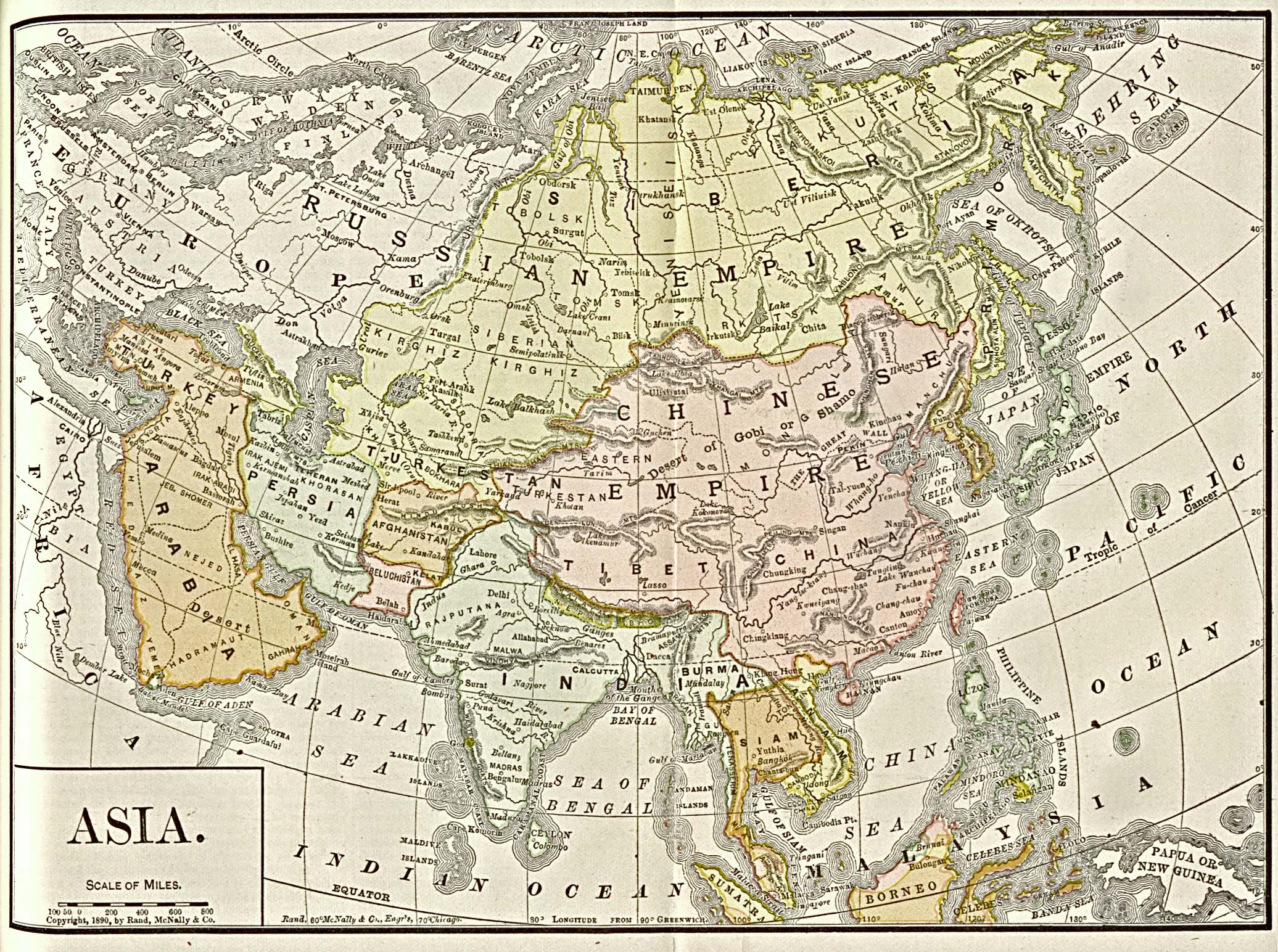
- ^ Historical map of Asia from 1892, Americanized Encyclopaedia Britannica, Vol. 1, Chicago 1892
- ↑ Thongchai Winichakul: Siam Mapped. 1994. The same: Maps and the Formation of the Geo-Body of Siam. In: Asian Forms of the Nation. Routledge, Oxford / New York 1996, pp. 67-92.
- ↑ Preecha Juntanamalaga: Thai or Siam? In: Names , Vol. 36, No. 1-2, 1988, pp. 69-84, at 71.
- ↑ a b Preecha Juntanamalaga: Thai or Siam? 1988, to 72.
- ↑ Simon de La Loubère: Description of the Kingdom of Siam. Translated from the French, Nürnberg 1800, pp. 9-10.
- ↑ Simon de La Loubère: Du Royaume de Siam. Paris 1691, pp. 18-19.
- ↑ Heinrich Berghaus: Geo-Hydrographisches Memoir for the explanation and elucidation of the reduced map of rear India. In: Asia. Collection of memoranda relating to the geography and hydrography of this part of the world. Perthes, Gotha 1832, p. 80.
- ↑ a b Baker, Pasuk: A History of Thailand. 2009, p. 63.
- ↑ Thongchai Winichakul: Siam Mapped. 1994, p. 116.
- ↑ Thongchai Winichakul: Siam Mapped. 1994, p. 115.
- ^ A b Thongchai Winichakul: Siam Mapped. 1994, pp. 130-131.
- ^ Meyers Konversationslexikon, 4th edition, Bibliographisches Institut, Leipzig / Vienna 1885-1892, 14th volume, p. 925.
- ↑ Grabowsky: Brief History of Thailand. 2010, p. 156.
- ^ Baker, Pasuk: A History of Thailand. 2009, p. 131 f.
- ^ Sulak Sivaraksa: Siam in Crisis. A collection of articles. Santi Pracha Dhamma Institute, 1990.
- ↑ Gerald Walton Fry: Thailand and Its Neighbors. Interdisciplinary Perspectives. Institute of Asian Studies, Chulalongkorn University, 2005, p. 131.
- ↑ Historian wants country called 'Siam'. ( Memento of the original from February 9, 2008 in the Internet Archive ) Info: The archive link was automatically inserted and has not yet been checked. Please check the original and archive link according to the instructions and then remove this notice. In: The Nation , April 3, 2007.
- ↑ "เหลน" กรม พระยา ดำรง ฯ หนุน ชื่อ "สยาม" ใน "ร ธน." ["Len" Krom Phraya Damrong Nun Chue "Sayam" nai "Ro Tho No"; Prince Damrong's great-grandson endorses Siamese name in constitution]. In: Matichon , No. 30/10626, April 14, 2007.