Shimada
| Shimada-shi 島 田 市 |
||
|---|---|---|
|
|
||
| Geographical location in Japan | ||
| Region : | Chūbu | |
| Prefecture : | Shizuoka | |
| Coordinates : | 34 ° 50 ' N , 138 ° 11' E | |
| Basic data | ||
| Surface: | 195.40 km² | |
| Residents : | 95,958 (October 1, 2019) |
|
| Population density : | 491 inhabitants per km² | |
| Community key : | 22209-7 | |
| Symbols | ||
| Tree : | Osmanthus fragrans var. Fragrans | |
| Flower : | Rose , Enkianthus perulatus | |
| Bird : | Japanese snapper | |
| town hall | ||
| Address : |
Shimada City Hall 1 - 1 , Chūō-chō Shimada -shi Shizuoka 427-8501 |
|
| Website URL: | http://www.city.shimada.shizuoka.jp | |
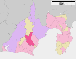
| Location of Shimadas in Shizuoka Prefecture | ||
Shimada ( Japanese 島 田 市 , - shi ) is a city in Shizuoka Prefecture in Japan .
geography
Shimada is located southwest of Shizuoka and northeast of Hamamatsu .
history
The city of Shimada was founded on January 1, 1948 .
Shimada was a post office ( 宿 場 町 Shukuba-machi ) of the Tōkaidō during the Edo period .
traffic
Shimada is located on National Road 1 from Tokyo to Kyoto , which partly follows the historic Tōkaidō Street.
The Shimada and Kanaya stations on the Tōkaidō Main Line are served by trains operated by JR Central . Kanaya is also the terminus of the Ōigawa main line operated by Ōigawa Tetsudō . This is a popular tourist destination due to the numerous special trips in historical vehicles.
Town twinning
-
 Richmond , California in USA , since 1961
 -
 Brienz BE , since 1996
 -
 Huzhou , since 1987
sons and daughters of the town
- Kitagawa Tamiji (1894–1989), painter and printmaker
- Takahiro Kawamura (* 1979), football player
Neighboring cities and communities
Web links
Commons : Shimada - collection of images, videos and audio files


