Wreechener See nature reserve
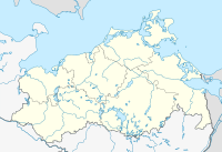
Location of the NSG in Mecklenburg-Western Pomerania |
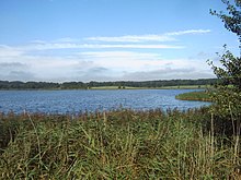
The nature reserve Wreechener See is a 72 hectare nature reserve in Mecklenburg-Western Pomerania, two kilometers south of Putbus . It was placed under protection on September 12, 1990 as part of the establishment of the Southeast Rügen Biosphere Reserve . The aim of the designation is to preserve a lagoon-like bay of the Greifswalder Bodden as one of the last regional resting areas for resting water birds. The Wreechener See is also characterized by silting societies and is a breeding area for rare bird species. Adjacent wet meadows are used extensively.
Surrounding places are Wreechen immediately to the east as well as Krakvitz and Neukamp . There is a connection to the Greifswalder Bodden.
The status of the area is considered to be satisfactory, as the water status is impaired by agricultural nutrient inputs. In 1997, the lack of oxygen in the water of the polytrophic lake resulted in massive fish deaths . The macrophyte flora , which has almost completely disappeared, has resettled in some areas in recent years. In the protected area, reeds are still harvested for reed advertising .
In the north of the nature reserve there is a refuge that gives an overview. The road from Neukamp to Wreechen runs right along the eastern border of the protected area.
According to EU law, the areas are part of the FFH area and bird sanctuary .
history
The Wreecher See was created from a block of dead ice during the last ice age . Due to the rise in sea level of the Littorina transgression , the areas flooded and got a connection to the bay. Coastal adjustment processes led to the formation of sand hooks, which separated the lake from the lagoon more and more. The lake silted up and a belt of trees and reeds formed. In the west, throughflow and spring bogs were created .
Two large stone graves south of the reserve indicate human habitation since the Neolithic . Prussian troops landed not far south of Neukamp in 1678 and began the invasion of Rügen .
Flora and fauna
Reeds influenced by the Bodden water surround the lake. Typical species are reeds , common brine , beach aster , salt pond rush , common pond rush and water mint . Adjacent meadows are interspersed with small areas of salt marshes . There are salt bungee , English elephant , beach and swamp trident , large flea herb , adder tongue and broad-leaved orchid .
Originally, ground lawns made of crested pondweed , horn leaf , brackish buttercup and chandelier algae were found in the lake . After these disappeared in the past decades due to nutrient inputs and the subsequent deterioration in water quality, new settlements of these species have been demonstrated in recent years.
Breeding birds in the area are reed warbler , reed bunting and various species of ducks . The nature reserve has an outstanding importance as a staging area for ducks, as Stock- , Tableware , heron , haddock and Pintail as well as Central , goose and Smew . In spring and autumn, predatory terns could also be observed.
Slow Worm , forest lizard , deciduous and green frog occur in the area.
literature
- Wreechener See 192 . In: Ministry of Environment Mecklenburg-Western Pomerania (Hrsg.): The nature reserves in Mecklenburg-Western Pomerania . Demmler-Verlag, Schwerin 2003, ISBN 3-910150-52-7 , p. 250 f .
Web links
- NSG regulation (from § 4)
- Map portal Umwelt MV with geodata (protected area borders, biotope mapping, etc.)
Individual evidence
- ↑ Standard data sheet Greifswalder Bodden, parts of the Strelasund and northern tip of Usedom (PDF; 103 kB)
- ↑ Standard data sheet EU bird sanctuary Greifswalder Bodden and southern Strelasund (PDF; 116 kB)
- ↑ Hexenbusch in the KLEKs
- ↑ Monument Prussian Column Neukamp in the KLEKs
- ↑ Biotope arch salt-influenced reed beds around the Wreechensee (PDF; 19 kB)
- ↑ Biotope arch salt-influenced reed beds around the Wreechensee (PDF; 19 kB)
Coordinates: 54 ° 19 ′ 49.9 ″ N , 13 ° 27 ′ 29.1 ″ E


