Buck (island)
| Buck (island) | ||
|---|---|---|
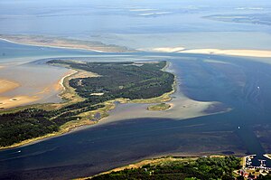
| Aerial view of the island of Bock | ||
| Waters | Baltic Sea | |
| Geographical location | 54 ° 27 ' N , 13 ° 3' E | |
|
|
||
| surface | 3.4 km² | |
| Residents | uninhabited | |
Bock is an uninhabited island in the Baltic Sea in Western Pomerania between the Zingst peninsula and the island of Hiddensee . It was created in the 20th century in the area of an extensive sandbank called the Bock . The island is under nature protection and is part of the core zone ("Protection Zone 1") of the Vorpommersche Boddenlandschaft National Park .
location
The sandbank, known as the Bock , extends from the eastern tip of the Zingst peninsula to the Gellenstrom , the fairway to the Stralsund harbor just before the island of Hiddensee . The island of Bock is located in its southeastern part, separated from the mainland with the town of Barhöft and the desert Zarrenzin by the narrow Barther waterway . The adjacent mainland area belongs to the municipality of Klausdorf (near Stralsund) , while Bock belongs to the southwestern municipality of Groß Mohrdorf . In the west, the island is separated from the Kleine Werder archipelago by narrow, shallow watercourses , with a tidal wave between and north of the Bock .
The island extends over a length of about six kilometers and is usually less than a kilometer wide. Their area is given as 3.4 square kilometers.
history
The name Bock for the sandbank east of the Zingst peninsula has come down to us from a number of texts and maps from the 19th century. It is derived from jacked up because stranded ships are jacked up on the sandbank. Some of today's islands were already permanently above the mean water level in the area of the sandbank, including the large and small Werder .
The sandbank was created naturally through the accumulation of sediment from the Darßer Ort area , which was transported eastward with the westward current. In addition, material is transported south from Dornbusch on Hiddensee, so that the Gellen in the south of the island continues to expand. Between the Bock and the Gellen lies the Gellenstrom, formerly also called Barhöfter Tief , a channel from the port of Stralsund to the Baltic Sea that tends to silt up.
In the 1930s, sand deposits were dredged from the fairway and brought onto the sandbank, then these higher-lying sands were reforested and have since then been permanently above water as the island of Bock. In 1939/40 two beacons were erected on the island.
From the 1960s, Bock was inaccessible to the public because the Ministry of State Security used the island to prevent attempts to escape . For this purpose, the border troops built five bungalows, four Finnhuts with residential units, a supply hut , a jetty with dolphins , and around 1,350 meters of flushing pipes. One of the residential huts stood at the pier and was used for passport and customs control . All buildings were demolished after the fall of the Wall until December 10, 1993.
The buck has been part of the Western Pomerania Lagoon Area National Park since 1990 . It is still closed to the general public , now for nature conservation reasons .

beacon
There are two beacons on the island, both of which were erected around 1939/40. The 13 meter high Bock lower light is on the south side, the 23 meter high upper light 660 meters away on the north side of the island. The beacons are listed.
vegetation
In the western part of the island is located on the former spoil field sandy dry grassland surrounded by land mount grassland and forest. Sand sedge silvergrass and now also sea buckthorn grow on the undulating, dry sandy soil of the island . Other typical species are Rotstraußgras , Mountain sand knobs , beach grass , sand straw flower , mouse ear hawkweed , beach rye , as well as various lichens and mosses.
Web links
Individual evidence
- ↑ The National Park Ordinance . Ordinance on the establishment of the Western Pomerania Lagoon Area National Park. , of September 12, 1990, § 4, Paragraph (2) 2., online .
- ↑ Statistisches Bundesamt (Ed.): Statistical Yearbook of the Federal Republic of Germany with international overviews, 2011, p. 18.
- ↑ Brochure: 10 Years of the Vorpommersche Boddenlandschaft National Park 1990 - 1999
- ↑ Bock leading light on deutsche-leuchtfeuer.de , accessed on August 13, 2017.
- ↑ List of monuments of the district of Vorpommern-Rügen
- ↑ www.umweltkarten.mv-regierung.de


