
Ruden (island)
| Ruden (island) | ||
|---|---|---|
 |
||
| Waters | Peenestrom | |
| Geographical location | 54 ° 12 '14 " N , 13 ° 46' 14" E | |
|
||
| length | 2.2 km | |
| width | 390 m | |
| surface | 24 ha | |
| Highest elevation | 3 m | |
| Residents | 2 8.3 inhabitants / km² |
|
| main place | Ruden | |
 |
||

The Ruden is an island in the mouth of the Peene River in front of the Baltic Sea coast belonging to Mecklenburg-Western Pomerania . The Ruden is located on the southern end of the Greifswalder Boddenrandschwelle , the remainder of a terminal moraine ridge . By Boddenrandschwelle the run as fairways Landtief north of Rudens and Osttief east and south of the Rudens. Administratively, the island belongs to the municipality of Kröslin .
geography
The flat island is 2.3 kilometers long from north to south. The maximum width of the island is 395 meters. The area is 24 hectares . The southern part with a length of 1.33 kilometers is a sandy peninsula only five to six meters wide in places, but nowhere more than 40 meters wide (more like a sandbank), which is protected from wave erosion by rubble stones and rubble groynes. At the southern end of the main island there is a 20 meter high brick tower that was built as an observation and measurement tower for Peenemünde. Here the island is only 1.9 kilometers from the coast at Peenemünder Haken.
Origin of name
The name "Ruden" is probably derived from the Slavic word "Rudin" (from "rod" = gender, family tree, homeland) or "rotŭ" for Rodeland, also "ruda" for iron ore would be possible. A derivation from the Germanic "Rud-ön" (from rod = root or uproot, clear) is not excluded.
The meanings flow together in Indo-European (rd = from, out, from in the sense of “origin”).
The island was first referred to as "Ruden" in 1618 on the Lubin map .
history


The first documentary mention of the "portus ruden" dates back to 1254. It remains unclear in what form there was access ("portus") to Greifswald or Stralsund . Because: In local history literature, an allegedly earlier land connection from Ruden to the Mönchgut peninsula belonging to Rügen, which was destroyed in the All Saints Flood in 1304 by the Baltic Sea, formed a popular material that was embellished with legends and stories. This is based on information in two Stralsund chronicles from the 15th century, according to which this storm flood in the Greifswald Boddenrandschwelle created a new channel called Neues Tief , later called Westertief and used until the 19th century. Later, from Johann Berckmann and Thomas Kantzow , this tradition was misunderstood in the sense of a separation of the row from Rügen.

A more recent study, including geomorphological changes in the coastline of recent geological history and the Mönchgraben , as a border fortification in its position and southern orientation, allows a land connection between Rügen and the Ruden in the Middle Ages.
The Danes and Swedes used the Ruden as a customs and pilot station since the 17th century. After the Great Northern War , the island belonged to the Swedish West Pomerania , as evidenced by the plan to fortify the island from 1730. Apparently the fortification was not carried out because there are no traces of it on the island.
In 1865 the Ruden had 38 inhabitants in five families, there was a school, five residential buildings, two factories (probably the pilot towers) and twelve farm buildings.
In the centuries that followed, the island became smaller and smaller due to sea erosion, especially on the north coast. This has decreased by around 800 to 900 meters in the last 200 years. The material washed away gradually accumulated in the south of the island and formed the characteristic hook, which was around 1.3 km long at the end of the 19th century. During the storm floods of 1872 , about 20 to 26 meters were washed away on the east coast. The houses were three feet under water. The only way to save the cattle was to drive them to the attic of the houses. Probably due to the storm surge, the school closed temporarily and did not reopen until 1890. At the end of the 19th century the hook was torn into roughly two equal parts. In 1877 a first 400 meter long stone wall was built on the north coast of the island. After that, in 1894, the construction of a protective wall was started to keep the island as a pilot base. After another storm flood in 1904, which in turn resulted in land loss, the protective dikes were further strengthened. This resulted in extensive destruction of the dunes, and 70-year-old trees were uprooted. By planting pines , an attempt was made to bind the sand on the island and to protect it from the wind. It was the first attempt to permanently save the male. At that time it was inhabited by 88 people. In 1905 the rehabilitation of the southern hook began. A ring dam protects the northern part of the island and in the south, rubble stones and stone groynes prevent the threat of washing off.
In November 1900, a rescue shed with a slipway was built . A lifeboat could thus be brought into the Baltic Sea on rails under the direction of the chief pilot. They rescued a total of 36 people from distress at sea until 1942 , before the shed was probably demolished during the construction of the measuring tower.
In 1907 the University of Greifswald recommended that drinking water for the children should no longer be drawn from the existing well, but should be imported from the mainland. The staff at the University's Hygiene Institute criticized the poor quality of the water. In 1908, a concrete rainwater catchment area was built and filtered using a 15 cm thick layer of gravel . The area was lined with roofing felt, so the water obtained in this way was inedible. Only after the cardboard was removed could it be used as drinking water. In 1912 an additional cistern was built.
Since 1924 there was a regular postal connection with the mainland. The former fisherman Karl Knepel from Freest supplied the residents with mail. On his journeys he was usually alone at sea, only occasionally he took chimney sweeps with him to clean the chimneys of the houses on the Ruden.
A former logger , which was converted as a supply ship for the Volksmarine, was originally named after the island , which was later renamed Artur Becker and used as a training ship for the GST naval school "August Lütgens" Greifswald-Wieck .
use
The Swedes and later the Prussians used the island as a customs and pilot station with a border post and four pilots for the entrance to the Peene River. This waterway was the main entrance and exit of the Oder to and from Szczecin until the Swine Canal was built. The numerous shallows and the narrow fairway made pilots necessary for the ships. A steam dredger was stationed to keep the fairways clear. That is why the island farm is located on the island as a pilot station. A first wooden tower was built in the 1850s and was removed on October 15, 1861. It was replaced in 1903 by a steel tower that was still in place.
During the Second World War , the Wehrmacht built a flight observation tower on the Ruden for 40,000 Reichsmarks with a Kinetheodolite , from which the trajectories of the missiles launched at the nearby Peenemünde Army Research Center and the Greifswalder Oie such as the Fieseler Fi 103 or the Fritz X can be observed and measured were. It was put into operation on August 20, 1941. After the air raids on Peenemünde , the 6th battery of the heavy flaka division 337 was stationed on the Ruden. According to eyewitnesses, they shot down a total of ten Boeing B-17s with the help of their 8.8 cm FlaK 41 between May 19 and September 1944 . The flak position at the southern end of the island in front of the pier still bears witness to the fighting . From September 1943, the unpowered anti - aircraft cruiser “Undine”, a requisitioned Dutch ship, was anchored next to the island . This cruiser (4400 GRT ) was equipped with 8 large and 21 smaller anti-aircraft guns and was moved to Pölitz near Stettin in November 1944 for anti-aircraft protection at the local hydrogenation works (producer of synthetic petrol, essential for the war effort). During the GDR , border security units of the 6th Coastal Border Brigade (GDR Volksmarine ) used the tower as a radio measuring station to prevent escapes from the GDR . In 1972 the pilot station was closed. From this point in time until the border station was closed in 1990, around 20 border soldiers were permanently stationed in the barracks that were still in place on Ruden, and they also visually and technically monitored the border crossing from the Greifswalder Bodden to the free Baltic Sea and vice versa.
On the island of Ruden is a mating station , the peoples of the Buckfast bee are kept and used for breeding, as can be excluded to the next mainland due to adverse environmental conditions and the distance the population to other colonies that are mixed.
The Ruden has belonged to the nature reserve " Nature reserve Peenemünder Haken, Struck und Ruden " since 1925 . Large parts of the island of Usedom were declared a landscape protection area in 1966 , including the Ruden. Since 1993 it has been part of the " Usedom Island Nature Park ".
There is a special feature on the southern mole: Thousands of cormorants from the breeding area Peenemünder Haken populate the mole, the adjacent groynes and the sandbanks, there is only a 20 m wide free space in the middle of the mole. This is the common place of the sea eagle , which the cormorants do not approach any further. There are also two foxes, several otters and, depending on the season, thousands of migratory birds as well as numerous aquatic and breeding birds, including snow bunting and long-tailed ducks.
Legally, the Ruden belongs to the municipality of Kröslin in the Vorpommern-Greifswald district . The Ruden is a German border crossing point .
In 2005, the Ruden, as part of the Peenemünde property, together with the Struck and an area in the north of the island of Usedom, was designated as a representative nature reserve and transferred to the Federal Agency for Real Estate Tasks . In 2012 the property became the property of DBU Naturerbe GmbH.
Until November 2015, the Ruden had two residents who then had to leave their place of residence for health reasons. From the end of 2015 to May 2020, the Jordsand association took over the nature conservation supervision, the association has been active on the neighboring Greifswalder Oie for several decades . Currently (2020) the Naturschutzgesellschaft Vorpommern eV, as a local association, is permanently doing the nature conservation work and restoring the infrastructure in order to make the island accessible to day visitors again. There is no electricity or running water on the island.
The island has a small port that has so far been used by pleasure boats and day excursion ships that came from Karlshagen on the island of Usedom , from the Kröslin district of Freest or from the port of Peenemünde. Every year the couple brought thousands of visitors to the island. Since March 2016, the port, whose facilities are in poor structural condition, no longer has an operating license. Since traffic safety is no longer given, approaching the port by third parties, i.e. passenger ships and pleasure craft, should be avoided. For the operation of the port, a financially viable renovation solution is to be found in order to be able to reopen the port.
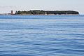
Ruden island from the southeast
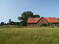
The island farm on the Ruden

View of the tower from W - a small exhibition inside

Ruden - flak position (front), pier with cormorants

Lotsenturm auf dem Ruden from 1903, now a monument, is to be restored
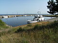
Port of the island of Ruden
View from the tower in south direction

View from Koserow to the Ruden and the "Rügen Alps"


literature
- Joachim Blüthgen: Greifswalder Oie and Ruden . (= Supplement No. 248 to Petermanns Geographische Mitteilungen ). Gotha 1952.
- Lutz Mohr : Between Ryck and Ruden . The socialist structure of our homeland using the example of the “Bruno Leuschner” nuclear power plant ... and the “Friedrich Loeffler Institute”. Riems Island - Bodden Islands as reflected in history. (= New Greifswald Museum Issues . No. 3). City Museum, Greifswald 1978.
- Lutz Mohr: The island of Ruden - a delightful piece of Western Pomerania earth . In: Vorpommern-Blitz, vol. 11, edition of October 28, 2001, p. 13
- Heinrich Berghaus : Land book of the Duchy of Pomerania and the Principality of Rügen. IV. Part, Volume II, Anklam 1868, p. 1039 f.
Web links
- Literature about Ruden (island) in the state bibliography MV
- History of rowing ( Memento from February 11, 2013 in the web archive archive.today )
Individual evidence
- ^ Manfred Niemeyer: Ostvorpommern. Collection of sources and literature on place names. Volume 2: Mainland. (= Greifswald contributions to place name studies. Volume 2). Ernst Moritz Arndt University of Greifswald, Institute for Slavic Studies, Greifswald 2001, ISBN 3-86006-149-6 , p. 116.
- ↑ Der Ruden - Traditional Western Pomeranian pilot island . Axel-Dietrich-Verlag, Peenemünde 1993, ISBN 3-930066-01-7 .
- ^ Manfred Niemeyer: Ostvorpommern. Collection of sources and literature on place names. Volume 2: Mainland. (= Greifswald contributions to place name studies. Volume 2). Ernst Moritz Arndt University of Greifswald, Institute for Slavic Studies, Greifswald 2001, ISBN 3-86006-149-6 , p. 116.
- ↑ a b c Friedrich-Wilhelm Dwars: The alleged land connection between Rügen and Ruden in historical times and the emergence of the driveways on the eastern edge of the Greifswald Bodden. In: Baltic Studies . Volume 45 NF, 1958, ISSN 0067-3099 , pp. 9-26.
- ↑ Nils Petzholdt: The Mönchgraben near Baabe and the land connection between Rügen and the Ruden In: Pommern. Journal of Culture and History. Issue 1/2014, ISSN 0032-4167 , pp. 4–8./ Nils Petzholdt: The Mönchgraben near Baabe and the land connection between Rügen and Ruden In: Stralsund Hefte for history, culture and everyday life, Stralsund 2014, ISBN 978-3941444928 , Pp. 94-99.
- ↑ Leo Schmidt , Uta Mense: Monument landscape Peenemünde. A Scientific Inventory - Conservation Management Plan. Ch. Links Verlag, Berlin 2013, ISBN 978-3-86153-718-2 , p. 65.
- ^ Island registration point Ruden. (No longer available online.) State association of Buckfastimker Mecklenburg-Vorpommern eV, archived from the original on March 29, 2013 ; Retrieved August 3, 2013 . Info: The archive link was inserted automatically and has not yet been checked. Please check the original and archive link according to the instructions and then remove this notice.
- ↑ official website of the Usedom Nature Park
- ↑ Anke Lübbert: In the intoxication of loneliness. The Ruden is a tiny island between Rügen and Usedom. Katharina Weit has been guarding the island for six months, counting birds, otters, seals. And can hardly believe her happiness in the silence . In: Frankfurter Rundschau of March 8, 2019, pp. 20–21.
- ↑ Peenemünde: Valuable nature reserve secured for the future. (PDF) DBU Naturerbe, January 5, 2012, accessed on May 15, 2016 .
- ↑ Ruden island inhabited again: Jordsand takes care of it. Deutsche Bundesstiftung Umwelt , December 21, 2015, accessed on May 15, 2016 .
- ↑ No operating license for the port of Ruden Island. (No longer available online.) Kröslin parish , March 24, 2016, archived from the original on May 15, 2016 ; accessed on May 15, 2016 . Info: The archive link was inserted automatically and has not yet been checked. Please check the original and archive link according to the instructions and then remove this notice.

Ahrendsberg | Balmer Werder | Barther Oie | Baumwerder | Beuchel | Buck | Bull reef | Böhmke | Brinkenberg | Dänholm (near Kröslin) | Dänholm (near Stralsund) | Ferry Island | Fehmarn | Gänsewerder | Görmitz | Greifswalder Oie | Big Werder | Big Wotig | Grot Deil | Hay meadow | Hiddensee | Kastenwerder | Kiel place | Kirr | Small pipe plan | Little Werder | Little Wotig | Little Werder | Kohlhof Island | Koos | Langenwerder | Dear | Liebitz | Moravia | Oe | Poel | Prosnitzer Werder | Riems | Riether Werder | Reefbrink | Ruden | Rügen | Tedingsinsel | Tollow | Ummanz | Urkevitz | Usedom | Vilm | Bird Island | Whale | Warder | Willow tail | Werder | Wührens