
Karlshagen
| coat of arms | Germany map | |
|---|---|---|

|
Coordinates: 54 ° 7 ' N , 13 ° 50' E |
|
| Basic data | ||
| State : | Mecklenburg-Western Pomerania | |
| County : | Vorpommern-Greifswald | |
| Office : | Usedom-North | |
| Height : | 3 m above sea level NHN | |
| Area : | 5.07 km 2 | |
| Residents: | 3197 (Dec. 31, 2019) | |
| Population density : | 631 inhabitants per km 2 | |
| Postal code : | 17449 | |
| Area code : | 038371 | |
| License plate : | VG, ANK, GW, PW, SBG, UEM, WLG | |
| Community key : | 13 0 75 058 | |
| Office administration address: | Möwenstrasse 1 17454 Zinnowitz |
|
| Website : | ||
| Mayor : | Sven Käning | |
| Location of the municipality of Karlshagen in the Vorpommern-Greifswald district | ||
  |
||

Karlshagen is a seaside resort in the Vorpommern-Greifswald district in Mecklenburg-Western Pomerania . It belongs to the Usedom-Nord office with its seat in Zinnowitz .
geography
Karlshagen is located in the north of the island of Usedom between Trassenheide and Peenemünde .
history
To 1900
As a result of the flourishing of the Hammelstall colony (later Trassenheide), the associated fishing colony, later Karlshagen, was segregated in 1829 with 27 places to live. The place was named Carlshagen in 1836 when it was first mentioned in a document, whereby the name was chosen in honor of the Szczecin government councilor Carl Triest , who had made a name for himself in the independence of the settlement.
While only half a dozen buildings were to be seen in the PUM (Preussisches Urmestischblatt) of 1835 on the way to Peenemünde, the settlement of Karlshagen in the Mes Tischblatt (MTB) had grown considerably in 1880. From the cemetery to the “Forsthaus Scheide” there was a closed place along the road with branches in the direction of Peenestrom. On the beach there were only the boat place and the fishermen's sheds, but also a restaurant "beach hall", as well as a ladies' and a gentlemen's pool.
Around 1865 the place had 307 inhabitants, who lived mainly from fishing.
In 1885 a pier was built in Karlshagen . In 1912 the place got its own church .
1900 until today


After the MTB 1920, the settlement of Karlshagens on the street and further in the direction of Peenestrom, almost all buildings were south of the street, only the newly built church was to the north of it. It was not until after 1990 that a district called "Seebad Karlshagen" emerged beyond the forest and the wide dune landscape on the beach.
Karlshagen was in the restricted area of the Peenemünde Army Research Center (HVA) from 1939 to 1945 . In the 1930s a housing estate was built for the executives, scientists, technicians and workers of the HVA. Although the settlement was largely destroyed in the air raids in 1943/44, some streets with the houses are still preserved. The road and railway line to Peenemünde ran between the northern and southern part of the settlement . The Karlshagen-Siedlung train station was located there. This was connected to both parts of the settlement by a long, paved tunnel, which also served as an air raid shelter. S-Bahn trains ran here at frequent intervals between Karlshagen and Peenemünde. The Wehrmacht camp and the prison camps were also accessible by S-Bahn.
During the Second World War there were several forced labor camps in the restricted area . These were mainly in the Peenestraße in Karlshagen a "Polish camp", a POW camp for Soviet and sometimes French prisoners and a camp for easterners and between Karl Hagen and Trassenheide the communal Trassenheide , in the next German, Italian and Dutch contract workers and hundreds of Ukrainians and Poles ( " Poland Camp II ”) were housed. From 1943, there were also two satellite camps of the Ravensbrück concentration camp with concentration camp prisoners in the actual Peenemünde military estate district . Many of them died in the bombing raid on Peenemünde and Karlshagen in August 1943 ( Operation Hydra ). The aim of the bombing raids on Karlshagen was actually to eliminate the HVA's elite. In total, more than 720 people died in the attacks, including 213 slave laborers. After the bombing, the surviving prisoners were immediately used for cleanup and reconstruction work.

Housing estate of the HVA before the bombing in 1943

Housing estate of the HVA after the bombing in 1943

Station tunnel and air raid shelter

Karlshagen memorial and memorial
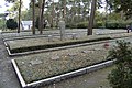
Grave fields in the memorial


A reminder and memorial for prisoners of war , concentration camp inmates and forced laborers who were used to build the V1 and V2 rockets in nearby Peenemünde has been located not far from the exit sign in the direction of Trassenheide since 1971 .
During the Soviet Occupation Zone and the GDR , the area northwest of Karlshagen, including the village of Peenemünde, was still a restricted area, first for the Soviet Army and then for the NVA . The barrier with guard 1 was at the northwest exit of Karlshagen, where it was at the time of the HVA.
Until the fall of the Wall, one of the largest children's camps in the GDR was located in the southeast of Karlhagen near Trassenheide. The area was newly developed with a spa center.
Karlshagen has been a state-approved resort since 1997, and in 2001 it was named "Ostseebad Karlshagen".
Karlshagen has belonged to the Prussian province of Pomerania since it was founded and was part of the Usedom-Wollin district from 1818 to 1945 . From 1945 to 1952, the part of the district that remained in Germany after the Second World War formed the district of Usedom, which in 1952 became part of Wolgast in the Rostock district. The community has belonged to the state of Mecklenburg-Western Pomerania since 1990 and to the district of East Western Pomerania since 1994 . This opened in 2011 in the district of Vorpommern-Greifswald .
Population development
|
|
Status: December 31 of the respective year
politics
Community representation
The municipal council of Karlshagen consists of 11 members and the mayor. The local elections on May 26, 2019 led to the following result with a turnout of 64.5%:
| Party / group of voters | be right | Seats |
| The left | 31.4% | 4th |
| Initiative for Karlshagen | 23.4% | 3 |
| Single applicant Sven Käning | 21.9% | (3) |
| Citizens for Karlshagen | 20.5% | 3 |
| SPD | 2.8% | 1 |
Sven Käning's share of the vote corresponds to three seats. He ran as both a community representative and mayor. Since he accepted the election as mayor, three seats in the municipal council remain vacant according to Section 65 (6) of the State and Local Election Act.
mayor
- 1991–1994: Ewald Bluhm
- 1994–2014: Marlies Seiffert (Die Linke)
- 2014–2019: Christian Höhn (initiative for Karlshagen)
- since 2019: Sven Käning
Käning was elected in the mayoral election on June 16, 2019 with 60.2% of the valid votes.
coat of arms
|
|
Blazon : “Divided by a wave cut; above in blue a left-flying silver seagull with a golden beak; a blue fishing net in silver below. "
The coat of arms was designed by Roland Bornschein (Wismar). It was approved on February 2, 1999 by the Ministry of the Interior and registered under the number 180 of the coat of arms of the state of Mecklenburg-Western Pomerania. |
| Justification of the coat of arms: The wave cut and the seagull in the coat of arms are intended to symbolize the location of the seaside resort on the Baltic Sea. The fishing net refers on the one hand to the origin of the place, the fishing colony, and on the other to fishing, the former main livelihood of the inhabitants. The tinging refers to the affiliation of the municipality to the part of Western Pomerania. |
flag

The flag is evenly striped lengthways in white and blue. In the middle of the flag is the municipal coat of arms, two thirds of the height of the white and blue stripes. The relation of the height of the flag cloth to the length is like 3: 5.
Official seal
The official seal shows the municipal coat of arms with the inscription "GEMEINDE OSTSEEBAD KARLSHAGEN".


Attractions

- Karlshagen Church; The Protestant parish has been a member of the Cross of Nails Community since March 2009, which arose from the Coventry Cross of Nails campaign
- Promenade square with concert pavilion and central bronze sculpture
- Karlshagen memorial to remember the victims of the Second World War and the fate of the concentration camp inmates interned in Peenemünde
- Marina Karlshagen with hotel and dining facilities
Economy and Infrastructure
110 kV line
Between Peenemünde and Karlshagen, a two-circuit 110 kV three-phase overhead line crosses the Peenestrom, the 75 meter high masts of which are visible from afar. The line was built in the early 1950s to carry the electricity generated in the Peenemünde coal-fired power station , most of which was no longer needed on Usedom after the Army Research Institute was closed, to the mainland. A branch line to the Karlshagen substation was later built from this line.
After the Peenemünde power plant was shut down in 1990, the 110 kV overhead line from the branch of the branch line to Karlshagen to the Peenemünde power plant was dismantled, so that the 110 kV three-phase current line across the Peene only feeds the Karlshagen substation.
traffic
Karlshagen is on the L 264 state road between Peenemünde and Trassenheide .
Karlshagen station is on the Zinnowitz – Peenemünde line . It is served by the regional train line RB 24 (Zinnowitz – Peenemünde).
Tourism and sport
Tourism is of considerable importance for Karlshagen. In 2019 the place had 3751 guest beds and in 2019 recorded 569,594 overnight stays in the tourist tax period. Over 70 percent of the guests came from the new federal states .
Immediately near the beach behind the dunes, in the dune forest, the dune camp is a year-round camping site with a capacity of around 340 parking spaces. On the east bank of the Peene River is one of the main marinas Usedoms with 112 moorings.
Cycle paths lead from the marina to Peenemünde with the dike, Peeneblick, ruins of the Peenebunker, Kämmerersee and from Peenemünde in the direction of Karlshagen with the forester's house, the Alte Wache ruins, the original station for the factory railway, the loading area for building materials from the HVA and the remaining development of the HVA housing estate with a station tunnel
Since 2000, the Usedom Beach Cup, one of the largest beach volleyball tournaments in Europe, has been held every year on the beach at the Baltic Sea resort.
Web links
Individual evidence
- ↑ Statistisches Amt MV - population status of the districts, offices and municipalities 2019 (XLS file) (official population figures in the update of the 2011 census) ( help ).
- ↑ Manfred Niemeyer: Ostvorpommern I . Collection of sources and literature on place names. Vol. 1: Usedom. (= Greifswald contributions to toponymy. Vol. 1), Ernst-Moritz-Arndt University of Greifswald, Institute for Slavic Studies, Greifswald 2001, ISBN 3-86006-149-6 . P. 23 ff
- ^ Heinrich Berghaus : Land book of the Duchy of Pomerania and the Principality of Rügen . Vol. 1, W. Dietze, Anklam-Berlin 1865, pp. 468-469.
- ↑ Population development of the districts and municipalities in Mecklenburg-Western Pomerania (Statistical Report AI of the Statistical Office Mecklenburg-Western Pomerania)
- ^ Result of the local election on May 26, 2019
- ↑ State and Local Election Act
- ↑ Chronicle of Karlshagen after 1990 on www.heimatverein-karlshagen.de
- ^ Result of the mayoral election on May 26, 2014
- ^ Result of the mayoral election on June 16, 2019
- ↑ Hans-Heinz Schütt: On shield and flag production office TINUS, Schwerin 2011, ISBN 978-3-9814380-0-0 , p. 363/364.
- ↑ a b Main statutes of the Ostseebad Karlshagen community, § 1 (PDF).
- ↑ www.nagelkreuzgemeinschaft.de ( memento from July 30, 2013 in the Internet Archive ) accessed April 20, 2009
- ↑ a b www.karlshagen.de accessed June 20, 2020
Ahlbeck | Old Tellin | Altwarp | Altwigshagen | Anklam | Bandelin | Bargischow | Behrenhoff | Bentzin | Benz | Mountain wood | Blankensee | Blesewitz | Boldekow | Boock | Brietzig | Brünzow | Bugewitz | Buggenhagen | Butzow | Daberkow | Dargelin | Dargen | Dersekow | Ducherow | Eggesin | Fahrwalde | Ferdinandshof | Garz | Glazov | Görmin | Grambin | Grambov | Greifswald | Gribow | Gross Kiesow | Groß Luckow | Great Polzin | Gützkow | Hammer ad Uecker | Hanshagen | Heinrichswalde | Heringsdorf | Hinrichshagen | Hintersee | Iven | Jarmen | Jatznick | Comb teeth | Karlsburg | Karlshagen | Katzow | Kemnitz | Klein Bünzow | Koblentz | Korswandt | Koserow | Krackow | Krien | Kröslin | Kruckow | Krugsdorf | Krummin | Krusenfelde | Lassan | Leopoldshagen | Levenhagen | Liepgarten | Löcknitz | Loddin | Loissin | Loitz | Lubmin | Luebs | Luckow | Luetow | Medow | Meiersberg | Mellenthin | Mesekenhagen | Mölschow | Mönkebude | Murchin | Nadrensee | Neetzow-Liepen | New Boltenhagen | New Kosenow | Neuenkirchen | Neuenkirchen | Low | Papendorf | Pasewalk | Peenemünde | Penkun | Plow | Polzow | Postlow | Pudagla | Ramin | Rankwitz | Rollwitz | Rossin | Rossow | Rothemühl | Rothenklempenow | Rubenov | Rubkov | Sarnow | Sassen-Trantow | Sauzin | Schmatzin | Schönwalde | Spantekow | Stumble on the Peene | Stolpe on Usedom | Strasburg (Uckermark) | Torgelow | Trassenheide | Tutow | Ückeritz | Ueckermünde | Usedom | Square | Vogelsang-Warsin | Völschow | Wackerow | Weitenhagen | Wilhelmsburg | Wolgast | Wrangelsburg | Wusterhusen | Zemitz | Zempin | Zerrenthin | Ziethen | Zinnowitz | Zirchow | Züssow