
Mellenthin
| coat of arms | Germany map | |
|---|---|---|

|
Coordinates: 53 ° 55 ' N , 14 ° 1' E |
|
| Basic data | ||
| State : | Mecklenburg-Western Pomerania | |
| County : | Vorpommern-Greifswald | |
| Office : | Usedom-South | |
| Height : | 20 m above sea level NHN | |
| Area : | 19.25 km 2 | |
| Residents: | 436 (Dec. 31, 2019) | |
| Population density : | 23 inhabitants per km 2 | |
| Postal code : | 17429 | |
| Area code : | 038379 | |
| License plate : | VG, ANK, GW, PW, SBG, UEM, WLG | |
| Community key : | 13 0 75 090 | |
| Community structure: | 3 districts | |
| Office administration address: | Markt 1 17406 Usedom |
|
| Mayor : | Bernd Meier | |
| Location of the municipality of Mellenthin in the Vorpommern-Greifswald district | ||
  |
||


Mellenthin is a municipality near the town of Usedom on the island of the same name . It is administered by the Usedom-Süd office based in the city of Usedom. Until December 31, 2004 the community belonged to the office at Schmollensee . On January 1, 2005, the municipalities of Mellenthin and Morgenitz were dissolved and since then together they have formed the new municipality of Mellenthin.
Geography and traffic
Mellenthin is located in the interior of the island of Usedom six kilometers north of the Szczecin Lagoon on the federal roads B 110 and B 111 on the northern edge of the Mellenthiner Heide , which is part of the island of Usedoms nature park . The village is located in a scenic region five kilometers southwest of the Schmollensee and just as far south of the Achterwasser , southeast of the Lieper Winkel and east of the Peenestrom . The town of Usedom is ten kilometers southwest of the municipality and the seaside resort of Bansin is eleven kilometers north .
The next train stop is Schmollensee on the Heringsdorf – Wolgast railway line , nine kilometers north of Mellenthin.
Districts
|
|
The community has belonged to the state of Mecklenburg-Western Pomerania since 1990. Since 1994 it has belonged to the district of Ostvorpommern , which became part of the Vorpommern-Greifswald district in 2011 .
history
Dewichow
In the Krienker See, across from Dewichow, is the island of Werder. A late Slavic settlement was archaeologically established on it. This is proven by the Slavic foundation of Dewichow.
Dewichow was first mentioned in 1319 as "Diwachow". The Slavic founding name is only associated with a personal name.
The estate was built before 1880 and is only partially preserved. The park disappeared after the war. Two post mills stood in a south-easterly direction away from the village, but they disappeared after 1920.
Dewichow was a manor village with a dominant manor and farm workers' cottages. Just to the south there was a residential area with what was probably a farmstead. The shape of the village has changed in the present. After the war and the land reform, small rural farms emerged, which gave the place the shape of a street village along the road.
Mellenthin
The area of Mellenthin was settled at an early age, as can be seen from early and prehistoric finds. From the 7th to the 10th century, the Slavs from the Liutizen tribe built a strong hill fort here. The dating ceramic finds are of the Feldberg, Menkendorf and Freesendorf types, other finds are more difficult to date. About one kilometer north of Mellenthin are the well-preserved remains of the early Slavic hill fort. The castle is now also known as the "Schwedenschanze" and is located in the so-called "Borgwald". The castle wall, built on a high natural sand dune (Os), has a pointed oval shape and extends over an area of around 5 hectares. The heights of the ramparts vary between 2 m and 5 m. The castle served, among other things, as a place of retreat (refuge) for people and cattle. The facility with a diameter of 250 meters in the oak forest can still be clearly seen on the hiking trail through today's Mellenthiner Os nature reserve .
The early German period from 1230 is documented by a tower hill next to the current castle grounds. This tower hill castle was followed by the fortified courtyard with a moat, the forerunner of the later and current moated castle.
The village was first mentioned in 1270 as "Mildotitz". In this document of March 15 of that year, the Bishop of Cammin , in whose possession Mellenthin was, exchanged this village with five other communities on Usedom ( Ückeritz , Balm , Loddin , Suckow) at the request of Duke Barnim I of Pomerania-Stettin and Krienke ) against Damerow in Western Pomerania (near today's Nowogard ), which had belonged to the Premonstratensian monastery Grobe near the city of Usedom ; In 1309 this moved to Pudagla . The Slavic name is interpreted as "small".
In 1336 representatives of the noble family of Neuenkirchen were first mentioned in Mellenthin. The place was until the death of the ducal-Pomeranian councilor Christoph von Neuenkirchen (1567–1641), with whom the male family died out, their main residence on the island of Usedom. Christoph's father, Rüdiger von Neuenkirchen, had the moated castle, which still exists today, built in the Renaissance style from 1577 to 1580 . At some distance from this are the remains of the medieval defense tower.
After the Swedes, together with the whole of Western Pomerania, also received the island of Usedom in the Peace of Westphalia in 1648 , General Burchard Müller von der Lühne , who was ennobled in the Swedish service, became the new owner of Mellenthin Castle in 1650, which included the largest aristocratic manor on the island of Usedom with the towns of Mellenthin , Neuhof, Neukrug and Gothen (today parts of Heringsdorf ), Ahlbeck (partially), Dewichow, Balm, Dargen and Waschensee belonged.
After the Treaty of Stockholm on February 1, 1720, Mellenthin, like the whole island, went from the Kingdom of Sweden to the Kingdom of Prussia.
Still owned by the Müller von der Lühne family, the Mellenthin estates were allodified in 1747 . Then the Prussian war council and chief magistrate von Verchen, Bleichert Peter von Meyenn , bought the Mellenthin manor complex for 69,000 Reichstaler. After the administrative reform in 1815, Mellenthin came to the Prussian province of Pomerania and belonged to the district of Usedom-Wollin from 1818 to 1945 . In 1817, the Mellenthin property was auctioned again because of over-indebtedness. On this occasion, the entire property was separated into two complexes, one of which kept its center in Mellenthin. This also included Dargen, Waschensee, Dewichow and Balm. The judiciary Wittchow became the new owner of this estate, and after his death the sons shared the inheritance again. The son Carl Wittchow received Mellenthin and Balm.
Mellenthin was a typical manor village, even if between the dominant manor, including the moated castle and the village with a farm workers' list, the church was on a kind of anger. In the middle of the Katenzeile was the manorial forestry. Around 1800 the farm yard in front of the castle had a U-shape, but around 1900 it expanded to a larger Y-shape.
In the period between the world wars, the Mellenthin manor was parceled out by a settlement company and divided into smallholdings. This created many settlement courtyards, so that the place expanded in the direction of Morgenitz and the junction on the B 110.
During this time, an ammunition depot for army artillery, the so-called Muna Mellenthin, was built in the Mellenthiner Heide . At the end of the Second World War , the bunkers were blown up. During the GDR era, the ammunition recovery and dismantling company was established there. It was continued after 1990 and takes care of ammunition remains, duds and other remnants of the war and the military installations (GSSD and NVA). Because of the ammunition dismantling and blasting, the area is largely designated as a restricted area.
After the end of the war, the Mellenthin Castle came into public use, various communal facilities of the community, including a kindergarten, were housed here. After privatization in 2001, the restoration of the complex began and a hotel was established.
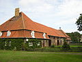
Of the farm buildings, only the large barn with storage is essentially left. This building has been extensively restored and expanded into a gastronomic facility as well as a holiday home.
From 1945 to 1952, the municipality and the part of the district of Usedom-Wollin that remained in Germany after the Second World War formed the district of Usedom in the state of Mecklenburg-Western Pomerania (until 1947) and then the state of Mecklenburg . This was in 1952 in the district of Wolgast in District Rostock on.
Morgenitz
Morgenitz was first mentioned in 1270 as "Murigneuitz". The name should be traced back to a personal name.
→ See main article: Morgenitz
- Karlsruh (desert)
Karlsruh was first mentioned in 1860 as "Carlsruhe". The name was not interpreted. In the table sheet MTB 1920 the living space appears as Vorwerk Karlsruh. The last official mention was made in 1925. However, the residential area will still have been inhabited. The ruins can still be seen in the satellite images.
- Palsin (desert)
Palsin was first mentioned in 1267 as "Paulzin". In it, Duke Barnim I confirms all of its possessions to the Grobe monastery, including Palsin. The place can no longer be located today, according to the information it was between Morgenitz and Mellenthin. An earlier document from 1239 (PUB I. No. 366) in which Palsin was mentioned, later turned out to be a forgery of the monastery, like many others from this time of this monastery.
There are currently no registered archaeological monuments in the area to confirm the location.
politics
coat of arms
|
|
Blazon : “In silver over a blue corrugated shield base with a silver crown, a red Renaissance castle with a wider three-storey central projectile and two three-storey side projections with pointed roofs and eight windows with daylight and an open arched door next to the central projectile; Above the side projections a slanted left and a slanted green oak leaf with an acorn. "
The coat of arms was designed by Andreas Meenke from Neubrandenburg . It was approved by the Ministry of the Interior on March 1, 2001 and registered under the number 237 of the coat of arms of the state of Mecklenburg-Western Pomerania. |
| Justification of the coat of arms: In the coat of arms, the castle and the base of the shield symbolize the renaissance castle that characterizes the village and is situated on an island surrounded by a wide moat. The oak leaves represent the extensive forest in the municipality. |
flag
The municipality does not have an officially approved flag .
Official seal
The official seal shows the municipal coat of arms with the inscription "GEMEINDE MELLENTHIN * LANDKREIS VORPOMMERN-GREIFSWALD".
Attractions
→ See: List of architectural monuments in Mellenthin
- The moated castle Mellenthin was partially restored at the beginning of the 21st century and is already a tourist attraction again, even if not all work has been completed.
- The former estate is a fully restored half-timbered building from the 16th century, which is now used as a restaurant with overnight accommodation, a porcelain exhibition and a sales point for sea buckthorn and other regional products.
- The Slavic ring castle is located 1.5 km northwest of Mellenthin in the 65 hectare nature reserve Mellenthiner Os , which was established in 1995. Hiking trails lead through oak forests and a former gravel pit pond with vegetation and deposits of sand martins .
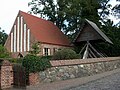
- The medieval brick church in Mellenthin has ribbed vaults in the choir and frescoes. The builder of the Mellenthin Castle, Rüdiger von Neuenkirchen , and his wife Ilsabe von Eickstädt are buried here.
- The main attraction of the Mellenthiner Heide hiking area south of the municipality is a bison reserve.
- The district of Dewichow 5 km northwest on Krienker See was first mentioned in 1319 as Diwachow . It is a former manor; the manor house is a single-storey building from the first half of the 19th century. A small settlement of holiday apartments has developed around this manor house. The hiking trail four kilometers east to the nature reserve of the Cosim peninsula and Lake Balmer is very popular. White- tailed eagles , white storks and gray herons can be found here.
- Tower hill "Eiskellerberg" Mellenthin
grange

Mellenthin Church
Morgenitz Church


Web links
- Literature about Mellenthin in the state bibliography MV
- Homepage of the municipality from the responsible office of Usedom-Süd
Individual evidence
- ↑ Statistisches Amt MV - population status of the districts, offices and municipalities 2019 (XLS file) (official population figures in the update of the 2011 census) ( help ).
- ↑ StBA: Changes in the municipalities in Germany, see 2005
- ↑ a b c d e Manfred Niemeyer: Ostvorpommern I . Collection of sources and literature on place names. Vol. 1: Usedom. (= Greifswald contributions to toponymy. Vol. 1), Ernst-Moritz-Arndt University of Greifswald, Institute for Slavic Studies, Greifswald 2001, ISBN 3-86006-149-6 . P. 11 ff
- ↑ Hans-Heinz Schütt: On shield and flag production office TINUS, Schwerin 2011, ISBN 978-3-9814380-0-0 , p. 441.
- ↑ a b main statute § 1 (PDF).
Ahlbeck | Old Tellin | Altwarp | Altwigshagen | Anklam | Bandelin | Bargischow | Behrenhoff | Bentzin | Benz | Mountain wood | Blankensee | Blesewitz | Boldekow | Boock | Brietzig | Brünzow | Bugewitz | Buggenhagen | Butzow | Daberkow | Dargelin | Dargen | Dersekow | Ducherow | Eggesin | Fahrwalde | Ferdinandshof | Garz | Glazov | Görmin | Grambin | Grambov | Greifswald | Gribow | Gross Kiesow | Groß Luckow | Great Polzin | Gützkow | Hammer ad Uecker | Hanshagen | Heinrichswalde | Heringsdorf | Hinrichshagen | Hintersee | Iven | Jarmen | Jatznick | Comb teeth | Karlsburg | Karlshagen | Katzow | Kemnitz | Klein Bünzow | Koblentz | Korswandt | Koserow | Krackow | Krien | Kröslin | Kruckow | Krugsdorf | Krummin | Krusenfelde | Lassan | Leopoldshagen | Levenhagen | Liepgarten | Löcknitz | Loddin | Loissin | Loitz | Lubmin | Luebs | Luckow | Luetow | Medow | Meiersberg | Mellenthin | Mesekenhagen | Mölschow | Mönkebude | Murchin | Nadrensee | Neetzow-Liepen | New Boltenhagen | New Kosenow | Neuenkirchen | Neuenkirchen | Low | Papendorf | Pasewalk | Peenemünde | Penkun | Plow | Polzow | Postlow | Pudagla | Ramin | Rankwitz | Rollwitz | Rossin | Rossow | Rothemühl | Rothenklempenow | Rubenov | Rubkov | Sarnow | Sassen-Trantow | Sauzin | Schmatzin | Schönwalde | Spantekow | Stumble on the Peene | Stolpe on Usedom | Strasburg (Uckermark) | Torgelow | Trassenheide | Tutow | Ückeritz | Ueckermünde | Usedom | Square | Vogelsang-Warsin | Völschow | Wackerow | Weitenhagen | Wilhelmsburg | Wolgast | Wrangelsburg | Wusterhusen | Zemitz | Zempin | Zerrenthin | Ziethen | Zinnowitz | Zirchow | Züssow