Szczecin Lagoon
|
Szczecin Lagoon Zalew Szczeciński |
|
|---|---|
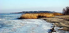
| Coast near Trzebież | |
| ocean | Atlantic Ocean |
| location | Poland , Germany |
| Tributaries | Or , Wkra , Gowienica , Zarow , Świna |
| Affiliated seas | Pomeranian Bay |
| Important islands | Chełminek , Wichowska Kępa , Łysa Wyspa , Groß Bockkamp |
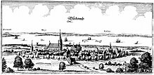
| Cities on the shore | Trzebież , Nowe Warpno , Świnoujście , Wolin , Stepnica , Ueckermünde , Usedom |
| Data | |
| surface | 700 km² |
| Maximum depth | 11 m |
| Middle deep | 4 m |
| Satellite image | |
Coordinates: 53 ° 47 ′ 0 ″ N , 14 ° 20 ′ 0 ″ E


The Szczecin Lagoon ( Polish Zalew Szczeciński ), also Oderhaff and Pommersches Haff called an inner coastal waters in the mouth area of Or and the Peene , is the second largest lagoon ( lagoon ) of the Baltic Sea .
With all its tributaries, the Szczecin Lagoon has an extension of 903 km² , an east-west extension of 52 kilometers and a north-south extension of 22 kilometers. It has an average depth of 3.8 meters. The largest natural depths are 8.5 meters, while the sea route between Stettin (Szczecin) and Swinoujscie (Świnoujście) is 10.5 meters deep. The Curonian Lagoon near Klaipėda (Memel) in Lithuania is larger than the Szczecin Lagoon with 1584 km², while the Fresh Lagoon near Kaliningrad and Elbląg is smaller with 840 km².
geography
The state border between Poland and Germany has run through the lagoon since 1945 . The Polish part to the east of the state border is known as the Großes Haff , the western German part as the Kleines Haff . The Große Haff has an area of 410 km² with a volume of 1.6 km³ while the Kleine Haff is about 277 km² with a volume of 1 km³. Upstream are the islands of Usedom , Wolin (Wollin) and Karsibór (Kaseburg). The connection between the Stettiner Haff and the open Baltic Sea is formed around the islands of Usedom and Wolin by the inlets Dziwna (Dievenow), Swine and the Peenestrom . From the land side, the Peene , Zarow , Uecker , Gowienica (Gubenbach) and the Oder near Stettin flow into the lagoon. The banks are mostly flat and overgrown with reeds, only in a few places, such as at Kamminke , at Repziner Haken at Altwarp or at Lubin (Lebbin) are there cliffs.
The southern part of the Szczecin Lagoon belongs with its waterside area to urban area of the metropolis Szczecin .
Cities
Clockwise:
- Swinoujscie ( Świnoujście )
- Wolin
- Stepnica
- Nowe Warpno
- Ueckermünde
- Usedom
Another important place is the large village of Trzebież ( goat town ) - a popular recreational area and border crossing .
Hydrography
The Stettiner Haff is only slightly salty with a salt content of 1 to 2.5 PSU ( practical salinity units ).
Emergence
The lagoon emerged from a glacier reservoir that was created by the compression moraines of the Vistula Ice Age on Usedom and Wolin. At that time, Peene and Ziese also functioned as melt water drains and flowed in the opposite direction to their current direction.
history
Fishing in the lagoon has always been an important branch of the economy for the surrounding settlements. The Wolgast Chancellor Henning von Ramin described the lagoon as "the Pom (m) erische Bergwerck". The income from fishing has been substantial and fishing rights have often been the source of disputes.
At the end of the 13th century, the city of Anklam established a customs post at the western end of the lagoon on the island of Anklamer Fähre . All ships that passed from the lagoon in the direction of Peenestrom had to pay a water tariff.
Duke Bogislaw X. of Pomerania issued a harbor regulation in 1495 to regulate the fishing industry. The waters had already been divided into districts (Kiepereien), which were administered by a Kieper, a ducal fishery overseer. The dukes were entitled to the so-called master fish ( salmon , sturgeon , carp and catfish ). Of the rest of the catch, it was the third or sixth part, depending on the region. Also in the chronicles of the 16th and 17th centuries, the waters called Freshness or Great Lagoon at that time were praised for their abundance of fish. At the beginning of the 17th century, Eilhard Lubinus described fishing with Zeesen boats and winter fishing with nets under the ice. In the 19th century and the beginning of the 20th century there were even up to 22 m long Zeese barges on the Szczecin Lagoon, which then fell victim to official regulations because the strong overfishing of the water at the time was at their expense. In Swedish Pomerania , a revised harbor regulation was issued in 1711 .
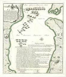
During the Seven Years' War , Prussia's first naval battle took place here on September 10, 1759 . After seven hours, the superior Swedish armed forces of the archipelago fleet, with 14 ships and 1,650 men , defeated the Prussian fleet of four Galiots , four galleys and four smaller ships at the narrowest point of the lagoon between the Woitziger and Repziner Haken could. The Prussian fleet withdrew after losing two galleys.
In the 1860s there were considerations to connect the island of Usedom to the Prussian railway network, which should take place via a railway embankment from Neuwarp to the southeast of Usedom. However, this project was discarded in favor of a swing bridge near Karnin .
The maritime shipping between the Szczecin Lagoon and the open Baltic Sea runs through the 1880 completed Channel "Kaiserfahrt" , today Piastenkanal , a navigation channel, some of which performs the Swine and originally belonging to Usedom Island Kaseburg has created.
nature
The south bank of the lagoon belongs to the Am Stettiner Haff nature park , the north bank with the island of Usedom belongs to the nature park Insel Usedom . West is the nature reserve Anklamer city break and in the Anklamer peat bog is a protected area, which after many years of use of peat in the restoration is. Because of the peat mining and economic use since the 16th century , the soil is now below sea level and was flooded in 1995 after a dike breached during storm floods. The rewetting as a moor or the renouncement of re-diking the former coastal flood moor leads to the clearly visible death of the trees of the former forest . The decision against commercial exploitation and in favor of renaturation within the framework of the Mecklenburg “moor protection program” is not without controversy in the region. At the same time, the open water areas offer a habitat and retreat for rare water birds.
The nature conservation project Peenetal -Landschaft and the nature reserve Unteres Peene valley (Peenetalmoor) are directly connected to this moor in the Peene area . Together they form the largest contiguous fen area in Central Europe .
Small parts of the lagoon are protected by the Wolin National Park.
See also
literature
- Haik Thomas Porada : The Pomeranian mine. The Bodden, Haffe and beach lakes of Pomerania in the princely rulership practice from the 15th to the early 17th century (contributions to Pomeranian regional, church and art history, vol. 13) , Thomas Helms Verlag , Schwerin 2009, ISBN 978-3-940207- 48-7 .
- Dirk Schleinert : The history of the island of Usedom . Hinstorff Verlag , Rostock 2005, ISBN 3-356-01081-6 .
Web links
proof
- ↑ a b ICZM-Oder Reports 14; Nardine Löser & Agnieszka Sekścińska: Integrated coast-river basin management on the Oder / Odra: Background report , 2005.
- ↑ http://www.ikzm-oder.de/steckbrief_hydrographie.html Hydrographic profile
- ^ Paul Friedeborn : Historical description of the city of old Stettin in Pomerania. Stettin 1613, p. 17f ( full text )
- ↑ Ulrich van der Heyden : Sea battle on the Stettiner Haff in 1759. Martenshagen 2016.
- ↑ Ulrich van der Heyden : The first Prussian sea battle on the Stettiner Haff in 1759. In: Baltic studies . Pomeranian Yearbooks for Regional History, NF, Vol. 103, Kiel 2018, pp. 105–135.
- ↑ Concept for the protection and use of the moors, State Government Mecklenburg-Western Pomerania, 2000/2009
- ↑ Renaturation: Climate Protection or Expropriation ?, NDR, April 10, 2013 ( Memento of April 14, 2013 in the Internet Archive )


