Or
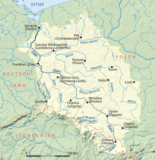
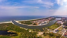
The Oder [ ˈʔoːdɐ ] ( Polish Odra ([ ˈɔ.dra ]), Czech Odra , Lower Sorbian Odra , Upper Sorbian Wódra , Silesian Ude ) is a central European river that originates in the Czech Republic, flows through Poland and part of the border between Poland and Germany forms. It flows through the Stettiner Haff and around the islands of Usedom and Wolin into the Baltic Sea . The Oder as a border river is a result of the Second World War . The Oder is 866 kilometers long (898 kilometers to Świnoujście (Swinoujscie) ).
Its tributaries include the Lusatian Neisse and the Warta , which are the longest tributaries and extend the length of the river system to 1045 kilometers . The mean discharge at the confluence with the Szczecin Lagoon is 574 m³ / s, making the Oder the fifth largest river in Germany after the Rhine , Danube , Inn and Elbe . Its catchment area is limited to the west and southwest by the Elbe, to the east by the Vistula and to the south by the Danube.
course

The source of the Oder is located in the Czech Republic one and a half kilometers northwest of Kozlov on Fidlův Kopec (Fiedelhübel) in the Moravian Oder Mountains . The first 31 kilometers of their run lead through the Libavá military training area . From its border, from the confluence of the Budišovka to Ostrava, it forms the historical provincial border between Silesia (on the left) and Moravia (on the right). At Bohumín the river crosses 195 m above sea level. at the confluence of the Olsa the border between the Czech Republic and Poland. The course of the river on Czech territory is 131 kilometers long and covers a catchment area of 10,288 square kilometers.
On its further course the Oder flows through Silesia and its capital Breslau (Wrocław) . From the mouth of the Neisse near Ratzdorf north of Guben in Brandenburg , its center to the junction of the West or north of Schwedt / Oder marks the border between Poland and Germany and is accordingly referred to as Grenzoder. The Oder flows through Frankfurt (Oder) , Słubice and Kostrzyn nad Odrą (Küstrin) . Between the cities of Lebus and Oderberg, the Oder flows through the almost 60 kilometers long and 12 to 20 kilometers wide Oderbruch , then passes the polder area near Schwedt, before it joins the two arms of Westoder at the Marienhof weir at river kilometer 704 . : Odra Zachodnia ) and Ostoder (Polish: Odra Wschodnia ) divides. The Westoder is a border river as far as Mescherin before it continues to flow like the Eastoder on both sides on Polish territory. The gradient of the last 30 kilometers before Stettin is only a few centimeters. From river kilometer 730.5, the Ostoder Große Reglitz (Polish: Regalica ) is called. At the height of the Dammschen Lake , the East and West Oder merge. As a so-called Pape water (Pol .: Roztoka Odrzańska ) flows or by Police (Pölitz) , before entering the the Baltic Sea belonging Szczecin Lagoon opens. The catchment area of the Oder covers 118,890 km². According to Polish law, the Or shall apply from the Hakenterrasse as internal marine waters and does not count on from there inland waters .
The border stretches of the Oder and Westoder are federal waterways of waterway class IV with a total length of 179 kilometers, for which the Eberswalde Waterways and Shipping Office is responsible.
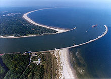
Since the Szczecin Lagoon is a bay, its three connecting arms to the open sea are inlets. As the estuaries of the Oder, they mainly carry Oder water to the north, but they also have a noteworthy influx of lake water into the lagoon, especially when there is a strong north wind. This can be seen from the delta formation on the back (haff side) , particularly pronounced in the swine. Location of these inlets and islands:
- Peenestrom (up to the confluence of the Peene river Der Strom ) between the German mainland and the island of Usedom (Polish: Uznam ),
- Świna (German Swine ) between the islands of Usedom and Wollin (Polish Wolin ), with the shipping route, Kanał Piastowski , until 1945 Kaiserfahrt , built 1875 to 1880,
- Dziwna (German Dievenow ) between the island of Wollin and the Polish mainland.
15% of the total discharge of the Oder takes place via the Peene River, 73% via the Swine and 12% via the Dziwna.
Shipping
The Oder is navigable for 717 kilometers to Koźle (German Cosel ) in Poland. This is where the Gleiwitz Canal connects , which was intended to be the beginning of the Danube-Oder Canal .
By straightening the Oder, which is navigable for seagoing vessels from the Baltic Sea upriver through the Stettiner Haff to Stettin (Szczecin) , has been shortened from 1,040 kilometers to 866 kilometers since around 1850.
The river was largely canalized in two phases: 1888–1897 and 1907–1922. In order to make the river navigable for larger ships, barrages and sluices were built, whereby the water power was also used to generate electricity at the barrages. There are currently seven hydropower plants in operation, the largest belonging to the Brzeg Dolny barrage and an output of 9.7 MW.
Since July 2007, after 62 years, an occasional ferry has been operating between the German town of Güstebieser Loose and the Polish town of Gozdowice (German: Güstebiese). A motor ship with a paddle wheel drive serves as the vehicle .
High and low water events
Extreme events in the 20th and 21st centuries
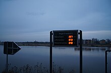
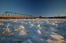
1997 saw the largest flood of the Oder to date . Most recently, in May 2010, the Oder burst its banks in many places in Poland and Germany. In the lower part of the Oder (e.g. Hohensaaten) the ice floods dominate.
| maximum water level in cm |
date |
|---|---|
| 717 | July 24, 1997 |
| 655 | August 30, 1854 |
| 653 | May 28, 2010 |
| 651 | November 6, 1930 |
| 638 | March 23, 1947 |
| 621 | July 21, 1903 |
| 620 | January 27, 1907 |
| 618 | August 31, 1977 |
| 612 | September 10, 1938 |
| 611 | March 22, 1940 |
Selection of flood events
July / August 1496, August 1501 (in parts), August / September 1515, March 1565, July 1675, March / April 1698, March / April 1709, June / July 1736, April 1785, August / September 1813, March 1830, September 1831, March 1838 (in parts), August / September 1854, February / March 1876, March 1891, June / July 1902, July 1903, October 1915 (in parts), June 1926, October / November 1930, March / April 1940, March / April 1947 , January 1982 (extreme damming due to ice on the lower reaches), July / August 1997 , May / June 2010 .
Selection of low water events
1473, 1590, 1616, 1719, September / October 1811, October 1824, October 1834, September 1835, September 1842, July to October 1893, July to October 1904, July to October 1911, July to November 1921, June / July 1922, June / July / August 1930, May to August 1934, July / August / September 1935, July to October 1992, June to October 2003, August to November 2004, July / August 2006, July to November 2015 and since July 2018
Environment and nature protection
In 1996, Germany, Poland and the Czech Republic founded the “ International Commission for the Protection of the Oder against Pollution ” (IKSO). In the agreement, the states committed to an immediate program to reduce the pollution of the Oder and its catchment area. One of the measures that followed is, for example, the construction of jointly used sewage treatment plants.
The Lower Oder Valley National Park, founded in 1995, is of particular importance for nature conservation on the Oder . The Oder is part of the Living Rivers campaign run by Deutsche Umwelthilfe . This campaign works nationwide to ensure that rivers and streams are transformed back into natural landscapes.
Political importance
Through the first paragraph of Article 331 of the Versailles Peace Treaty , the Oder was declared an international river from the inflow of the Oppa, together with the Elbe, Memel and Danube. The Oder was placed under the administration of the International Oder Commission . This commission consisted of one representative each from Poland , Prussia , Czechoslovakia , the United Kingdom , France , Denmark and Sweden .
The Oder gained renewed political importance after the end of the Second World War . As part of the Potsdam Agreement in 1945, around a quarter of the German state territory was de facto separated within the borders of 1937 and placed under provisional Polish or Soviet administration. In 1990 the Oder-Neisse line was confirmed as the German eastern border when the Federal Republic of Germany waived all claims to formerly German areas east of this line in the Two-Plus-Four Treaty and the German-Polish Border Treaty .
Surname
- The Latin name Viadrus has not been handed down from antiquity, but was probably introduced - incorrectly - for the Oder by the Frankfurt professor Jodocus Willich in 1543. Unaware of his neo-Latin origins, he was also included in etymological speculations.
- Of the ancient authors, Pliny the Elder mention in his Naturalis historia and Pomponius Mela in De situ orbis only the Vistula from the tributaries of the Baltic Sea, Tacitus not a single Baltic Sea tributary in his Germania .
- In his Geographike Hyphegesis, Claudius Ptolemy locates three other rivers west of the Vistula that flow into the Baltic Sea. The geographical longitudes given by him allow a good relative localization of his names despite the differences in his graticule from today's. According to this, the Swine corresponds to a river called Συήβος ( Suebos , Latin: Suevus ). He does not give a source coordinate for this river, but mentions the Suebus when listing the peoples as the border between Semnonen and Burgundy inland, which corresponds to the use of the name for the Oder. Claudius Ptolemy locates a river called Οὐιαδούα (or Οὐιλδούα, graphic similarity of Α and Λ), in Latin Viadua or Vildua, between Suebos and Vistula, twice as far from the Vistula as from the Swine. Historians assume that this river corresponds to the Wieprza (Eng .: Wipper), which reaches the sea halfway between Swine and the former mouth of the Vistula.
- In Old Church Slavonic texts the river is called Vjodr .
- Latin documents of the Middle Ages unanimously call the river Oddara ( Adam of Bremen : Gesta Hammaburgensis ecclesiae pontificum ) or Oddera ( Dagome Iudex ). This corresponds to the current names in German (“Oder”, Silesian dialect also “Uder”) as well as in the Slavic languages: Czech Odra , Polish Odra ( Silesian dialect Uodra , Lower Sorbian Wodra , Upper Sorbian Wódra ).
- The name researcher Jürgen Udolph suspects the origin of the name from the Illyrian word Adra in the meaning of "water vein" with reference to a similar word in Sanskrit. Thus, avestisch adu- (as 'watercourse') would be conceivable as the original word. The idg. Word is also used in Thracian as urda "Strom, Bach". The German word "Ader" still meant not only "blood vessel" or "trickle" in Old High German, but also tendon , nerve and generally " gut ", similar to the ancient Greek word ήτορ (étor) "heart", "lung" or "soul" .
- Another, but rather folk etymological, attempt at explanation derives the name Oder / Odra from the Polish drzeć, przezierać , which means something like “tear, penetrate, push forward”, for example in the sense of “breakthrough to the sea”.
Tributaries

Downstream order
| Left tributaries | Right tributaries |
|---|---|
|
|
Alternatively: List sorted by state and alphabet
Channel connections
- Gliwice Canal : City of Gliwice
- Oder-Spree-Canal (section of the Spree-Oder waterway ): Oder - Canal - Spree - Canal - Dahme - Spree
- Warta - Nets - Kanał Bydgoski - Brda (Brahe) - Vistula
- Oder-Havel Canal (section of the Havel-Oder waterway ): Westoder - Hohensaaten-Friedrichsthaler Wasserstraße (canal parallel to the Oder) - Oderberg waters - Canal - Havel
- Finow Canal , still navigable predecessor of the Oder-Havel Canal
Regions
The Oder flows through or passes through these regions, among others:
- Country of Lebus
- Oderbruch
- Neumark (eastern part of Lebus, Polish Lubuskie )
- Neuenhagener Oderinsel
- Uckermark
- Lower Oder Valley National Park in the natural area "Lower Odertal Valley"
Localities

Main river
|
|
Stettiner Haff and estuary arms
- At the Stettiner Haff (Oderhaff):
- Wollin (Poland)
- Nowe Warpno (Neuwarp, Poland)
- Ueckermünde (Germany)
- At the Peenestrom :
- Usedom (Germany)
- Lassan (Germany)
- Wolgast (Germany)
- Peenemünde (Germany)
- At the Swine
- Świnoujście (Swinoujscie, Poland)
- At the Dievenow :
- Wolin (Wollin, Poland)
- Kamień Pomorski (Cammin, Poland)
- Dziwnów (Dievenow, Poland)

literature
- The Oder stream, its river basin and its main tributaries. A hydrographic, water management and water law representation. Published by the Bureau of the Committee for the Investigation of Flood Conditions. 3 volumes of text, 1 volume of map supplements, 1 volume of tables and attachments. Reimer, Berlin 1896.
- Jürgen Udolph , Wojciech Nowakowski: Or. In: Heinrich Beck, Dieter Geuenich, Heiko Steuer (Hrsg.): Reallexikon der Germanischen Altertumskunde. 2nd, completely revised edition, founded by Heinrich Beck, Herbert Jankuhn, Hans Kuhn and Reinhard Wenskus, edited by Rosemarie Müller, 35 volumes and 2 register volumes, Berlin / New York (1968–) 1973–2008, volume 21 ( 2002), pp. 546-549.
- Joachim Schneider: About the origin and variants of the river name Oder. In: Messages of the historical association to Frankfurt (Oder). 2003, H. 1, pp. 7-14.
- Uwe Rada : The Oder: the course of a river. 1st edition, Kiepenheuer, Berlin 2005, ISBN 3-378-01079-7 .
- Karl Schlögel, Beata Halicka (ed.): Oder-Odra: Views of a European river. Peter Lang, Frankfurt am Main 2007, ISBN 978-3-631-56149-2 .
- Karl Spiegelberg: The Oder River System. From the source to the lagoon. A European cultural landscape documented with scientific meticulousness. 2nd, expanded and improved edition, Viademica-Verlag, Berlin 2012, ISBN 978-3-939290-10-0 .
- Ludwig Zöller (Hrsg.): The physical geography of Germany. Scientific Book Society, Darmstadt 2017, ISBN 978-3-534-26868-9 , 6 River History of Central Europe - Change, Surprise, Crime. 6.6 Oder and Vistula system, pp. 139–141.
Web links
- Water level and flow indicator on Czech territory
- Water level and flow indicator on Polish and German territory
- WWF-Oder-Auen-Atlas
- The summer flooding of the Oder in 1997 (PDF; 6.54 MB)
- The summer floods of the Oder 2010 (PDF; 5.53 MB)
Individual evidence
- ↑ a b International Commission for the Protection of the Oder (IKSO): Internationale Flussgebietseinheit Oder , 2005, accessed on November 29, 2016.
- ↑ International River Basin District Or (PDF) report to the European Commission; 2005; On: ikzm-oder.de
- ↑ a b E. Niemirycz, T. Borkowski: Characterystyka jakości wód. W: Warunki środowiskowe polskiej strefy południowego Bałtyku. Gdańsk: Materiały Oddziału Morskiego IMiGW, 1995, s. 161-172
- ↑ Územní plán vojenského újezdu Libavá - změna č.1, veřejná část, p. 132 (PDF).
- ↑ Pramen Odry ( Memento from April 5, 2014 in the Internet Archive )
- ^ Federal Institute for Hydraulic Engineering (2014): Update of the flow control concept for the border or. Expert opinion, BAW no. 3.02.10132.3, p. 2 (PDF, wsa-eberswalde.de ).
- ↑ Directory E, serial no. 40 and 21 of the Chronicle ( Memento of the original from July 22, 2016 in the Internet Archive ) Info: The archive link was inserted automatically and has not yet been checked. Please check the original and archive link according to the instructions and then remove this notice. , Federal Waterways and Shipping Administration.
- ↑ Lengths (in km) of the main shipping lanes (main routes and certain secondary routes) of the federal inland waterways ( memento of the original from January 21, 2016 in the Internet Archive ) Info: The archive link was inserted automatically and has not yet been checked. Please check the original and archive link according to the instructions and then remove this notice. , Federal Waterways and Shipping Administration.
- ↑ Marc Feilbach: Draft of an integrated coastal zone management plan for the Oder estuary (PDF; 4.51 MB). ICZM-Oder Reports 2, 2004, p. 21.
- ↑ Informacje o Odrze i jej dorzeczu ( Memento of February 10, 2013 in the Internet Archive ) (Polish)
- ↑ German Hydrological Yearbook . Elbe region, part II. Havel with the German Oder region
- ↑ a b extreme events or: high water, low water. In: undine.bafg.de. Retrieved December 5, 2017 .
- ^ Karl Fischer: The summer floods of the Oder from 1813 to 1903 with special treatment of the floods from June / July 1902 and July 1903. In: Yearbook for the hydrology of northern Germany. Special messages. Volume 1, No. 6, Berlin 1907.
- ↑ Gustav Hellmann , Georg von Elsner: Meteorological studies on the summer floods of the Oder. Berlin 1911.
- ^ Heinrich Mann: The flood of August / September 1813. Its causes and its course. In: Yearbook for the hydrology of northern Germany. Special messages. Berlin 1905.
- ↑ No ship sails anymore Or reaches a new low In: rbb24.de , July 30, 2018, accessed on July 31, 2018.
- ↑ a b c Case Relating to the Territorial Jurisdiction of the International Commission of the River Oder. (Series A No 23 -Series C No 17-11) / Judgment of September 10th, 1929. In: http://www.internationalwaterlaw.org/ . International Water Law Project, accessed October 24, 2010 .
- ↑ Joachim Schneider, 2003, p. 14.
- ^ Claudius Ptolemaios: Geographike Hyphegesis , chap. 11: Germania Magna . (ancient Greek / Latin / English)
- ↑ Ralf Loock: Mouths of the rivers determined. In: Märkische Oderzeitung , Frankfurt 2008, 3 (March); Ralf Loock: Name thriller about Viadrus in: Märkische Oderzeitung - Journal. Frankfurt 25./26. November 2006, p. 2; see also Alfred Stückelberger , Gerd Graßhoff (Ed.): Ptolemaios - Handbook of Geography. Schwabe, Basel 2006, ISBN 3-7965-2148-7 , p. 223
- ↑ Encyclopædia Britannica 9th edition 1870–1890: Or &
- ↑ Monumenta Germaniae Historica: Res gesta Hammaburgensis ecclesiae, p. 76
- ↑ Jürgen Udolph, Wojciech Nowakowski: Or. In: Heinrich Beck, Dieter Geuenich, Heiko Steuer (Hrsg.): Reallexikon der Germanischen Altertumskunde. 2nd, completely revised edition, edited by Rosemarie Müller. 35 volumes and 2 register volumes, Berlin / New York (1968–) 1973–2008, Volume 21, 2002, pp. 546–549.
- ↑ Kluge: Etymological Dictionary of the German Language , 24th edition, 2002
- ↑ Langenscheidt's pocket dictionary of ancient Greek , 8th edition, 2000
- ↑ Uwe Rada: The Oder. Life course of a river. Kiepenheuer, Berlin 2005, ISBN 3-378-01079-7 , p. 15.
