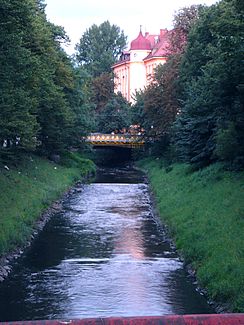
Klodnitz
|
Klodnitz Kłodnica |
||
|
The Klodnitz in Gliwice |
||
| Data | ||
| location | Upper Silesia ( Silesian and Opole Voivodeship ), Poland | |
| River system | Or | |
| Drain over | Or → Stettiner Haff | |
| source | near Murcki (Emanuelssegen) 50 ° 12 ′ 30 ″ N , 19 ° 1 ′ 53 ″ E |
|
| muzzle | south of Koźle (Cosel) in the Oder Coordinates: 50 ° 19 ′ 46 ″ N , 18 ° 9 ′ 43 ″ E 50 ° 19 ′ 46 ″ N , 18 ° 9 ′ 43 ″ E
|
|
| length | 76 km | |
| Right tributaries | drama | |
| Reservoirs flowed through | The large Dzierżno reservoir , Jezioro Pławniowice | |
| Big cities | Gliwice | |
| Medium-sized cities | Kędzierzyn | |
| Small towns | Ujest | |
| Navigable | the sections belonging to the Gliwice Canal | |
The Klodnitz ( Polish Kłodnica ) is a right tributary to the Oder . It rises in Upper Silesia near Murcki (Emanuelssegen), a district of Katowice . It is about 76 kilometers long and flows in a northwest direction. On its course it flows through extensive forest areas.
The towns of Gliwice (Gliwice), Ujazd ( Ujest ) and Kędzierzyn (Kandrzin) are located on the Klodnitz . It flows into the Oder south of the city of Koźle (Cosel) .
In the valley of Klodnitz built 1792-1812 which ran Kłodnica Canal formed by the developed from 1934 to 1939 Gleiwitzer channel is replaced.
Web links
Commons : Klodnitz - Collection of images, videos and audio files
