
Oderberg
| coat of arms | Germany map | |
|---|---|---|

|
Coordinates: 52 ° 52 ' N , 14 ° 3' E |
|
| Basic data | ||
| State : | Brandenburg | |
| County : | Barnim | |
| Office : | Britz-Chorin-Oderberg | |
| Height : | 5 m above sea level NHN | |
| Area : | 36.12 km 2 | |
| Residents: | 2170 (Dec. 31, 2019) | |
| Population density : | 60 inhabitants per km 2 | |
| Postal code : | 16248 | |
| Area code : | 033369 | |
| License plate : | BAR, BER, EW | |
| Community key : | 12 0 60 176 | |
| LOCODE : | DE ORG | |
| Office administration address: | Eisenwerkstrasse 11 16230 Britz |
|
| Website : | ||
| Mayoress : | Martina Hahnel | |
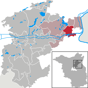
| Location of the city of Oderberg in the Barnim district | ||
  |
||


Oderberg is a town in the Barnim district in the state of Brandenburg . It belongs to the office of Britz-Chorin-Oderberg .
geography
Oderberg lies on the eastern edge of the Eberswalder glacial valley , on the edge of the Schorfheide-Chorin biosphere reserve and on the northern edge of the Oderbruch . The Alte Oder flows through the city . The Oder flows past 5 km away and forms the border with Poland. The Lower Oder Valley National Park begins a few kilometers north of Oderberg .
The city lies in the triangle of the cities Eberswalde, Bad Freienwalde and Angermünde. In the southeast it has a small share of the island of Neuenhagen .
City structure
According to the main statute, Oderberg has no districts. The city's residential areas are Alte Försterei, Breitefenn , Teufelsberg Colony , Maienpfuhl , Oderberg-Neuendorf and Steinlager.
The formerly independent community of Neuendorf was incorporated into the town of Oderberg in 1961.
history
Prehistoric settlement
Settlement of the area around Oderberg is documented as early as the Mesolithic . There are also numerous finds from the Neolithic and Bronze Age . Evidence of this era is a stone circle at the Jewish cemetery , as well as numerous finds on the windmill field . Several bronze spout axes and completely preserved vessels from the area are exhibited in the city's museum. Traces from the Iron Age , such as ceramics from settlements and burial grounds, indicate a settlement. From the middle of the 7th century settlement activities of Slavic settlers have been proven on sites . A fortified settlement was possibly built on the Albrechtsberg as early as the 9th century. From the 10th to the 13th century there was a Pomeranian-Slavic princely castle on today's Albrechtsberg. Numerous archaeological finds prove their existence. Opposite the fortress Werder there was a Niederungsburg at the same time, which presumably served to monitor the Oder river.
The Battle of Zehden between Duke Mieszko I of Poland and the Margrave Hodo I of the Lausitz region, appointed by Emperor Otto I , took place near the later settlement of Oderberg .
12th to 16th centuries
Archeology was able to determine an ancient Slavonic castle complex on the "Albrechtsberg" and a Younger Slavic castle wall under the later fortress "Bärenkasten"; the Slavic village was called Barsdyn. The Ascanian Margrave Albrecht II of Brandenburg , reports the Märkische Fürstenchronik without a year, built the first German castle on a hill; regional historical research is based on 1214. The first German settlements emerged below the castle on the eastern and southern slopes of the mountain. Oderberg was first mentioned in a document in 1231, as a Vogtei. Civitas (city) Oderberg was first mentioned in 1259. In 1231 a foundation of the Premonstratensian Order was set up in the Slavic settlement of Barsdin . The abbey was named Civitas Dei - City of God. The mother monastery of this new establishment was the Premonstratensian monastery in Brandenburg an der Havel ; it was the last founding of this order in the Mark Brandenburg. Protected by the castle and located at the transition over the Oder to the Neumark , the city developed very quickly. The city benefited on the one hand from the Via Imperii (Reichsstraße), which ran here until Margrave Waldemar was reassigned in 1316 , and on the other hand from the Oder River and the Oder crossing. Oderberg experienced a heyday in the Middle Ages.
In 1308 a Kietz near Oderberg was mentioned. These are the remains of the village Barsdyn, which is mentioned in the document from 1231. On April 5, 1317, Margrave Waldemar confirmed his privileges to the town of Oderberg for the Oderberg harbor.
In the battle of Oderberg in 1349, Ludwig the Roman suffered a defeat. The castle on the Albrechtsberg was probably completely destroyed in the process, as the Lords von Wedel and von Uchtenhagen had a new castle built on the fortress Werder from the demolition material ( fortress Oderberg , the so-called bear box ) from 1353 to 1355 . The Marienhospital, which was located in Oderberg until 1372, moved to Chorin due to the threat of the turmoil of the war . On December 13, 1415, Margrave Friedrich I of Brandenburg confirmed the settlement justice of the city , which meant that all traders had to offer their goods for sale before they were allowed to travel on. In 1430, Oderberg came into the possession of the von Pfuel family . A Saturday weekly market has been handed down from 1442; in 1532 there were two market days a week and in 1621 even four market days. A school in the city was mentioned in 1543 and 1577.
17th to 18th centuries
Until 1630 the Thirty Years War was hardly noticeable in the area, but Oderberg was occupied by its strategic location and the fortress "Bärenkasten" was besieged by Swedish troops. Gustav Adolf left Oderberg on June 16, 1631 . During the next siege in 1637, almost the entire city was reduced to rubble. In 1670 the newly built town burned down partially and completely in 1672, triggered by an oven fire. In 1727, master rope maker Matthias Tennert ran a rope factory in Angermünder Strasse. For the year 1733 there are 20 breweries in Oderberg that primarily brewed beer. In 1736 the approximately 100-strong garrison of the fortress was withdrawn and the artillery was brought to Stettin . In the severe winter of 1740, almost all of the vines in the city's vineyards froze to death . The winemaking was then stopped by decree. In 1789 it is reported that the numerous Oderberg potters mine their clay in the Grunewald near Oderberg.
Brandenburg fortress commanders
- 1636 Captain Baltasar Kunitz
- 1639 (?) Captain Friedrich August von Kötteritz
- 1665–1674 Lieutenant Colonel Wolf Friedrich von Bromsdorff
- 1677–1687 Lieutenant Colonel Hans Joachim von Hagen
- 1687–1698 Colonel Friedrich Wilhelm von der Marwitz
19th to 21st century
In 1871 there were 11 sawmills and 15 shipyards in Oderberg, and from 1874 an Oderberg newspaper. Since the opening of the railway line on January 1, 1877, Oderberg also had a rail connection and owned three stations: Oderberg (Mark), Oderberg (Bralitz) and Saaten-Neuendorf. For this purpose, the Borsig company built the railway bridge over the Alte Oder in spring 1875 . In 1895 there were starch , barrel and cement factories . In addition, fishing, which has been handed down since the Middle Ages, played a major economic role. At the beginning of the 20th century, the Oderberger See was one of the largest timber stores in Germany; sometimes more than 500,000 cubic meters of wood were stored here .
Administrative history
Oderberg belonged to the Angermünde district in the province of Brandenburg since 1817 and to the Eberswalde district in the GDR district of Frankfurt (Oder) from 1952 . The city has been in the Brandenburg district of Barnim since 1993. Oderberg was from 1992 to 2008 the seat of the Oderberg office , which was dissolved on December 31, 2008 .
Population development
|
|
|
Territory of the respective year, number of inhabitants: as of December 31 (from 1991), from 2011 based on the 2011 census
politics
City Council

The city council of Oderberg consists of 12 members and the honorary mayor with the following distribution of seats:
| Party / group of voters | Seats |
|---|---|
| Alliance for Oderberg | 7th |
| SPD | 4th |
| CDU | 1 |
(As of: local election on May 26, 2019)
The city council elected on May 25, 2014, was dissolved by the district administrator because more than half of the legal number of seats was no longer occupied due to resignations and resignation of city council members. A new election on April 10, 2016 was therefore necessary.
mayor
- 1998–2003: Brigitte Brandenburg (SPD)
- 2003–2008: Klaus Schulenburg
- 2008–2015: Roman Stähr (Alliance for Oderberg)
- since 2015: Martina Hähnel (Alliance for Oderberg)
Hähnel was elected for a further term of five years in the mayoral election on May 26, 2019 with 61.5% of the valid votes.
coat of arms
Blazon : “In silver over a green shield base a tinned, square, three-towered red castle with a black gate and open golden gate leaves. A red, gold-armored eagle hovers over the towers, each with a black window. ”The coat of arms was approved on March 16, 1993.
Sights and culture
The cultural monuments of Oderberg entered in the list of monuments of the state of Brandenburg are summarized in the list of architectural monuments in Oderberg and the list of ground monuments in Oderberg .
- Nikolaikirche, neo-Gothic brick building, built from 1853 to 1855.
- Ruins of the Oderberg Fortress (the so-called bear box )
- Inland shipping museum with open-air exhibition and Elbe paddle steamer Riesa
- War memorial on the Albrechtsberg
- Albrechtsberg Castle Wall
- Marowski-Haus am Oberkietz (oldest house in town - half-timbered building)
- Half-timbered houses on Berliner and Angermünder Strasse
- Jewish cemetery
- Neuendorf manor house, distillery and church

Nikolaikirche
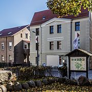
Inland shipping museum with open-air exhibition

Paddle steamer Riesa , used by the Saxon Steamship Company until 1976
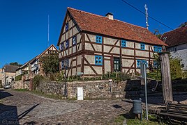
Marowski House on Oberkietz


Churches
Former Nikolaikirche
Nothing has been preserved from this church from the first half of the 13th century. According to the ground plan documented in 1852, the stone block construction was a cruciform church of considerable dimensions. The expansion of the church was about 32 meters in east-west and north-south directions. The building was entered via the north arm of the cross. On the north wall of the eastern arm of the cross was the sacristy , which was entered from inside the church. Adjacent between the eastern and southern arms of the cross there is a room that may have been a side chapel. A shift between the east and west arms of the cross is not due to a construction error, but rather typical for buildings of that time. A multi-story wooden church tower rose on the southern arm of the cross. The east gable had a brick panel as an architectural decorative element. The east choir had Romanesque arched windows, the rest of the church already showed features of the early Gothic .
.jpg)
The church was badly damaged by the siege by the Swedish troops in the Thirty Years War and by the fire in 1670. Repairs to the wooden steeple in 1754 are also reported. Sources from the 19th century report that the entire building was in serious disrepair. On October 28, 1849, Pastor Alberti held the last service. Shortly afterwards, the altar and the organ were dismantled and the church was closed because it was in disrepair. On May 22nd, 1852 it collapsed completely except for the eastern part. Attempts to rebuild the old church failed due to funding. On behalf of the Prussian King Friedrich Wilhelm IV. An expert opinion was prepared, as a result of which all reconstruction plans were finally rejected.
Nikolaikirche
The design for a new building comes from the builder Gaudtner and was supplemented by Friedrich August Stüler . It was planned to have a three-aisled basilica with a high central nave and an octagonal tower in the neo-Gothic style. The estimated construction cost was 33,000 thalers. The foundation stone was laid on June 12, 1853 in the presence of the Prussian king, who had subsidized the building with 18,000 thalers. The inauguration of the new Nikolaikirche took place on October 14, 1855 after only two years of construction. The colored glass windows used in 1999–2002 were made by the glass artist Annelie Grund .
Neuendorf village church

The church in Neuendorf is one of the oldest churches in the region in the form of a hall church made of stone blocks , it dates from the second half of the 13th century. The south portal and the neighboring window to the west, both with early Gothic pointed arches made of field stone ashlars, are still original from the construction period. The upper tower floors, with brick-framed edges and openings, were probably increased in the 14th century. The narrow lancet windows east of the portal were renewed in the early modern period with a rounded arch. The east gable has an originally preserved three-window group and is adorned with panels that end in brick arches. The external dimensions of the flat-roofed hall church are 24 meters in length and 11 meters in width. The wall thickness averages 1.10 meters. From the sacristy on the north side of the building, the foundations and stairs as well as an outlet stone with a channel are still present. In the southeast corner of the church there is a so-called checkerboard stone with a diamond pattern. In the literature the church is described several times as a fortified church , but there is no evidence for this. The interior of the village church has historically valuable furnishings: the two-tier wooden altar dates from the late Renaissance around 1615 and shows the crucifixion and resurrection of Christ on two paintings. The church pews on the south wall with ten seats were donated in 1615 by Jobst von Oppen and his wife Katharina. In 1991 excavations in the church uncovered several graves and a crypt that can be assigned to the 16th to 18th centuries.
Regular events
In addition to a May fire, an Easter festival and a Christmas market, the fishermen and boatmen festival takes place every year in June. The Spielmannszug Oderberg 1961 e. V. also organizes an annual Christmas concert.
traffic
The B 158 ( Angermünde - Berlin) crosses Oderberg from north to south . State road L 29 ( Biesenthal - Hohenfinow - Oderberg) flows into the city from the west .
Oderberg was with the Saaten-Neuendorf train station , the Oderberg stop and the Oderberg-Bralitz train station on the Angermünde – Bad Freienwalde railway line . Oderberg-Bralitz was about two kilometers south of the city. The railway line, which has not been in operation since 1995, was dismantled in 2009. The station building is privately owned.
The Oder-Havel Canal - identical in the urban area to the developed Alte Oder - flows through Oderberg from west to east.
Personalities
sons and daughters of the town
- August Colberg (1829-1868), pathologist
- Erich Haucke (1901–1942), politician ( NSDAP )
- Siegfried Schumacher (1926–2018), writer
- Hans Kulicke (1934-2016), football referee
- Eva Bosch (* 1941), painter
- Frank Nossack (* 1943), actor
Personalities associated with Oderberg
- Berthold Feistel (1834-1892), printer and newspaper publisher, lived in Oderberg
- Paul Kunisch (1862–1938), town musician in Oderberg
- Alexander Conrady (1875 – after 1909), historian, lived in Oderberg
- Max Friediger (1884–1947), rabbi in Oderberg
- August Karsten (1888–1981), politician ( SPD ), lived in Oderberg
- Heinrich Vogel (1902–1989), pastor in Oderberg
literature
- To Eberswalde, Chorin and the Werbellin-See (= values of our homeland . Volume 34). 1st edition. Akademie Verlag, Berlin 1981.
- Lieselott Enders : Historical local dictionary for Brandenburg, Part VIII, Uckermark. Weimar 1986, ISBN 3-7400-0042-2 .
- Horst Fleischer: Chronicle of Oderberg . Oderberg 2005.
- Ernst Riedel: Codex diplomaticus Brandenburgensis. Collection of documents on the history of the Mark Brandenburg and its rulers . Volume 13, G. Reimer, Berlin 1857 ( online with Google Book Search ).
- Wolf Russow, Nadine Jentzsch: Chronicle of the Mariensee Monastery 1258–1273–2007 . Chorin 2007, ISBN 3-936932-13-1 .
- Anna Plothow : Oderberg in the Mark . In: Märkische sketches . Berlin: Schall & Rentel, undated, pp. 77–87.
Web links
- Oderberg.info. private website to Oderberg
- Inland Shipping Museum Oderberg
Footnotes
- ↑ Population in the State of Brandenburg according to municipalities, offices and municipalities not subject to official registration on December 31, 2019 (XLSX file; 223 KB) (updated official population figures) ( help on this ).
- ↑ Main statutes of the city of Oderberg from February 16, 2009 PDF
- ^ Service portal of the Brandenburg State Administration - City of Oderberg
- ↑ Contribution to the statistics of the State Office for Data Processing and Statistics. Historical municipality register of the State of Brandenburg 1875 to 2005 7.15 pm District Uckermark PDF
- ↑ The Oderberg Castle was part of the statue for Albrecht II in the former Berlin Siegesallee , see picture in monument group 4 .
- ^ City of God in the travel guide of the Premonstratensian Order
- ^ Leopold von Ledebur: Adelslexikon der Prussischen Monarchy . Rauh, 1856, p. 197.
- ↑ Historical municipality register of the state of Brandenburg 1875 to 2005. District Barnim . Pp. 18-21
- ↑ Population in the state of Brandenburg from 1991 to 2015 according to independent cities, districts and municipalities , Table 7
- ^ Office for Statistics Berlin-Brandenburg (Ed.): Statistical report AI 7, A II 3, A III 3. Population development and population status in the state of Brandenburg (respective editions of the month of December)
- ^ Result of the local election on May 26, 2019
- ^ Result of the local elections on May 25, 2014
- ^ New election of the Oderberg City Council
- ^ Results of the local elections in 1998 (mayoral elections) for the district of Barnim ( Memento from March 30, 2018 in the Internet Archive ). The State Returning Officer, State of Brandenburg.
- ↑ Local elections October 26, 2003. Mayoral elections , p. 22
- ↑ Local elections in the state of Brandenburg on September 28, 2008. Mayoral elections , p. 8
- ^ Scandal after the mayor election. In: Märkische Onlinezeitung , July 10, 2015
- ↑ Brandenburg Local Election Act, Section 73 (1)
- ^ Result of the mayoral election on May 26, 2019
- ↑ Coat of arms information on the service portal of the state administration of Brandenburg
- ^ Dehio Handbook Brandenburg. 2012, p. 734.
Ahrensfelde | Althüttendorf | Bernau near Berlin | Biesenthal | Breydin | Britz | Chorin | Eberswalde | Friedrichswalde | Hohenfinow | Joachimsthal | Liepe | Lunow-Stolzenhagen | Marienwerder | Melchow | Niederfinow | Oderberg | Panketal | Parsteinsee | Rüdnitz | Schorfheide | Sydower Fliess | Wandlitz | Werneuchen | Ziethen