Niederfinow
| coat of arms | Germany map | |
|---|---|---|

|
Coordinates: 52 ° 50 ' N , 13 ° 56' E |
|
| Basic data | ||
| State : | Brandenburg | |
| County : | Barnim | |
| Office : | Britz-Chorin-Oderberg | |
| Height : | 6 m above sea level NHN | |
| Area : | 13.29 km 2 | |
| Residents: | 590 (Dec. 31, 2019) | |
| Population density : | 44 inhabitants per km 2 | |
| Postal code : | 16248 | |
| Area code : | 033362 | |
| License plate : | BAR, BER, EW | |
| Community key : | 12 0 60 172 | |
| LOCODE : | DE NIW | |
| Office administration address: | Eisenwerkstrasse 11 16230 Britz |
|
| Mayoress : | Peggy Prince | |
| Location of the community Niederfinow in the district of Barnim | ||
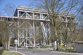
Niederfinow [ niːdɐ̯ˈfiːnoː ] is an official municipality in the Barnim district of Brandenburg . It is administered by the Britz-Chorin-Oderberg Office. The community is known nationwide for the Niederfinow ship lift .
geography
Niederfinow is part of the historic Uckermark landscape . To the north, the Schorfheide-Chorin biosphere reserve and the Plagefenn total reserve border Niederfinow. The place is located on the northern edge of the Eberswalder glacial valley and extends for about 5 km along the Hebewerkstraße.
The place lies below the Diluvial plate in the Eberswalder glacial valley , which arose in the most recent ice age, the Weichsel ice age . The Finow Canal and the Alte Finow run through the village .
The main building site is sand and gravel sand, and the groundwater level is very low. Niederfinow extends over 5 km in east-west and 1.5 km in north-south direction.
Community structure
Niederfinow has no districts or inhabited parts of the municipality. The Stecherschleuse residential area belongs to the community .
history
Early days
After the Vistula Ice Age , people immigrated to the Hohenfinow area. Bronze Age shards were found near Liebenstein (today part of Hohenfinow) . Between Hohenfinow and Amalienhof, on the edge of the glacial valley, a prehistoric burial ground is suspected. The stone boxes were destroyed in the 18th century, but individual remains of weapons were found. A sword from the Younger Bronze Age was found in the moor near Karlswerk.
Finow Castle
The place is of Slavic origin. The region was conquered by the Ascanians around 1200 . After the construction of about 10 km from the Castle Oderberg (then Low German "vein Castle") in 1213 was at the strategic point above the Finow the castle Finow founded. In 1904, during excavations at Hohenfinow Castle at a depth of 2.50 m, a Mecklenburg bull's head bracteat was found, which was minted around 1220. This year is assumed to be the year the castle was built.
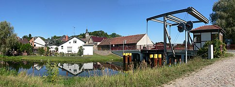
The castle had the task of protecting the ford of the Finow (today Niederfinow lift bridge). The next fords were ten kilometers to the west and ten kilometers to the east near the cities of Eberswalde and Bad Freienwalde (Oder) , which had not yet been founded . The Slavs in the north and east were to be deterred, the castle offered protection for the surrounding agricultural areas.
Name of the place
The name Finow comes from pre-Slavic times. The Middle Low German word fino (u) we probably means root . It is made up of the Indo-European pen = mud, swamp, water, moist and uei, ui = twist, bend, wind , which were combined with the West Germanic suffix -n and the Slavic -ov . Finow means freely transmitted winding river with swamps . At the time the area around Hohenfinow and Niederfinow was settled by the Slavs, the hill south of the Finow river was strategically important. The ford near Neustadt (today Eberswalde ) was less clear due to the topographical conditions; today's district town only gained importance in 1317 through a determination by Margrave Waldemar . Waldemar decreed that the trade route from Frankfurt (Oder) and Berlin to Stettin no longer had to run via Hohenfinow / Niederfinow, but via Neustadt-Eberswalde. To do this, he had a bridge built over the Ragöse . The establishment of the Finow Castle and the town of Hohenfinow as the most important settlement at the time on the 35 kilometer long river give rise to the name. About the same time as Niederfinow, a few kilometers south of Hohenfinow was built , which was named because of the customs office for land and water customs on the river via Vienouie .
Later other places were created that have the river in their name: Finow and Finowfurt .
The place has changed its name several times in history, but the original meaning has been retained.
- 1258 Vinow
- 1267 in molendino Vinaie inferioris (Niederfinow mill)
- 1288 date Vinow (given to Finow)
- 1308 Civitas Vinow (City of Finow)
- 1334 oppidum Niederfinow (small town Niederfinow)
- 1350 nedder Vinow
- 1421 Stedeken took nedder vynow
- 1482 Stedeken vino
- 1542 Little town of Niedervinow
- 1688 Neder Vinn on the vine vine
- 1718 Nieder Vinow and Niedervienow
- from 1769 Niederfinow or Nieder Fihnow .
- 1805 spots Nieder-Finow
Administrative history
Niederfinow belonged to the Angermünde district in the province of Brandenburg since 1817 and to the Eberswalde district in the GDR district of Frankfurt (Oder) from 1952 . The community has been located in the Brandenburg district of Barnim since 1993.
Population development
|
|
|
|
|
Territory of the respective year, number of inhabitants: as of December 31 (from 1991), from 2011 based on the 2011 census
politics
Community representation
The municipal council of Niederfinow consists of eight members plus the honorary mayor with the following distribution of seats:
| Party / group of voters | Seats |
|---|---|
| For our Niederfinow | 6th |
| SPD | 1 |
| Single applicant Siegfried Kunert | 1 |
(As of: local election on May 26, 2019)
mayor
- 2003–2008: Siegfried Schiefelbein
- 2008–2014: Hartmut Teichmann
- 2014: Kerstin Bergmann
- 2015–2016: Ute Peters-Pasztor
- 2017–2019: Günther Gollner
- since 2019: Peggy Fürst
In the mayoral election on May 26, 2019, Fürst was elected with 88.5% of the valid votes for a term of five years without an opposing candidate.
Attractions
The cultural monuments of the community are listed in the list of architectural monuments in Niederfinow and in the list of ground monuments in Niederfinow .
Buildings
Are under monument protection
- Boat lift
- Niederfinow lock staircase (forerunner of the ship lift)
- Power house
- Village church
Historical monuments
- Memorial stone on the Choriner Strasse / Hebewerkstrasse cemetery for the victims of fascism (1956)
- Memorial stone 750 years Niederfinow at the crossroads in the village (2008)
Economy and Infrastructure
Established businesses
Next to the ship lift operated by the Eberswalde Waterways and Shipping Office, the Stecher lock is located in Niederfinow (km 84.39 of the Finow Canal ). There are several restaurants and a hotel around the ship lift, and there is a campground in the Stecherschleuse district. In addition to farms, there are also food manufacturing companies. Some companies are also active in the service industry.
traffic
Niederfinow is located on the L 29 state road between Oderberg and Hohenfinow .
Niederfinow station is on the Eberswalde – Frankfurt (Oder) railway in the neighboring village of Hohenfinow . It is served by the regional train line RB 60 Eberswalde - Frankfurt (Oder) by the Niederbarnimer Eisenbahn .
The Barnimer bus company goes to Niederfinow with line 916 (Eberswalde – Oderberg).
The Oder-Havel Canal runs past Niederfinow . In order to overcome a difference in altitude of 36 meters, four locks were once operated here, but they soon reached their capacity limits. The Niederfinow boat lift was built to replace the locks. It was opened on March 21, 1934.
The Finow Canal also runs through Niederfinow.
Leisure and sports facilities
The Niederfinow sports field is located behind the train station in Hohenfinow. There is a gym on Choriner Straße.
Personalities
- Emil Karow (1871–1954), pastor in Niederfinow
Trivia
In 1950 an iron meteorite weighing 287 grams was found near Niederfinow . The meteorite was classified as Type IAB and registered under the official name "Nieder Finow".
literature
- Siegfried Schiefelbein: Niederfinow - a place with floating ships. Chorin Monastery, Chorin 2008, ISBN 978-3-936932-19-5
- Chorin and the surrounding area. Niederfinow boat lift. Plague. (Tourist hiking booklet 29). Tourist Verlag, Berlin / Leipzig 1978
Web links
- Niederfinow on Märkische Eiszeitstraße
- Contribution to the RBB program Landschleicher on May 2, 2010
Individual evidence
- ↑ Population in the State of Brandenburg according to municipalities, offices and municipalities not subject to official registration on December 31, 2019 (XLSX file; 223 KB) (updated official population figures) ( help on this ).
- ^ Service portal of the state administration Brandenburg. Niederfinow municipality
- ^ Gerhard Schlimpert: The place names of Barnim - Brandenburgisches Namenbuch Vol. 5, Böhlau, Weimar 1984, p. 135
- ^ Siegfried Schiefelbein: Niederfinow - a place with floating ships. 1258-1267-2008. Chorin Monastery, Chorin 2008, ISBN 978-3-936932-19-5
- ↑ Map of the Upper and Lower Barnimic Circle in 1769
- ↑ Historical municipality register of the state of Brandenburg 1875 to 2005. District Barnim . Pp. 18-21
- ↑ Population in the state of Brandenburg from 1991 to 2015 according to independent cities, districts and municipalities , Table 7
- ^ Office for Statistics Berlin-Brandenburg (Ed.): Statistical report AI 7, A II 3, A III 3. Population development and population status in the state of Brandenburg (respective editions of the month of December)
- ^ Result of the local election on May 26, 2019
- ↑ Local elections October 26, 2003. Mayoral elections , p. 22
- ↑ Dream result: 100 percent for Teichmann. In: Märkische Oderzeitung , October 23, 2008
- ^ Official Journal for the Office Britz-Chorin-Oderberg. Edition 8/2014, p. 5
- ↑ Ute Peters-Pasztor new mayor In: Märkische Oderzeitung , February 4, 2015
- ^ Official Journal for the Office Britz-Chorin-Oderberg , Edition 2/2017, p. 10
- ↑ Brandenburg Local Election Act, Section 73 (1)
- ^ Result of the mayoral election on May 26, 2019
- ↑ Nieder Finow. Meteoritical Bulletin, accessed June 7, 2020 .


