
Parsteinsee
| coat of arms | Germany map | |
|---|---|---|

|
Coordinates: 52 ° 56 ' N , 14 ° 3' E |
|
| Basic data | ||
| State : | Brandenburg | |
| County : | Barnim | |
| Office : | Britz-Chorin-Oderberg | |
| Height : | 60 m above sea level NHN | |
| Area : | 17.06 km 2 | |
| Residents: | 561 (Dec. 31, 2019) | |
| Population density : | 33 inhabitants per km 2 | |
| Postal code : | 16248 | |
| Area code : | 033365 | |
| License plate : | BAR, BER, EW | |
| Community key : | 12 0 60 185 | |
| Community structure: | 2 districts | |
| Office administration address: | Eisenwerkstrasse 11 16230 Britz |
|
| Mayor : | Michael striker | |
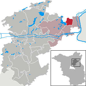
| Location of the Parsteinsee community in the Barnim district | ||
  |
||

Parsteinsee is an official municipality on the northeastern edge of the Barnim district (Brandenburg). It is administered by the Britz-Chorin-Oderberg Office.
geography
The community is located on the eastern shore of Lake Parstein, about 21 kilometers northeast of the district town of Eberswalde .
Community structure
Parsteinsee consists of the districts Lüdersdorf and Parstein .
history
Lüdersdorf and Parstein belonged to the Angermünde district in the province of Brandenburg since 1817 and to the Eberswalde district in the GDR district of Frankfurt (Oder) from 1952 . Both places have been in the Brandenburg district of Barnim since 1993.
The Parsteinsee community emerged on March 1, 2002 from the voluntary amalgamation of the previously independent communities of Lüdersdorf and Parstein.
Population development
| year | Ludersdorf | Parstein | year | Parsteinsee | |
|---|---|---|---|---|---|
| 1875 | 522 | 528 | 2002 | 596 | |
| 1910 | 468 | 477 | 2005 | 574 | |
| 1939 | 508 | 382 | 2010 | 557 | |
| 1946 | 630 | 549 | 2015 | 556 | |
| 1950 | 689 | 574 | 2016 | 541 | |
| 1971 | 530 | 383 | 2017 | 542 | |
| 1990 | 373 | 291 | 2018 | 538 | |
| 1995 | 341 | 284 | 2019 | 561 | |
| 2000 | 316 | 300 | |||
| 2001 | 302 | 295 |
Territory of the respective year, number of inhabitants: as of December 31 (from 1991), from 2011 based on the 2011 census
politics
Community representation
The Parsteinsee community council consists of eight community representatives and the honorary mayor. The local election on May 26, 2019 resulted in the following distribution of seats:
| Voter group | Seats |
|---|---|
| Interest group for the Parstein volunteer fire brigade | 4th |
| Parsteinsee voter initiative | 2 |
| General group of voters Parsteinsee | 1 |
| Alternative voter community Parsteinsee | 1 |
mayor
- 2003–2019: Hans-Jürgen Otto
- since 2019: Michael Stürmer
Stürmer was elected in the mayoral election on May 26, 2019 with 64.2% of the valid votes for a term of five years.
badges and flags
The Parsteinsee community has a coat of arms and a flag. The right to use the coat of arms was granted to her in a certificate from the Minister of the Interior of Brandenburg on June 22, 2004.
- Description of coat of arms
- "Diagonally divided by gold over blue, at the top two black ears with awning, the left one outside with a kinked stalk, at the bottom two silver fish , offset one above the other, swimming to the left "
- Flag description
- "Three-striped blue-white-blue in a ratio of 1: 2: 1 with the municipal coat of arms in the central strip, when hung on a cross piece."
Attractions
Worth seeing in the district of Lüdersdorf are two listed Vorlaubenhäuser (Niederdt. Loewinghus), including one that the German Foundation for Monument Protection has contributed to the restoration . All architectural monuments are recorded in the list of architectural monuments in Parsteinsee and in the list of archaeological monuments in Parsteinsee .
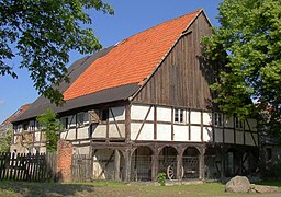
Porch house

Porch house

Vorlaubenhaus (GDR postage stamp 1981)

Parstein war memorial
Lüdersdorf village church


_1981,_MiNr_2628.jpg)


traffic
Parsteinsee is located on the B 158 between Angermünde and Bad Freienwalde (Oder) .
Lüdersdorf station (Kr Eberswalde) was on the Angermünde – Bad Freienwalde railway line , on which passenger traffic was discontinued in 1995.
Personalities
- Johann Bödiker (1641–1695), educator, preacher in Parstein
Web links
- Lüdersdorf in the RBB program Landschleicher on January 24, 2010
- Parstein in the RBB program Landschleicher on February 20, 2005
Individual evidence
- ↑ Population in the State of Brandenburg according to municipalities, offices and municipalities not subject to official registration on December 31, 2019 (XLSX file; 223 KB) (updated official population figures) ( help on this ).
- ^ Service portal of the state administration Brandenburg. Parsteinsee parish
- ^ Formation of a new parish in Parsteinsee. Announcement of the Ministry of the Interior of February 5, 2002. Official Journal for Brandenburg - Joint Ministerial Gazette for the State of Brandenburg, Volume 13, Number 9, of February 27, 2002, p. 227 PDF .
- ↑ Historical municipality register of the state of Brandenburg 1875 to 2005. District Barnim . Pp. 18-21
- ↑ Population in the state of Brandenburg from 1991 to 2015 according to independent cities, districts and municipalities , Table 7
- ^ Office for Statistics Berlin-Brandenburg (Ed.): Statistical report AI 7, A II 3, A III 3. Population development and population status in the state of Brandenburg (respective editions of the month of December)
- ^ Result of the local election on May 26, 2019
- ↑ Local elections October 26, 2003. Mayoral elections , p. 22
- ↑ Brandenburg Local Election Act, Section 73 (1)
- ^ Result of the mayoral election on May 26, 2019
- ↑ a b BLHA : Parsteinsee municipality coat of arms
- ↑ a b § 2 paragraph 1 and 2 of the main statute of the Parsteinsee municipality of March 9, 2009
Ahrensfelde | Althüttendorf | Bernau near Berlin | Biesenthal | Breydin | Britz | Chorin | Eberswalde | Friedrichswalde | Hohenfinow | Joachimsthal | Liepe | Lunow-Stolzenhagen | Marienwerder | Melchow | Niederfinow | Oderberg | Panketal | Parsteinsee | Rüdnitz | Schorfheide | Sydower Fliess | Wandlitz | Werneuchen | Ziethen