
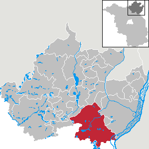
Angermünde
| coat of arms | Germany map | |
|---|---|---|

|
Coordinates: 53 ° 1 ′ N , 14 ° 0 ′ E |
|
| Basic data | ||
| State : | Brandenburg | |
| County : | Uckermark | |
| Height : | 51 m above sea level NHN | |
| Area : | 324.19 km 2 | |
| Residents: | 13,757 (Dec. 31, 2019) | |
| Population density : | 42 inhabitants per km 2 | |
| Postal code : | 16278 | |
| Primaries : | 03331, 033334 (fracture Hagen, Neuhaus, Steinhofel, Schmiedeberg, Wilmersdorf) , 033,335 (Frauenhagen, Mürow) , 033,336 (Greiffenberg, Güntersberg) , 033,337 (Altkünkendorf, Wolletz) , 033,338 (Gellmersdorf, Stolpe) , 033,365 (Bölkendorf) , 038,961 ( Pintuck brow) | |
| License plate : | UM, ANG, PZ, SDT, TP | |
| Community key : | 12 0 73 008 | |
| LOCODE : | DE AMU | |
| City structure: | 23 districts | |
City administration address : |
Markt 24 16278 Angermünde |
|
| Website : | ||
| Mayor : | Frederik Bewer (independent) | |
| Location of the city of Angermünde in the Uckermark district | ||
  |
||


Angermünde ( ) is a small town in the Uckermark district in the state of Brandenburg in Germany . It has been a state-recognized resort since 2010 .
geography
With around 324 km 2, Angermünde is one of the largest municipalities in Germany (15th place). This corresponds roughly to the size of Bremen or Dresden .
Geographical location
The city is located about 80 km northeast of Berlin , in the Uckermark between Schorfheide-Chorin and Oder . It forms the southeast of the district of Uckermark , borders in the south on the district of Barnim and in the east, in the district of Stolpe, almost on the Republic of Poland .
City structure
In addition to the core city , Angermünde consists of 23 districts . The vast majority of these are integrated communities of the former Angermünde-Land office . Greiffenberg is a specialty . It was one of the smallest cities in Germany and is now a “city within a city”.

There are also 40 living spaces with z. T. own history: Altenhof, Augustenfelde , expansion, expansion Mürower Straße, expansion Pinnower Weg, expansion Welsower Weg, Bauernsee, Blumberger Mühle , Breitenteicher Mühle, Friedrichsfelde, Gehegemühle, Glambecker Mühle, Greiffenberg settlement, Grumsin, Henriettenhof, Klein Frauenhagen, Leistenhof, Leopoldsthal, Linde, Lindenhof, Louisenhof, Luisenthal , Mürow-Oberdorf, Neu-Günterberg, Neuhaus , Neuhof, Peetzig, Rosinthal, Schäferei, Sonnenhof, Sternfelde , Stolper Mühle, Thekenberg, Waldfried, Waldfrieden, Wilhelmsfelde , Wilhelmshof, Ziethenmühle and Zollende .
The residential areas Erichshagen , Heinrichshagen , Kreuz , Krummensee and Siebershof have gone .
Neighboring communities
Angermünde borders on the following communities (clockwise, starting from the north): Oberuckersee , Gramzow , Zichow , Mark Landin , Pinnow , Schöneberg , Lunow-Stolzenhagen , Parsteinsee , Chorin , Ziethen , Althüttendorf , Joachimsthal , Friedrichswalde , Temmen-Ringenwalde and Flieth-Stegelitz .
Geology and geomorphology
The eastern tip reaches the Lower Oder Valley , otherwise the city belongs to the Uckermark basin and hill country. The surface was shaped by the Vistula glacial period during the Pomeranian stage . Its main edge of the ice swings like a backbone from northwest to southeast through the landscape. The terminal moraine chain of hills is the most distinctive in the eastern North German lowlands . Located in on her Grumsiner Forest at Altkünkendorf the block mountain . At 137.4 m, it marks the highest elevation in the Uckermark and in the district of the same name . The Telegraphenberg (136.4 m) located a little to the east follows as number two. The contiguous inland ice between Angermünde and Prenzlau dissolved . Therefore, the three following seasons, including the Angermünder, left much weaker, only incompletely traceable terminal moraines. However, the strength was sufficient for the Ucker basin to be clearly defined.
The Fennoscan Ice Sheet brought numerous massive boulders around Angermünde, most of them in the southwest, in the Grumsiner Forest. The largest measure around 18, 16 and 13 m 3 . All three are made of gneiss - granite , the latter having a proper name with moss stone . The granite memorial stone on the village square of Dobberzin has a volume of around 4 m 3 . The city is crossed by the Märkische Eiszeitstraße .
Waters

The core city lacks a river . Through the incorporation, Angermünde moved in the east to the Oder , more precisely the Hohensaaten-Friedrichsthaler Wasserstraße and in the north to its tributary Welse . The urban area is enriched by numerous Uckermark lakes .
|
|
|
climate
| Angermünde (period 1961–1990) | ||||||||||||||||||||||||||||||||||||||||||||||||
|---|---|---|---|---|---|---|---|---|---|---|---|---|---|---|---|---|---|---|---|---|---|---|---|---|---|---|---|---|---|---|---|---|---|---|---|---|---|---|---|---|---|---|---|---|---|---|---|---|
| Climate diagram | ||||||||||||||||||||||||||||||||||||||||||||||||
| ||||||||||||||||||||||||||||||||||||||||||||||||
|
Monthly average temperatures and precipitation for Angermünde (period 1961–1990)
Source: wetterkontor.de
|
|||||||||||||||||||||||||||||||||||||||||||||||||||||||||||||||||||||||||||||||||||||||||||||||||||||||||||||||||||||||||||||||||||||||||||||||||||||||||||||||||||||
natural reserve
Parts of the Schorfheide-Chorin Biosphere Reserve are located in the south and west of the urban area. This includes u. a. the nature reserve Grumsiner Forst / Redernswalde . The terminal moraines and domed ground moraines contain numerous, diverse lakes , moors and small bodies of water. Just west of Altkünkendorf, it is worth visiting the Große Wiese nature observation point. One of the two embedded core zones belongs to Angermünde. The Grumsiner Forest is the largest of the total reserves with around 657 hectares. Above all, old red beech forests expand on sand and boulder clay , and there are several species of orchids, globe flowers and swamp porst . Various endangered species such as beavers , ospreys , otters , gray cranes , black storks , white-tailed eagles and eagle owls live here . The meanders of the catfish near Görlsdorf and the Sernitz near Greiffenberg are considered natural streams . The administrative seat of the UNESCO natural heritage moved from Eberswalde to Angermünde in 2001 .
The south of the Lower Oder Valley National Park extends beyond Stolpe .
history
Origin of the place name
Anno 1263 appeared Henricus de Angermunde ( CDB , main section A, Volume XIII, certificate CCXXVII, p 482), the citizens of Szczecin be fathered a certificate . The Märkische Fürstenchronik spoke of Novin-Tangermunde in 1267 . The spellings Neuen Angermünde in 1286, Nova Angermunde 1292 and Nien Angermunde 1305 still reveal the origin of the personal name . Before that, a cleric was called Johannes dictus de angermunde in 1273 (CDB, main part A, volume XI, document XI, pp. 8–9). Office holder Walterus prefectus in Angermünde noted in 1277 (CDB, main part A, Volume XIII, Document XXV, pp. 220–221). Then came 1286, 1287, 1296, 1305, etc. each variant Angermunde .
The place name was transferred from the Altmark , Tangermünde located at the confluence of the Tangier into the Elbe . The German e river name stands for a fresh, strong running water '. The addition New was used at times to differentiate. The connection was soon forgotten. The t was seen as to 'zu', i.e. 'T (o) Angermünde' and the common word Anger was added to it. The initial letter was therefore omitted.
middle Ages

Between 1210 and 1230, a castle was built at a crossroads of trade routes to protect the new German settlers. The first stone church ( Marienkirche ) was also built in 1210 . Between 1245 and 1250 the first Franciscan monastery church was built from field stones, which was renovated from bricks in the 15th century. Nine years after Margrave Johann I was granted city rights in 1254, Angermünde was first mentioned in a document in 1293. In 1313 there was an allodial acquisition of all lakes in the Stolpe region , which previously belonged to Griffike von Greiffenberg and Zabel von Badelo. In the Battle of Angermünde in 1420, the Brandenburgers defeated the Pomeranians.
Modern times
In 1817 Angermünde became the district town of the Angermünde district in the Prussian province of Brandenburg . In 1842 the city got a railway connection through the Berlin-Szczecin Railway , followed by the founding of the Görlsdorf stud farm in 1883. On September 13, 1891, a war memorial for those who died in the Wars of Unification was ceremoniously unveiled on the west side of the market square, based on a design by Albert Manthe . The two statues on the pedestal were the Emperors Wilhelm I and Friedrich III. dar; the group of the two emperors was repeated in 1893 for the war memorials in Solingen-Ohligs and Weißwasser .
In the night of the pogrom in 1938, the synagogue on Klosterstrasse was burned down. The Jewish cemetery on Puschkinallee was also destroyed. Towards the end of the Second World War , three German soldiers were hanged as Wehrmacht deserters on February 22, 1945 . Since 1965 a memorial stone has commemorated them in the Friedenspark. A short time later, on April 27, 1945, the master baker Miers and the jeweler Nölte ran towards the advancing Soviet troops on the road to Schwedt and, after brief negotiations, surrendered the town without a fight. Angermünde was spared from war damage. However, the war memorial on the market square had to be demolished in the same year on the orders of the Soviet occupying power by German helpers who were forced to do so.
From 1952 to 1990 Angermünde was the district town of the Angermünde district in the GDR district of Frankfurt (Oder) , then in the state of Brandenburg . Since the district reform in Brandenburg in 1993, the city has been part of the Uckermark district .
Incorporations
| Former parish | date | annotation |
|---|---|---|
| Altkünkendorf | December 31, 2000 | |
| Biesenbrow | October 26, 2003 | |
| Bölkendorf | October 26, 2003 | |
| Bruchhagen | October 26, 2003 | |
| Crussow | October 26, 2003 | |
| Dobberzin | 1st January 1974 | |
| Frauenhagen | October 26, 2003 | |
| Gellmersdorf | October 26, 2003 | |
| Görlsdorf | October 26, 2003 | |
| Greiffenberg | October 26, 2003 | |
| Günterberg | October 26, 2003 | |
| Heart leap | October 26, 2003 | |
| Kerkow | October 26, 2003 | |
| Mürow | October 26, 2003 | |
| Neuhaus | January 1, 1957 | Incorporation to Steinhöfel |
| Neukünkendorf | October 26, 2003 | |
| Obergreiffenberg | January 1, 1928 | Incorporation to Greiffenberg |
| Schmargendorf | October 26, 2003 | |
| Schmiedeberg | October 26, 2003 | |
| Steinhöfel | October 26, 2003 | |
| Stolpe / Or | October 26, 2003 | |
| Welsow | October 26, 2003 | |
| Wilmersdorf | October 26, 2003 | |
| Wolletz | October 26, 2003 | |
| Zuchenberg | 1841 |
Dobberzin was incorporated at the beginning of 1974, Altkünkendorf at the end of 2000. In October 2003, the municipalities of the Angermünde-Land office were added, with the exception of Poland .
Population development
|
|
|
|
|
Territory of the respective year, number of inhabitants: as of December 31 (from 1991), from 2011 based on the 2011 census
The strong population growth in 2003 is due to the incorporation of 20 previously independent municipalities.
politics
City Council

The city council of Angermünde consists of 22 members and the full-time mayor with voting rights . The local elections on May 26, 2019 led to the following result:
| List / party | Share of votes | Seats |
| Social Democratic Party of Germany (SPD) | 26.0% | 6th |
| Christian Democratic Union of Germany (CDU) | 15.9% | 3 |
| The left | 15.3% | 3 |
| Rural community of Angermünde | 14.5% | 3 |
| Alliance 90 / The Greens (Greens) | 7.4% | 2 |
| Free community of voters Angermünder citizens | 7.1% | 2 |
| Voting group Angermünde center | 5.5% | 1 |
| Free Democratic Party (FDP) | 3.3% | 1 |
| Single applicant Michelle Diebetz | 2.6% | 1 |
mayor
- 1989–1998: Wolf-Hugo Just
- 1998–2016: Wolfgang Krakow (SPD)
- since 2016: Frederik Bewer (independent)
Frederik Bewer was elected in the mayoral election on May 8, 2016 with 95.3% of the valid votes for a term of eight years. His opponent Olaf Theiss (SPD) did not run for the runoff election.
coat of arms

Blazon : “In silver over four blue waves, a red castle with three tinned towers; From the larger central tower grows a hunter dressed in green, blowing a golden horn , the open gate is covered with a golden stag's head; on the right side tower a blue spangenhelm with three green peacock feathers, on the left side tower a red eagle . "
The city coat of arms changed several times over the years. Various seals served as a template . A document from the Chorin monastery from 1316 shows a good representation. The combination of the Pomeranian helmet with the Brandenburg eagle refers to the changing nationality. A legend is entwined around the two figures in the middle .
“… Angermünde used to be surrounded by forests rich in game, and the lords of the castle often went hunting with their helpers . Once they had chased a handsome stag from morning on, but to no avail. Only in the evening succeeded him on the banks of Pomerania Lake encircle. In desperation, the animal jumped into the water and swam towards the city, where the water was right up to the city wall . There the stag ran ashore and through the open gate . In the market place he was at the end of his strength and allowed himself to be seized. That ended the hunt. A hunter rushed to the gate and blew from the tower, the Halali . As a reminder, the swimming deer was included in the city arms. "
In its current form, the coat of arms dates from 1976. Approval took place on January 3, 1995.
Town twinning
- Espelkamp in North Rhine-Westphalia
- Lügde in North Rhine-Westphalia
- Strzelce Krajeńskie in Poland
- Żurrieq in Malta
Sights and culture
Buildings
In the list of monuments in Angermünde in the list of monuments of the country are Brandenburg construction registered monuments .
Old town


The historical appearance of the old town was largely preserved. Angermünde is a member of the “Cities with Historic Town Centers” working group in the state of Brandenburg . The rehabilitation program launched in 1990 expired in 2007. With a few exceptions, all buildings in the city center have been renovated. The Franciscan monastery and the St. Mary's Church dominate among them .
- Stadtpfarrkirche Sankt Marien , Gothic hall church with three aisles , partially painted ( Protestant-unified )
- Town hall , two-storey plastered building with a baroque facade, was built in 1699 on the foundations of a Gothic predecessor. The originally five- axis building was expanded to include two more axes in 1711 and 1712. An extensive renovation was carried out between 1992 and 1999. In front of the building there is a fountain by the artist Christian Uhlig . In the course of the redesign of the market in 1994, he won the Angermünde market fountain competition .
- Council scales , built in 1752 to weigh large goods such as balls of wool using the council scales. It has been the seat of the tourist information office since 2000.
- Franciscan monastery church Peter and Paul
- Powder tower with city wall
- Remains of the former city castle (built at the beginning of the 13th century) in the northwest corner of the city
- Holy Spirit Chapel (15th century, three-bay hall church with star vaults )
- Martinskirche , built in 1854 ( Old Lutheran , today SELK )
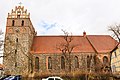
City parish church St. Marien

Market square with town hall

Detail of the market fountain

Franciscan monastery church Peter and Paul

Powder tower

Holy Spirit Chapel

Martinskirche
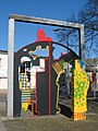
"Closed open" by Christian Uhlig


.JPG)

Suburbs
- Old malt house
Incorporated surrounding area
- Greiffenberg Castle
- Stolpe Castle
- Blumberger Mill
- Some more or less restored manor houses , e.g. B .:
- Altkünkendorf
- Kerkow
- Mürow
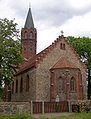
- Several village churches :
- Bölkendorf
- Dobberzin
- Frauenhagen
- Greiffenberg
- Grillmersdorf
- Mürow
- Welsow
- Telecommunication tower Angermünde (near Altkünkendorf)

Altkünkendorf manor house
Stüler Church in Altkünkendorf

Bölkendorf village church

Görlsdorf Castle around 1860, Alexander Duncker collection

Ruins of the castle Greiffenberg in Güntersberg

War memorial in Herzsprung

Vorlaubenhaus in Schmiedeberg

Modern porch in Schmiedeberg

"Grützpott" of Stolpe Castle in Stolpe


Historical monuments
- To commemorate the no longer preserved Seetor , the city has set up a hewn boulder in the shape of the gate and an information board on Seestrasse / corner of Wasserstrasse. Similar boulders are reminiscent of the Berliner Tor , the Schwedter Tor and the Prenzlauer Tor , which were also demolished.
- Since 1950, behind the graves of three hanged conscientious objectors in the cemetery on Schwedter Strasse, a memorial has been commemorating the resistance and victims of fascism
- Monument from 1964 on the former Jewish cemetery on a hill east of Bundesstrasse 198 north of the Günterberg district, where the Jewish community of Greiffenberg established its cemetery in 1809
Museums

- Ehm wilt and local history museum
- Franciscan monastery , parts of the museum's collection
- Heimatstube and Schmiedemuseum Schmargendorf
- NABU information center Blumberger Mühle
Cultural institutions
- Angermünde district cultural center , after 1945 to 1991
- Angermünde City Archives, founded in 1972
- Angermünde City Library, founded in 1946 as a city and district library
Recreation
The Angermünde Zoo, founded in 1963, is the only zoo in the Uckermark . On an area of 7 hectares, it houses around 250 animals of 45 species from all continents. As a specialty, there are all six camel species : dromedary , trample , guanaco , llama , alpaca and vicuna . The zoo participates in the European Endangered Species Program (EEP) with keeping vicuñas and taffeta monkeys .
Regular events

On the initiative of the Altkünkendorfer artist Joachim Karbe , sculptors from all over Europe have been meeting every two years for the Angermünder Hard Rock Symposium since 1991 . As material for their work, the artists use the uckermärk een boulders . The last glacial period about 10,000 years ago left the large granite stones behind . The works of art are exhibited for two years at the Mündesee as well as in various places in the old town and on the Mündesee promenade.
- Uckermärkische Blasmusiktage - folk festival every year at the beginning of June
- Energie Open Air - pop and rock festival in the nearby Wolletzsee lido in August (approx. 5000 visitors annually)
- Angermünder Gänsemarkt - annually on the second weekend in Advent
- Children's Christmas market - (annually on the third weekend in Advent)
Economy and Infrastructure
Companies

In the area between Biesenbrow and Greiffenberg there were several inland salt stations . The salt works operated there were probably destroyed in the Thirty Years War (1618–1648).
Although the city is still home to some traditional industries, it is increasingly turning to tourism . The high unemployment forced many Angermünders to emigrate to economically stronger areas of Germany.
traffic
Road traffic
In the Middle Ages three trade routes crossed south of the Mündesees : 1) Prenzlau - Gramzow - Oderberg , 2) Templin - Schwedt and 3) Berlin - Eberswalde - Welse ford near Stendell - Stettin . The relocation of the latter from Niederfinow to Eberswalde in 1317 also strengthened Angermünde. From the beginning of the 19th century, the old Heerstraße or Poststraße Berlin –Stettin ran again via Schwedt, a branch connected to Stolpe . Chaussee Berlin – Stettin opened in 1826, and Angermünde – Prenzlau in 1830.
The federal highways B 2 to Schwedt, B 158 to Bad Freienwalde and B 198 from Joachimsthal to Prenzlau lead through Angermünde . The state road L 28 leads to Passow . The Joachimsthal and Pfingstberg motorway junctions on the A 11 Berlin – Stettin are around 16 and 19 kilometers from the city center, respectively.
The city of Angermünde is connected to three important long -distance cycle paths with the Uckermärkischer Radrundweg , the Berlin – Usedom cycle path and the Oder-Neisse cycle path . Most recently, the gap in the Berlin – Usedom cycle path between the Blumberger ponds and the districts of Görlsdorf and Peetzig was expanded at the end of 2007.
Rail transport

The station Angermünde is a major transportation hub in northeastern Brandenburg . Rail routes go from Berlin via the Angermünde-Stralsund Railway to Stralsund , via the Berlin-Szczecin Railway to Stettin and via the Angermünde-Schwedt Railway to Schwedt (Oder) . Since the route to Stettin is not electrified , travelers have to switch to diesel trains here.
Angermünde train station is served by the following regional express and regional train lines :
- RE 3 Stralsund / Schwedt (Oder) –Berlin– Falkenberg (Elster) / Lutherstadt Wittenberg
- RE 66 Berlin-Lichtenberg - Szczecin Główny
- RB 61 Angermünde – Schwedt (Oder)
- RB 62 Angermünde– Prenzlau
- RB 66 Angermünde – Szczecin Główny
RB 62 trains also stop at Wilmersdorf station (b Angermünde) .
The 30 km long Angermünde – Bad Freienwalde railway was shut down on November 30, 1997. Considerations of using them for tourism with trolleys - such as Fürstenberg – Templin - were rejected.
Shipping
That since the High Middle Ages of Angermunde of exported grain was on or after Stettin ver embarks . Stolpe served as the closest port . 1350 was the former city in Schwedt the Customs promised freedom.
education

schools
- Gustav Bruhn Elementary School
- Pushkin Elementary School
- Free school Angermünde: pre-school, elementary school and high school
- Ehm-Welk Comprehensive School
- Einstein-Gymnasium Angermünde
- General special school
Vocational schools
- BSA Private Vocational School Angermünde
- ABW Angermünder Bildungswerk
- Ergotherapy school "Regine Hildebrandt" Angermünde
media
A local editorial team for the Märkische Oderzeitung , the only daily newspaper in the region, works on site. Every year, as the journalistic highlight of the end of the cultural year, an Angermünde calendar published by the city appears . The local TV station Uckermark TV based in Prenzlau (until January 2011 TV Angermünde Lokal ) also broadcasts local information.
Sports
- Angermünder FC (plays in the national soccer class North in the 2019/20 season)
- TSG Angermünde (volleyball, boxing, ju-jutsu , judo, chess, weightlifting)
- Handball club 1952 Angermünde
- Angermünde volleyball club
- Railway Sports Club 49 (running group, table tennis)
- Paintball court Angermünde
- other clubs in the districts
Personalities
Honorary citizen
- Ehm Welk (1884–1966), writer
sons and daughters of the town

- Tobias Magirus (1586–1652), professor of logic and physics
- Paul Erdmann Isert (1756–1789), botanist
- Jean-Pierre Guillaume Catteau-Calleville (1759–1819), geographer in the French service
- Friedrich Heinrich von der Hagen (1780–1856), Germanist
- August Julius Streichenberg (1814–1878), sculptor
- Frederick Baumann (1826–1921), architect in Chicago
- Frieda Amerlan (1841-1924), writer
- Albert Manthe (1847–1929), sculptor
- Max Jenne (1848–1921), pharmacist, entrepreneur and politician
- Otto Albrecht (1855–1939), Protestant pastor and theologian
- Rudolf von Valentini (1855–1925), politician, born in Crussow
- Hermann Dietrich (1856–1930), politician ( DNVP ), born in Schmargendorf
- Georg Knaack (1857–1905), classical philologist and high school teacher
- Wilhelm Schleyer (1859–1936), architect
- Hans Follmann (1863–1935), ministerial official
- Johannes Pundt (1864–1943), racing cyclist
- Emil Sieg (1866–1951), Indologist and Tocharologist
- Bruno Marwitz (1870–1939), legal scholar
- Louis Müldner von Mülnheim (1876–1945), court official to Crown Prince Wilhelm of Prussia
- Gustav Bruhn (1889–1944), politician (KPD), resistance fighter against National Socialism
- Hans-Erich Voss (1897–1969), Vice Admiral in World War II
- Paul Harpe (1902–1983), politician (NSDAP)
- Günter Reimann (1904–2005), economist and journalist
- Hans Henschke (1908–1987), SS leader
- Wolfgang Heinze (1911–1945), resistance fighter against National Socialism
- Heinrich Borgmann (1912–1945), Adolf Hitler's adjutant
- Hans Joachim Leidel (1915–1962), doctor and writer
- Karl-Heinz Krause (1924–2019), sculptor
- Dagobert Krause (1926–2009), trade unionist
- Karin Jeltsch (1935–2017), politician (CDU)
- Bärbel Wachholz (1938–1984), pop singer
- Manfred Losch (1938–2009), hammer thrower
- Sabine Schröder (* 1942), politician (SPD)
- Wolfgang Merzenich (1942–2012), computer scientist
- Hartmut Losch (1943–1997), discus thrower
- Marion Lau (* 1947), politician (SPD)
- Gerlinde Stobrawa (* 1949), politician (Die Linke), born in Altkünkendorf
- Angelika Noack (* 1952), rower
- Maik Heydeck (* 1965), boxer
- Thomas Barz (* 1966), spinal surgeon
- Julia Jäger (* 1970), actress
Personalities associated with the city
- Eugen von Röder (1808–1888), District Administrator in Angermünde
- Alexander von Buch (1814–1885), District Administrator in Angermünde
- Wolf-Hugo Just (1940–2013), 1989 first freely elected mayor
- Christian Uhlig (* 1944), sculptor, lives in Angermünde
- Diana Golze (* 1975), politician (Die Linke), grew up in Angermünde
literature
- in alphabetical order by authors / editors
- Wolfgang Blaschke , Ingo Nagel: Angermünde and the surrounding area. Sutton Verlag, Erfurt 2006, ISBN 978-3-86680-021-2 .
- Wolfgang Blaschke (author), Dirk Schumann (archeology, building history): Angermünde. Franciscans . In: Heinz-Dieter Heimann , Klaus Neitmann , Winfried Schich and others (eds.): Brandenburgisches Klosterbuch. Handbook of the monasteries, pens and commander by the mid-16th century. Volume I (= Klaus Neitmann on behalf of the Brandenburg Historical Commission and in connection with the Brandenburg State Main Archive (ed.): Brandenburg Historical Studies . Volume 14). 2 volumes, Be.Bra Wissenschaft Verlag, Berlin 2007, ISBN 978-3-937233-26-0 , pp. 96-102.
- Richard Dietrich: Angermünde (Kr. Angermünde) . In: Gerd Heinrich (Ed.): Berlin and Brandenburg. With Neumark and Grenzmark Posen-West Prussia (= Handbook of Historic Places . Volume 10; Kröner's pocket edition . Volume 311). 3rd, revised and supplemented edition, Alfred Kröner Verlag, Stuttgart 1995, ISBN 3-520-31103-8 , pp. 6-7.
- Lieselott Enders (adaptation): Historical local dictionary for Brandenburg. Uckermark. With an overview map in the appendix (= Friedrich Beck (Hrsg.): Historisches Ortslexikon für Brandenburg . Part VIII; Publications of the Potsdam State Archives . Volume 21). Hermann Böhlaus successor, Weimar 1986, ISBN 3-7400-0042-2 (gives a reprint from 2012).
- Lieselott Enders: Angermünde. District of Uckermark (36 km south of Prenzlau) . In: Lieselott Enders, Evamaria Engel , Gerd Heinrich, Winfried Schich (eds.): City Book Brandenburg and Berlin (= Peter Johanek , Franz-Joseph Post, Klaus Meyer-Schwickerath in the Institute for Comparative Urban History at the University of Münster (ed.): Deutsches City book, handbook of urban history, volume 2). Verlag W. Kohlhammer, Stuttgart / Berlin / Cologne 2000, ISBN 3-17-015388-9 , pp. 4–10.
- Lieselott Enders: The Uckermark. History of a Kurmark landscape from the 12th to the 18th century (= Klaus Neitmann (Hrsg.): Publications of the Brandenburg State Main Archives . Volume 28). 2nd, unchanged edition, Berliner Wissenschafts-Verlag, Berlin 2008, ISBN 978-3-8305-1490-9 .
- Frauke Gränitz, Luise Grundmann on behalf of the Leibniz Institute for Regional Geography Leipzig and Saxon Academy of Sciences in Leipzig (ed.): Around Eberswalde, Chorin and the Werbellinsee. A geographical inventory in the area of Eberswalde, Hohenfinow and Joachimsthal (= landscapes in Germany. Values of the German homeland . Volume 64). Böhlau Verlag, Cologne / Weimar / Vienna 2002, ISBN 3-412-02401-5 .
- Kerstin Kirsch: Slavs and Germans in the Uckermark. Comparative studies on the development of settlements from the 11th to the 14th century (= Spiritual Science Center for the History and Culture of East Central Europe eV at the University of Leipzig (ed.): Research on the history and culture of eastern Central Europe . Volume 21). Franz Steiner Verlag, Stuttgart 2004, ISBN 3-515-08604-8 .
- State Office for Mining, Geology and Raw Materials Brandenburg (Ed.): Geological overview map 1: 100,000. District of Uckermark (= geological overview map 1: 100,000. Map of the formations on the surface with representation of selected geotopes and geological objects . Map 4). Land surveying and basic geographic information Brandenburg , Potsdam 2005, ISBN 978-3-7490-4606-5 .
- Ilona Rohowski: District Uckermark Part 1: City of Angermünde and Amt Oder Welse as well as the places Criewen and Zützen (= monument topography Federal Republic of Germany . Monuments in Brandenburg . Volume 18.1). Wernersche Verlagsgesellschaft, Worms 2016. ISBN 978-3-88462-367-1 .
- Publishing bookstore Ehm Welk: Angermünde. Flair and magic of a city and its landscape. Ehm Welk publishing house, Angermünde 2008, ISBN 978-3-9811703-1-3 .
- Verlagbuchhandlung Ehm Welk: DVD film classics: The Heiden von Kummerow and their funny pranks. Ehm Welk publishing house, Angermünde 2007, ISBN 978-3-9811703-0-6 .
Web links
- Angermünde really, of course
- Ehm-Welk-Literature Museum in Angermünde
- Görlsdorf in the RBB broadcast Landschleicher on August 21, 2005
- Frauenhagen in the RBB program Landschleicher on February 27, 2005
- Energy open air
Individual evidence
- ↑ Population in the State of Brandenburg according to municipalities, offices and municipalities not subject to official registration on December 31, 2019 (XLSX file; 223 KB) (updated official population figures) ( help on this ).
- ^ Website of the city of Angermünde, chronicle .
- ↑ Press release from the Brandenburg Ministry for Economic Affairs and Energy from September 9, 2016 .
- ^ A b Service portal of the state administration of the state of Brandenburg: City of Angermünde .
- ↑ Voluntary community associations 1995–2003 ( Memento of the original from May 17, 2005 in the Internet Archive ) Info: The archive link has been inserted automatically and has not yet been checked. Please check the original and archive link according to the instructions and then remove this notice.
- ↑ Gerd W. Lutze (author), Lars Albrecht, Joachim Kiesel, Martin Trippmacher (landscape visualization): Natural spaces and landscapes in Brandenburg and Berlin. Structure, genesis and use . Be.Bra Wissenschaft Verlag, Berlin 2014, ISBN 978-3-95410-030-9 , Uckermark, Eberswalder Urstromtal and Unteres Odertal. Breakdown. [Introduction], p. 125 (see also map p. 126).
- ↑ a b c Gerd W. Lutze (author), Lars Albrecht, Joachim Kiesel, Martin Trippmacher (landscape visualization): Natural spaces and landscapes in Brandenburg and Berlin. Structure, genesis and use . Be.Bra Wissenschaft Verlag, Berlin 2014, ISBN 978-3-95410-030-9 , Uckermark, Eberswalder Urstromtal and Unteres Odertal. Breakdown. Uckermärkisches Becken- und Hügelland, pp. 129–134.
- ↑ a b Gerd W. Lutze (author), Lars Albrecht, Joachim Kiesel, Martin Trippmacher (landscape visualization): Natural spaces and landscapes in Brandenburg and Berlin. Structure, genesis and use . Be.Bra Wissenschaft Verlag, Berlin 2014, ISBN 978-3-95410-030-9 , Uckermark, Eberswalder Urstromtal and Unteres Odertal. History of origins and geology, pp. 121–123.
- ↑ A. Sonntag: Supplement Geological Overview Map 1: 100,000. Uckermark district . Land surveying and geographic base information Brandenburg, Potsdam 2005, ISBN 978-3-7490-4606-5 , 2. The district of Uckermark. 2.2 Geotopes and objects with a geological reference in the Uckermark district. Table 4: Outcrops and glacial morphological elements (selection), p. 22.
- ↑ A. Sonntag: Supplement Geological Overview Map 1: 100,000. Uckermark district . Land surveying and geographic base information Brandenburg, Potsdam 2005, ISBN 978-3-7490-4606-5 , 2. The district of Uckermark. 2.2 Geotopes and objects with a geological reference in the Uckermark district. Table 1: Overview, location and brief description of erratic boulders (selection), pp. 17–18.
- ^ Lieselott Enders: Angermünde. District of Uckermark (36 km south of Prenzlau) . In: City Book of Brandenburg and Berlin . Verlag W. Kohlhammer, Stuttgart 2000, ISBN 3-17-015388-9 , 2 The location of the city in the landscape. 2 a Natural location, p. 4.
- ↑ a b c Eberhard Henne: To Eberswalde, Chorin and the Werbellinsee . Böhlau Verlag, Cologne 2002, ISBN 3-412-02401-5 , regional overview. Natural space and land use. "Schorfheide-Chorn" biosphere reserve, pp. 34–40.
- ^ A b Rolf Schmidt: To Eberswalde, Chorin and the Werbellinsee . Böhlau Verlag, Cologne 2002, ISBN 3-412-02401-5 , appendix. D. Selected nature reserves in the study area, pp. 355–356.
- ↑ a b compass maps (ed.): Berlin and surroundings. Map 2 . Scale 1: 50,000. In: Berlin and the surrounding area. 4 cards in a set . Compass maps, Rum / Innsbruck 2011, ISBN 978-3-85026-119-7 .
- ↑ A. Sonntag: Supplement Geological Overview Map 1: 100,000. Uckermark district . Land surveying and geographic base information Brandenburg, Potsdam 2005, ISBN 978-3-7490-4606-5 , 2. The district of Uckermark. 2.2 Geotopes and objects with a geological reference in the Uckermark district. Table 3: Hydrological features, p. 20.
- ↑ a b c Lieselott Enders: Angermünde . In: City Book of Brandenburg and Berlin . Verlag W. Kohlhammer, Stuttgart 2000, ISBN 3-17-015388-9 , 1 The name of the city, p. 4.
- ↑ a b c Lieselott Enders: The Uckermark . 2nd edition, Berliner Wissenschafts-Verlag, Berlin 2008, ISBN 978-3-8305-1490-9 , 1st chapter. Become the historical landscape and first bloom. II. The development of the state in the Uckermark. 4. The high medieval urban system. Angermünde, p. 73.
- ^ Adolph Friedrich Riedel : Novus Codex diplomaticus Brandenburgensis. 1. main part. 13th volume . In: Codex diplomaticus Brandenburgensis . Collection of documents, chronicles and other sources for the history of the Mark Brandenburg and its rulers . 41 volumes, G. Reimer, Berlin 1857, 4th division. The Uckermark. VI. Mixed Uckermark documents. 227. The Walkenried monastery sells four mills near Dametzow to the monastery in Stettin, which it has owned by Duke Barnim of Pomerania and subsequently by Margraves Johann and Otto, on July 18, 1263, p. 482.
- ↑ a b c Ernst Eichler , Hans Walther : City name book of the GDR . 1st edition, Bibliographisches Institut, Leipzig 1986, ISBN 3-323-00007-2 , The city names of the GDR from A – Z. Angermünde, p. 40.
- ^ Adolph Friedrich Riedel : Riedel's Codex diplomaticus Brandenburgensis. 1. main part. 11th volume . In: Codex diplomaticus Brandenburgensis . Collection of documents, chronicles and other sources for the history of the Mark Brandenburg and its rulers . 41 volumes, G. Reimer, Berlin 1857, XXVII. City and monastery of Spandow. 11. Bishop Heinrich von Brandenburg unites eight Hufen Landes in Staken to the monastery Spandow, which Count Günzel von Schwerin carried from the bishop and that of Döbberitz from the Count to Lehn, but the latter have given the virgins of Spandow with the condition that all churches have two To provide miles in a circle with wine and wafers, March 26, 1273, pp. 8–9.
- ^ Adolph Friedrich Riedel : Novus Codex diplomaticus Brandenburgensis. 1. main part. 13th volume . In: Codex diplomaticus Brandenburgensis . Collection of documents, chronicles and other sources for the history of the Mark Brandenburg and its rulers . 41 volumes, G. Reimer, Berlin 1857, 4th division. The Uckermark. V. Chorin Monastery. 25. The Margraves Johann, Otto and Conrad donate the village of Briest to the Chorin Monastery, on June 27, 1277, pp. 220–221.
- ↑ Reinhard E. Fischer : The place names of the states of Brandenburg and Berlin. Age - origin - meaning . Be.Bra Wissenschaft Verlag, Berlin 2005, ISBN 978-3-937233-30-7 , name book. Angermünde, pp. 18-19.
- ^ Heinrich Gottfried Philipp Gengler : Regesta and documents on the constitutional and legal history of German cities in the Middle Ages , Erlangen 1863, pp. 46–47 .
- ↑ Frauke Gränitz, Luise Grundmann (ed.): To Eberswalde, Chorin and the Werbellinsee . Böhlau Verlag, Cologne 2002, ISBN 3-412-02401-5 , Zuchenberg, to Angermünde since 1841, pp. 133-134.
- ^ Federal Statistical Office (Ed.): Municipalities 1994 and their changes since January 1, 1948 in the new federal states . Metzler-Poeschel publishing house, Stuttgart 1995, ISBN 3-8246-0321-7 .
- ^ StBA: Changes in the municipalities in Germany, see 2000 .
- ^ StBA: Changes in the municipalities in Germany, see 2003 .
- ↑ Historical municipality register of the state of Brandenburg 1875 to 2005. District Uckermark . Pp. 14-17.
- ↑ Population in the state of Brandenburg from 1991 to 2017 according to independent cities, districts and municipalities , Table 7.
- ^ Office for Statistics Berlin-Brandenburg (Ed.): Statistical Report AI 7, A II 3, A III 3. Population development and population status in the state of Brandenburg (respective editions of the month of December).
- ^ Result of the local election on May 26, 2019 .
- ↑ Wolf-Hugo Just passed away - pioneering work of a new administration. In: Märkische Oderzeitung , August 15, 2013.
- ↑ It was a great time. In: Märkische Oderzeitung , June 28, 2016.
- ↑ Brandenburg Local Election Act, Section 74 .
- ^ Result of the mayoral election on May 8, 2016
- ^ Angermünder runoff election with only one candidate . In: Märkische Onlinezeitung , May 6, 2016.
- ^ A b Albert Burkhardt (selection and processing), Ralf-Jürgen Lehmann (illustration): The treasure of Chorin. Legends and fairy tales from the Mark Brandenburg . Stapp Verlag, Berlin 1991, ISBN 3-87776-570-X , The city arms of Angermünde, pp. 29-30.
- ↑ Coat of arms information on the service portal of the state administration of Brandenburg .
- ↑ a b Heinz Göschel (Ed.): Lexicon cities and coats of arms of the German Democratic Republic . 3rd edition, Bibliographisches Institut, Leipzig 1985, DNB 860113086 , Angermünde, pp. 18-19.
- ^ Lieselott Enders: Angermünde . In: City Book of Brandenburg and Berlin . Verlag W. Kohlhammer, Stuttgart 2000, ISBN 3-17-015388-9 , 12 The landmarks. 12 b coat of arms, p. 8.
- ↑ Entry in the state monument list .
- ^ Wolfgang Blaschke: Angermünde. Franciscans . In: Brandenburg monastery book. Volume I . Be.Bra Wissenschaft Verlag, Berlin 2007, ISBN 978-3-937233-26-0 , 2 historical outline. 2.2 Re-use, later fate (church, building, complex), p. 97.
- ↑ a b Lieselott Enders: Angermünde . In: City Book of Brandenburg and Berlin . Verlag W. Kohlhammer, Stuttgart 2000, ISBN 3-17-015388-9 , 17 Education. 17 b Cultural institutions, p. 9.
- ^ Lieselott Enders: Angermünde . In: City Book of Brandenburg and Berlin . Verlag W. Kohlhammer, Stuttgart 2000, ISBN 3-17-015388-9 , 17 Education. 17 c Scientific institutions, p. 9.
- ↑ A. Sonntag: Supplement Geological Overview Map 1: 100,000. Uckermark district . Land surveying and geographic base information Brandenburg, Potsdam 2005, ISBN 978-3-7490-4606-5 , 2. The district of Uckermark. 2.2 Geotopes and objects with geological reference in the Uckermark district, pp. 16–22.
- ^ Lieselott Enders: Angermünde . In: City Book of Brandenburg and Berlin . Verlag W. Kohlhammer, Stuttgart 2000, ISBN 3-17-015388-9 , 2 The location of the city in the landscape. 2 b Traffic situation, p. 4.
- ↑ a b Lieselott Enders: Angermünde . In: City Book of Brandenburg and Berlin . Verlag W. Kohlhammer, Stuttgart 2000, ISBN 3-17-015388-9 , 8 The economy. 8 a Economic development, pp. 6–7.
- ↑ a b Lieselott Enders: Angermünde . In: City Book of Brandenburg and Berlin . Verlag W. Kohlhammer, Stuttgart 2000, ISBN 3-17-015388-9 , 6 The urban population and the social structure. 6 e Important personalities, p. 6.
- ↑ Wolf-Hugo Just passed away - pioneering work of a new administration . In: Märkische Onlinezeitung , August 15, 2013.
Angermünde | Berkholz-Meyenburg | Boitzenburger Land | Brüssow | Carmzow-Wallmow | Casekow | Flieth-Stegelitz | Gartz (Oder) | Gerswalde | Göritz | Gramzow | Grünow | Hohenselchow-Groß Pinnow | Lychen | Mark Landin | Mescherin | Milmersdorf | Mittenwalde | Northwestuckermark | Oberuckersee | Passow | Pinnow | Prenzlau | Randow Valley | Schenkenberg | Schöneberg | Schönfeld | Schwedt / Oder | Tantow | Temmen-Ringenwalde | Templin | Uckerfelde | Upland | Zichow