
Blumberger Mill
|
Blumberger Mill
Community Angermünde
Coordinates: 53 ° 2 ′ 15 ″ N , 13 ° 56 ′ 40 ″ E
|
|
|---|---|
| Postal code : | 16278 |
| Area code : | 03331 |

Blumberger Mühle is a residential area in the Görlsdorf district of the city of Angermünde in the Uckermark district (Brandenburg). The mill probably already existed in 1261 when it was transferred by the von Greiffenberg to the Mariensee monastery, the forerunner of the Chorin monastery . About 1.3 km to the east is the NABU information center Blumberger Mühle , which was built in 1997. The Blumberger Mühle residential area and the NABU information center are on the edge of the Fischteiche Blumberger Mühle nature reserve, which is part of the Schorfheide-Chorin biosphere reserve.
location
The Blumberger Mühle residential area is located two kilometers south-southwest of the center of Görlsdorf, three kilometers northeast of Wolletz, 3.2 km west of Kerkow and about 4.6 kilometers northwest of the city center of Angermünde. The Erichshagen residential area, which has now disappeared, was about 500 meters to the west . The living space is 44 m above sea level. NHN . It can be reached directly from Görlsdorf via a connecting path through the fish ponds.
The NABU information center Blumberger Mühle is located about 3.5 km northwest of the city center of Angermünde and about 1.3 km east of the Blumberger Mühle (location:) .
![]()
History of the Blumberger mill and ponds
In 1261 the von Greiffenberg left two mills to the Mariensee Monastery (from 1273 Chorin Monastery ), one in the village of Görlsdorf and a neighboring mill in the upper part of the same river Welse . The identity of this second mill with the Blumberger mill is not entirely certain, but very likely. In a document from 1267, Margrave Johann II confirmed the possessions of the Mariensee Monastery, including a. the two mills located on the Welse near Görlsdorf were.
In 1375, the Chorin monastery in the Stolp country, which now belongs to Pomerania, owned five mills on the Welse, but four of them had already fallen into disrepair at that time, one mill was a free mill.
In 1556 and 1578 the Blumberger mill was called the Heiliggeistmühle. It belonged to the equipment of the Angermünder Heilig-Geist-Spital in the middle / end of the 16th century. At that time it was counted as part of the village of Kerkow.
In 1611 the Heilig-Geist-Mühle was partly owned by Greiffenberg zu Bruchhagen. Other shares were probably owned by the other von Greiffenberg estates Flemsdorf, Frauenhagen, Altkünkendorf, Schmiedeberg, Stolpe, Wolletz and Zützen, who appear as owners of shares in the Blumberger Mühle after they became independent. In 1707 the mill was sold on a long lease to Müller Blumberg. The mill then had two gears. The mill was named after him. In 1734 the miller had four millers and a maid. The small settlement had 15 residents. There is evidence that it was operated as a grinding and cutting mill from 1745 to the end of the 19th century. In 1774, four residents lived in the settlement in addition to the miller's family. There were four fireplaces , three of which were in an apartment building. The settlement now had 21 residents. In 1790 the population is given as 33 people. Friedrich Wilhelm Bratring characterizes the Blumberger Mühle as follows: Water grinding and cutting mill on the Catfish, between Wolletz and Görlsdorf, along with four graves. 30 people lived in two fireplaces . Bratring succinctly notes the owners: has different owners. In 1855 the grain mill had two grinding aisles, a groats aisle and a barley aisle, the cutting mill had a saw. In 1858 the previously independent establishment was integrated into the Görlsdorf estate. In 1860 the settlement consisted of two residential buildings and eight farm buildings; it had 20 inhabitants. In 1871 the Blumberger Mühle had 27 residents who lived in two houses. The establishment belonged to the Görlsdorf estate.
In 1896/97 a large pond was created for the breeding of carp. The mill building was converted into a fish hatchery. The sawmill was canceled. In the 1920s the plant was the main supplier of tench and carp to Berlin . Görlsdorf was an estate district until 1928. It was not until this year that the rural community of Görlsdorf was formed through the dissolution of the manor district. However, larger parts of the Görlsdorfer Forest were incorporated into the new communities of Glambeck and Neuhaus. For this purpose, parts of the dissolved Peetzig manor district were incorporated into the new municipality of Görlsdorf. In 1931 and 1957, Blumberger Mühle was a residential area in the municipality of Görlsdorf.
In 1945 the fish farm was expropriated and made public property. In the GDR , the fish ponds belonged to the VEB inland fishing and were used for intensive fish fattening. In the years 1967-69, the Blumberger ponds were further expanded, consisting of 21 ponds on an area of 140 hectares, which supplied the fishing operations of the surrounding lakes and the pond farms at Biesenbrow and Stolpe with nesting fish . When the new ponds were excavated, a Bronze Age burial ground was found , to the west of the catfish a Bronze Age settlement as evidence of the prehistoric settlement of this area. During the time of the GDR state hunt, the area around the Blumberger Mühle was in the hunting area used by Erich Mielke and was not open to the public until 1989. In 1990 the Blumberger ponds were declared a nature reserve.
In 1993 Görlsdorf merged with 21 other communities to form the Angermünde-Land office . on October 26, 2003 Görlsdorf was incorporated into the city of Angermünde and has been a district ever since. Blumberger Mühle has the status of a residential place.
The Schorfheide-Chorin Biosphere Reserve
The Schorfheide-Chorin Biosphere comprises large parts of the cultivated land between the Upper Havel , the Lower Oder and the Barnim and was recognized by UNESCO as a biosphere reserve in December 1990 . In accordance with the biosphere concept, efforts in this approximately 129,000 hectare landscape are aimed at creating and maintaining a harmonious unity of nature, agriculture, forestry and trade. A large part of the biosphere, which is included in the global research program “ Man and the Biosphere (MAB) ”, consists of landscape protection areas , the remainder are nature protection areas including total reserves . Extensive and ecological agriculture receives special support in the landscape protection areas, possibilities of nature-friendly economic activity are being tested. One of the funded usage concepts is the establishment of "gentle" tourism.

The NABU information center Blumberger Mühle
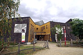
The NABU Information Center Blumberger Mühle, northwest of Angermünde in the Schorfheide-Chorin Biosphere Reserve , is the “largest and probably most unusual information center of NABU ”. With its exhibitions, a natural adventure landscape and the adjoining Blumberger Teiche nature reserve , the Blumberger Mühle offers the best conditions to “show in a model how people can live and work without destroying nature and thus the basis of life”.
The NABU-Zentrum Blumberger Mühle near Angermünde was opened as a nature information and adventure center in 1997 after a two-year construction period. The main concern is to inform visitors about the Uckermark landscape, shaped by the Ice Age , with its rich flora and fauna. At the same time, the Blumberger Mühle is the main information center of the Schorfheide-Chorin Biosphere Reserve. The German Federal Environment Foundation , the State of Brandenburg , the European Union and the Tengelmann Group have so far made a significant contribution to the establishment and maintenance of the information center .
The NABU center Blumberger Mühle
The NABU Information Center Blumberger Mühle in the change of the seasons

The courtyard of the information center


The building

The information center building, designed by the architect Bernd Kühn, is modeled on a hollow tree stump. The aim of the design was, according to the architect, “to derive the shape of the building from the forms of nature and to seize the chance of assimilating the building with the surrounding landscape.” This idea led to a free form of floor plan design that “everyone Area its own individuality ”and create a“ living sequence of rooms ”,“ which derive their analogies and similarities from the uniformity of the overall composition, from the unity in diversity, the design principle of nature. ”The hollow tree stump is not a ruin of a tree, but as a stage of existence in the “eternal cycle of birth - life - death, of arising and passing away”.
During the construction, special emphasis was placed on the use of environmentally friendly building materials (masonry made of sand-lime brick , wooden posts and clay walls , wooden windows, thermal insulation made of recycled paper , etc.). Ecological aspects also played a decisive role in the technical equipment of the information center. In addition to a low-emission gas heating system, both solar and thermal energy are used for its energy supply. Excess heat from the solar collectors is fed into 15 geothermal probes, each 32 meters deep. The subsurface is regenerated with solar heat so that the brine / water heat pump installed in the building has more geothermal energy available for heating. The green roof of the building not only compensates for part of the surface sealing caused by the building , but also makes an important contribution to thermal insulation and also offers various plants and animals a special habitat.
The exhibition
Soil and water are the central themes of the permanent, 250 square meter exhibition in the information center, the design of which placed great emphasis on interaction. So the visitor can experiment in different places, he can get on a bicycle and on a fictional bike tour explore the surroundings of the Blumberger Mühle formed by the Ice Age and its history, he can get into a boat to row across a lake and learn interesting things to learn about life in and around water. An “idyllic spot” gives the impression of sitting in the middle of the water bird reserve of the Blumberg ponds, the “swaying moor” shows the diversity of functions and the beauty of intact moors that take up around 10 percent of the area in the biosphere reserve. The forest is reflected in the permanent exhibition of the information center in the form of the “speaking tree”. Guided hikes, theme days, nature workshops or holiday programs for children complement the information offered by the Blumberger Mühle.
The restaurant and café "Zum Grünen Wunder" takes care of the physical well-being of the visitors. When the weather is nice, guests can enjoy the gastronomic service under awnings outdoors.
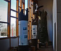
NABU Information Center -The talking tree-

NABU Information Center Blumberger Mühle

NABU Information Center -Moor Corpse-


The natural adventure landscape
Based on the idea of "making the characteristic habitats of the large protected area and the influence of humans tangible", the open-air area around the information center was structured as versatile as possible. A natural adventure landscape of around 13 hectares was created, which was deliberately designed without signposted "educational trails" and furnished with educational objects. The NSG Blumberger Teiche and a play area were integrated into this adventure landscape, which enables children to find an adventurous access to nature via modeled animal structures (beaver castle, anthill) and animal sculptures, via reeds, water and a footbridge.
During a tour of the Blumberger Mühle outdoor area, the visitor initially comes to an area in the immediate vicinity of the building that is characterized by intensive use. Here you will find a herb garden, a clay oven and a fish smokehouse, a maze and the “Biberburg” garden restaurant. As the distance from the main building increases, the intensity of human use of the landscape decreases.
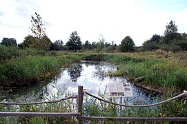
With fat meadow , wet meadow and dry grass , three habitats are shown which differ significantly due to different soils, degrees of moisture and nutrient content in their vegetation and are inhabited by different animal species. The heart of the adventure landscape is a moor created by the renaturation of an old peat layer , which is supplemented by various other bodies of water that were created in 1996 and differ in their nutrient content and flow behavior. They are fed by the Wolfswinkelgraben, which carries treated wastewater from the Angermünder sewage treatment plant . This is fed to a further biological clarification in a reed bed before it flows into the following biotopes . In addition, the bodies of water in the open-air area are fed by groundwater . A swaying wooden plank path offers the opportunity to cross the moor, where visitors can spot tree frogs , red-bellied toads and green toads in the shallow water .
Another area of the nature adventure world that is worth seeing is the approximately 2000 square meter outdoor enclosure for European pond turtles , which depicts a typical habitat for these animals. Trees and reeds on the shore characterize the enclosure, a large sand dune gives the animals the opportunity to lay their eggs in spring. The first turtles were released in 2002, and in spring 2007 visitors discovered the first hatched juveniles on the site. "Some of the young turtles were raised in the nearby rearing station of the State Environment Agency and then released into the wild to build up new populations ," the other animals remained in the outdoor enclosure.
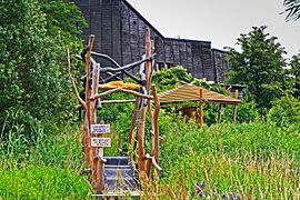
As with the construction of the information building, ecological aspects were also taken into account to a large extent in the creation of the adventure landscape. The access road to the Blumberger Mühle was "built in the form of an Altuckermärkischen field stone paving road", everywhere on the site Benjes hedges serve to delimit different rooms. At the same time, they offer birds, small mammals and amphibians a varied habitat. Benches, bridges and an observation tower, which offers the opportunity to observe the bird life on the neighboring Blumberg fish ponds, were built from local woods stained with natural oils. The catering for the catering takes place in an earth cellar next to the main building , which offers a temperature of 5 to 7 ° C throughout the year. The oven in the outdoor area was built in the traditional way with clay.
Habitat for the European pond turtle

Blumberger Mill
-Emys orbicularis-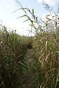
Moor area in the open air area
Blumberger Mill
-Suspension Bridge-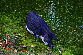
Blumberger Mühle -Mangalica Pig-

Blumberger Mill
-East Prussian Skudde-


Accessibility of the NABU information center Blumberger Mühle
From Angermünde train station, signposted cycling and hiking trails (route about 6 kilometers) lead to the information center, in the summer season from the beginning of April to the end of October the "BiberBus" (line 496) of the Uckermärkische Verkehrsgesellschaft (UVG) has also been running during the day since 2012 the Blumberger Mühle starts directly. This bus line also serves other stops around the Wolletzsee lake, which is about 1.5 kilometers southwest of the Blumberger Mühle, and thus enables access to various areas of the biosphere reserve, including the Grumsiner Forest, which has been a World Heritage Site since June 2011 . The “BiberBus” replaced the “BiberBahn”, which was in use from June 2001 to the end of the 2011 season, and which carried around 49,500 passengers between Angermünde and the Blumberger Mühle in the ten years of its existence. With its superstructures, which were modeled on a felled tree trunk, the bus and trailer operated as the “BiberBahn” was one of the tourist attractions in the region.
The wider area
The NABU information center Blumberger Mühle is closely connected to the landscape of the Uckermark and its history. Much that distinguishes this region in northeast Brandenburg is the subject of the information offered by the institution. At the same time, the Blumberger Mühle would like to inspire you to discover “this idiosyncratic region with its lakes, forests and meadows”. In addition to the Schorfheide-Chorin Biosphere Reserve and the Grumsiner Forest World Heritage Site embedded in it, there are two other large protected areas in the immediate vicinity: the Lower Oder Valley National Park and the Uckermärkische Seen Nature Park .
The villages and towns in the vicinity of the mill, which have often retained their centuries-old peculiarities, are also worth discovering personally. The towns of Angermünde, Prenzlau and Templin with their historical buildings are well worth seeing , but also the only industrial town in the Uckermark Schwedt on the Oder. A connecting element of this and other sights is the Märkische Eiszeitstraße , which leads with a length of 340 kilometers through the travel regions Barnim and Uckermark.
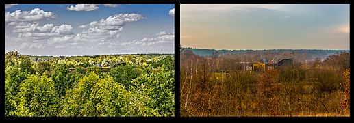
The NSG Fischteiche Blumberger Mühle
In 1993, after lengthy negotiations, the Brandenburg Nature Conservation Union (NABU) succeeded in acquiring the total area of the Blumberger Mühle, which encompasses 218 hectares, including the 140 hectares of fish ponds that have been extensively managed again since 1991, from the trust agency. For “ecological, social and political reasons”, the nature conservation association would like to maintain the management of the ponds declared as water bird sanctuaries in the long term, although it is not easy to reconcile land use and nature conservation. However, it is precisely the special form of land use that gives the nature reserve a large variety of native water birds. In addition, the ponds are important for migrating and resting water birds. A total of around 200 bird species were found in the NSG. Coots , gray and great egrets , black-headed gulls , common terns , goosander , sea eagles and ospreys as well as various Limikolen can be observed regularly . You can also observe many mammals that are rarely found elsewhere, such as beavers and otters, as well as various amphibians. This spectrum of rare and protected animal species is supplemented by a remarkable variety of plants. Over 400 vascular plant species were found in the pond area. This includes the sea can found in some ponds .
The pond is managed by Klaus-Peter Gensch, who took over the fishing business from his father. In addition to the Blumberger ponds, there are two other pond groups in Biesenbrow (owned by BUND ) and in Stolpe (located in the Lower Oder Valley National Park , owned by the Uckermark district ). There is also a lake fishery in Himmelpfort . In the Blumberger pond system, the fishing operation primarily pulls in carp and sturgeon , with the rearing of nesting fish as far as possible, as the losses from cormorants and gray herons were sometimes 100 percent. Instead, with the approval of NABU, the fishing company imports from the Czech Republic 500 to 800 grams of large pack fish, which are already too heavy for the cormorants and whose further rearing still enables a certain economic success.

View over the Blumberger ponds

Blumberger fish ponds
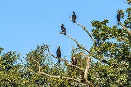
Cormorants at the Blumberg fish ponds

Gray geese at the Blumberg fish ponds

Gray geese at the Blumberg fish ponds


literature
- Lieselott Enders : Historical local dictionary for Brandenburg. Part VIII: Uckermark. Hermann Böhlaus successor, Weimar 1986, p. 530/31.
- Naturschutzbund Deutschland (NABU) e. V. (Ed.): Blumberger Mühle. A brochure accompanying the NABU Information Center Blumberger Mühle. Angermünde 1997.
- Brandenburg Volume 1 The East. Schorfheide, Barnimer Land. PRO LINE CONCEPT Beate Schubert, Berlin 1994, ISBN 3-929220-10-5 .
- Werner Ebert, Hans Domnik: Along the Märkische Eiszeitstraße. A journey through the Barnimer Land and the Uckermark. Society for Research and Promotion of the Märkische Eiszeitstraße e. V. (Ed.), 2. completely revised. and exp. Edition, Eberswalde 1997.
- Maria Klebert: Medieval monasteries in the area of the Märkische Eiszeitstraße. Discoveries along the Märkische Eiszeitstraße, issue 13, Eberswalde 2009, ISSN 0340-3718
Individual evidence
- ^ A b Hannelore Kurth-Gilsenbach : Schorfheide and Choriner Land. Neumann Verlag, Radebeul 1993, ISBN 3-7402-0128-2 , p. 57.
- ^ Friedrich Wilhelm August Bratring: Statistical-topographical description of the entire Mark Brandenburg. Second volume. Containing the Mittelmark and Ukermark. VIII, 583 pp., Berlin, Maurer, 1805 Online at Google Books , p. 528.
- ↑ Richard Boeckh: Local statistics of the government district Potsdam with the city of Berlin. 276 pp., Verlag von Dietrich Reimer, Berlin, 1861 Online at Google Books , pp. 38/37.
- ^ The municipalities and manor districts of the Prussian State and their population. According to the original materials of the general census of December 1, 1871. II. Province of Brandenburg. Verlag der Königliche Statistischen Bureaus (Dr. Engel), Berlin 1873. Online at Google Books , p. 11/12, footnote under No. 99 Görlsdorf.
- ↑ Representation of the catfish catchment area, accessed December 2012 ( Memento of the original from March 5, 2016 in the Internet Archive ) Info: The archive link was inserted automatically and has not yet been checked. Please check the original and archive link according to the instructions and then remove this notice. (PDF; 1.4 MB)
- ^ Service portal of the state administration of the state of Brandenburg: City of Angermünde
- ↑ a b c d e f g h Naturschutzbund Deutschland (NABU) e. V. (Ed.): Blumberger Mühle. An accompanying brochure. Angermünde 1997
- ↑ a b Blumberger Mühle, accessed September 2012
- ↑ waermepumpe-regional.de/angermuende, accessed June 2019
- ↑ Commissioning of the BiberBus ( Memento from September 14, 2012 in the Internet Archive )
- ↑ To the Blumberger Mühle pond fishery as of June 2010, accessed August 2012 ( Memento of the original from January 12, 2012 in the Internet Archive ) Info: The archive link was inserted automatically and has not yet been checked. Please check the original and archive link according to the instructions and then remove this notice.
Web links
- Blumberger Mühle, accessed September 2012
- Brief presentation of the Blumberger Mühle (video), accessed September 2012
- Visitor Centers of the National Natural Landscapes of Brandenburg, accessed February 2016
- Blumberger Mühle pond fishery, accessed September 2012
- Tourist offers around the Blumberger Mühle, accessed September 2012
Altkünkendorf | Biesenbrow | Bruchhagen | Bölkendorf | Crussow | Dobberzin | Frauenhagen | Gellmersdorf | Görlsdorf | Greiffenberg | Günterberg | Heart jump | Kerkow | Mürow | Neukünkendorf | Schmargendorf | Schmiedeberg | Steinhöfel | Stumble | Welsow | Wilmersdorf | Wolletz | Zuchenberg
Further places
Altenhof |
Augustenfelde |
Expansion |
Expansion of Mürower Strasse |
Expansion of Pinnower Weg |
Expansion of Welsower Weg |
Bauernsee |
Blumberger Mill |
Breitenteicher Mühle |
Friedrichsfelde |
Enclosure mill |
Glambeck Mill |
Greiffenberg settlement |
Grumsin |
Henriettenhof |
Klein Frauenhagen |
Groin |
Leopoldsthal |
Linden tree |
Lindenhof |
Luisenhof |
Luisenthal |
Mürow-Oberdorf |
Neu-Günterberg |
Neuhaus |
Neuhof |
Peetzig |
Rosinthal |
Sheep farm |
Sonnenhof |
Sternfelde |
Stumbling Mill |
Thekenberg |
Waldfried |
Forest Peace |
Wilhelmsfelde |
Wilhelmshof |
Ziethenmühle |
Customs end

Arnimswalde | Beesenberg | Blumberg Forest | Boitzenburger Tiergarten and electricity | Bollwinwiesen / Großer Gollinsee | Breitenteichische Mill | Brüsenwalde | Buchheide | Charlottenhöhe | Damerow Forest | Damerower Wald, Schlepkower Wald and Jagenbruch | Dolgenseen-Ragollinsee | Eiskellerberge-Os near Malchow | Terminal moraine landscape near Ringenwalde | Owl Mountains | Felchowsee area | Fish ponds Blumberger Mühle | Geesower Hill | Big Hell near Luckow-Petershagen | Great Briesensee | Great Plötzsee | Grumsiner Forst / Redernswalde | Back ponds at Biesenbrow | Hutung Sähle | Jungfernheide | Kiecker | Rattle Mountains | Kleine Schorfheide | Knehden Moor | Köhntoptal | Krinert lakes | Küstrinchen | Labüskewiesen | Landiner Haussee | Mellensee near Lychen | Melzower Forest | Mewenbruch | Müllerberge | Lower Oder Valley National Park | Netzowsee-Metzelthiner Feldmark | Piepergrund | Platkowsee | Poratzer moraine landscape | Randow slopes near Schmölln | Reiersdorf | Salveytal | Black Tangier | Alluvial pool | Silver Mountains Gartz | Stromtal | Suckower Haussee | Suckowseen | Deep lake | Boitzenburg Zoo | Broken peat near Poland | Dry grass Geesow | Dry lawn Groß Pinnow | Dry lawn Jamikow | Angle | Zerweliner paddock | Zichower Wald - vineyard