Barnim
The Barnim is a plateau formed during the Ice Age and at the same time a historical landscape in central and northeastern Brandenburg and in northeast Berlin .
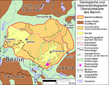
As part of the Brandenburg plates and glacial valleys formed during the Vistula Ice Age, the Barnim consists of ground moraines , a terminal moraine and sand areas between the Berlin glacial valley in the south and the Eberswalde glacial valley in the north.
Today the districts of Oberhavel , Barnim , Märkisch-Oderland and Oder-Spree have a share in Barnim . In Berlin's urban area, the districts of Reinickendorf , Pankow , Lichtenberg and Marzahn-Hellersdorf are largely located on the Barnim.
Delimitation and subdivision
Demarcation
The boundary of the natural area Barnim can be defined quite precisely, as it is almost exclusively clearly defined. The southern border forms the Berlin glacial valley, through which the Spree flows here . The Teltow plateau joins further south . The border between the Barnim and the small country Glien further to the west is covered by an glacial valley running from north to south . This in turn is traversed by a glacial channel , which today houses the Havel lakes . The Eberswalde glacial valley borders the Barnim in the north and northeast . However, the north-eastern part, today's Oderbruch , has a significantly different landscape character than the western sections of the Eberswalder Valley. The Buckow -Rinne or Löcknitz - Stobber -Rinne, which in addition to these two rivers is shaped by the Roten Luch , the Stobberbach and chains of lakes, forms the border to the neighboring country of Lebus , with which the Barnim is scenically related.
Breakdown
The Barnim is traditionally subdivided into the lower or lower barnim and the high or upper barnim. The Niederbarnim occupies the southwestern part of the plateau, the Oberbarnim the northeastern part. The boundary between the two units is not precisely defined; usually a line from Strausberg over the Gamengrund to Eberswalde is set as a border.
The subdivision into Niederen and Hohen Barnim is justified because the majority of the plateau of the Niederen Barnim is below 80 m above sea level. NN lies. Only in the outskirts of the Oberbarnim does the plateau rise up to 90 m. Large parts of the Barnim plateau in the Berlin urban area are even less than 60 m. The Hohe Barnim, on the other hand, has extensive heights of over 100 m above sea level. NN. The Semmelberg near Wölsickendorf is 157.6 m above sea level. NN the highest elevation of the Barnims. Less than 5 km away, the Untere Oderbruch is just a few meters above sea level.
cities and communes
Until the strong growth of Berlin in the late 19th century, the Barnim was only sparsely populated. This still applies to the eastern part today. Outside of Berlin there are only two cities with more than 10,000 inhabitants on the Barnim, Bernau and Strausberg . Werneuchen , Altlandsberg and Biesenthal are small country towns. Around the Barnim, several cities are lined up like a string of pearls, originally Berlin was one of them. The city ring also includes Oranienburg , Eberswalde , Bad Freienwalde (Oder) , Wriezen , Buckow and Berlin-Köpenick . Today the western Barnim is considered to be densely populated, and partly also sprawled . There are numerous densely populated village communities in the Berlin suburbs .
Geological construction, surface forms, soils
Like almost all of Brandenburg, the Barnim owes its formation to the repeated advances of the Scandinavian inland ice during the Ice Age and is therefore largely built up from Ice Age sediments.
Solid rock deposits
As a geological specialty, geologically significantly older rocks, limestones from the upper red sandstone and shell limestone , are on the surface of the earth on the southern edge of the Barnim near Rüdersdorf . The high position of the Rüdersdorf limestone is explained by a salt cushion in the underground. The migrating salt pressed the layers above upwards. Even in the immediate vicinity of the quarry, the solid rock quickly descends to great depths and therefore only plays a subordinate role in the geological construction of the barnim.
The limestones are mined there in an extensive quarry to this day and were also of great importance for the supply of building materials in Berlin in the past (e.g. tower of St. Mary's Church ).
The Rüdersdorfer quarries are also of scientific historical interest, since the Swedish geologist Otto Torell was able to prove glacial cuts on the surface of the limestone in 1875 . The inland theory was thus finally proven for northern Central Europe.
Magpie Ice Age
The deposits of the first ice advances during the Elster Ice Age can reach thicknesses of up to more than 100 meters in the Barnim underground. They become particularly powerful when filling glacial channels . Elster Temporal sediments consist mainly of glacial till , and paragraphs of proglacial lake . Meltwater sands and gravel, on the other hand, take a back seat. Due to the overlay with the also very thick Saale-time sediments, Elster-time deposits are certainly only very isolated on the edge of the Oderbruch directly on the earth's surface. The upper edge of the Elsterzeit deposits also shows no relation to the surface of today's Barnim.
Saale ice age
It was not until the two main advances of the ice during the Saale Ice Age that the Barnim emerged as a plateau. Geologically, the main part of the Barnim is built up from sediments from the younger, the Warta Advance, which reached its maximum extent to the south in Fläming . The associated marl boulder can be found in several places directly on the surface of the Barnim or just a few meters below. The deposits of the older, the Drenthe advance , which still reached far south to the northern border of the low mountain range, are, however, thinner and covered by the more recent wartime deposits.
During the ice advances during the Saale period, the older sediments in the subsurface were partially strongly compressed (disturbed). This is particularly true of the Freienwalder Heights (also known as the Wriezener Höhe), which are still particularly high today. In addition to older ice age deposits, large areas of material from the Tertiary were pressed into the compression moraines . Thus one finds at Barnim edge in Bad Freienwalde and south of it in several places Tone from the Oligocene and sands from the Miocene directly at or just below the surface. These clays are mined in a clay pit near Bad Freienwalde.
Vistula ice age
Today's Barnim was decisively shaped by the advance of the Weichselian inland ice a little more than 20,000 years ago. It clearly belongs to the young moraine land . The area was only completely overrun by the ice in the first advance phase, the Brandenburg Stadium . In the run-up to the advancing ice, so-called pre-fill sands and gravel were deposited, which are present over a large area with a thickness of around 10 meters. The Glacier from the Weichselian Age reached its maximum extent about 60 km south of the Barnim, where there is a corresponding ice rim north of Baruth . During this time, the glacial till was deposited over the fill sand . Typical of central Brandenburg is its relatively small thickness, which rarely exceeds 5 meters on the Barnim. In places it is missing. Occasionally, ossicles were still deposited on the till .
Between the formation of the Brandenburg ice edge and the Pomeranian terminal moraine further north, another ice edge layer , the Frankfurt ice edge layer , formed on the Barnim and Lebus . However, it is not without controversy in the specialist literature, as its course is strongly based on the older compression moraines that formed during the Saale period . Real terminal moraines were only formed to a subordinate extent during the Frankfurt ice rim location. The glacial till north of the ice edge corresponds to that of the Brandenburg advance. The associated sand pebbles are also rather thin and do not exist across the board. They form so-called tube sand, which has only partially buried or eroded the older ground moraine . The best trained are still the sanders along the Pankefliees (Pankesander) and the sanders near Strausberg. The meltwater from the Sander flowed to the west in the Berlin glacial valley, which was formed at this time.
It is not certain whether the ice at least reached northern Barnim during the more recent advance phase, the Pomeranian Stadium . The striking terminal moraines of this advance are located a few kilometers north of Eberswalde. At this time the Eberswalde glacial valley was formed. In the high-lying area of the Saale-Age compression moraines, especially south of Bad Freienwalde, there is a large lack of Vistula-Age sediments or they only form a thin blanket over the older deposits.
The edges of the Barnim were subsequently severely undercut by the meltwater erosion in the glacial valleys, so that the boundaries of the Barnim are almost entirely clear. In particular, the deep clearing of the Oderbruch led to the extremely large height differences for lowland conditions.
Surface shapes ( geomorphology )

The Barnim plateau consists largely of typical ground moraine surfaces . They are flat and undulating and have few lakes, although the Barnim belongs to the young moraine region. The plateau is cut up and noticeably enlivened by several glacial channels . The best known is the Gamengrund east of Berlin, in which there are several consecutive narrow lakes, such as the Gamensee and the Mittelsee .
The sands only appear to a limited extent as inclined alluvial cones , as their surface has been relatively severely disrupted by recent processes, especially by the thawing of blocks of dead ice . They therefore form sandy, but quite wavy areas in which lakes are often embedded.
The compression areas on the Hohen Barnim during the Saale period are extremely rich in relics for Brandenburg. With differences in altitude of well over 100 meters over a horizontal distance of less than 1 km, the area immediately south of Bad Freienwalde is the region with the greatest relief in Brandenburg. The formation of dry valleys at the end of the Vistula Ice Age strengthened the relief there .
Dunes are only more widespread on the western and northern Barnim, where drifting sand could be blown onto the plateau from the neighboring glacial valleys. Otherwise, dunes and drifted sand fields only occur in small areas and are therefore not of great importance.
Floors
The widespread boulder clay surfaces have Lessives developed. Mostly there are transitional forms between the pale earth and the brown earth , very occasionally also parabrown earth . Waterlogging in the form of pseudogleyen occurs only to a minor extent.
Brown earth formed on the meltwater sand surfaces and also on the sandy edged moraines . Depending on the composition of the sand, the brown earths can either be weakly podsolized or, more rarely, weakly de-activated. More heavily podsolized brown earths and occasionally podsols can be found on the dune areas.
The humid lowlands are dominated by fens . Gleye appear subordinate. The moors almost always show clear signs of soil formation as a result of drainage . Or no longer dehydrated Moore exist only to young silted waters, or as a result of restoration measures .
Anthropogenic (man-made) soils and urban soils are widespread in the Berlin urban area and in western Barnim. In addition to the sealed surfaces , young raw floors dominate . In the latter, loose syrosemes and pararendzines predominate . But there are also hortisols (garden floors), regosols and kolluvisols .
Berlin balcony
In the Berlin urban area ( Prenzlauer Berg ) the Barnim forms a clear steep edge to the Warsaw-Berlin glacial valley (37 m above sea level), which is only four kilometers wide there and rises again to the Teltow in the south of Berlin. On the undeveloped slope of the so-called Berlin balcony in Berlin-Mahlsdorf , a height difference of 15 meters from Barnim to Berlin's glacial valley can be made out.
Hydrology and climate
Hydrology
Watershed
The main watershed between the North Sea and the Baltic Sea and between the Elbe and Oder river systems runs across the Barnim from southeast to northwest . Its course roughly corresponds to the Frankfurt ice edge location. Only in the north-west of the Barnims also drains the areas north of it in the direction of the Havel and further into the Elbe. Well-known points along the watershed are mostly in the valley position, for example between the Wandlitzer See and the Liepnitzsee or within the Red Luch.
Flowing waters
The Barnim is drained by the following natural rivers and streams to the river system of the Havel and Spree (counterclockwise):
- Breeze ; flows into the Havel in Hohen Neuendorf
- Tegeler Fliess ; flows into the Tegeler See in Berlin-Tegel , which is connected to the Havel.
- Panke ; flows into the Spree in Berlin-Mitte
- Wuhle ; flows into the Spree west of Berlin-Köpenick
- Neuenhagener mill flow
- Fredersdorfer Mühlenfließ
- northern tributaries of the Löcknitz , a tributary of the Spree, such as the Lichtenower Mühlenfließ (also Zinndorfer Mühlenfließ , Zinndorfer Fließ , or Garzower Mühlenfließ )
The following rivers are tributary to the Oder (clockwise):
- Finow ; flows into the Oder
- Blackness and flow of nuns ; flow into the Finow in Eberswalde
- Batzlower Mühlenfließ; flows over the Friedländer Strom in the Oderbruch into the Alte Oder
- Sophienfliess ; flows into the Schermützelsee , further into the Stöbber and Friedländer Strom
Some of the rivers listed have smaller tributaries or have locally different names. In addition, there are numerous man-made drainage ditches .
Lakes and ponds
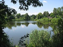
The shallow, undulating ground moraine landscapes of the Barnim are relatively poor in lakes , although they belong to the young moraine region . Isolated lakes are only found in isolated cases within the plateau, such as the Haussee near Seefeld (Gem. Werneuchen ) or the White Lake in Berlin-Weißensee . Located within the outwash plains of are due to the spillage and subsequent Austaus Toteises frequent lakes. The lake area around Wandlitz is particularly well known.
Most of the lakes within the Barnim are located in glacial channels . In most cases they are elongated and show an orientation from north / northeast to south / southwest such as a smaller chain of lakes on the eastern Barnimhang to the Stobberniederung , which extends from the Dolgensee (25 ha) over the Kesselsee (3.5 ha) and Lettinsee ( 16 ha) to the northeast to Klostersee (55 ha) near Altfriedland .
The most famous lakes in the Barnims include:
- the Liepnitzsee and the Wandlitzer See near Wandlitz
- the Gamensee in the Gamengrund
- the Straussee near Strausberg
In addition to the naturally created lakes, numerous ponds were created as mill or fish ponds. The best known are the Karower ponds in northeast Berlin.
climate
Like the surrounding regions, the Barnim lies in the transition area from the oceanic climate of Western Europe to the continental climate of Eastern Europe. Due to its modest relative height, the Niedere Barnim, in contrast to the Hohen Barnim, does not have any pronounced weather differences compared to its surrounding area. On the Hoher Barnim, too, the differences to the surrounding area are small, but can be clearly felt in certain weather conditions.
The coldest month is January with average temperatures around −1 ° C, the warmest July with approx. 18 ° C (Berlin-Buch station: January: −0.8 ° C; July: 17.8 ° C, period 1951–1980) . The Hohe Barnim is only slightly colder.
The average annual precipitation on the Niedere Barnim is a little over 550 mm with a pronounced summer maximum and winter minimum. The Oberbarnim receives noticeably more precipitation with precipitation amounts of around or just over 600 mm. There is also a secondary winter maximum there. The driest season there is spring.
The clear difference between the Hohen Barnim and the Oderbruch in the east, which is sometimes more than 100 meters lower, is interesting for the climate . A comparatively clear rain shadow is noticeable there, which is reinforced by the heights of Lebus in the south and the heights around Chorin in the north-west. While the Hohe Barnim receives a comparatively high amount of precipitation by Brandenburg standards, the Oderbruch in its rain shadow is one of the driest regions in Germany (from a climatic point of view) with precipitation amounts well below 500 mm.
Settlement history
Paleolithic, Slavs, etymology
Traces of settlement can be found in Barnim for the period of the fading glaciation in the Upper Palaeolithic . In doing so, hunters and gatherers mainly followed the course of the rivers, as evidenced by archaeological finds in the area of Oranienburg, Eberswalde, Birkenwerder or on the Tegeler Fließ in northern Berlin. Around 6000 years ago, with the development of agriculture, the first permanent settlements appeared on the streams and rivers . Finds of bronze sickles and stone troughs from western Barnim are from the younger Bronze Age . In the urban area of Strausberg a Bronze Age settlement from the years 1200–700 BC has been proven.
The Germanic tribe of the Semnones settled here . After their emigration, the Slavic tribes of the Sprewanen and probably the Rezanen , who sat near Biesenthal / Wandlitz , followed in the 6th and 7th centuries . There was an extensive Slavic castle complex on the Finow river near Biesenthal.
Barnim is a common name in Slavonic, see Barnim I. or List of the Dukes of Pomerania . According to the Märkischer Fürstenchronik, the Barnim was built by the Margraves Johann I and Otto III. of Brandenburg taken over by the Pomeranian Duke Barnim around 1230 and therefore called nova terra nostra Barnem . In 1986, Wolfgang H. Fritze declared this hypothesis to be the most likely based on the current state of research.
Settlements of the plateau from 1230
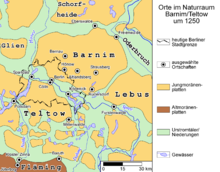
While the lowlands around the and the few rivers on the Barnim were preferred locations for the establishment of villages and fortifications until the Slavic period, the first consistent settlement of the plateau began in the 1230s under the jointly ruling Ascanian margrave Johann I . and Otto III. in the course of the German state expansion to the east. The Wettin Margraves of Meissen also carried out corresponding settlement activities . While the Ascanians had advanced over the northern edge of the Oberbarnim via Oranienburg to roughly Strausberg, the Wettins advanced from the south via their castles in Mittenwalde and Köpenick to the Niederbarnim. The question of sovereignty over these settlements led to the battles for the Barnim and Teltow, the Teltow War between 1239 and 1245, which the Ascanians won.
According to recent investigations, the Wettins under the Meissen margrave Heinrich the Illustrious tried very probably with a wreath of villages around Hönow and Altlandsberg northeast of today's Berlin to establish a rule on the Barnim. In addition, the rival of the Ascanians, the ore monastery of Magdeburg under Wilbrand von Käfernburg , owned the plateau. The Zinna Cistercian monastery, which they founded near Jüterbog in 1180 , owned extensive land around Rüdersdorf near Berlin , where the monks founded the Rüdersdorf limestone quarry, which was still important until recently .
After the Teltow War, the Brandenburg margraves ruled the Barnim. Nevertheless, a large part of the southwestern Barnim around Rüdersdorf up to the Stobberbach / Löcknitz line until secularization remained in the possession of the Zinna monastery. In a document from 1247, Johann I and Otto III confirmed. the monastery Zinna expressly the property on the Barnim.
To stabilize their rule, the Ascanians founded the Chorin monastery and the Friedland women's monastery in the middle of the 13th century . Chorin and the ruins of Friedland with the monastery church are considered to be the most important medieval monastery buildings in the region in terms of architectural history.
Settlement wave after the Thirty Years War
Until the strong growth of Berlin at the end of the 19th century, the Barnim remained relatively sparsely populated. After the Thirty Years' War there was an even bigger wave of settlements, especially with Dutch colonists who helped drain the Havelbruch area. However, these movements as well as the tax- and tax-privileged colonist villages remained largely limited to the river and canal areas in the Frederician era .
reception
The Barnim-Gymnasium Berlin is named after the landscape.
literature
- Brandenburg name book, part 5: The place names of Barnim . Edit v. Gerhard Schlimpert , Weimar 1984.
- Wolfgang H. Fritze: On the interpretation and original relationship of the landscape name "Barnim". In: Yearbook for Brandenburg State History , 37 (1986), pp. 41–50.
- L. Lippstreu, N. Hermsdorf, A. Sonntag: Geological overview map of the state of Brandenburg 1: 300,000 - explanations. Potsdam 1997, ISBN 3-7490-4576-3 .
- Carsten Rasmus, Bettina Klaehne: Hiking and nature guides in the Barnim Nature Park. KlaRas-Verlag, Berlin 2001. ISBN 3-933135-09-5 .
- Werner Stackebrandt, Volker Manhenke (Ed.): Atlas for the geology of Brandenburg . State Office for Geosciences and Raw Materials Brandenburg (today: State Office for Mining, Geology and Raw Materials Brandenburg, LBGR), 2nd edition, 142 pages, 43 maps, Kleinmachnow 2002, ISBN 3-9808157-0-6 .
- Reinhard E. Fischer : The place names of the states of Brandenburg and Berlin . Volume 13 of the Brandenburg Historical Studies on behalf of the Brandenburg Historical Commission, be.bra Wissenschaft verlag Berlin-Brandenburg 2005, ISBN 3-937233-30-X , ISSN 1860-2436 , page 43.
- Ludger Gailing, Karl-Dieter Keim: Analysis of informal and decentralized institutions and public governance with a cultural landscape background in the example region of Barnim. Berlin-Brandenburg Academy of Sciences, Materials of the Interdisciplinary Working Group Future- Oriented Use of Rural Areas (LandInnovation), No. 6, Berlin, 2006 bbaw.de (PDF; 1.3 MB)
Web links
Individual evidence
- ↑ Information on the soil associations. State Office for Mining, Geology and Raw Materials of the State of Brandenburg
- ↑ Data from M. Hendl: The climate of the North German lowlands . In: H. Liedtke, J. Marcinek (Ed.): Physical geography of Germany . Gotha 1994, ISBN 3-623-00840-0 , 559 pp.
- ↑ Publius Cornelius Tacitus : De origine et situ Germanorum liber , 39. In: Manfred Fuhrmann: Germania , p. 55
- ↑ (Land) rule and (land) ownership must be distinguished from one another. The question of who brought the Zinna monastery to the Barnim (Archbishopric Magdeburg or the Wettiners) is just as controversial as the "Magdeburg Hypothesis" by Rolf Barthel (in the BNB Barnim), with which a temporary rule of the archbishopric on the Barnim is asserted.
- ↑ Helmut Assing : Who brought the Zinna Monastery to what is now Barnim? A new issue. In: Dieter Pötschke (Ed.) History and Law of the Cistercians . Studies on the history, art and culture of the Cistercians, Volume 2. Lukas Verlag, Berlin 1997, pp. 64–77 ISBN 3-931836-05-3
- ^ Stephan Warnatsch: History of the Lehnin Monastery 1180–1542. Studies on the history, art and culture of the Cistercians. Vol. 12.2., Index list. Lukas Verlag, Berlin 2000, entry no.91 ISBN 3-931836-46-0 ISBN 3-931836-45-2
- ↑ Uta Puls: Altfriedland . In: H. Jürgen Feuerstake, Oliver H. Schmidt (Ed.): The Cistercians and their monasteries in Brandenburg. A cultural, historical and tourist guide. Revised and expanded 2nd edition, Lukas Verlag, Berlin 2005, p. 52ff ISBN 3-936872-23-6
Coordinates: 52 ° 40 ′ 0 ″ N , 14 ° 15 ′ 0 ″ E

