
Tegeler Fliess
| Tegeler Fliess | ||
 Course of the Tegeler River |
||
| Data | ||
| Water code | DE : 58196 | |
| location | North Brandenburg , North Berlin ; Germany | |
| River system | Elbe | |
| Drain over | Havel → Elbe → North Sea | |
| source | at Basdorf and Zühlsdorf coordinates in the course section |
|
| muzzle | in Berlin-Tegel in the Tegeler See Coordinates: 52 ° 35 ′ 22 ″ N , 13 ° 16 ′ 14 ″ E 52 ° 35 ′ 22 ″ N , 13 ° 16 ′ 14 ″ E
|
|
| length | 30.4 km | |
| Discharge at the St.-Joseph-Steg A Eo gauge : 121 km² Location: 1.2 km above the mouth |
NNQ (08/18/1989) MNQ 1986–1999 MQ 1986–1999 Mq 1986–1999 MHQ 1986–1999 HHQ (02/10/1987) |
81 l / s 135 l / s 418 l / s 3.5 l / (s km²) 1.35 m³ / s 2.5 m³ / s |
| Right tributaries | Kindelfliess | |
| Big cities | Berlin | |
| Communities | Wandlitz , Mühlenbecker Land , Glienicke / Nordbahn | |
 View over the Tegeler Fließ valley near Lübars |
||
The Tegeler Fließ is a stream in Brandenburg or on the northern outskirts of Berlin . It has a length of 30.4 kilometers, of which 9.9 kilometers are in Berlin's urban area. Its catchment area is 172 km², of which 80.3 km² in the capital. The body of water was named after the Berlin district of Tegel .
course
The Tegeler Fließ is fed by two source streams in Brandenburg. The first ( 52 ° 43 '44 ″ N , 13 ° 27 ′ 30 ″ E ) rises in the Basdorfer Heide northeast of Basdorf and forms the mill pond at Dammsmühle Castle downwards . The second ( 52 ° 42 ′ 42 ″ N , 13 ° 23 ′ 30 ″ E ) comes from the Bahrenbruch, a moorland in the Mühlenbeck Heath south of Zühlsdorf . The two tributaries unite in Lake Mühlenbeck on the border of the Barnim and Oberhavel districts . In the first district the water flows through the municipality of Wandlitz , in the latter almost the entire width of the municipality of Mühlenbecker Land and the edge of the municipality of Glienicke / Nordbahn .
The stream flows past Buchhorst and between Woltersdorf and Mühlenbeck before it forms the state border for around eight kilometers behind Mönchmühle or west of the Berlin Outer Ring railway line . The river separates the Brandenburg towns of Schildow and Glienicke / Nordbahn from the Berlin districts of Blankenfelde in the Pankow district and Lübars in the Reinickendorf district . The further course leads through Hermsdorf (widening to Hermsdorfer See ) and Waidmannslust . In Tegel the confluence with the Tegeler See is located , the drainage thus takes place in the Havel . Up to here around 25 meters in altitude have been overcome. In this area, the river to the Tegeler Hafen was extended and the end of the north ditch lies .
- gallery
The Tegeler Hafenbrücke ("Sechserbrücke") spans the Tegeler Hafen and the Tegeler Fließ (left in the picture)

Looking east from the bridge at the northern end of the Titusweg

In Hermsdorf, the B 96 crosses the Tegeler Fließ at a former mill

Tegeler Fließ in the "Tegeler Fließ" nature reserve north of the Lübarser fields

Remnants of the former GDR border security at Tegeler Fließ


history
During the last Ice Age , a meltwater channel formed under a glacier and thus formed the valley of the Tegeler River. The erosion channel extended from the Summter and Mühlenbecker lakes to the Tegeler See. The oldest human traces in the Berlin area were found on the edge of the brook. Stone Age hunters captured reindeer here from deer passes . Several settlements from the Bronze Age were grouped on the sand ridge by the river. An unearthed tar furnace from the 13th century shows that more than 100 years old pine trees grew in the forests , because only these were used for tar smelling. During this time the villages Mönchmühle (first mentioned 1242), Woltersdorf (1242), Lübars (1247), Blankenfelde (1284), Basdorf (1302), Tegel (1322), Hermsdorf (1349), Mühlenbeck (1375), Schildow (1375) ) and Zühlsdorf (1375). One of the reasons for founding the town was certainly the great abundance of fish at that time.
The construction of the watermills in Schildow and Tegel (today's Humboldt mill) around 1450 led to water regulation, the creation of the Hermsdorf lake and Tegeler pond as well as peatland . The high groundwater level and the floods prevented the re-emergence of broken forest. The dampness of the fens allowed only extensive use of the meadows. The farmers were dissatisfied with the late or completely prevented mowing. Drainage ditches , whose close-knit network can be seen on a map from 1839, should help.
Extensive peat has been cut since the 19th century , one of the results is the Köppchensee . There is also evidence of extraction in the area of the Hermsdorfer See and in the NSG Kalktufgelände on the Tegler Fließ . In addition, from 1854 clay was mined at Hermsdorf and burned into bricks . The Hermsdorf clay pits on Seebadstrasse and the Ziegeleigraben bear witness to this. At the end of the 19th century, sewage fields were created in the north-east of Berlin . The water was discharged into the Tegeler See via the Tegeler Fließ . After the cessation of trickling in 1985, the high levels of nutrients and pollutants fell. Due to the reduced amount of runoff , the spring activity on the valley slopes also decreased and the lowland became significantly drier.
Until 1990 the state border between the GDR and West Berlin ran along a section of the Tegeler River . The border security systems between Schildow and Glienicke / Nordbahn in the north and Lübars and Hermsdorf in the south were not located directly on the water, but on the northern edge of the surrounding meadow landscape. The course of the stream between Schildow and Blankenfelde was secured with a water barrier. Remnants of it can still be found today on the Berlin Wall Trail near the Köppchensee.
environment

The natural meandering Tegeler Fließ shapes the landscape. The highly complex habitat includes springs and spring brooks, spring and fens , dry slopes , wet, damp and fresh meadows, natural alder and gray willow quarries, ponds , lakes and silting areas . The river itself appears as a forest or meadow stream with different flow stretches and oxbow lakes . Most of the area is located in the national nature park Barnim . In Brandenburg it touches the Westbarnim landscape protection area, in Berlin the LSG Tegeler Fließ as well as the NSG Kalktufgelände on Tegler Fließ and the NSG Niedermoorwiesen on Tegeler Fließ. The Tegeler Fließal is registered as a Natura 2000 area in both federal states . In the Berlin part there are twelve habitat types and six animal species that are protected under the Habitats Directive , as well as nine species from the EU Bird Protection Directive . Remarkable for a city of millions.
flora

The species-rich aquatic vegetation includes u. a. various spawning herbs and water stars as well as the common horn leaf, a flowing form of the simple hedgehog's cob . Hermsdorfer lake and Luebars are well developed, diverse Hochstaudenfluren damp locations with Real bindweed , Genuine meadowsweet , vulgar Wasserdost , knotty figwort and various fireweed . The Großer Torfstich on Eichwerdersteg, a naturally nutrient-rich lake, has a well-developed silting zone and a species-rich world of aquatic plants. There are a number of different meadow communities:
| Pipe grass meadows | NSG Kalktuffgelände on Tegeler Fließ (here particularly rich in species), In den Langen Hufen, on Hermsdorfer See | Broad-leaved orchid , three-leaved fever clover , magnificent carnation , common devil's bite , meadow knotweed and many other endangered species |
| Flatland hay meadows | drier locations throughout | |
| Sand dry grass | dry slopes | Mountain hairline , sagebrush , common carnation , Carthusian carnation , sand straw flower , sheep fescue , silver grass , scabiosa knapweed , petite schiller grass |
| subcontinental blue schiller grass lawns | small areas on dry slopes |
Among the forest communities, the alder, ash and alluvial softwood forests are particularly worthy of protection. Larger stocks have developed on Lake Hermsdorfer. The other locations are significantly smaller and less natural because of the adjacent use and the changed water dynamics. The lowland is home to numerous types of willow , the most common being the gray willow , but wicker , laurel , purple and smith willow can also be found. Other species are likely to occur, but even botanists have problems identifying them because the different species can interbreed. One problem is the invasive spread of neophytes , so glandular balsam , goldenrod , Jerusalem artichoke or ash maple dominate in some sections .
fauna

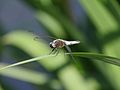
From the end of May the banded demoiselle flies along the river, its larvae grew up in the water. A multitude of insects are at home in the flower-rich meadows . a. Bees , bumblebees , hover flies and wasps . Among the butterflies are the Red List species of sweet clover, ram and birch fork-tail . Even butterflies that were considered to be extinct in Berlin have been identified, such as the alluvial forest autumn owl, the grove mother-of-pearl butterfly and the celadon owl .
17 of a total of 29 Berlin fish species live in the brook, in addition to the main fish, the roach , especially eels , pike , carp , tench , sticklebacks and pikeperch . Of the thirteen Berlin amphibians and reptiles , eleven are found in the area.
Representatives of birdlife include Beutelmeise , Whinchat , kingfisher , gray wagtail , Woodlark , Gray Crane , middle spotted woodpecker , red-backed shrike , marsh harrier , Sedge Warbler , Black Kite , Black Woodpecker , Barred Warbler , Common Pochard , corncrake , water rail , white stork and honey buzzard .
The following migratory birds stop at times also in the valley: Lesser Spotted Woodpecker , Golden Oriole , Yellow Wagtail and Warbler .
The otter usually only reveals itself through its tracks and the water shrew inhabits the embankments.
Since May 2015 beyond nine are water buffaloes for grazing of protected natural marsh grass surfaces in a 19-hectare fenced area between the Egidybrücke in the south and the northern fen meadows used. In August 2015, the herd was expanded to include four more water buffalo.
- Animals admitted in the Tegeler Fließal protected area

Goldammer in Lübars
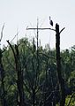
Gray heron on dead tree

Crane flying low in the limestone tufa terrain
Top spot -Männchen the southern shore of Lake Hermsdorf

Mandarin pelvis in the Tegeler Fließ
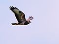
Common buzzard in Lübars

Mallard pair in the Tegeler Fließ


tourism
Especially between Hermsdorf and Lübars there is an unspoilt stream meadow landscape, as it was once typical for the entire Tegeler Fliess. The Eichwerdersteg, a 145 meter long boardwalk , leads directly through the floodplain, which is reminiscent of the large Eastern European river bogs . There is a nature trail with information boards and the Lübars outdoor pool on the Ziegeleisee . Further sights are the Lübarser village center and the nature reserve Niedermoorwiesen. Information boards provide information in the local recreation area. The Barnim Dörferweg crosses southwest of the Köppchensee - begins in the Wuhletal and ends at Tegeler See - and the Berlin Wall Trail . The phases of apple blossom in May and harvest in early autumn are worth seeing .
Lübars and the slope edge at Köppchensee offer views down into the valley of the Tegeler Fließ. Due to its sensitivity, the NSG limestone tufa area is only accessible to a very limited extent; an impression can be gained from the outskirts of Blankenfelde. The hiking trail marked with a green horizontal line leads, initially parallel to the German Clay Road , through the more developed southern part of the municipality of Mühlenbecker Land to the Mühlenbecker See. The Dammsmühle Castle in the middle of beech and mixed forests is followed by the Museum of the Heidekrautbahn in Basdorf and finally the area of the Basdorfer Quelle. Via an intermediate section on the Summter See, the same marking also leads to the vicinity of the Zühlsdorf spring.
literature
- Michael Böhme: Structure of the waters of the Wuhle, Panke and Tegeler Fliess. Berlin 1998. (Michael Böhme: Water structure of Wuhle, Panke and Tegeler Fließ (pdf; 820 KB) . Archived from the original on December 29, 2016.)
- Berlin Senate Department for Urban Development (Ed.): Of course Berlin. Nature conservation and Natura 2000 areas in Berlin. 2nd Edition. Verlag Natur und Text, Rangsdorf 2009, ISBN 978-3-9810058-9-9 , pp. 22-39.
Web links
Individual evidence
- ^ German Hydrological Yearbook Elbe Region, Part II 1999 Brandenburg State Environment Agency, p. 103, accessed on November 3, 2018, at: lugv.brandenburg.de (PDF, German).
- ↑ Senate Department for Urban Development, inventory, p. 10. (PDF; 1.9 MB)
- ↑ a b c d e f g h i j k l Berlin Senate Department for Urban Development (ed.): Natura 2000 area Tegeler Fliessal. In: Of course Berlin. Nature conservation and Natura 2000 areas in Berlin. 2nd Edition. Verlag Natur und Text, Rangsdorf 2009, ISBN 978-3-9810058-9-9 , pp. 22-27. Digital edition in: Berlin Senate Department for Urban Development , short version.
- ↑ a b c d e Berlin Senate Department for Urban Development (ed.): Nature reserve Niedermoorwiesen am Tegeler Fließ. In: Of course Berlin. Nature conservation and Natura 2000 areas in Berlin. 2nd Edition. Verlag Natur und Text, Rangsdorf 2009, ISBN 978-3-9810058-9-9 , pp. 28–33. Digital edition in: Berlin Senate Department for Urban Development , short version.
- ↑ Reinhard E. Fischer : The place names of the states of Brandenburg and Berlin. Age - origin - meaning. (= Brandenburg historical studies. Volume 13). be.bra Wissenschaft Verlag , Berlin 2005, ISBN 3-937233-30-X .
- ↑ a b c d Berlin Senate Department for Urban Development (ed.): Kalktufgelände nature reserve on the Tegeler Fließ. In: Of course Berlin. Nature conservation and Natura 2000 areas in Berlin. 2nd Edition. Verlag Natur und Text, Rangsdorf 2009, ISBN 978-3-9810058-9-9 , pp. 34–39. Digital edition in: Berlin Senate Department for Urban Development , short version.
- ↑ Water buffalo as lawn mowers. In: Berliner Abendblatt . Retrieved November 10, 2016.
- ↑ Wasserbüffel am Tegeler Fließ: A grazing project on gvb.wasserbueffel.square7.de. Retrieved November 10, 2016.
- ↑ Even more water buffalo in the river: nature conservation project is being expanded. In: Berliner Woche , accessed on November 10, 2016.
- ↑ Reinforcement in Tegel: These water buffalos graze for nature conservation. In: BZ , August 3, 2015, accessed November 10, 2016.
- ↑ Rolf Bernstengel: Hike on the Tegeler Fließ and the Eichwerdersteg nature trail. In: Pharus-Plan Northern Berlin districts and southern Barnim Nature Park. Pharus-Plan , Berlin 2006, ISBN 3-86514-097-1 .
- ↑ Cycle touring and hiking map of the Barnim Nature Park, Wandlitzer See and the surrounding area. 3. Edition. Publishing house Dr. Andreas Barthel, Borsdorf near Leipzig, runs until 2015, ISBN 978-3-89591-090-6 .
- ^ Kristine Jaath: Wandlitz and surroundings. In: Brandenburg. On the way between the Elbe and the Oder. 1st edition. Trescher Verlag , Berlin 2010, ISBN 978-3-89794-150-2 , pp. 197-202.

X-ray valley cutting area | Biesenthal Basin | Width fenn | Buckowseerinne | Lazy meadows near Bernau | Fettseemoor | Finowtal – Pregnitzfließ | Great Lubowsee | Grumsiner Forst / Redernswalde | Kanonenberg and Schloßberg, Schäfergrund | Kienhorst / Köllnseen / Eichheide | Ladeburger Schäferpfühle | Lubowsee | Lower Oder Valley National Park | Redernswalde nature development area | Niederoderbruch | Nonnenfließ – Schwärzetal | Oberseemoor | Pimpinellenberg | Plagefenn | Poratzer moraine landscape | Rabenluch | Rarang lakes | Rapid Havel | Schönerlinder ponds | Schönower Heide | Tegeler Fließal | Torfstich Klosterfelde | Juniper hunting | Weesower Luch | Wischsee

Welsengraben biotope network | Eichwerder Moorwiesen | Gehron Lake | Hares | Häsener Luch | Kastavenseen-Molkenkammersee | Kindelsee Springluch | Kleine Schorfheide | Klienitz | Kremmener Luch | Kremmener See | Liebenberger Bruch | Lubowsee | Moddersee | Lake Moncaprice | Upper Rhinluch | Pinnower See | Rapid Havel | Schönerlinder ponds | Swimming harbor meadows | Stechlin | Tegeler Fließal | Thymes