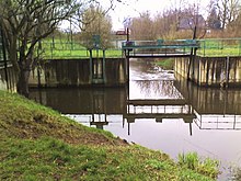
North ditch
The Nordgraben is a drainage ditch in the north of the city of Berlin , which connects the Panke with the Tegeler See .
location
The ditch begins near the Blankenburg S-Bahn station on the Pankebecken south of Bahnhofstrasse. It runs through the Berlin districts of French Buchholz , Nordend and Rosenthal and forms the border between the Märkisches Viertel and Wilhelmsruh , among other things . The further course leads through Wittenau and Borsigwalde and ends in Tegel as a tributary of the Tegeler Fließ into the Tegeler See. Since it is guided at the same height, it sometimes cuts up to ten meters into the terrain.
history
The ditch was built between 1927 and 1938 in order to be able to better regulate the water level of the Panke as a rainwater drainage system. In particular, the supply of trickle water into the Panke was one reason for the increased amount of water. The Panke, which was overloaded during heavy rainfall, was relieved by this ditch. At the same time, the north ditch was designed as an advance service for the planned Berlin north canal.
However, the construction had a negative impact on the natural flow of groundwater . The groundwater level was also significantly lowered by the construction of the north trench. A groundwater observation point in Blankenfelde has been falling dry since 1938. On July 6, 1980, however, after heavy rains, the Panke rose again over its banks. Piling up sandbags prevented major damage.

When the Rieselfeldwirtschaft was discontinued on Pankower Flur in 1980 , the north ditch was no longer necessary and it lost its inflow. Since then, the water level has been regulated by water management.
A few smaller trenches flow towards the north trench. The Zingergraben is interrupted on its original course to the Panke because the north ditch cut through the course. The tributaries to the rest of the (southern) Zingergraben, however, also reach the beginning of the northern trench via the northern part of the Panke. Likewise, water flows from Lietzengraben and Kreuzgraben over the Panke to the Blankenburger Pankebecken and is distributed here by the water management through a weir west of Blankenburg to Nordgraben and Panke. The Zingergraben finds a new meaning through the Zingergraben green corridor - a landscape protection area in the north of Pankow. In the Wittenau area, the Packereigraben and the Kesselpfuhlgraben flow into the Nordgraben. The Klärwerksableiter of the sewage treatment plant Schönerlinde also drains into the North ditch.
Traffic situation
After German reunification , the Senate of Berlin planned a relief road in the north (north bypass) with the drawing up of the Berlin zoning plan in 1994, which was to run largely along the north ditch. The project was particularly controversial among environmentalists, as it would have polluted or destroyed the rudimentary natural areas that still existed and the newly created green spaces. On the other hand, road traffic in the north has developed considerably since the fall of the Berlin Wall and runs on roads that were not intended for this heavier load. In 2003, the planned north connection between Reinickendorf and Pankow was abandoned due to a change in the land use plan, the reason given was the lower growth in traffic volume compared to the planning. In 2008, the then Senate officially declared the project over.
In 2005, in the Pankow district, a road connection for the Pankow-Park industrial site , the former Bergmann-Borsig factory , was established as an extension of the street Am Nordgraben . This dead end was inaugurated on June 1, 2006 and was named Heinz-Brandt-Straße after the resistance fighter Heinz Brandt .
Web links
Individual evidence
- ↑ A hike on the Zingergraben
- ↑ Information about the Nordgraben on the website of the Senate Department for the Environment
- ↑ Former north bypass (Reinickendorf / Pankow) planning 29/95 (PDF; 252 kB)
Coordinates: 52 ° 35 ′ 23 " N , 13 ° 18 ′ 43" E


