Packing trenches
| Packing trenches | ||
|
Mouth of the Packereigraben in the Steinbergsee |
||
| Data | ||
| Water code | DE : 5819686 | |
| location | Germany Berlin | |
| River system | Elbe | |
| Drain over | Nordgraben → Tegeler Fließ → Havel → Elbe → North Sea | |
| muzzle | Nordgraben coordinates: 52 ° 35 ′ 40 " N , 13 ° 18 ′ 4" E 52 ° 35 ′ 40 " N , 13 ° 18 ′ 4" E
|
|
| length | 6.1 km | |
| Catchment area | 6.974 km² | |
| Flowing lakes | Steinbergsee | |
| Big cities | Berlin | |
|
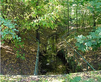
View of the packing ditch from Avenue Charles de Gaulle in Wittenau |
||
The Packereigraben is a small body of water in the north of Berlin .
It is fed from the Seggeluch basin and the Klötz basin near the Märkisches Viertel . After crossing Bundesstraße 96 at the former Volta works (now a hardware store) , it forms the border between the Waidmannslust district and the Cité Foch in the Wittenau district . In the Steinbergpark it flows through the Steinbergsee and finally flows into the Nordgraben opposite the Havelmüllerweg . Until 1929 the Packereigraben flowed directly into the Tegeler Fließ . Its course was not changed until the north trench was built.
Individual evidence
- ↑ a b River directory gewnet25 (Version 4.2, November 8, 2016) ( Memento from April 18, 2019 in the Internet Archive ) at the Ministry for Rural Development, Environment and Agriculture of the State of Brandenburg.
Web links
Commons : Packereigraben - collection of pictures, videos and audio files
- Packereigraben hiking trail (PDF; 86 kB)
- Trenches and waters on the website "Wittenau History"

