North Canal (Berlin)
| North channel | |
|---|---|
| length | 30 km |
| Built | (planned around 1900) |
| Historical precursors | North ditch |
| Used river | Havel |
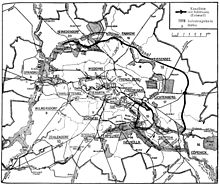
Nordkanal ( ) was the designation name for an approximately 30 km long canal , which should support the economic development of the areas in northeast Berlin . The canal was intended as an equivalent to the Teltow Canal , which was built between 1900 and 1906, in the south of Berlin, but was never realized. One of the preliminary work is the north ditch , which connects Panke and Tegeler See .
history
As early as the 1880s there were first considerations for a northern artificial waterway. For the Schinkel competition of 1886, the engineering task was given to design a port and canal facility for the north of Berlin . Five drafts were received for this task. The prize and medal were awarded to Friedrich Gerlach , whose designs are preserved in the Architecture Museum of the Technical University of Berlin . According to his design, the canal should branch off from the Berlin-Spandau shipping canal and lead via a multi-chamber lock to a new large harbor basin in the area between Wisbyer Straße and Schönhauser Allee . The idea of performing a necessary swiveling of the canal with the ability to turn the ships, which should be spanned by a road bridge, was interesting. The coordinates roughly show the location of the planned reversible basin.
Up until around 1900, the Berlin economy continued to raise demands for traffic engineering to open up north-east Berlin by water.
After the formation of the city of Greater Berlin in 1920, Berlin put the plan to build a north canal again, with a modified route, to alleviate the labor shortage and to stimulate the economy. The canal was to begin below Köpenick on the Spree, cut through the former urban Rieselfelder and Wuhlheide , then through Biesdorf , Lichtenberg , Weißensee , Hohenschönhausen , Pankow , Blankenburg , Buchholz , Reinickendorf , Rosenthal , Wittenau and Tegel and finally into the Tegeler See flow out. The canal would have had a length of 31 km. It should have two locks and be expanded for 1000-ton ships.
The shift in planning priorities during the Third Reich to the world capital Germania ultimately led to the project being abandoned entirely. The different routes are ruled out over the years due to increasingly dense development.
literature
- Fritz Herbst: The plan of a Berlin north canal . In: Zentralblatt der Bauverwaltung , Volume 44, No. 11 (March 12, 1924), pp. 85–86.
- The north canal should lead from Köpenick to Tegel / city expansion planned since the beginning of the century: A port was planned at the Biesdorfer Kreuz . In: Berliner Zeitung , June 10, 1995
- The empire and the Weimar Republic planned a Berlin north canal between Köpenick and Tegel: river ships were to cross the Wuhlheide . In: Berliner Zeitung , December 16, 1995.
- Joachim Bennewitz: A rural community wants to build a railway . In: Berlin monthly magazine ( Luisenstädtischer Bildungsverein ) . Issue 11, 2000, ISSN 0944-5560 , p. 42-50 ( luise-berlin.de ).
- Günter Peters: Marzahn as a port city? In: Berlin monthly magazine ( Luisenstädtischer Bildungsverein ) . Issue 1, 1996, ISSN 0944-5560 , p. 86-87 ( luise-berlin.de ).
Web links
- Friedrich Gerlach: Port and canal system, Berlin-Gesundbrunnen (north canal). Schinkel competition 1886 . Architecture museum of the Technical University of Berlin
- Historical town planning - Documentation on the occasion of the exhibition Historical town planning for the north-east of Berlin from November 17, 1997 to August 11, 1998.
Individual evidence
- ↑ Wittenau history
- ↑ Centralblatt der Bauverwaltung , Volume 6, No. 1 (January 2, 1886), p. 7.
- ^ Centralblatt der Bauverwaltung , Volume 6, No. 10 (March 6, 1886), p. 96.
- ↑ North Canal Project, Sheet 1: Routing
- ^ Fritz Herbst: The plan of a Berlin north canal.
Coordinates: 52 ° 33 '23 " N , 13 ° 22' 25" E
