
Teltow Canal
| Teltow Canal | |||||||||||||||||||||||||||||||||||||||||||||||||||||||||||||||||||||||||||||||||||||||||||||||||||||||||||||||||||||||||||||||||||||||||||||||||||||||||||||||||||||||||||||||||||||||||||||||||||||||||||||||||||||||||||||||||||||||||||||||||||||||||||||||||||||||||||||||||||||||||||||||||||||||||||||||||||||||||||||||||||||||||||||||||||||||||||||||||||||||||||||||||||||||||||||||||
|---|---|---|---|---|---|---|---|---|---|---|---|---|---|---|---|---|---|---|---|---|---|---|---|---|---|---|---|---|---|---|---|---|---|---|---|---|---|---|---|---|---|---|---|---|---|---|---|---|---|---|---|---|---|---|---|---|---|---|---|---|---|---|---|---|---|---|---|---|---|---|---|---|---|---|---|---|---|---|---|---|---|---|---|---|---|---|---|---|---|---|---|---|---|---|---|---|---|---|---|---|---|---|---|---|---|---|---|---|---|---|---|---|---|---|---|---|---|---|---|---|---|---|---|---|---|---|---|---|---|---|---|---|---|---|---|---|---|---|---|---|---|---|---|---|---|---|---|---|---|---|---|---|---|---|---|---|---|---|---|---|---|---|---|---|---|---|---|---|---|---|---|---|---|---|---|---|---|---|---|---|---|---|---|---|---|---|---|---|---|---|---|---|---|---|---|---|---|---|---|---|---|---|---|---|---|---|---|---|---|---|---|---|---|---|---|---|---|---|---|---|---|---|---|---|---|---|---|---|---|---|---|---|---|---|---|---|---|---|---|---|---|---|---|---|---|---|---|---|---|---|---|---|---|---|---|---|---|---|---|---|---|---|---|---|---|---|---|---|---|---|---|---|---|---|---|---|---|---|---|---|---|---|---|---|---|---|---|---|---|---|---|---|---|---|---|---|---|---|---|---|---|---|---|---|---|---|---|---|---|---|---|---|---|---|---|---|---|---|---|---|---|---|---|---|---|---|---|---|---|---|---|---|---|---|---|---|---|---|---|---|---|---|---|---|---|---|---|---|---|---|---|---|---|---|---|---|---|---|---|---|---|---|---|---|---|---|---|---|---|---|---|---|---|---|---|---|---|---|---|---|---|---|---|---|---|
 |
|||||||||||||||||||||||||||||||||||||||||||||||||||||||||||||||||||||||||||||||||||||||||||||||||||||||||||||||||||||||||||||||||||||||||||||||||||||||||||||||||||||||||||||||||||||||||||||||||||||||||||||||||||||||||||||||||||||||||||||||||||||||||||||||||||||||||||||||||||||||||||||||||||||||||||||||||||||||||||||||||||||||||||||||||||||||||||||||||||||||||||||||||||||||||||||||||
| abbreviation | TeK | ||||||||||||||||||||||||||||||||||||||||||||||||||||||||||||||||||||||||||||||||||||||||||||||||||||||||||||||||||||||||||||||||||||||||||||||||||||||||||||||||||||||||||||||||||||||||||||||||||||||||||||||||||||||||||||||||||||||||||||||||||||||||||||||||||||||||||||||||||||||||||||||||||||||||||||||||||||||||||||||||||||||||||||||||||||||||||||||||||||||||||||||||||||||||||||||||
| location |
Berlin , Teltow , Kleinmachnow , Stahnsdorf , Potsdam |
||||||||||||||||||||||||||||||||||||||||||||||||||||||||||||||||||||||||||||||||||||||||||||||||||||||||||||||||||||||||||||||||||||||||||||||||||||||||||||||||||||||||||||||||||||||||||||||||||||||||||||||||||||||||||||||||||||||||||||||||||||||||||||||||||||||||||||||||||||||||||||||||||||||||||||||||||||||||||||||||||||||||||||||||||||||||||||||||||||||||||||||||||||||||||||||||
| length | 38.39 km | ||||||||||||||||||||||||||||||||||||||||||||||||||||||||||||||||||||||||||||||||||||||||||||||||||||||||||||||||||||||||||||||||||||||||||||||||||||||||||||||||||||||||||||||||||||||||||||||||||||||||||||||||||||||||||||||||||||||||||||||||||||||||||||||||||||||||||||||||||||||||||||||||||||||||||||||||||||||||||||||||||||||||||||||||||||||||||||||||||||||||||||||||||||||||||||||||
| Built | 1900-1906 | ||||||||||||||||||||||||||||||||||||||||||||||||||||||||||||||||||||||||||||||||||||||||||||||||||||||||||||||||||||||||||||||||||||||||||||||||||||||||||||||||||||||||||||||||||||||||||||||||||||||||||||||||||||||||||||||||||||||||||||||||||||||||||||||||||||||||||||||||||||||||||||||||||||||||||||||||||||||||||||||||||||||||||||||||||||||||||||||||||||||||||||||||||||||||||||||||
| class | IV | ||||||||||||||||||||||||||||||||||||||||||||||||||||||||||||||||||||||||||||||||||||||||||||||||||||||||||||||||||||||||||||||||||||||||||||||||||||||||||||||||||||||||||||||||||||||||||||||||||||||||||||||||||||||||||||||||||||||||||||||||||||||||||||||||||||||||||||||||||||||||||||||||||||||||||||||||||||||||||||||||||||||||||||||||||||||||||||||||||||||||||||||||||||||||||||||||
| Beginning | Glienicker Lake | ||||||||||||||||||||||||||||||||||||||||||||||||||||||||||||||||||||||||||||||||||||||||||||||||||||||||||||||||||||||||||||||||||||||||||||||||||||||||||||||||||||||||||||||||||||||||||||||||||||||||||||||||||||||||||||||||||||||||||||||||||||||||||||||||||||||||||||||||||||||||||||||||||||||||||||||||||||||||||||||||||||||||||||||||||||||||||||||||||||||||||||||||||||||||||||||||
| The End | Dahme between Grünau and Köpenick | ||||||||||||||||||||||||||||||||||||||||||||||||||||||||||||||||||||||||||||||||||||||||||||||||||||||||||||||||||||||||||||||||||||||||||||||||||||||||||||||||||||||||||||||||||||||||||||||||||||||||||||||||||||||||||||||||||||||||||||||||||||||||||||||||||||||||||||||||||||||||||||||||||||||||||||||||||||||||||||||||||||||||||||||||||||||||||||||||||||||||||||||||||||||||||||||||
| Descent structures | Kleinmachnow lock | ||||||||||||||||||||||||||||||||||||||||||||||||||||||||||||||||||||||||||||||||||||||||||||||||||||||||||||||||||||||||||||||||||||||||||||||||||||||||||||||||||||||||||||||||||||||||||||||||||||||||||||||||||||||||||||||||||||||||||||||||||||||||||||||||||||||||||||||||||||||||||||||||||||||||||||||||||||||||||||||||||||||||||||||||||||||||||||||||||||||||||||||||||||||||||||||||
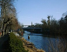
| Outstanding structures | Teltow Canal Bridges | ||||||||||||||||||||||||||||||||||||||||||||||||||||||||||||||||||||||||||||||||||||||||||||||||||||||||||||||||||||||||||||||||||||||||||||||||||||||||||||||||||||||||||||||||||||||||||||||||||||||||||||||||||||||||||||||||||||||||||||||||||||||||||||||||||||||||||||||||||||||||||||||||||||||||||||||||||||||||||||||||||||||||||||||||||||||||||||||||||||||||||||||||||||||||||||||||
|
course
|
|||||||||||||||||||||||||||||||||||||||||||||||||||||||||||||||||||||||||||||||||||||||||||||||||||||||||||||||||||||||||||||||||||||||||||||||||||||||||||||||||||||||||||||||||||||||||||||||||||||||||||||||||||||||||||||||||||||||||||||||||||||||||||||||||||||||||||||||||||||||||||||||||||||||||||||||||||||||||||||||||||||||||||||||||||||||||||||||||||||||||||||||||||||||||||||||||
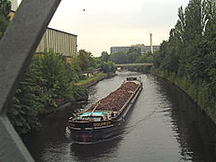
The Teltow Canal (TeK) is a 38.39 kilometer long canal in Berlin and the southern Berlin area , which was created at the beginning of the 20th century. It connects the Spree-Oder waterway ( Dahme , tributary of the Spree ) with the Lower Havel waterway ( Potsdamer Havel ). As a federal waterway of waterway class IV with restrictions, the canal runs through the federal states of Berlin and Brandenburg and partially forms their state border. Legally, the TeK still includes the federal waterways Griebnitz Canal (formerly Prinz-Friedrich-Leopold Canal ), Zehlendorfer Stich Canal and Britzer connecting canal (to the Spree) (formerly Britzer Zweigkanal). The Berlin Waterways and Shipping Office is responsible for the administration .
location

The Teltow Canal is a southern bypass of Berlin for shipping. The direction of flow defined in the inland waterways order goes from east to west. The kilometers count from west to east; it begins at the eastern end of Glienicker Lake near Potsdam - Klein Glienicke at 0.00 km and ends at 37.84 km between Köpenick and Grünau an der Dahme .
The canal begins legally at the western end of the Glienicker Lake, branching off from the Potsdamer Havel , at kilometer −0.55 and runs through the Griebnitzsee , which lies between Berlin-Wannsee and Potsdam-Babelsberg and belongs to the Havel river system. At the eastern end of the Griebnitzsee, the Griebnitzkanal branches off to the northeast to the Großer Wannsee . After passing the railway and S-Bahn route Berlin - Potsdam near Kohlhasenbrück and the A 115 motorway near Dreilinden , it reaches Stahnsdorf and then Kleinmachnow with Lake Machnower and the historic New Hakeburg . To the west, at 8.34 kilometers, is the only canal step, the Kleinmachnow lock system , with an average drop of 2.86 meters.
From Neubabelsberg to Kohlhasenbrück and between Berlin-Zehlendorf and the city of Teltow , the canal forms the state border between Berlin and Brandenburg . At kilometer 13.49 the Zehlendorf branch canal branches off to the north. From there the Teltow Canal runs through the Berlin districts of Lichterfelde , Steglitz , Lankwitz , Tempelhof and the Neukölln and Treptow-Köpenick districts to Grünau . At canal kilometer 28.30, the junction at the Britz-Ost port, the Neukölln shipping canal branches off as a state waterway to the north and the Britzer connecting canal to the east to the Spree-Oder waterway (Treptower Spree).
The ships that wanted to sail into the Spree-Oder waterway had to leave the Teltow Canal at the Britz-Ost port from 1990 and continue their journey on the 3.39-kilometer-long Britzer connecting canal to the Spree-Oder waterway. The further course of the Teltow Canal was closed between kilometers 34.1 and 36.6, as large amounts of heavily contaminated sludge from GDR times had to be removed here. This section has been navigable again since April 2000 (contrary to what is often stated), so that the connection to the Spree-Oder waterway is now also established here.
The lowest bridge clearance at medium water level is 4.50 meters. The maximum permissible unloading depth is 2.00 meters with a water depth of 2.60 meters, except in the section of canal kilometers 34.10–37.84. Only a unloading depth of 1.75 meters is permitted here. The water level is at least 37 meters wide.
history
The Teltow Canal was built on the initiative of the district administrator of the Teltow district , Ernst von Stubenrauch . For the western part of the canal, the bed of the Bäkefliee , the former Telte, was used to a large extent , which ran from Fichtenberg in Berlin-Steglitz to Griebnitzsee. Except for two small sections in Steglitz and in the nature reserve Bäketal Kleinmachnow , the Bäke has completely disappeared. The Lanke , which gave Lankwitz its name and which flowed into the Bäke at the Birkbusch , also served the engineers as a bed for the canal.
The first groundbreaking took place on December 22, 1900 in Babelsberg , the canal was put into operation on June 2, 1906 by Kaiser Wilhelm II , who was also the first to sail it with his yacht Alexandria in the area of the Kleinmachnow lock. The complete completion of the canal took a few more months due to structural problems in Lichterfelde. The canal was planned to relieve the rain and, due to the locks, time-consuming shipping traffic in the center of Berlin, brought a shortening of the routes for traffic between the Elbe and Oder by around 16 kilometers, should enable new industrial and residential settlements at the gates of Berlin and at the same time as a receiving water drainage of the record in the suburbs of Berlin located on it. At times, up to 2550 workers were employed, half of them foreigners from Eastern Europe. The Britzer connecting canal and the Neukölln shipping canal were already planned.

.jpg)

Because it soon turned out that the canal was undersized for the planned traffic, towing traffic was set up - also to protect the banks. The barges that were common at the time were pulled in the canal by electric towing locomotives. For this purpose, bridges were built in the area of the ports for the continuous tow-locomotive traffic. To maintain the waterway, the towing operation and the maintenance of the locomotives, the Teltow Canal Construction Management set up a construction harbor and building yard between the canal kilometers 11.35 and 11.54 in Schönow , from which the Teltow shipyard emerged in 1924 . The engineering office Havestadt & Contag - responsible for all canal construction - built an electrical central station on the building yard , which would later become the Schönow power station . On the Machnower See at the beginning of the Teltow Canal, no towing devices could be used due to the width of the water. The canal administration tested a special tugboat here, the electric motors of which were supplied with electrical energy via an overhead line and their own pantographs. For reasons of cost and technology, however, there was only one test ship Teltow . Electric towing operations were not resumed after 1945. A locomotive and the bow section of a barge are exhibited as technical monuments on the Emil Schulz Bridge along Königsberger Strasse.
For a long time after 1945, the Teltow Canal was only accessible via the Britz connecting canal and the Neukölln shipping canal . According to an agreement between the GDR and West Berlin , the canal was opened from the west on November 20, 1981. This was preceded by extensive construction work that led to the dimensions given above.
For the 100th anniversary of the canal construction, a festival week took place between June 6th and 11th, 2006 at the listed Kleinmachnow lock and at other locations along the waterway.
Refurbishment and former expansion plans
After the stretch itself was expanded as a rectangular profile or a combined rectangular-trapezoidal profile in the West Berlin area in the 1980s, the bank reinforcements in the area of the crossing bridges were also repaired and strengthened after 1990.
Originally, a further expansion of the Teltow Canal as the so-called Südtrasse Berlin was planned as part of the German Unity Transport Project (VDE) No. 17 in order to be able to use it with large motor cargo ships ( large Rhine ship , 110 meters long) and large thrust convoys (185 meters long). The Kleinmachnow lock would also have had to be considerably enlarged for this. After a re-evaluation of the project in 2010, expansion beyond waterway class IV is no longer planned.
Hydrology and water quality
Hydrologically, the Teltow Canal is an arm of the Spree. The water level and flow are regulated at the Kleinmachnow lock . The annual mean discharge, measured by the upper level of this lock, is almost a third of that of the Lower Spree on Sophienwerder , a few meters before its confluence with the Havel.
The Teltow Canal has long been considered one of the most polluted bodies of water in Berlin, as several sewage treatment plants discharge water into the Teltow Canal. The Waßmannsdorf sewage treatment plant opens at the Wegedorn Bridge, and the Stahnsdorf sewage treatment plant in Kleinmachnow . In addition, the sewage water from the Ruhleben sewage works is discharged from April to October near the Bäkebrücke . The polluted water of the Teltow Canal also influences the water quality of the Potsdam waters.
Because of the temporary inflow of polluted water from the Griebnitzsee into the Griebnitz Canal, West Berlin thought about building a lock in the area where the Griebnitz Canal branches off from the Griebnitzsee. This was to prevent the inflow of bad water through the chain of lakes of the canal into the Great Wannsee. However, this project did not get beyond the planning phase. Up until 1998, treated wastewater was discharged from the sewage system at the Marienfelde sewage treatment plant (km 20.68). The germ load was still high. At the beginning of the 21st century, the water quality in the Teltow Canal has improved significantly. Fished fish should still not be consumed due to the increased PCP content.
- Picture gallery
Teltow Canal with Böckmann Bridge

Teltow Canal at Teltow
The canal on Birkbuschstrasse in Berlin-Lichterfelde

The canal in Berlin-Lankwitz , near Leonorenstrasse

Border installations near Albrechts Teerofen , 1988

Warning sign for West Berlin sport boaters in Kohlhasenbrück , 1988


See also
literature
- The construction of the Teltow Canal. In: Journal of Construction . Vol. 56 (1906), col. 311-323 , 467-482 , 641-670 , plates 27-29 , 49-52 , 65-68 . Digitized in the holdings of the Central and State Library Berlin .
- Horst Köhler: The Teltow Canal. A lifeline in the south of Berlin , Stapp, Berlin 2000, ISBN 3-87776-036-8 .
- Horst Köhler: The Teltow Canal - From Desire to Idea . In: Berlin monthly magazine ( Luisenstädtischer Bildungsverein ) . Issue 5, 2000, ISSN 0944-5560 , p. 24–31 ( luise-berlin.de ).
- Gerhard Birk , Mario Stutzki: The Teltow Canal. A building of the century , Sutton Verlag, Erfurt 2000, ISBN 3-89702-245-1 .
- Peter Hahn, Jürgen Stich: Teltow Canal. Stations. Ways. Stories. (PDF) Oase Verlag, May 2006, ISBN 3-88922-059-2 .
- H.-J. Uhlemann: Berlin and the Märkische waterways. DSV-Verlag, Hamburg 1994.
- Peter Wollschläger: The Tempelhof district - a chronicle in stories and pictures. Kulturbuch-Verlag, Berlin 1964.
- Peter Hahn, Jürgen Stich: Teltow Canal. 80 stations and stories. Oase Verlag, Badenweiler 2014, ISBN 978-3-88922-101-8 .
Movies
- Mysterious places. The Teltow Canal. Germany 2014. Shown in rbb on March 17, 2015, 8:15 pm - 9:00 pm. (Construction, towing with electric locomotives, blocking of the passage in the GDR era, reopening.)
Web links
- Towing operation on the Teltow Canal
- Series 100 years of the Teltow Canal . In: Märkische Allgemeine Zeitung . Places along the waterway and events around the canal.
Individual evidence
- ↑ a b Lengths (in km) of the main shipping lanes (main routes and certain secondary routes) of the federal inland waterways ( Memento of the original from January 21, 2016 in the Internet Archive ) Info: The archive link was automatically inserted and not yet checked. Please check the original and archive link according to the instructions and then remove this notice. , Federal Waterways and Shipping Administration
- ↑ Directory E, Ser. No. 57 of the Chronicle ( Memento of the original from July 22, 2016 in the Internet Archive ) Info: The archive link was inserted automatically and has not yet been checked. Please check the original and archive link according to the instructions and then remove this notice. , Federal Waterways and Shipping Administration
- ↑ Directory F of the Chronicle ( Memento of the original from July 22, 2016 in the Internet Archive ) Info: The archive link was automatically inserted and not yet checked. Please check the original and archive link according to the instructions and then remove this notice. , Federal Waterways and Shipping Administration
- ^ Berlin waterways route south. Wasserstraßen-Neubauamt Berlin , accessed on July 14, 2012 .
- ↑ Printed matter 17/511. (PDF; 100 kB) German Bundestag, January 26, 2010, accessed on December 25, 2012 .
-
↑ State Office for Environment and Consumer Protection: Situation in the water balance in the state of Brandenburg, weekly report No. 40 , Potsdam, October 5, 2010
State office for the environment and consumer protection: Situation in the water balance in the state of Brandenburg, weekly report No. 27 , Potsdam, June 30, 2015 - ^ Wastewater disposal plan, Senate Department for Urban Development.
- ↑ Mysterious Places. The Teltow Canal - lifeline and death zone ( memento from March 19, 2015 in the web archive archive.today ). Film by Christoph Hölscher, March 17th, 2015.
Coordinates: 52 ° 26 ′ 47 " N , 13 ° 28 ′ 14" E