
Berlin-Tempelhof
|
Tempelhof district of Berlin |
|
|---|---|
  |
|
| Coordinates | 52 ° 28 ′ 0 ″ N , 13 ° 23 ′ 0 ″ E |
| surface | 12.2 km² |
| Residents | 62,248 (Dec. 31, 2019) |
| Population density | 5102 inhabitants / km² |
| Incorporation | Oct. 1, 1920 |
| Postcodes | 12101, 12103, 12105, 12109, 12099, 12279 |
| District number | 0703 |
| structure | |
| Administrative district | Tempelhof-Schöneberg |
| Locations | |
.jpg)
Tempelhof is a district in the seventh Berlin district of Tempelhof-Schöneberg . Until the administrative reform in 2001, there was an independent Tempelhof district , the 13th district comprising the districts of Mariendorf , Marienfelde , Lichtenrade and the eponymous district of Tempelhof.
geology

Natural location
In terms of natural space, Tempelhof belongs to the Teltow plateau south of the Berlin-Warsaw glacial valley with a mean height between 45 and 60 meters above sea level . The northwestern Teltow (with the Schäferberg) protrudes significantly beyond that.
Surface shapes
Tempelhof as part of the Teltow plateau has a typical ground moraine surface . It is flat and undulating and has very few lakes.
Both the closed plateau and the surrounding glacial valleys, such as the Berlin glacial valley , are cut up by glacial channels . Today they form chains of lakes, such as the Grunewaldseenkette so Nikolassee - Rehwiese - Schlachtensee - Krumme Lanke - Riemeisterfenn - Long Luch - Grunewaldsee - Hundekehlefenn - Hundekehlesee - Dianasee - Koenigssee - Halensee - Lietzensee - Herthasee - Hubertussee - Fennsee - (former) Wilmersdorfer lake - Volkspark Wilmersdorf - Rudolph-Wilde-Park . The gutters noticeably enliven the otherwise little agitated landscape. Some smaller, more isolated still waters, such as the Klarensee, Krumme Pfuhl and Wilhelmsteich, probably emerged from blocks of dead ice .
Floors
The widespread boulder clay surfaces have Lessives developed. They are considered fertile. Mostly there are transitional forms between the pale earth and the brown earth , sometimes also parabrown earths . Waterlogging in the form of pseudogleyen occurs only to a minor extent. On the meltwater sand surfaces, rather nutrient-poor brown soils formed. Depending on the composition of the sand, the brown earths can either be weakly de-activated or weakly podsolized .
The moist lowlands and deep glacial valleys are dominated by gullies and fens . The moors show clear signs of soil formation as a result of the drainage.
The anthropogenic (man-made) soils and urban soils are widespread. You can address them as young raw floors . Loose syrosemes and pararendzines predominate . Hortisols (garden floors), regosols and kolluvisols are also found here and there .
geography

The Tempelhof district is located in the northeast of the Tempelhof-Schöneberg district. Neighboring districts are Schöneberg in the west, Steglitz in the south-west, Mariendorf in the south, Britz in the south- east, Neukölln in the east and Kreuzberg in the north .
The border of the district runs in the north along the district border to Friedrichshain-Kreuzberg , and then leads south along General-Pape-Straße. From the level of the Südkreuz train station , the border runs along the Ringbahn to the southeast, and then meets Arnulfstrasse along Alboinstrasse and follows it westwards. From the S-Bahn line 2, it follows the rails south to the Teltow Canal . In the south it runs along the Teltow Canal, from Mariendorfer Damm it jumps to Ullsteinstrasse and continues on it towards the east. From Gottlieb-Dunkel-Straße, the border runs along the northern edge of St.-Michael-Kirchhof to the motorway junction 22 - Gradestraße of the A 100 . From this point the eastern district boundary runs together with the district boundary through various allotment gardens in the direction of the Teltow Canal, follow this a short distance to Tempelhofer Weg, then runs on its southwest side to Hattenheimer Strasse and then along Eschersheimer Strasse to meet Oberlandstrasse . From Bacharacher Strasse to the north, the border runs across the airport grounds, and after swiveling to the west at Lilienthalstrasse, it runs north again and finally comes back to the district border with Friedrichshain-Kreuzberg.
Settlement structure


Tempelhof is characterized by a mixture of tenement and single-family housing estates as well as industrial and green areas ( parks , arbor colonies ). Commercial and industrial areas with typical industrial streets such as Gottlieb-Dunkel-Straße or Teilestraße have developed, especially along the Teltow Canal and the Neukölln-Mittenwald Railway around the Teltow Canal freight station . Also in the former Oberland on the southern edge of the Tempelhofer Feld , factories and film studios were built on Oberlandstraße in the 1930s, some of which are now listed buildings. There are different branches of industry that u. a. Produce refrigerators, messaging equipment, razor blades, iron structures and chocolate. Also on Oberlandstrasse is the bear settlement, protected as a garden monument, from the same construction period with almost 900 apartments.

On the border with Schöneberg, the eastern development of the Alboinplatz , protected as a garden monument , the Blanke Helle settlement in the so-called “Tempelhof Switzerland”, belongs to Tempelhof. The square itself and its western areas up to the Lindenhof settlement were also located in the Tempelhof district for a long time , but are now incorporated into the neighboring district of Schöneberg. Geologically, the Alboinplatz with its Blanke Helle lake is located in a glacial channel with several ponds and dead ice holes protected as natural monuments such as the Wilhelmsteich am Lehnepark , the Klarensee in the Alten Park and east of the Tempelhofer Damm the Krummen Pfuhl in the Franckepark. Today the depression is built over in many places and some bodies of water such as the former lake in today's Bose Park are no longer available. Nevertheless, the depression, which is still largely unobstructed on a map from 1901, can still be traced today, since the layout of cemeteries and parks - similar to the small Grunewald lake chain - largely follows the geological formation (see in detail with the location map from 1901 : Alboinplatz).

With Alt-Tempelhof , the former village road and the local subway station, but also refers to the area under farmhouses area of the former village, including the off-lying village church. Neu-Tempelhof is to the north of it, with the Ringbahn running between them . The Tempelhofer Damm runs in a north-south direction , which as the B 96 is both one of the main traffic axes in Berlin and the main shopping street in Tempelhof.
climate
Due to its modest relative height, Tempelhof, like the entire natural area of Teltow, in contrast to Fläming and Barnim , does not have any pronounced weather differences compared to its surrounding area. Like its surroundings, it lies in the transition area from the oceanic climate of Western Europe to the continental climate of Eastern Europe. The coldest month is January with average temperatures around −1 ° C, the warmest July with around 18 ° C. The average annual precipitation is around 550 mm (Großbeeren station: 555 mm / year from 1951 to 1980) with a pronounced summer maximum and winter minimum. The higher northwestern Teltow is likely to be provided with a little better rainfall.
| Berlin-Tempelhof | ||||||||||||||||||||||||||||||||||||||||||||||||
|---|---|---|---|---|---|---|---|---|---|---|---|---|---|---|---|---|---|---|---|---|---|---|---|---|---|---|---|---|---|---|---|---|---|---|---|---|---|---|---|---|---|---|---|---|---|---|---|---|
| Climate diagram | ||||||||||||||||||||||||||||||||||||||||||||||||
| ||||||||||||||||||||||||||||||||||||||||||||||||
|
Average monthly temperatures and rainfall for Berlin-Tempelhof
Source: wetterkontor.de
|
|||||||||||||||||||||||||||||||||||||||||||||||||||||||||||||||||||||||||||||||||||||||||||||||||||||||||||||||||||||||||||||||||||||||||||||||||||||||||||||||||||||
history
Foundation, shape and original name of the village
_Lehnschulzenhof.jpg)
The name Tempelhof goes back to the Knights Templar (Christian Knights of the Order) who built a defensive Komturhof here, probably around 1200 at the latest, which included the village of Tempelhof and settlements in Marienfelde, Mariendorf and Rixdorf . Without a doubt they should erect a locking bar across the Teltow ; who initiated their settlement ( Ascanians , Wettins , the Archbishops of Magdeburg or the Dukes of Silesia ) is still controversial in research to this day.

.jpg&filetimestamp=20070905112056&)
As part of the state development of the so-called " Ostsiedlung ", a street perch village was founded on the middle Hohe Teltow around 1200, at the latest in 1210 "from wild roots" . It can still be clearly seen in the current development on the Alt-Tempelhof street between Neuer Straße and Fuhrmannstraße.
Under today's Tempelhof village church , the former church of the Komturhof, a previous building was archaeologically discovered, which the excavator dated to around 1200. Right from the start, the church was set apart, at a prominent altitude between what were originally four lakes. Only two of them are left today in Alten Park and Lehne Park; the pond under Reinhardtplatz was filled in and filled up in favor of a market area.
It is unclear whether the Komturhof or the village or both were built at the same time. This is also due to the lack of clarity as to what the original name of the village was. In the Middle Ages, a fortified place was referred to as a “ courtyard ”, so that, like the “ house ” in later Richardsdorf / Rixdorf , it cannot have referred to a village. The abundance of place name transfers from the Teltow to the Barnim and the neighboring Uckermark are striking : Blankenfelde , Britz , Buckow , Grunewald , Heinersdorf , Lichterfelde , Ruhlsdorf , Schmargendorf , Schöneberg , Schönow , Stegelitz , Wilmersdorf , Zehlendorf as well as Groß- and Kleinziethen . In the middle of them there is also Tempelfelde (between Bernau and Eberswalde ), for which there is no counterpart on the Teltow. It is therefore assumed with a high degree of probability that this was the original name of the village, which was later identified more strongly with the "Templer Hof", so that it took over its name.
First documentary mentions
overview
The villages of Tempelhof, Mariendorf, Marienfelde and Rixdorf were founded by the Knights Templar, which can only be deduced from inferences. There are no corresponding documents. It is known that raised Pope Clement V the Knights Templar 1312 and transferred the possession of the Order of St. John . Apparently the Tempelhof knights initially offered resistance and were therefore initially placed under a procurator of Margrave Waldemar ; It was not until 1318 that the transfer to the Johanniter was legally completed. For the first time a Johannite commander is mentioned for 1344 with express reference to Tempelhof: Burchard von Arenholz as "commendator in Tempelhoff".
Magister Hermannus de Templo (1247)
In 1247 a document was issued in Walkenried Monastery , with which the Bishop of Brandenburg transferred the tithe of 100 Hufen to this monastery in the Uckermark . Among the witnesses was a “Magister Hermannus de Templo”, but this document only proves that there was a man called “Hermann von Templo” at the time, whose master's degree gave him particular credibility.
The name addition templarius 'Templer', ' Tempelritter ' or de Templo 'vom Tempel', 'vom Templer-Orden' usually denotes a member of the Templar Order. It is also not uncommon for a commander to be referred to as magister .
The other witnesses are the abbots of the monasteries Zinna and Lehnin , the well-known provost Symeon de colonia (Simeon from Kölln ), pastor Heinrich von Oderberg , Johannes von Werneuchen and several clergymen of the Walkenried monastery . In the confirmation document of the Brandenburg Cathedral Monastery of the same day, two mayors ( Schulzen ) also appear as witnesses: Werner von Stettin and Marsilius von Berlin. A commander of the Knights Templar (magister de Templo) in the group of documentary witnesses, who mainly come from the Central Mark , fits best with the Komturhof on the Teltow.
Knight Jacobus of Nybede (1290)
In 1290 Tempelhof is mentioned as a place, but also indirectly: The knight Jacob von Nybede donated a brick barn (for their building material) to the Franciscan monastery church in Berlin, which is "between Tempelhof and Berlin", namely on the Kreuzberg , whereupon archaeological Indicate finds from the 1830s. Jacobus is not a Knight Templar. He may be the owner of the Ritterhufen, later known as Hahnehof; the courtyard was located on today's corner plot of Alt-Tempelhof / Tempelhofer Damm, with an allegedly archaeologically proven tower foundation.
Summary
Since the village was called Tempelhof in 1290 and in 1435, along with its neighboring villages, was owned by the Johanniter, who generally took over the Templar ownership in the Mark Brandenburg in 1318, research unanimously assumes that this settlement complex was founded by the Knights Templar. Apparently the village, at least the Komturhof, already existed in 1247; In any case, that is the most convincing classification of Master Hermann von Templo. After Pope Clement V ordered the dissolution of the order on March 22, 1312 by the Bull Vox in excelso , the place came to the Order of St. John in 1318 .
In 1344, the Order of St. John left the Schulzenamt to the Kölln citizen Johann Ryke (Reiche), which is also the first documentary evidence that Tempelhof was in the possession of the order.
From 1435 to 1800
In 1435 the Johanniter sold Tempelhof, Mariendorf, Marienfelde and Rixdorf to the city of Berlin . The Tempelhof (the manor) came into the possession of Benedix Birckholz.
On June 20, 1630, Christian Weiler, scion of a wealthy Brandenburg trading house in 17th century Berlin, bought Gut Tempelhof from the delinquent electoral mint master of Berlin, Liborius Müller, in order to sell it to the Count of Schwartzenberg soon afterwards . In 1796 Friedrich Heinrich Graf von Podewils acquired the estate.
Tempelhofer Feld and Tempelhof Airport


The Tempelhof Field , first mentioned in 1351, was in 1772 under Frederick II. For Prussian parade ground and Paradeplatz. However, the field was only bought by the state in 1826/1827 and thus finally became a military training area and parade field.
- Around 1883 the painter Arnold Böcklin failed on the Tempelhofer Feld with an attempt to create a motorless airplane.
- In 1888 Germany's first football club was founded on Tempelhofer Feld with Germania 1888 .
- In 1897 the airship designer Friedrich Hermann Wölfert and his mechanic had an accident on the Tempelhofer Feld with their gasoline-powered airship . David Schwarz's first rigid airship in the world also rose here in 1897.
- In 1901 the meteorologists Arthur Berson and Reinhard Süring began their balloon flight with the Prussia on the Tempelhofer Feld to the world record height of 10.8 kilometers, which led to the discovery of the stratosphere in 1902.
- In 1909, the American aviation pioneer Orville Wright set the world record for high altitude flight of 172 meters with his biplane on Tempelhofer Feld.
- In 1910 the Prussian military administration sold the western part of the Tempelhofer Feld for 72 million marks (inflation-adjusted in today's currency: around 419,761,000 euros) to a real estate company. This area became Neu-Tempelhof .
- In 1927 the American Atlantic crossers Clarence Chamberlin and Charles Levine landed.
- In 1928 the Tempelhof aviation pioneer Hermann Köhl crossed the Atlantic from east to west together with James Fitzmaurice and Baron von Hünefeld .
- In 1931 the airship " Graf Zeppelin " landed in Tempelhof after its flight to America.
Tempelhof Airport was created from 1923 . During the Berlin blockade , the Americans and British supplied the city with 1,736,781 tons of essential goods via Tempelhof Airport. 40 British and 31 Americans were killed. The Airlift Memorial was erected in 1951 in honor of the victims of the blockade .
Until the opening of the major Tegel Airport in 1975, all civil air traffic from West Berlin was handled in Tempelhof . After that he only served the US armed forces , which used him until 1993. In 1985 Tempelhof was reopened for civil traffic with small aircraft and finally closed in 2008. Tempelhofer Park has been located on the former airfield since 2010 .
From 1800 to the present
(Events not related to Tempelhof Airport)
1800-1920
In the early 19th century, Tempelhof developed from a farming village into a destination for Berliners who were looking for relaxation in the countryside. The inn at the intersection of Dorfstrasse and the road to Mariendorf, operated by Traugott Kreideweiß from 1828, became a popular entertainment and excursion restaurant, and Bismarck also stayed here several times. On the property (today Alt-Tempelhof 17/19 and Tempelhofer Damm 145/147) there has been the urban residential and commercial building "Zum Kurfürst" since 1911
In 1861 the Tempelhofer Unterland, also called Tempelhofer Vorstadt , in which over 5000 people now lived, and the Tempelhofer Berg, which had been named Kreuzberg after the iron cross on the National Monument for the Wars of Liberation , were incorporated into Berlin.
The southern border of the Tempelhofer Vorstadt was the northern border of the Tempelhofer Feld . B. the Dorfstraße and Alt-Tempelhof remained in the Teltow district .
After that, Tempelhof caught up with the development of Berlin, especially with the opening of the Ringbahn in 1871. In 1875 the horse-drawn tram also reached the place. In 1878 Tempelhof was connected to the gas supply. In 1892 a local council elected according to the three-class suffrage was introduced in Tempelhof, the first full-time councilor was Friedrich Mussehl (1855–1912). The power station went into operation in 1898. The Teltow Canal , completed in 1906, contributed significantly to Tempelhof's economic boom.
| 1899 | 1900 | 1901-1906 | 1907 | 1908 | 1909 | 1910 | 1911 | 1912 | 1913 | 1914 | 1915/1916 | 1917 | 1918 | 1919 | 1920 | 1921 |
| 7,439 | 7,450 | 10,000 | 12,000 | 14,000 | 16,000 | 17,000 | 20,000 | 22,500 | 27,500 | 32,000 | 33,000 | 33,826 | 37,495 | 34,385 | 35,477 | 35,990 |
Since 1920
When Greater Berlin was formed in 1920, the 13th administrative district was formed from the rural communities of Tempelhof, Mariendorf (excluding the southern end ), Marienfelde and Lichtenrade , which existed until 2000.
Between 1933 and 1936, the National Socialists ran the first German concentration camp in the Columbiahaus .
The Tempelhof town hall was inaugurated in 1938.
In 1966 the extension of the underground line 6 to Alt-Mariendorf was opened by the then governing mayor Willy Brandt . In the same year Tempelhof's last tram line , line 96, was discontinued and replaced by buses .
Since 1981 Tempelhof has been crossed by the Berlin city motorway .
On January 1, 2001, the Tempelhof district was merged with the former Schöneberg district to form the new large Tempelhof-Schöneberg district.
Culture
There has been no cinema in the entire district since the beginning of the 1990s, most of the 12 well-known cinemas ceased operations in the 1960s. With the Columbiahalle (today: C-Halle) in the north and the Ufa factory in the south of Tempelhof, Tempelhof owns two commercial event locations known throughout Berlin with different approaches. With the opening of the shopping center in Tempelhof Hafen in 2009, a new, large building complex was added, which forms an ensemble with the old Tempelhof harbor. Small exhibitions and activities take place there on an irregular basis, as well as the harbor festival once a year.
Economy and Infrastructure

In the district of the stations are Tempelhof and Attilastraße the S-Bahn Berlin . There is at Tempelhof Metro Stations Tempelhof , Alt-Tempelhof , Empress Augusta Street , Parade Street , Place of Airlift and Ullsteinstraße the metro line U6 .
The German Post AG operates in Tempelhof is one of 82 sorting centers in Germany.
Sights and facilities

Architectural sights
- Berlin-Tempelhof Airport with the Tempelhofer Feld
- Airlift Square
- Platz der Luftbrücke underground station
- Heavy load body
- Tempelhof Town Hall
- Alter Park (Berlin) with Klarensee
- Lehnepark with Wilhelmsteich
- Bose Park
- Franckepark with Krummem Pfuhl
- Tempelhof harbor
- UfaFabrik
- Ullsteinhaus
- Marienhöhe with the former Rauenberg

Former Tempelhof Airport
_(9634700537).jpg)

.jpg)

Churches
- Christ Resurrection Church (Serbian Orthodox)
- Tempelhof village church
- Faith church
- Round church on the Tempelhofer Feld
- Sacred Heart Church
- St. Johannes Capistran (Catholic, demolished 2005)
- St. Jude Thaddäus (Catholic)
- St. Fidelis (Catholic)
graveyards
- St. Matthias Cemetery (Catholic)
- Village cemetery Alt-Tempelhof
- Tempelhofer Parkfriedhof (closed in 1997)
- Lichtenrade Evangelical Cemetery , Paplitzer Strasse 10–24
Memorials
-
Memorial plaques
- Memorial plaque for the Berlin surrender on May 2, 1945 , Schuleburgring 2
- Memorial plaque KZ Columbiahaus , Columbiadamm 71
- Commemorative plaque for the Columbiahaus SS prison and Columbia concentration camp, 5 Airlift Square
- Memorial plaque to the SA prison in Papestrasse
- Memorial plaque for Lothar Erdmann , Tempelhof Park Cemetery
- Memorial plaque to Eugen Schmohl , Mariendorfer Damm 1–3
- Memorial plaque for the destroyed and rebuilt St. Fidelis Church, Röblingstraße 91
- Memorial plaque for a bronze statue in the St. Matthias Cemetery, Röblingstraße 91

Memorial plaque for the Berlin surrender on May 2, 1945

Memorial plaque at Columbiahaus concentration camp
Memorial plaque for the SS prison and Columbiahaus concentration camp

Memorial plaque to the SA prison barracks in General-Pape-Strasse
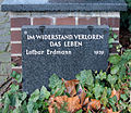
Commemorative plaque for Lothar Erdmann in the Tempelhof park cemetery

Memorial plaque to Eugen Schmohl, builder of the Ullsteinhaus

Memorial plaque Church of St. Fidelis in the St. Matthias Cemetery

Commemorative plaque for bronze statue in the St. Matthias Cemetery
_Berliner_Kapitulation.JPG)
_Columbiahaus.jpg)
_KZ_Columbia.jpg)

_Lothar_Erdmann.jpg)
_Eugen_G._Schmohl.JPG)
_Kirche_St_Fidelius.jpg)
_Bronzesttue.jpg)
-
Berlin memorial plaques
- Former synagogue Neu-Tempelhof, Mussehlstraße 22
- Elisabeth Abegg , Tempelhofer Damm 56
- Fritz Bräuning , Manfred-von-Richthofen-Strasse 77
- Lothar Erdmann , Adolf-Scheidt-Platz 3

Berlin memorial plaque for the former Neu-Tempelhof synagogue

Berlin memorial plaque for Elisabeth Abegg

Berlin memorial plaque for Fritz Bräuning

Berlin memorial plaque for Lothar Erdmann
_Synagoge_Neutempelhof.JPG)


-
Memorial stones
- Memorial stone for the murdered Hatun Sürücü , at the corner of Oberlandstrasse and Oberlandgarten
- Memorial stone for 47 Berlin and Brandenburg victims of the tsunami of December 26, 2004 in the Indian Ocean, old village church

Memorial stone for Hatun Sürücü who was murdered on February 7, 2005

Memorial stone for Berlin and Brandenburg victims of the 2004 tsunami


-
Stumbling blocks in Tempelhof (selection)
- Else Ansbach, Peter-Strasser-Weg 22
- Oskar Ansbach, Peter-Strasser-Weg 22
- Marianne Cohn , Wulfila-Ufer 52
- Franz Klühs , Kleineweg 77
- Herbert Reinert, Friedrich-Karl-Strasse 5
- Elisabeth Schumacher , Werner-Voss-Damm 42
- Kurt Schumacher , Werner-Voss-Damm 42
- Gerhard Wartenberg , Alt-Tempelhof 9

Else Ansbach
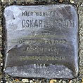
Oskar Ansbach

Herbert Reinert
_Else_Ansbach.jpg)
_Oskar_Ansbach.jpg)
_Marianne_Cohn.jpg)
_Franz_Kl%C3%BChs.jpg)
_Herbert_Reinert.jpg)
_Gerhard_Wartenberg.jpg)
_Elisabeth_Schumacher.jpg)
_Kurt_Schumacher.jpg)
schools
- Askanisches Gymnasium
- Free school in the Ufa factory (elementary school)
- Elementary school on Tempelhofer Feld
- Hugo Gaudig School (Integrated Secondary School)
- Johanna Eck School (Integrated Secondary School)
- Luise Henriette High School
- Maria Montessori Primary School
- Marianne Cohn School (special focus "Intellectual Development")
- Paul Klee Primary School
- Paul Simmel Primary School
- School at Berlinickeplatz (Integrated Secondary School)
- Templars Primary School
Statistical data
All data mentioned here refer to the old Tempelhof district .
Population development
Around 1800
| Tempelhof: | 241 inhabitants |
| Mariendorf : | 162 inhabitants |
| Marienfelde : | 148 inhabitants |
| Lichtenrade : | 112 inhabitants |
Around 1900
| Tempelhof: | 9991 inhabitants |
| Mariendorf: | 5764 inhabitants |
| Marienfelde: | 1946 inhabitants |
| Lichtenrade: | 818 inhabitants |
In 1999
All districts together have around 191,000 inhabitants.
Population level
| Tempelhof-Schöneberg: | 333,110 inhabitants |
| Share of total Berlin: | 9.7% |
| Of which foreigners: | 15.67% (absolute: 52,203) |
(Source: Statistical Yearbook 2009)
Age structure
| Under 6 years: | 8,392 people |
| 6 to under 18 years: | 19,667 people |
| 18 to under 65 years: | 117,637 people |
| 65 years and older: | 39,469 people |
(Status: end of 2005)
Unemployment rate
| Unemployed: | 28,810 inhabitants |
| Of which women: | 13,015 inhabitants |
| Unemployment rate (all civil EP): | 17% |
(As of January 2005)
Personalities
- (in alphabetical order)
- Berta Drews (* 1901 in the Prussian rural community Tempelhof; † 1987), theater and film actress
- Rolf Eden (* 1930 in the old Tempelhof district ), businessman and former night club owner
- Marta Hillers (1911–2001), journalist, lived in an apartment at Manfred-von-Richthofen-Straße 13 (then number 31) until the end of the war. She recorded her experiences during the capture of the city and the subsequent occupation of the Red Army soldiers in the first months afterwards in diary entries, which were published under the title Eine Frau in Berlin and later also with Nina Hoss in the leading role under the title Anonyma - Eine Woman were filmed in Berlin .
- Manfred Kiedorf (1936–2015), set designer, illustrator and miniaturist
- Adolf Lewissohn (1852–1927), real estate and finance broker, founder of the Mariendorf seaside resort
- Rainer Malkowski (* 1939 in the old Tempelhof district; † 2003), poet
- Manny Marc (* 1980), DJ and rapper
- Horst Milde (* 1938 in the old Tempelhof district), founder of the Berlin Marathon
- Michael Müller (* 1964 in the old Tempelhof district), SPD politician, from 1989 to 1996 member of the Tempelhof District Assembly (BVV), since 2014 Governing Mayor as successor to Klaus Wowereit
- Norbert Rieder (* 1942), zoologist and politician
- Elisabeth Schumacher (1904–1942), graphic artist and resistance fighter of the Red Orchestra , lived in Werner-Voss-Damm 42
- Kurt Schumacher (1905–1942), sculptor, medalist and resistance fighter of the Red Orchestra, lived in Werner-Voss-Damm 42
- Klaus Wowereit (* 1953 in the old Tempelhof district), SPD politician, 1984–1995 District Councilor of Tempelhof, 2001–2014 Governing Mayor of Berlin
See also
- List of streets and squares in Berlin-Tempelhof
- List of cinemas in Berlin-Tempelhof
- List of cultural monuments in Berlin-Tempelhof
- List of stumbling blocks in Berlin-Tempelhof
literature
- Christian Simon: Tempelhof. Between idyll and metropolis. be.bra, Berlin 2018, ISBN 978-3-8148-0229-9 .
Web links
Individual evidence
- ↑ Information on the soil associations is available online on the website of the State Office for Mining, Geology and Raw Materials of the State of Brandenburg
- ↑ M. Hendl: The climate of the North German lowlands. In: H. Liedtke, J. Marcinek (Ed.): Physical geography of Germany. Gotha 1994, ISBN 3-623-00840-0 .
- ↑ Ulrich Waack: The early power relations in the Berlin area. A new interim balance sheet of the discussion about the “Magdeburg Hypothesis”. In: Yearbook for Brandenburg State History 54. 2005, pp. 7–38.
- ↑ A similar, elevated peripheral location to the village center, protected by a lake, can also be found in Britz
- ↑ A “Komtur in Tempelhof” actually presupposes the possession of an order, but according to historical-scientific criteria this can only be regarded as an indirect indication.
- ↑ Hans Eberhard Mayer: On the Itinerarium peregrinorum. A reply. In: Hans Eberhard Mayer: Crusades and the Latin East. London 1983, p. III 210 f.
- ↑ For this reason, the older discussion as to whether Templo represents a place name and where to look for this place is outdated because it was conducted in ignorance of Mayer's statements (note 6)
- ↑ Ten years earlier, in 1237, Symeon was not yet provost, but pastor of Kölln and, as a documentary witness in the Brandenburg tithe dispute, ensured the first documentary mention of the twin cities on the Spreepass.
- ↑ Especially because of the documentary witnesses Marsilius (Stadtschulze von Berlin), Symeon (Provost von Kölln) and Abbot Siger von Lehnin. However, the Komtur von Lietzen cannot be completely ruled out either, because de Templo means 'of the Templar Order' much more often than 'of Tempelhof'.
- ^ Arnold Böcklin died, aviation pioneer, painter . At: Radio Bayern 2 , January 16, 2014
- ^ Arnold Böcklin - The dream of death (film text). In: NZZ format
- ^ Landesdenkmalamt Berlin: Monuments in Berlin-Tempelhof, Mariendorf, Marienfelde and Lichtenrade. Michael Imhoff Verlag 2007, pp. 33 and 34.
- ^ Landesdenkmalamt Berlin: Monuments in Berlin-Tempelhof, Mariendorf, Marienfelde and Lichtenrade. Michael Imhoff Verlag 2007, p. 43.
- ^ Landesdenkmalamt Berlin: Monuments in Berlin-Tempelhof, Mariendorf, Marienfelde and Lichtenrade. Michael Imhoff Verlag 2007, p. 34.
- ^ Landesdenkmalamt Berlin: Monuments in Berlin-Tempelhof, Mariendorf, Marienfelde and Lichtenrade. Michael Imhoff Verlag 2007, p. 39
- ↑ Tempelhof . In: Berliner Adreßbuch , 1921, V., p. 418 (The population figures are always included in the official information on the suburb.).
- ↑ The tram network in West Berlin (1945–1967)
- ↑ berlinatnight.de ( Memento from February 17, 2010 in the Internet Archive )
- ↑ schnabeline: The life and times of Marta Dietschy-Hillers - Part 4: The characters and places in "A Woman in Berlin". Clarissa Schnabel, November 7, 2014, accessed August 10, 2016 .
- ↑ Klaus Wowereit / wegewerk GmbH (agency): Klaus Wowereit - Biography. In: klaus-wowereit.de. Retrieved September 4, 2008 . Here is a quote: "I was born on October 1st, 1953 in the Tempelhof district."

.jpg&filetimestamp=20070905112056)