Berlin-Südende
A former villa colony in today's Berlin district of Steglitz in the Steglitz-Zehlendorf district is called the southern end .
location
The extension from the south end is almost exactly 1400 meters in north-south direction and one kilometer in west-east direction. The lowest point is 47.9 meters, the highest 64.9 meters above sea level .
The historical borders of the south end form today's Sommerbad am Insulaner in the north , in the west an almost straight line, which initially runs between Oehlertring and Munsterdamm , between the properties Hanstedter Weg 4 and 6, and Steglitzer Damm 69 and 71, through Borstellstraße , Benzmannstraße and Crossing Stephanstraße to the Brandenburgische Straße 12 property . From here, the respective extension of the middle of the Schünemannweg in both directions forms the southern boundary of the southern end until it meets the Maulbronn bank in an easterly direction at the height of Rottweiler Straße . The eastern border finally forms the route of the Dresden Railway .
Territory affiliation
South end part was originally the district Mariendorf ( Teltow ) south of the former city of Schöneberg . With the formation of Greater Berlin in 1920, Südende was incorporated into the twelfth Berlin administrative district of Steglitz as an independent district . In 1960 Südende lost its status as a district and since then has been part of the Steglitz district as a locality and since 2001 belongs to the sixth Berlin district of Steglitz-Zehlendorf .
In addition to Südende, there is also Nordend as a locality in Niederschönhausen and Westend as a district in the Charlottenburg-Wilmersdorf district . The east can be found as Ostendstrasse in Oberschöneweide , instead of settlements trade and industry have been settled. (see the comments on Ostend )
history
Today's southern end was originally a wild, sandy-swampy Brandenburg area. Larger bodies of water were the Hambuttenpfuhl and the Kelchpfuhl. The partly hilly area was marked on maps as "The Rough Mountains". There were no buildings. In an east-west direction, the route from Steglitz to Mariendorf ran south past the lakes (today roughly the Steglitzer Damm). In a north-south direction, the Priesterweg ran as a footpath from Schöneberg to Lankwitz, west of the Hambuttenpfuhl. In 1841 the railway line of the Anhalter Bahn was built in a north-south direction between the Hambuttenpfuhl and the Kelchpfuhl. A small railway attendant was established, for example at today's Crailsheimer corner of Lörracher Straße .
To purchase the land, which until 1872 belonged to two Mariendorfer farmers, the Terrain-Gesellschaft Südende was founded on August 26, 1872 as a consortium of banks and railways. The amount of the capital was 800,000 thalers . From 1873 , the villa and country house colony Südende was built here on an area of almost 88 hectares , divided into 427 parcels of various sizes, as a villa suburb in country house style. The name "Südende" was finally determined on June 19, 1873; officially and officially registered in the Prussian state register on August 27, 1873 .
The entire building site was sold to a Mr. Christiani in 1874, who founded a new terrestrial company. In 1878 the responsibility of Terrain-AG for Südende expired due to financial difficulties as a result of the great start-up crisis . The company continued to exist until August 27, 1941, with its headquarters in Berlin and Karlsruhe, and then dissolved.
From 1900, more and more three-story apartment buildings were built. The settlement around Langensteiner Weg was only built in 1930.
During the Second World War , Südende was almost completely destroyed by air raids by the Allies , mainly within a few hours during the so-called Lankwitz bombing night from 23 to 24 August 1943 by a British bomber unit. Only much later the Kriegstage- and logs was the after the release of the Royal Air Force in London revealed the exact cause: the bombers had after heavy flak lost the exact orientation and two hours nearly 2000 tons of bombs that actually the government district in the Wilhelmstrasse in Berlin-Mitte should hit, dropped over Südende and the adjacent Lankwitz.
After the war, most of the former houses were only rubble in the entire part west of the Anhalter Bahn, but also in the central area east of the railway ( Ellwangerstrasse and Hünefeldstrasse and the side streets). In contrast, the settlement around Langensteiner Weg and the south-eastern area from Attilastraße to Teltow Canal suffered only comparatively little damage.
At the end of the 1950s, when many other parts of West Berlin had already been rebuilt, comparatively little had happened in Südende; There were still numerous rubble plots, others had been cleared, only here and there a new house was built. As recently as 1957, the Berliner Morgenpost referred to Südende as a "barren field of rubble".
It was not until the 1960s that large parts of the south end were rebuilt. In order to be able to build as cheaply as possible and to keep the space free for the green areas, parking spaces and playgrounds that are now required, settlements with three and four-storey blocks of houses in a loosened arrangement emerged far beyond the former property boundaries. Only then was the cityscape of Südende permanently changed.
building

The first house in Südende was the Bergschlösschen , built between 1872 and 1873 , a former hunting lodge of Count Douglas, which was located on the slope of a mountain. Today the Oehlertring 33 house stands on this property. In 1892, the aviation pioneer Otto Lilienthal made his first flight attempts in the adjacent sand pit .
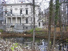
In 1883 there were 17 lots in Südende. They were all in the area of today's Sembritzkistraße and its side streets. The only building among them that survived the Second World War is the late classicist villa at Grabertstrasse 4, built in 1873 by the banker Eduard Mamroth , which served as the home of the Steglitz-Zehlendorf Music School from 1963 to 2005 and has been in service again since July 2008. Today this is not only the oldest building in Südende, but also one of the few surviving examples of the original villa development.

The only industrial building at the south end is the former Scherk-Haus , a striking red brick building in the acute angle between the two railway lines. Here, at Kelchstrasse 31, the Scherk perfume factory was built in 1926 based on a design by Fritz Höger . The building is now a listed building and is used by the Institute for Pharmacy at the Free University of Berlin .
PaReSü
The PaReSü ( Pa rk Re staurant Sü Dende) was in the period between the two world wars, the second largest tourist restaurant in Berlin with about 2,000 seats, the largest with 18 tracks bowling hall in Europe, two large dance and boardrooms, as well as rowing boats for hire and bathhouse directly on - for Property belonging to the natural pond, the Hambuttenpfuhl .
A villa built in 1878 was bought by the Haase brewery around 1900 and converted into a garden restaurant. Later, the land was taken over by the restaurateur Franz Eschstruth and the development was expanded more and more.
In the Second World War, the PaReSü was largely destroyed. Only one building, the Café Parkquelle on Steglitzer Damm , which was built in the 1930s, was rebuilt in 1946 as a “modern urban café”. It was used until 1997, most recently as a discotheque with a bar. Concepts for further use failed because of the poor structure of the building, which had now decayed. After demolition of the remains of the PaReSü (the west opened there Anhalt line of Steglitz dam north) in 2003, a Lidl -Markt .
Personalities
In Südende lived among other things
- the ocean aviator Günther Freiherr von Hünefeld (1892–1929)
- the revolutionary Rosa Luxemburg (1871-1919)
- the composer Arnold Schönberg (1874–1951)
- the painters George Grosz (1893–1959) and Wassily Kandinsky (1866–1944)
- the theologian and writer Jochen Klepper (1903–1942)
- the resistance fighter Adolf Reichwein (1898–1944)
- the parents of the physicist Manfred von Ardenne (1907–1997)
- the journalist and former UN ambassador Rüdiger von Wechmar (1923–2007)
- the architects Otto Rudolf Salvisberg (1882–1940) and Alfred Grenander (1863–1931)
- the sculptor and architect Paul Rudolf Henning (1886–1986)
- the draftsman Walter Trier (1890–1951)
- the director Manfred Durniok (1934-2003)
- the National Socialists Reinhard Heydrich (1904–1942), Martin Wülfing (1899–1986), Hans Weinreich (1896–1963), Eberhard Wolfgang Möller (1906–1972)
- of the resistance to Stauffenbergstraße attributable Wilhelm Canaris (1887-1945)
- the author and publisher Wilhelm Ruprecht Frieling (* 1952)
- the actors Rolf Zacher (1941–2018) and Anita Kupsch (* 1940)
- as well as currently Jan Josef Liefers (* 1964) and Anna Loos (* 1970)
Population development
In 1876 there were 35 households in Südende. The remote location at the Ice Age ponds (small ponds) could be described as idyllic, so that in 1900 1276 people lived here in 107 houses; around 1912 there were around 3350, by 1920 there were 3690, in 1925 a good 4200, in 1932 around 4500 and in 1933 over 5000 inhabitants lived in Südende. The peak was reached in 1939 with a little over 9,000 inhabitants. In 1945 Südende only had 2000 inhabitants, by 1962 the number of inhabitants rose to 7000. Today about 6500 people live in the Südende area.
traffic

The S-Bahn station Südende on the Anhalter Bahn (S25) has been located in the middle of the town since 1880 , and on the eastern edge of the S-Bahn station Attilastraße (1895–1992: Mariendorf station ) on the Dresdener Bahn (S2).
The tram line from Steglitz to the Südende S-Bahn station was set up in 1895, extended to Mariendorf in 1913, replaced by trolleybuses in 1942 and has been operated with omnibuses since 1961 (today: line 282). From 1902, another tram line ran through Südende, running between Tempelhof and Lankwitz via today's Steglitzer Damm and today's Crailsheimer Straße, with three- rail tracks being laid in the Steglitzer Damm area, as both lines had different gauges. After the widening of Attilastraße around 1930, the tram ran in a straight line over it (today: bus route 184).
The south end is crossed by Steglitzer Damm and Attilastraße. The Teltow Canal, on the other hand, runs along the Maulbronn bank just a few meters south of the southern end.
See also
literature
- W. Holtz, C. Simon, U. Wiesmann: Südende - houses, streets, people . Christian Simon Verlag, Berlin 2009, ISBN 978-3-936242-13-3 .
- Christian Simon: Südende - a historical overview . Ed .: Gabriele Schuster, Heimatverein Steglitz.
Web links
Individual evidence
- ↑ Holtz u. a., p. 11
- ↑ Priest path . In: Street name lexicon of the Luisenstädtischer Bildungsverein (near Kaupert )
- ↑ Holtz u. a., p. 15
- ↑ a b Local history of the south end . Heimatverein Steglitz, accessed on May 2, 2019.
- ↑ Holtz u. a., p. 97
- ↑ Holtz u. a., p. 106 f.
- ↑ Holtz u. a., p. 106 ff.
- ^ Berliner Morgenpost , September 8, 1957, supplement; quoted from Holtz u. a., p. 111
- ↑ Holtz u. a., p. 111
- ↑ Holtz u. a., p. 21
- ↑ Holtz u. a., p. 26
- ↑ Entry in the Berlin State Monument List
- ↑ a b Eva Börsch-Supan, Helmut Börsch-Supan, Günther Kühne, Hella Reelfs: Art Guide Berlin . 4th edition. Philipp Reclam jun., Stuttgart 1991, ISBN 3-15-010366-5 , pp. 255 .
- ↑ Holtz u. a., p. 57
Coordinates: 52 ° 27 ' N , 13 ° 21' E
