
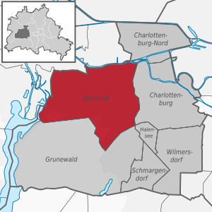
Berlin-Westend
|
Westend district of Berlin |
|
|---|---|
  |
|
| Coordinates | 52 ° 31 ′ 0 ″ N , 13 ° 17 ′ 0 ″ E |
| surface | 13.53 km² |
| Residents | 41,882 (Dec. 31, 2019) |
| Population density | 3095 inhabitants / km² |
| Postcodes | 14050, 14052, 14053, 14055, 14057, 14059 |
| District number | 0405 |
| Administrative district | Charlottenburg-Wilmersdorf |
Westend is a Berlin district in the Charlottenburg-Wilmersdorf district , which is located west of the Charlottenburg district. Originally planned as a pure villa colony and named after the elegant London district , some parts of Westend today have an urban feel with the typical Berlin apartment buildings.
The center and shopping mile of Westend is Reichsstraße between Theodor-Heuss-Platz and Steubenplatz in Neu-Westend . In terms of urban planning , the many differently structured squares in Westend are striking: Branitzer Platz and Anneliese-und-Georg-Groscurth-Platz in the Westend villa colony , Brixplatz with Brixpark, Fürstenplatz and Karolingerplatz on the other side of Heerstraße .
geography


Westend is mostly located on the Teltow plateau , which breaks off steeply to the north towards the Spree . To the north, Westend is bounded by the border with the Spandau district and the Spree, to the east by the Ringbahn , to the south by the AVUS and the Grunewald and to the west by the Stößensee and the Spandauer Vorortbahn .
Locations
With the reorganization of the former district of Charlottenburg by resolution of the district assembly of Charlottenburg-Wilmersdorf on September 30, 2004, some well-known locations belong to the newly formed district.
history
For a long time the sandy, wooded plateau was only built on with a few windmills . After the victory in the battle of Jena and Auerstedt in 1806, Napoleon set up a camp for his occupation troops on the undeveloped eastern slope of Westend, roughly along today's Königin-Elisabeth-Straße. He himself resided in Charlottenburg Palace . The camp with the name Napoleonsburg (or: Napoleonbourg ) was set up on an order of Napoleon in May 1808 by the French governor of Berlin, Victor Duke of Belluno , in June and July and already demolished on November 2, 1808. The front of the roughly right-angled camp ran roughly from Wundtstrasse on Lietzensee in the south to the site of today's DRK clinics Westend near Fürstenbrunn, with the camp about one kilometer wide. It consisted of 380 residential barracks for 20 men each as well as 64 larger barracks for kitchen and dining rooms and two rows of better equipped barracks as accommodation for NCOs.

After the withdrawal of the French troops , Westend fell back into its deep slumber. The forest, which had largely disappeared due to the camp and the deforestation in the area, never seems to have recovered. The painter Heinrich Zille lived around 1900 in Sophie-Charlotten-Strasse across from Westend and documented in numerous photographs the sandy wasteland on the slope to Westend, where Napoleon's camp was almost a hundred years earlier.

In 1840, a Bavarian beer brewer who brewed Bockbier in Spandau acquired the site , which is now in the corner between Spandauer Damm and Reichsstraße, and opened a small bar there, popularly known as the “ Spandauer Bock ” in Berlin . In 1854 he moved his brewery from Spandau to the Spandauer Berg site on the opposite side of the Spandauer Damm, which from then on was called the Spandauer Berg Brewery . The restaurant that was being built there was called " Zibbe " ( northern German for 'mother sheep'). Over time, a lively excursion traffic from Charlottenburg and Berlin developed into the "Spandauer Bock". The two excursion restaurants and the brewery were destroyed in the Second World War and not rebuilt.
The development of Westend in its current form began in the late 1860s. The come to Fortune magazine publisher Ludwig von Schaeffer-Voit was east of the brewery on a slope to the river Spree , the Ruhwald castle built and a large landscaped garden, the present Ruhwaldpark create, around the castle.
Around the same time, Albert Werckmeister (together with Johannes Quistorp , the builder Martin Gropius , the banker Eichhorn and the lottery taker Tuchen) founded in 1866 the limited partnership on shares "Westend" began to buy up large areas in Westend, to parcel them out and to sell them on. Shortly after it was founded, the company ran into difficulties. After its dissolution in 1868, the business was transferred to the Westend-Gesellschaft H. Quistorp & Co. zu Berlin , in which Heinrich Quistorp - brother of Johannes Quistorp, who also built the Westend in Szczecin - and Ferdinand Scheibler were personally liable partners. The waterworks at Teufelssee were built in 1871/1872 to provide water to Westend . Due to the stock market crisis in 1872 and disputes with the city of Charlottenburg, the Westend-Gesellschaft got into financial difficulties and went bankrupt in 1873 .
With the completion of the Ringbahn , Westend station was opened in 1877 . This significantly improved the traffic situation not only for Westend, but also for Charlottenburg. The Charlottenburg train station on the Stadtbahn was only opened in 1882.


After the collapse of the Westend Society, building activity in Westend came to a standstill and some villas were vacant. From the end of the 1870s, the situation eased. Due to the population explosion in the Berlin area, Westend experienced an upswing, so that by the turn of the century the originally parceled area was essentially built on. The barracks of the Queen Elisabeth Guard Grenadier Regiment No. 3 were built on the slope of the Teltow in the 1890s between Soor and Queen Elisabeth Strasse , in 1906 the Epiphany Church to the east based on designs by Jürgen Kröger and the hospital to the north in 1904 Westend (today: DRK clinics Westend ).

In 1908, with the opening of the Reichskanzlerplatz underground station (today: Theodor-Heuss-Platz ) designed by Alfred Grenander , Westend was connected to the Berlin underground . This meant that the southern and western areas of Westend were now also conveniently located, so that Neu-Westend was built on Reichsstraße and to the west of it. The right-angled street layout in the old Westend was replaced by curved lines outside the main axes in keeping with the spirit of the times. Instead of villas like the old Westend, Neu-Westend was mostly built with rental and terraced houses. The trotting track , which opened on Neu-Westender Grund in 1889, was relocated to Ruhleben in 1908 . On the site of a gravel pit from 1919 to 1922 the Charlottenburg city garden director was Erwin Barth of Sachsenplatz (now Brixplatz) built a small deep incised park, geology and vegetation of the Mark Brandenburg replicates.

For the opening of the German Stadium in 1913, the underground line for events was extended to the Stadion underground station (today: Olympia-Stadion). The shell of the Neu-Westend station , which was completed in 1913, was not put into operation until 1922 due to the war , which meant that the underground line was now regularly used. The Spandau suburban railway was built from 1907 to 1911, and today it includes the S-Bahn stations Messe Süd (Eichkamp) , Heerstraße , Olympiastadion and Pichelsberg .
In the 1920s, the extensive facilities of the German Sports Forum were built on the northwestern edge of Westend . The Berlin exhibition grounds were also built at this time in the southeast of the district . At the end of the 1920s, architects of the Bauhaus and New Objectivity, such as Mendelsohn and the brothers Hans and Wassili Luckhardt, built their own, now listed, villas on the Rupenhorn , the high bank above Lake Stößensee. On the occasion of the 1936 Summer Olympics , the Berlin Olympic site and the Germany Hall were built .
Buildings


- The radio tower , built by Heinrich Straumer from 1924 to 1926 on the area of the Berlin exhibition center , is one of Berlin's most famous landmarks with a height of almost 147 meters.
- The International Congress Center Berlin (ICC) was built from 1975 to 1979 by Ralf Schüler and Ursulina Schüler-Witte . The since September 2019 under monument protection standing ICC is currently (as of September 2019) closed due to disrepair. It is still open when a renovation can begin.
- The Olympic Stadium was built by Werner March from 1934 to 1936 on the occasion of the 1936 Summer Olympics and rebuilt and renovated from 2000 to 2004.
- The Corbusierhaus (Unité d'habitation, type Berlin), Flatowallee 16, was built from 1956 to 1958 according to plans by Le Corbusier . It is the third residential unit after the ones in Marseille and Nantes and represents an independent contribution to Interbau . To the left of the entrance is the representation of the Modulor , the system of proportions developed by Le Corbusier.
- The water towers Charlottenburg-Westend I and II , Akazienallee 33–39, were built in 1881 according to plans by Bernhard August Salbach and in 1909 according to designs by Heinrich Seeling . Tower II was supplied by the Teufelssee and Jungfernheide waterworks ; its two containers, one above the other, each held 500 m³. Both towers were converted into loft apartments .
- The studio and home of the sculptor Georg Kolbe at Sensburger Allee 25, which was built in 1928/1929 as a strictly cubic brick building according to plans by Ernst Rentsch and expanded in 1932 according to plans by Paul Lindner , now houses the Georg Kolbe Museum .
- The radio house in Masurenallee , built by Hans Poelzig in 1929/1930, was one of the first radio buildings in Europe.
- The Berlin Waldbühne is considered one of the most beautiful open-air stages in Europe. It is located west of the Olympic site and offers space for 22,000 spectators.
- The Scholzplatz transmitter mast is 230 meters high and was built in 1963. It is operated by the RBB for its radio and television programs.
- The Stößenseebrücke 1909, a steel - truss bridge over the Stoessensee and Havelchaussee of a system of cantilevers with attached tow straps and a wingspan of about 50 meters. It goes back to plans by the civil engineer Karl Bernhard .
- Examples of villa development in Westend

Acacia Avenue 18
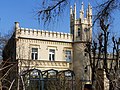
Elmenallee 3

Jasminweg 8
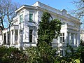
Branitzer Platz 5

Lindenallee 50

Ahornallee 47
.jpg)
.JPG)
_001.jpg)
.JPG)
.jpg)
.JPG)
Embassies and diplomatic missions
_002.jpg)
- Republic of Armenia
- Burkina Faso
- Republic of Cameroon
- Democratic Republic of Congo
- Republic of Namibia
- United Republic of Tanzania
- Republic of Turkey
- Turkmenistan
- Republic of Tunisia
Sacred buildings
- St. George's Anglican Church
- Catholic Holy Spirit Church
- Evangelical New West End Church
- Evangelical Epiphany Church
- Evangelical Peace Church
- Romanian Orthodox Church of Holy Archangels Mihail and Gavriil
traffic
The Westend transport system is well developed, as the modes of transport are generally important due to the urban location, the large squares and the many sights ( Olympic Stadium , trade fair , etc.). Important main roads and the Berlin city motorway run through the district and connect it with the nearby districts of Berlin.

Subway Line 2 , which was partly opened in 1908 and fully opened in 1913, runs through Westend . Later, in 1928, today's U2 line was extended by a station to Ruhleben . The section that runs through Westend is the last western section of the U2. It connects Westend with Charlottenburg , Schöneberg , Mitte , Prenzlauer Berg and Pankow . There is also an operating workshop for the Berlin subway in the district .
In terms of rail technology, Westend is also well connected to the Berlin urban area and the surrounding area by S-Bahn . The Ringbahn (S-Bahn lines S41, S42 and S46) touches the district to the east with the stations Messe Nord / ICC and Westend . The S46 line ends in Westend and continues on the southern ring, then via Schöneweide to Königs Wusterhausen . The S5 line is also of great importance. She comes from Spandau and stops in Westend at the train stations Pichelsberg , Olympiastadion , Heerstraße and Messe Süd . Then it continues through Charlottenburg on the city railway line through Tiergarten and Mitte, then through the eastern districts of Berlin to Strausberg in the Berlin area.
Westend is also connected by numerous bus routes: Metro buses : M45 and M49, express buses : X34 and X49, normal bus routes : 104, 130, 131, 139, 218 and 349, night bus routes: N2 and N42
Parks and nature reserves

The park at Brixplatz was designed from a former gravel pit according to plans by Erwin Barth from 1919 to 1922, whereby the natural vegetation and geological formations of the Mark Brandenburg are reproduced. A citizens' initiative has taken over the maintenance of the botanical teaching garden and has thus so far secured the preservation of this garden monument .
On the western edge of the district are two nature reserves , each with specific biotopes . The flow meadow Ruhleben , which is also designated as a protected area of the European Fauna-Flora-Habitat Directive and as part of the transnational protected area system Natura 2000 , represents a silting bog. The former lake is characterized by a population of rare aquatic plants , a black alder biotope and a wealth of amphibians , among them especially the strictly protected crested newt . It belongs to the compression / terminal moraine landscape Murellenberge, Murellenschlucht and Schanzenwald , which form part of the Teltownordband. In particular, the dry grass areas of the Murellenschlucht have a diverse and endangered flora and fauna . The memorial path ( memorial to commemorate those murdered by the Nazi military justice on Murellenberg ) through the gorge and on the hills reminds with the installation of 104 traffic mirrors of the executions of deserters and so-called " military force disruptors " in the last months of the Second World War at this point .
education
Westend has several high schools. The Herder-Oberschule in Westendallee, the Heinz-Berggruen-Gymnasium (formerly: Erich-Hoepner-Gymnasium and previously Charlottenburger Gymnasium ) in Bayernallee and the Wald-Oberschule in Waldschulallee form the so-called "triangle". The three grammar schools have different focuses: The Herder-Oberschule has a mathematical and scientific orientation and is a member of the MINT-EC . The Heinz-Berggruen-Gymnasium focuses on music and art, while the Wald-Oberschule focuses on sports and languages. The Catholic School Liebfrauen , founded in 1926, is based here.
The Touro College Berlin , part of the Jewish-American Touro university network , has been located at Rupenhorn 5 since 2003 .
The Schele School is a state-approved, privately owned primary school .
Personalities
- Conrad Ansorge (pianist and composer) lived at Nussbaumallee 27
- Elly Beinhorn (pilot) and Bernd Rosemeyer (racing driver) lived at Bayernallee 10/11
- Ernest Beutler (doctor and persecuted by National Socialism) lived at Theodor-Heuss-Platz 2
- Karl Bonhoeffer (psychiatrist and neurologist as well as director of the Clinic for Mental and Nervous Diseases of the Charité in Berlin) lived with his sons Dietrich and Klaus Marienburger Allee 43
- Cato Bontjes van Beek (resistance fighter against National Socialism) lived at Kaiserdamm 22
- Felix Borchardt (landscape and portrait painter) lived around 1914 at Kaiserdamm 39 (today: corner of Heerstraße / Theodor-Heuss-Platz)
- Alfred Braun (radio pioneer) lived at Kastanienallee 34 and Preußenallee 36
- Lil Dagover (actress) lived at Arysallee 4
- Marlene Dietrich (actress and singer) lived at Akazienallee 48
- Günter von Drenkmann (President of the Berlin Court of Appeal) lived in Bayernallee 10/11
- Heli Finkenzeller (actress) lived in Rauschener Allee 5
- Dietrich Fischer-Dieskau lived in Lindenallee
- Wilhelm Foerster (astronomer) lived with his son Karl Foerster (perennial gardener) 1904–1911 at Ahornallee 32
- Willi Forst (actor and director) lived at Sachsenplatz 12
- Willy Fritsch (actor and singer) lived in Kaiserdamm 95
- Gustav Fröhlich (actor) lived at Kurländer Allee 1
- Stefan George (writer) lived in Ebereschenallee 3 and Ahornallee 31
- Erich (architect and resistance fighter against National Socialism) and Elisabeth Charlotte Gloeden (lawyer and resistance fighter) lived at Kastanienallee 23
- Henriette Gottlieb married Henriette Huth (opera singer and victim of National Socialism) lived in Kaiserdamm 84
- Brigitte Grothum (actress) lived in Halmstrasse 10
- Karl-Theodor zu Guttenberg (former Federal Minister)
- Wolfgang Gruner (cabaret artist and actor) lived at Westendallee 57
- Dieter Hallervorden (cabaret artist and actor)
- Edith Hancke (actress) lived in Eichenallee 6
- Veit Harlan (director and actor) and Hilde Körber (actress) lived at Sachsenplatz 1 (today: Brixplatz 2)
- Lilian Harvey (actress, singer and dancer) lived at Düsseldorfer Straße 47
- Theodor Haubach (journalist, politician (SPD) and resistance fighter against National Socialism) lived at Falterweg 11
- Johannes Heesters (actor and singer) lived at Akazienallee 12
- Trude Hesterberg (film actress, cabaret artist and singer) lived in Platanenallee
- Paul Hindemith (composer) lived 1928–1938 at Sachsenplatz 1 (today: Brixplatz 2)
- Otto and Hedwig Hintze (historians) lived at Kastanienallee 28 from 1933–1939 / 1940
- Paul Oskar Höcker (writer) lived from 1908–1929 at Lindenallee 21 and then at Nussbaumallee 8
- Curd Jürgens (actor) grew up in Oldenburgallee 57
- Hildegard Knef (actress, chanson singer and author) lived in Oldenburgallee
- Robert Koch (discoverer of the tuberculosis bacillus) lived in Ahornallee 39
- Georg Kolbe (sculptor) lived in Sensburger Allee 25
- Gertrud Kolmar (writer) lived in Ahornallee 37
- Kate Kühl (cabaret artist) lived in Altenburger Allee 19 until her death in 1970
- Richard Kuenzer (lawyer and diplomat as well as resistance fighter against National Socialism) lived at Ulmenallee 29
- Elisabeth Kuznitzky (resistance fighter against National Socialism), lived at Kastanienallee 23
- La Jana (dancer and actress) lived at Bayernallee 15
- Lotte Lenya (actress and singer) lived at Bayernallee 14
- Sabine and Reinhold Lepsius (artist couple) lived in Ahornallee 30/31
- Theo Mackeben (composer) lived in Marathonallee 15
- Julius Magnus (lawyer and judiciary as well as a victim of National Socialism) lived at Meerscheidtstrasse 13
- Hildegard Margis (women's rights activist, author and resistance fighter against National Socialism) lived at Lyckallee 28
- Pali Meller (architect and victim of National Socialism) lived in Knobelsdorffstrasse 110
- Erich Mendelsohn (architect) lived at Kastanienallee 32 (Pension Müller) from 1922–1930 and Am Rupenhorn 6 from 1930–1933
- Erwin Milzkott (musician) lived in Eschenallee 14
- Brigitte Mira (folk actress, cabaret artist and chanson singer) lived at Akazienallee 46
- Emil Nolde (painter) lived in Bayernallee 10/11 from 1928–1944
- Heinz Oestergaard (fashion designer) lived in Ebereschenallee 4–6
- Anny Ondra (actress) lived at Sachsenplatz 12
- Lilli Palmer (actress) lived in Hölderlinstrasse 11 from 1917–1932
- Harry Piel (actor and director) lived in Ulmenallee 12
- Henny Porten (actress) lived on Sachsenplatz
- Magda Quandt (from 1931 wife of Joseph Goebbels ) lived at Reichskanzlerplatz 3 from 1929
- Carl Raddatz (film and theater actor) lived in Stallupöner Allee 54
- Erich Maria Remarque (writer) lived in Kaiserdamm 114
- Joachim Ringelnatz (cabaret artist and writer) lived at Sachsenplatz 12 from 1930 to 1934 (today: Brixplatz 11)
- Willi Rose (folk actor) lived at Bolivarallee 17 from 1950–1978
- Heinz Rühmann (actor and director) lived at Karolingerplatz 5
- Erich Salomon (photographer) lived in Hölderlinstrasse 11 from 1912–1932
- Thilo Sarrazin (former Berlin Senator for Finance and book author)
- Hjalmar Schacht (Reichsbank President and Reich Economics Minister) lived in Badenallee 9
- Max Schmeling (boxer) lived at Brixplatz 9 until 1933
- Bubi Scholz (boxer) lived at Am Rupenhorn 9
- Oda Schottmüller (dancer and sculptor as well as an active member of the " Red Orchestra ") lived at Reichsstrasse 106
- Arnold Schönberg (composer) lived in Nussbaumallee 17
- Harro and Libertas Schulze-Boysen ( resistance fighters ) lived in 1939–1942 at Altenburger Allee 19
- Annemarie Schwarzenbach (Swiss writer and journalist) lived from 1931–1933 on Königin-Elisabeth-Straße
- Georg Simmel (sociologist and philosopher) lived in Nussbaumallee 14 and Königin-Elisabeth-Straße
- Albert Speer (architect and war criminal) lived in Lindenallee 18
- Camilla Spira (actress and persecuted by National Socialism) lived in Kaiserdamm 118
- Ilse Stöbe and her partner Carl Helfrich (resistance fighter) lived at Ahornallee 48
- Richard Strauss (composer, conductor) lived 1913–1917 at Reichskanzlerplatz 2 (today: Theodor-Heuss-Platz)
- Olga Chekhova (actress) lived in Kaiserdamm 74
- Ernst Udet ( Colonel General and General Aircraft Master of the Wehrmacht ) lived in Stallupöner Allee 11
- Else Ury (writer and victim of National Socialism) lived in Kaiserdamm 24
- Robert Walser (writer) lived in Spandauer Berg 1 from 1910 to 1912
- Wilhelm Wandschneider (sculptor) lived from 1916–1925 at Tannenbergallee 6 (today's Friedenskirche)
- Kurt Weill (composer) lived at Bayernallee 14 from 1928–1932
- Friedrich Weißler (lawyer and resistance fighter against National Socialism) lived in Meiningenallee 7
- Ulrich von Wilamowitz-Moellendorff (classical philologist) lived at Eichenallee 12 from 1897–1931
- Gustav Wunderwald (painter) lived in Reichsstrasse 8 from 1912 to 1945
See also
- List of streets and squares in Berlin-Westend
- List of cinemas in Berlin-Westend
- List of cultural monuments in Berlin-Westend
- List of stumbling blocks in Berlin-Westend
- Berlin-Nordend
- Berlin-Südende
literature
- Stephan Brandt: Berlin-Westend. Sutton, Erfurt 2009, ISBN 978-3-86680-458-6 .
- Harry Balkow-Gölitzer, Bettina Biedermann, Rüdiger Reitmeier, Jörg Riedel: celebrities in Berlin-Westend. be.bra, Berlin 2007, ISBN 978-3-8148-0158-2 .
- Helmut Börsch-Supan (text), Michael Haddenhorst (photos): Westend. Nicolai, Berlin 1997, ISBN 3-87584-664-8 .
- Annemarie Weber (text), Nikolas von Safft (photos): Westend. Edition of the Divan, Berlin 1986, ISBN 3-925683-01-1 .
- Willy Bark: Chronicle of Alt-Westend. Mittler, Berlin 1937. Writings of the Association for the History of Berlin, Issue 56. Digitized by the Central and State Library Berlin, 2012. URN urn: nbn: de: kobv: 109-opus-140360 . Altered reprint Edition of the Divan, Berlin 1986, ISBN 3-925683-00-3 .
Web links
Individual evidence
- ↑ Printed matter 551/02 of the District Assembly of Charlottenburg-Wilmersdorf. Archived from the original on May 20, 2006 ; accessed on June 13, 2008 : "The demarcation should run here in the south along the border with the old district of Wilmersdorf , in the west and north along the border with Spandau and the Spree , in the east along the city motorway and the ring railway ."
- ↑ Printed matter 551/02 of the District Assembly of Charlottenburg-Wilmersdorf. Archived from the original on May 20, 2006 ; accessed on June 13, 2008 : “Within this area are the districts of Pichelsberg , Ruhleben , Eichkamp and Heerstraße , plus the exhibition grounds and the sports forum area around the Olympic Stadium . In detail, these districts seem too small to name them separately. "
- ↑ Bark 1937, p. 23 ff.
- ↑ Sights: ICC - International Congress Center. berlin.de, accessed on January 7, 2016 .