Heerstrasse (Berlin)
|
|
|
|---|---|
| Street in Berlin | |
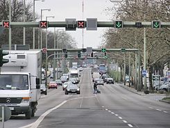
| Beginning of Heerstrasse at Theodor-Heuss-Platz | |
| Basic data | |
| place | Berlin |
| District | Westend , Wilhelmstadt , Staaken |
| Created | 1874 |
| Hist. Names | Döberitzer Heerstrasse |
| Connecting roads |
Kaiserdamm , Hamburger Chaussee |
| Cross streets | (Selection) Jafféstrasse, Preußenallee, Teufelsseestrasse, Flatowallee , Am Postfenn, Pichelsdorfer Strasse, Gatower Strasse, Wilhelmstrasse , Magistratsweg, Nennhauser Damm |
| Places |
Theodor-Heuss-Platz , Scholzplatz |
| Buildings | British war cemetery |
| use | |
| User groups | Pedestrian traffic , bicycle traffic , car traffic , public transport |
| Technical specifications | |
| Street length | 10,640 meters |
The highway runs to the west of Berlin by Theodor-Heuss-Platz to the western city limit in Spandau district Staaken . It is part of federal highway 5 along its entire length ; from Theodor-Heuss-Platz to Wilhelmstrasse , it is also Bundesstrasse 2 . With a length of over ten kilometers, it is one of the longest streets in Berlin and an important entry and exit road .
history
Planning and construction
The road was laid out in 1874 as a road from Charlottenburg to Pichelsberg . It served as a parade route to the Döberitz military training area, where the parades of the guard regiments were held in place of the previous training area on Tempelhofer Feld . In 1911 it was ceremoniously opened to traffic as Döberitzer Heerstraße in the presence of Kaiser Wilhelm II . It had been expanded in sections since 1903. This was related to the expansion of a wide representative street, which began at the Berlin Palace and so far bent at the knee from Unter den Linden and led to Charlottenburg Palace . Now the straight extension took place over Bismarckstrasse and Kaiserdamm with a slight turn at what later became Scholzplatz. From 1920 the name was shortened to Heerstraße .
Current condition
Trams operated on Heerstrasse until January 24, 1966 . The former tram route is now preserved as a green strip on the northern side of Heerstrasse between Theodor-Heuss-Platz and Stößenseebrücke . In this area there is also a somewhat narrower green strip on the southern side. On the other side of both strips there is a two-lane parallel street, which is mainly used for parking residents and cyclists. The Heerstraße itself is shown here as a five-lane motor road. From the Stößenseebrücke there is a cycle path on both sides . From Pichelsdorfer Straße, Heerstraße has four lanes, with a two-lane parallel street on both sides for parking and local traffic.
Between Theodor-Heuss-Platz and Pichelsdorfer Straße there is a traffic light and traffic control system that directs the flow of traffic by displaying the optimal driving speed and enables a “ green wave ”. This system can also be used to open or block the middle lane of Heerstraße if necessary (for example to direct rush hour traffic or event traffic to the Olympic Stadium or the Waldbühne ).
Manor district of Heerstraße (1914–1920)
Heerstraße gave its name to the estate district of Heerstraße, which was newly formed in 1914 in the district of Teltow from the northern part of the already existing estate district of Grunewald-Forst . The estate district of Heerstraße comprised the residential areas on both sides of Heerstraße between the Stößenseebrücke and the Heerstraße train station, as well as today's Olympic site and Ruhleben . In 1920 it was incorporated into the newly created Greater Berlin with its then 773 inhabitants and was absorbed into the former districts of Charlottenburg and Spandau .
course
Theodor-Heuss-Platz to Heerstraße S-Bahn station
Heerstraße begins at Theodor-Heuss-Platz in the Westend district of the Charlottenburg-Wilmersdorf district , in the immediate vicinity of which the Messe Berlin GmbH exhibition grounds with the radio tower , the broadcasting house and the International Congress Center (ICC) as well as the central bus and coach Train station (ZOB) are located.
In an east-west direction, it runs through densely built-up areas to the Heerstraße S-Bahn station , where it crosses the Spandau suburban railway . Until March 30, 1950, this part of Heerstrasse was still called Kaiserdamm . On the north side is the listed office building Heerstraße 12-16 , which was built between 1938 and 1941 for the Reich Youth Leadership of the Hitler Youth . Behind the train station, the Teufelsseestrasse branches off to the left, which is later called Teufelsseechaussee and leads to the Teufelssee and to the Teufelsberg , the highest mountain in Berlin, made of rubble from the Second World War .
S-Bahn station Heerstraße to Scholzplatz

Then it runs through loose development south of the " Georg-Kolbe-Grove " and the Olympic Stadium and then passes the former houses of the British Armed Forces in Berlin. The area belonged to the British Sector during the Occupation Statute until German reunification . The Grunewald , which extends to Wannsee , begins south of Heerstraße, and numerous pine trees next to the road show the proximity to the forest .
In 1992, at Glockenturmstrasse 18, one of the largest underground natural gas storage facilities in Europe with a capacity of six million cubic meters was put into operation at a depth of 800 meters . The capacity is sufficient to supply Berlin households for about a year. Nearby is the Waldbühne , a venue for 22,000 spectators.
Scholzplatz to Pichelsdorfer Straße
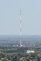
In the local area of Pichelsberg, Heerstraße at Scholzplatz bends slightly to the right in a west-northwest direction when looking out of town. The Belvedere high-rise estate is on the right-hand side on Angerburger Allee. On the left there are the British military cemetery ( Berlin War Cemetery ) and the Jewish cemetery highway on which, among others, Hans Rosenthal and Heinz Galinski are buried. Behind the cemetery stands the approximately 230 meter high Scholzplatz broadcasting mast of the RBB . Further to the west, the Heerstraße crosses the Stößenseebrücke , under which the Havelchaussee and a branch of the Stößensee run. There is Spandau district in the district Wilhelmstadt reached and located at the 800 meters behind Frey bridge which - channeled in this area - Havel crossed. In the local area of Pichelsdorf there is a changing picture between loose and narrow development as well as the landscape-protected Grimnitzsee and the grounds of the south park.
Pichelsdorfer Straße to the city limits
The Pichelsdorfer Straße , which branches off to the right, forms the connection to the old town of Spandau .
Behind Gatower Straße , which is also an important traffic junction for various bus routes , which u. a. to the City West drive is to the right of the bus depot Spandau the BVG .
To the underlying Wilhelmstrasse leading national road 2 to the left in southwestern direction and forms since the fall of the wall again an important compound according to Potsdam . Federal highway 5, which runs parallel up to this point , continues on Heerstrasse. At the next - to the west - crossing with the sand road you will reach Staaken . In the following course, Heerstraße crosses some new building areas with - especially in the area of the large Heerstraße Nord estate - different eaves heights of the houses, such as those in Blasewitzer Ring and Obstallee .
At the height of Reimerweg, the view opens up to the south to a heaped mountain called Hahneberg , also known as "Neuer Hahneberg". This part was a rubble dump in the early 1970s and after being greened it is now a park. The heaped mountain has the name Hahneberg from the original Hahneberg (directly to the west), which was in the border area of the GDR until the fall of the wall . Fort Hahneberg is also located on this .
Shortly before the Berlin city limits, near the confluence of Nennhauser Damm, Heerstraße cuts through the low-rise housing estate " New Jerusalem " (built in 1923/1924 by Erwin Anton Gutkind in the New Building style ).
Further course
Heerstraße continues as Bundesstraße 5 under the name Hamburger Chaussee in Brandenburg . It leads into the Havelland , crosses the Berlin motorway ring and runs via Hamburg to the Danish border.
Before the construction of the Autobahn 24 (Berlin – Hamburg), this route was of great importance for the connection on this transit route , as it was the only transit route in the form of a country road. As a result, it could also be used by cyclists between West Berlin and what was then federal territory . Today Heerstraße is one of many inward and outward streets that connect downtown Berlin with the western districts and the Brandenburg area, including the Havelpark shopping center in Dallgow-Döberitz and the Factory Outlet Center in Elstal as well as the A 10 ( Junction 26 - Berlin-Spandau ).
Others
There was a special feature in the westernmost part of Heerstrasse. The part of Spandau that runs up to Bergstrasse belongs to the Staaken district , which until then belonged to West Berlin after the city was divided. The section of the street in Staaken (" West-Staaken ") that continues to the west of the city limits belonged to the independent GDR community of Staaken. This area was reintegrated into Spandau after German reunification and now forms the end of the city. This is where the Heerstrasse ends. Due to this structure, the border crossing point for the transit route to Hamburg was in the middle of today's Staaken district.
The reason for this border management was an exchange of interests, in which the western part of Staakens against part of the municipality of Seeburg, which until 1945 reached almost as far as the Havel (in particular the Rieselfelder on the Gatower Heide) and part of the municipality of Groß Glienicke (to round off the Gatow airfield reaching the city limits ) were exchanged. As a result, the British allies secured unhindered access to the airfield they used in their Berlin sector and the Soviet allies secured the Staaken airfield .
literature
- Frey: Döberitzer Heerstrasse . In: Zeitschrift für Bauwesen , volume 61 (1911), columns 69–86, plates 10–11. Digitized in the holdings of the Central and State Library Berlin .
Web links
-
Heerstrasse. In: Street name lexicon of the Luisenstädtischer Bildungsverein (near Kaupert )
- Döberitzer Heerstrasse . In: Luise.
Individual evidence
- ↑ Supplement to the address book for Berlin and its suburbs 1907: Plantrasse der Döberitzer Heerstrasse . Large transport plan for Berlin and its suburbs . Designed and drawn by Alfred Mende in Berlin, geographer-lithographer. Institute
- ↑ For photos of Heerstrasse with trams, see Tram Forum , 6th to 11th picture from above
- ↑ Heerstraße settlement in the district lexicon at berlin.de
- ^ Greater Berlin Act, Annex II
Coordinates: 52 ° 30 ′ 48.2 " N , 13 ° 11 ′ 42.7" E


