
Frey Bridge
Coordinates: 52 ° 30 ′ 42 ″ N , 13 ° 12 ′ 11 ″ E
|
|
||
|---|---|---|
 status: January 2018 |
||
| Official name | Frey Bridge, until 1913: Havel Bridge |
|
| use | Road traffic, pedestrians, cyclists | |
| Convicted | Highway ( Federal Straße 2 / 5 ) | |
| Crossing of | Havel , Havelseenweg of the Tiefwerder meadows | |
| place | Berlin-Wilhelmstadt | |
| construction | Steel arch bridge with a roadway below | |
| overall length | 157.90 m | |
| width | 24.50 m | |
| Longest span | 80 m | |
| Clear height | 5.25 m above sea level BWo | |
| vehicles per day | 60,000 | |
| building-costs | € 33 million | |
| start of building | 2015 | |
| completion | December 2017, opening for traffic: December 20, 2016 | |
| planner | New waterways construction office in Berlin | |
| location | ||
|
||

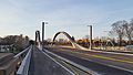
The Freybrücke is an arched bridge in the Wilhelmstadt part of Berlin's Spandau district . They transferred the highway ( Bundesstraße 2 / 5 ) on the Havel and Havelseenweg and connects Pichelsdorf with the peninsula Pichelswerder . The 157.90 meter long structure is used by around 60,000 drivers every day.
The original, 174-meter-long road bridge from 1908/1909 was designed by the civil engineer Karl Bernhard . This old bridge was demolished in 2014 for economic reasons due to considerable damage despite its listed status. The new building of the same name was opened in December 2016.
The structure, which was initially referred to as the Havel Bridge, was named Frey Bridge in 1913 on the decision of the Osthavelland district . The name was given to the “meritorious leader” of the construction of Döberitzer Heerstraße (today's Heerstraße), the secret building advisor Adolf Frey .
Part of the Heerstraße project
Döberitzer Heerstrasse and development of the Pichelswerder
The Frey Bridge was part of the overall Döberitzer Heerstraße project , which was built between 1903 and 1911 as an extension of the Kaiserdamm as a direct connection from the Berlin Palace via the cities of Charlottenburg and Spandau, which were independent until they were incorporated into Greater Berlin in 1920, to the Döberitz military training area. The east-west street consists of today's streets Unter den Linden , Straße des 17. Juni , Bismarckstraße , Kaiserdamm, Heerstraße and after the Berlin city limits the Hamburger Chaussee in Dallgow-Döberitz .

The site of the bridge belonged to the Osthavelland district at the time of construction . While the military, finance and forestry treasury as well as Berlin, Charlottenburg, Spandau, the district of Teltow, the district of Osthavelland and some municipalities were financially involved in the overall project, the financing of the Frey Bridge was largely the responsibility of the forest treasury, which the Berlin monument database states as the builder of the bridge .
The road, built for military reasons, was public from the start and opened up the western Grunewald and Pichelswerder for the wide range of Berlin and Spandau excursion traffic. The Pichelswerder, in particular, has long been a major attraction for Berliners. As early as 1806, Johann Christian Gädicke stated in the Lexicon of Berlin and the surrounding area about the "Pichelsdorfschen Werder, in the Havelländischer Kreis, near Spandau" : "This area is used a lot for pleasure and is considered the most beautiful around Berlin."
Bridging the Havelniederung and costs
Bridging the Havel lowlands on the northwestern foothills of the Teltow plateau was the greatest technical and financial problem in road construction. Among several variants, including an additional 250-meter-long bridge over the Scharfe Lanke (if the Heerstraße continued at Scholzplatz), the planners opted for a slight bend in Heerstraße to the north-west and thus a route that managed with two bridges . The Stoessensee bridge, which is around 800 meters to the east, spans the Stoessensee , an arm of the Havel. A 450-meter-long dam was built in the lake from Pichelswerder, which reduced the length of the Stößenseebrücke to 100 meters. The 174-meter-long Frey Bridge leads over the Havel, which was canalised in this area in 1880/1881, and the Havelseenweg, a foot and cycle path that leads from Pichelswerder between the river and the Tiefwerder meadows to the village of Tiefwerder . While the most expensive option for bridging the Havelniederung with the large bridge over the Scharfe Lanke was estimated at 16.9 million marks , the implemented solution had a comparatively small amount of 2.54 million marks. Of this, the Frey Bridge accounted for 1.14 million marks (adjusted for purchasing power in today's currency: around 6 million euros).

Execution of the old bridge
Bernhard's aesthetic steel construction without architects

Inspired by the Paris road bridges when visiting the World Exhibition in 1900 , Karl Bernhard went over to designing “pleasing iron bridges without architects”, the lines of which should only come about “through the interaction of static and aesthetic aspects”. For the Treskow Bridge in 1903 he developed a truss arch with a drawstring and a suspended central field, which formed the support members of the bridge with iron girders under the side vaults. He also used this system for the Stubenrauch Bridge and the Frey Bridge, while Kaiser Wilhelm II selected a different system ( cantilever with attached towers) from Bernhard's proposals for the neighboring Stößenseebrücke . With the Frey Bridge, Bernhard developed the Treskow Bridge concept further:

"If it is a question of the connection of floor beams above the carriageway of the central opening with carriers lying under the carriageway, there are five openings here, so that two side openings with corresponding carriers adjoin the central main opening on both sides of the floor beams. Because the wide arches of the central opening protrude above the roadway, while the main girders of all four side openings are below the roadway, the entire bridge image is given a characteristic that emphasizes the opening of the river. "
construction
pier
Originally, only the Havel was to be spanned with a 65 meter long bridge and the lateral moor masses were to be displaced by sand pouring . Because of fears that the embankment could stay in motion for a long time and endanger the stability of the piers, the bridge was extended over the banks on both sides until a stable foundation for the embankment and the end piers was reached. In the bank area the thickness of the moor layers was up to eight meters, while at the chosen location of the end pillars they were only around 1.25 to 2 meters thick. This resulted in a stream opening of 63 meters and two land openings of 31.5 and 18.9 meters, making a total of 163.8 meters long bridge.
The bank pillars carry the two main girders of the central opening and, because of their significant distance, consist of two individual pillars. The pillars between the bank and end pillars carry four supports and accordingly consist of four individual pillars. They rest on a cohesive foundation body. Staircases are attached to each of the four end pillars. All pillars are established by air pressure and were executed by Philipp Holzmann & Co., Frankfurt am Main.

Bank pier, 2009
Roadway and the two main girders spanning 63 meters, 2009

View from the Frey Bridge to the Havel and the Tiefwerder Wiesen (right)

Structure in case of demolition


Structure and superstructure
A passage height of four meters had to be kept free for shipping on the Havel during floods , so that the main girders spanning 63 meters could not be arranged under the bridge. The main girders were therefore placed on both sides of the 16 meter wide carriageway, resulting in an unusually large main girder spacing of 17.60 meters for the time. In the side openings, the supporting structure lies under the roadway. The arrangement was made in such a way that later riverside roads could be built. The upper edge of the carriageway was in the middle of the bridge at 37.427 meters above sea level , the lower edge of the building at 35.25 meters above sea level. There was a one-sided gradient of 1: 270 for the bridge, which had to be reinforced to 1:50 from the bank in order to reach the foot of the ramp. Heerstraße does not cross the Havel at a right angle and since the pillars should still be parallel to the bank, the two main girders of the central opening are shifted against each other by 2.48 meters in the longitudinal direction of the bridge. This gave the cantilever arms on the main girders different lengths.
The thrust of the two-hinged arch above the central opening is absorbed by a drawstring that engages at the first node of the lower chord. The arch is 4.35 meters high above the two supports and 1.60 meters in the middle. The arrow height of the lower chord is 10.57 meters. The spans of the openings are: end openings 18.90, side openings 32.74 and 30.26 and central opening 63 meters. The truss arches of the central opening are filled with post trusses , the main girders of the side openings and the cantilever arms with strut trusses.
To prepare the 1,600 tons of heavy superstructure one was crane with 26 m span and 11 meters clear height used. Two electrically operated trolleys, each with a load capacity of twelve tons, lifted and moved the structural parts. The building materials and iron parts were transported on the river to the construction site and driven to the scaffolding on field railcars. The installation took six months and was carried out by the Berlin company Steffens & Nölle.
Destruction in World War II and reconstruction
During the Second World War , the bridge on the southeastern pillar next to the Havel was blown up. As a result, the main span of the bridge collapsed into the Havel, and the two adjacent fringes were also badly damaged. In addition, there was irreparable previous damage to the bridge foundation. It is very likely that the demolition was carried out in 1945 by the German Wehrmacht to prevent the Soviet troops from advancing further into Berlin.
The reconstruction took place between 1948 and 1951, here essential elements of the original construction were largely reused after expansion and refurbishment.
Demolition of the old bridge and temporary bridges


In 2008, considerable corrosion damage was found on the longitudinal and cross members. The bridge was therefore only passable at 30 km / h, vehicles over 3.5 tons total weight had to use the right lane. Since January 13, 2014, the bridge has also been closed to trucks and buses weighing more than 18 tonnes (briefly: 10 tonnes), the latter also affecting articulated and double-deckers on regular services. For economic reasons, the bridge should not be repaired, but replaced by a new one.
The northern, two-lane makeshift bridge has been open to traffic in the direction of Spandau since September 1, 2014; traffic in the direction of the city center initially continued on the old bridge. With this relief of the old construction, the regular service was resumed without restriction. For other gravity traffic towards the city center, there was still a blockage until the opening of the southern temporary bridge on October 13, 2014.
The dismantling of the old bridge began in mid-December 2014. The last phase of the demolition began on March 18, 2015. The bridge was supported with the help of two pontoons and divided into smaller segments on site using two mobile cranes . For this purpose, the Havel was closed to traffic for three days, car traffic was not impaired.
Parts of the bridge railing are to be used on the nearby riverside path in Grimitzpark on the Havel.

Replacement new building
Planning as part of the German Unity transport project
A replacement building had been planned for a long time, regardless of its condition. For example, as part of the German Unity Transport Project No. 17 , two-layer container ships with a passage height of around 5.25 meters above the upper service water level should be enabled. Since the Frey Bridge was not high enough and the shipping opening had to be widened, it should be demolished and renewed along with other bridges. The further implementation of the project had been suspended for some time. The transport project was considered controversial for ecological reasons. Its implementation would, for example, significant impact on the water level dynamics of lying below the bridge Frey Tiefwerder meadows , the last natural flooding and Hecht - spawning area in Berlin. In addition, large parts of the Havel biotope network would be affected. Environmental associations and Bündnis 90 / Die Grünen criticized the expansion plans.
Construction data of the new bridge
On August 9, 2010 the replacement building was approved and the corresponding planning approval decision was published. The new bridge was to be raised by 48 centimeters compared to the previous one, but no widening of the waterway below was planned. Before the old bridge was dismantled, two two-lane and 143-meter-long temporary bridges, type SS80 , were built north of it . The construction time was estimated at three years. The tender for the construction contract was published on January 19, 2012. The construction contract was placed in the 4th quarter of 2012, and preparatory measures have been carried out since the beginning of 2013. The official start of construction was celebrated on May 16, 2013. The construction costs were estimated at around 33 million euros, of which the Federal Highway Administration intended to bear around 16.2 million euros, the State of Berlin around 5.4 million euros and the Federal Road Administration around 11.4 million euros. The new bridge was built as a steel composite structure with a total length of 157.90 meters and a width between the railings of 24.00 meters. The clearance under the bridge has been increased to 5.25 meters in connection with the German Unity Transport Project No. 17.
Assembly and opening
The new bridge was pre-assembled in the southern port of Spandau and, after the old bridge was demolished, it was transported to its destination on the Havel by pontoons . In September 2015, the components for the fore bridge arrived by truck, as delivery by ship was not possible due to the low water. The front bridge was installed on site from October 10, 2015. On April 16, 2016, the arches connected the banks again. On June 3, 2016, the 400- tonne middle section, the so-called Stromfeld, was transported and lifted from the Oberhafen of the Südhafen north of the Schulenburg Bridge to the Frey Bridge. On June 4th, the welding work began to anchor the raised central section of the bridge. The Havel was closed to passage in this section on both days. The opening for traffic was sought for November 1, 2016, but the weather conditions prevented the last asphalt and marking work.

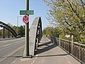
Name stone

Bridge piers

Staircase based on a historical model
roadway


Traffic was opened on December 20, 2016 after a short speech by State Secretary for Transport Kirchner . Initially only four lanes were available, as the northern footpath and bike path could only be installed after the temporary bridges had been dismantled. This work was completed at the end of December 2017. After the temporary bridges have been expanded and their access roads demolished, a second staircase to the Havel towards the city center will be built. In future, pedestrians will be able to cross under the bridge on the east side and thus change sides of the street.


See also
literature
- Karl Bernhard : Stößensee and Havel bridges on the Döberitzer Heerstraße. In: Journal of Construction . 61. Jg. 1911, pp. 322-358. (Digitized version)
- Adolf Frey: Döberitzer Heerstrasse. In: Journal of Construction. 61, 1911, pp. 69-86. (Digitized version)
- Ernst Friedel : Döberitzer Heerstrasse. In: Ernst Friedel (Hrsg.): Large Berlin Calendar, Illustrated Yearbook 1913 . Verlag von Karl Siegismund, Berlin 1913, pp. 291–295.
- Arne Hengsbach: The Berlin Heerstrasse. A chapter in planning history. In: The Bear of Berlin. Berlin 1960, F. 9., pp. 87-112.
- Peter Rode, Michael Günther: Berlin transport locations through the ages. The Pichelswerder and its bridges. In: Verkehrsgeschichtliche Blätter . Volume 38, issue 6, November / December 2011, pp. 157–167.
- Federal Ministry for Transport, Building and Urban Development / Senate Department for Urban Development and the Environment (Ed.): Replacement construction of the Frey Bridge in the course of the Bundesstrasse 2/5 over the Untere Havel waterway. Berlin 2013.
Web links
Individual evidence
- ↑ a b Finally: Cars are rolling over Freybrücke again. In: Der Tagesspiegel. December 21, 2016. (tagesspiegel.de)
- ↑ Berlin police block dilapidated bridge. In: Berliner Morgenpost . 15th January 2014.
- ↑ a b c Entry in the Berlin State Monument List
- ↑ Zentralblatt der Bauverwaltung , 33rd year 1913, No. 9 (from February 1, 1913) (digitized version) , p. 7. (Note on the designation in the "Miscellaneous" section)
- ↑ Various websites, such as those of the Berlin city administration, erroneously state that the bridge was named after the Swiss writer Adolf Frey .
- ^ Ernst Friedel: Döberitzer Heerstrasse . ..., p. 292.
- ^ Adolf Frey: Döberitzer Heerstrasse . ..., p. 71.
- ↑ Quoted from: Arne Hengsbach: Spandau-Hauptstadt. The capital and the Havel city. Berlin and Spandau in their mutual relations. In: Mitteilungen 1, 1987 , Association for the History of Berlin
- ^ Adolf Frey: Döberitzer Heerstrasse . ..., p. 76.
- ^ Karl Bernhard: Stößensee and Havel bridges in the course of the…. P. 323 f.
- ^ Adolf Frey: Döberitzer Heerstraße ..., p. 77.
- ↑ Cengiz Dicleli: Karl Bernhard. "The artistic must completely permeate the technical." (PDF). In: Forum. The research magazine of the Konstanz University of Applied Sciences, edition 2003/2004, pp. 21–24 ISSN 1611-3748 .
- ^ Karl Bernhard: Stößensee and Havel bridges in the course of the…. P. 345 f.
- ^ Karl Bernhard: Stößensee and Havel bridges in the course of the…. P. 346.
- ^ Adolf Frey: Döberitzer Heerstrasse . ..., p. 80.
- ^ Karl Bernhard: Stößensee and Havel bridges in the course of the…. Pp. 345 f, 350.
- ^ Karl Bernhard: Stößensee and Havel bridges in the course of the…. P. 350.
- ^ Karl Bernhard: Stößensee and Havel bridges in the course of the…. P. 345 f.
- ^ Karl Bernhard: Stößensee and Havel bridges in the course of the…. P. 347 f.
- ^ Karl Bernhard: Stößensee and Havel bridges in the course of the…. P. 356.
- ↑ a b Small inquiry: Expansion of the Havel and Spree (II) ... (PDF; 34 kB) Berlin House of Representatives, April 18, 2012, accessed on May 4, 2012 .
- ^ History of Pichelsdorf
- ↑ Frey Bridge closed to trucks. In: Berliner Zeitung . January 14, 2014, accessed January 14, 2014 .
- ↑ a b c Freybrücke in Spandau is being built for 30 million euros. In: Berliner Morgenpost . October 14, 2010, accessed April 20, 2012 .
- ↑ a b Very carefully: The BVG rolls over the Frey Bridge. In: Der Tagesspiegel . September 1, 2014, accessed September 3, 2014 .
- ↑ Replacement building for Frey Bridge is completely accessible from today. In: Der Tagesspiegel . October 13, 2014, accessed October 14, 2014 .
- ↑ The old Frey Bridge is being dismantled . In: Berliner Morgenpost . March 18, 2015.
- ↑ Freybrücke railing gets new honors on the redesigned Havel bank . In Spandauer Volksblatt , week 16/2015
- ↑ Ship ahoy! Because large container ships are to pass through Berlin in the future, five bridges have to be demolished and rebuilt . In: Berliner Zeitung . February 18, 2009.
- ↑ Waterways to and from Berlin. The connection to the west: two-layer container traffic is now possible . ( Memento of May 9, 2008 in the Internet Archive ) IHK online, accessed on April 17, 2009.
- ↑ We don't need a waterway! Alliance 90 / The Greens - Decision of the State Delegates' Conference, October 6, 2007.
- ↑ Replacement of the Frey Bridge approved. (PDF; 24 kB) Federal Waterways and Shipping Administration, August 16, 2010, accessed on April 20, 2012 .
- ↑ Planning approval decision: replacement of the Frey Bridge. (No longer available online.) Federal Waterways and Shipping Administration, archived from the original on February 2, 2014 ; Retrieved April 20, 2012 .
- ↑ Contract announcement: Replacement construction of the Frey Bridge over the Untere Havel-Wasserstraße (UHW) in the course of the federal highway B 2/5 in Berlin-Spandau. Senate Department for Urban Development and the Environment Berlin, January 19, 2012, accessed on April 20, 2012 .
- ^ Symbolic start of construction for the replacement of the Frey Bridge on May 16. Senate Department for Urban Development and the Environment, May 16, 2013, accessed on May 18, 2013 .
- ↑ The construction work on the replacement building is progressing. This included the first steel construction work on the new Frey Bridge. At: berlin.de , accessed on February 23, 2016.
- ↑ Assembly of steel components for the replacement of the Frey Bridge leads to temporary traffic restrictions . At: berlin.de , accessed on February 23, 2016.
- ↑ Freybrücke: Today the banks are connected to one another . In: Der Tagesspiegel . April 16, 2016.
- ↑ The last large steel component for the new Frey Bridge is lifted into place - Senator Geisel informs himself about the construction progress . At: berlin.de
- ↑ The 400-ton block swims over the Havel. In: Der Tagesspiegel . June 1, 2016.
- ↑ The Frey Bridge is released on November 1st . In: Der Tagesspiegel . 5th October 2016.
- ↑ The anger builds up in Spandau - because 25 gullies are broken . In: Der Tagesspiegel . February 23, 2016.
- ↑ Wetness delays clearance of Frey Bridge: Asphalt is still missing. berliner-woche.de, November 12, 2016.
- ↑ The bridge got a damper: Freybrücke has five lanes again. In: Spandauer Volksblatt . 5th January 2018.