
Havelseenweg
| Havelseenweg | |
|---|---|
 Havelseenweg and Havel at the edge of the Tiefwerder meadows |
|
| Data | |
| length | 25 kilometers |
| location | Berlin ( 20 main green routes ) |
| Supervised by |
FOOT e. V. BUND-Berlin Citizens' Project "Network" Berliner Wanderverband Stadtentwicklung |
| Markers |
 Blue field, white "12" |
| Starting point |
Ronnebypromenade / Königstrasse 52 ° 25 ′ 15 ″ N , 13 ° 10 ′ 21.1 ″ E |
| Target point | Havel ferry Aalemannufer 52 ° 34 '22.6 " N , 13 ° 13' 24.4" O |
| Type | trail |
| Height difference | low |
| The highest point | Heerstrasse 42.6 m above sea level NN |
| Lowest point |
Dead coat 30.5 m above sea level NN Hans-Werner-Klünner-Weg |
| Level of difficulty | developed hiking trail, partly forest trail |
| season | all year round |
| Viewpoints |
Large window on the Großer Steinlake ( location ) Grunewald tower ( location ) |
| particularities | The Havelseenweg leads from the Großer Wannsee (east bank) along the banks of the Havel through Spandau to the west bank in Hakenfelde . |
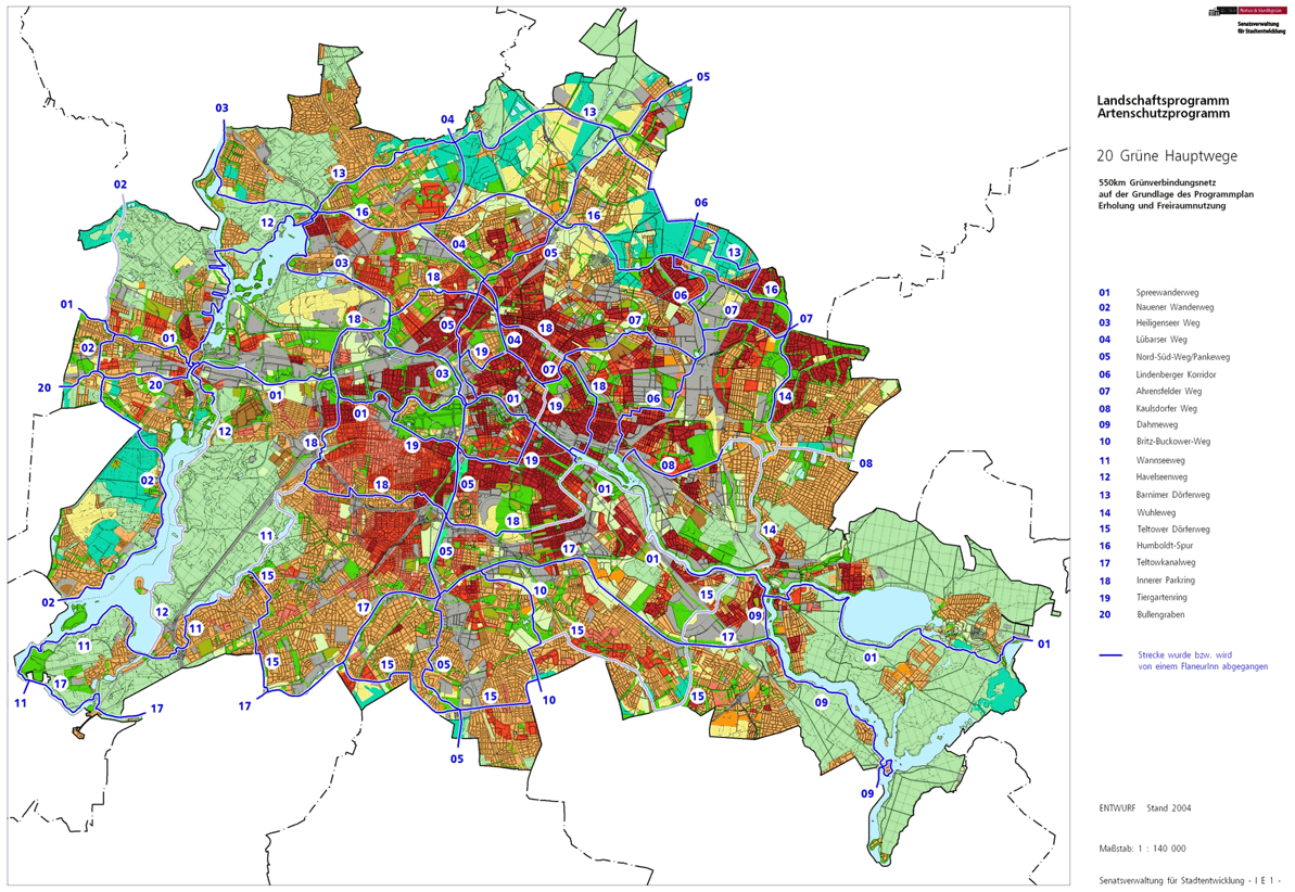
The Havelseenweg , number 12, is one of the 20 main green paths . This is a compilation of 20 hiking trails through the Berlin urban area with a total length of around 550 kilometers. The aim is to link “residential areas with the diverse recreational opportunities in parks and local recreation areas in Berlin and Brandenburg ” (Senate Department for Urban Development and the Environment). The pedestrian should have the opportunity to “experience the city intensely as a combination of culture, history and ecology”.
course
The Havelseenweg runs for 25 kilometers along the Havel and its lakes (i.e. the river widening) and lies between the Großer Wannsee in the Wannsee district ( Steglitz-Zehlendorf district ) in the south and the Aalemannufer in the Spandau district, Hakenfelde district . The determining factor is the proximity to the banks of the Havel waters and the surrounding landscapes, on the one hand the plateau of the Teltow in the south and the plain of the Warsaw- Berlin glacial valley in the north . For the Teltower slope edge, the path through the Grunewald does not run directly on the banks of the Havel, but mostly on the Havelhöhenweg . To the north of the marshy Tiefwerder meadows , there are hardly any heights to overcome. In the Spandau district , the path also changes from the east side in the south to the west side of the Havel waters in the north. New riverside paths were laid out here when the waterfront industry - especially in Hakenfelde - was relocated and new residential areas and green spaces were created.
The Havelseenweg begins - according to the following description - at the Großer Wannsee, a bay of the Havel on its left side. The course is opposite to the direction of flow of the river. In Spandau an der Schulenburgbrücke , the change takes place on the right bank of the Havel.
Wannsee

The Havelseeweg begins on the banks of the Großer Wannsee in the Wannsee district named after it . In the map of the 20 green main routes of the district surveying offices of Berlin 1: 5000, the starting point is set on Königstraße utwas east of the Wannsee bridge on the Ronnebypromenade . Here the Havelseenweg connects to the Wannseeweg . On the Ronnebypromenade, the main path 12 on the lakeshore leads to the Wannsee pier (for excursion boats and liner boats) and to the F10 ferry pier (S Wannsee – Alt-Kladow). Through the Parkweg it goes to the Kronprinzessinnenweg , through the parking lane at Gustav-Hartmann-Platz to the station forecourt of the S-Bahn and long-distance station Wannsee . At the end of the square, the main path turns left into the street Am Sandwerder (corner of Kronprinzessinnenweg ). At the northern end of Sandwerder, on a small square, turn right into Tillmannsweg , the main path goes straight on through a footpath between the properties to the turning point on Scabellstrasse and at the Wannsee fire station, turn right to Kronprinzessinnenweg. The district boundary is on their left footpath and the district is left past the fire station.
Nikolassee

The main path is on the left sidewalk of the Kronprinzessinnenweg and at the end of the Wannsee fire station you enter the Nikolassee district and the road section follows along with the R1 cycle path . The Beelitzhof waterworks is on the street side and opposite . At the bathing path to the left on an asphalt road in the direction of the Havel, it goes (first past a parking lot) into the landscape protection area Grunewald , through which the Havelseenweg continues. The path leads along the Wannsee lido and at the main entrance of the pool the European long-distance hiking trail E11 meets the main path, both now continue together. At the Wannsee there is still the Disabled Baths and the main path leads on the Wannseebadstraße to the left, before the Schwanenwerder bridge that connects the island of Schwanenwerder, the main path leads between the built-up area and the forest. This is where the Havelhöhenweg begins , which leads to the Havelseenweg above the Teltowkante , the Havelchaussee is partly used through the Grunewald, and partly only the E11 hiking trail leads to the Havelchaussee, which is used in particular by the R1 long-distance cycle route.
On the Havel side there are bays, Havel expansions and bank markings: the Klare Lake , the Large Window , a bathing area and the sailing school on the Große Steinlake , followed by the DLRG site and shortly afterwards the path continues on the Havelchaussee , which is closed to through traffic and thereby is traffic-calmed. After a short forest on the land side, the Havelchaussee runs along the banks of the Havel. The entire length of this route directly on the Havelchaussee or with the Havelseenweg over the Havelhöhenweg is approximately six kilometers. On the Kleine Steinlake , the Havelhöhenweg is a little further away from the Havel and also has stairs in the path, this run is preferred by the E11 long-distance path. The Havelberg is 97 m above sea level in the Grunewald . NN . In the Kleine Steinlake there is also the island of Lindwerder, to which there is a ferry connection. To the north of the island lies the Lieper Bay , where the district border between Steglitz-Zehlendorf and Charlottenburg-Wilmersdorf crosses in a convex curve to the south over the Havelchaussee through the Grunewald and further out onto the Havel. Opposite is Hohen-Gatow in the Gatow district in the Spandau district . The district is left where the bank to the Lieper Bay deviates to the west.
Grunewald

At the beginning of the Lieper Bucht, the Havelchaussee deviates slightly to the east, the Havelseenweg, on the other hand, remains close to the Havel and where the path leads a little to the north, while the bank leads to the west, the main path changes to the district of Grunewald , the district of Steglitz-Zehlendorf is reached. The opposite west side of the Havel is accessed through the Spandauer Weg (number 02 of the 20 green main routes). The Havelhöhenweg with the main path leads 30-40 meters from the Havel bank 750 meters north. Then a path leads down to the right to the Grunewald Tower 200 meters away on the Karlsberg 82 m above sea level. NN is located, the elevation gave the entire part of the Grunewald its name. Past the Grunewald Tower and Pechsee (here in the south NSG Saubucht), then past the NSG Teufelsfenn (with the Teufelsee and the Teufelsee eco-plant), the Grunewald train station can be reached after five kilometers on the E11 hiking trail . Incidentally, the Havelseenweg is curved towards the Havelchaussee, the riverside path remains close to the Havelna. Another bathing area on the Havel, the Kuhhorn bathing beach, is at 61 m above sea level from Dachsberg . NN and a little later you reach the Schildhorn peninsula , which forms the Jürgenlanke . There is a hotel, the Schildhornbaude and sailing clubs with the Schildhorn yacht harbor on the road on the Schildhorn , which goes off the Havelchaussee. At the end of the peninsula is the Jaczo monument , which commemorates the Slavic prince's flight from Albrecht the Bear .
To the north of Schildhorn, the Havelchaussee and Havelhöhenweg are close together and close to the banks, and the Havelseenweg lives up to its name. Near the bathing area here, the street Am Postfenn goes away from the Havel past the Berlin British School to Westend. 150 meters further, the Havelseenweg leaves the Grunewald district at the transition from the forest and LSG to the built-up area.
West end

With the change of the district to Westend , the Havelseenweg leaves the actual east bank of the Havel and remains on the edge of the Stößensee a tributary of the Havel. Here in the area of the Berlin glacial valley around Spandau there are hardly any height differences in the landscape. At the end of the high bank, the green Hauptweg 12 passes through the architecturally remarkable facilities at the Rupenhorn (Jewish-American University, Touro College), the Havelhöhenweg, which runs south to the Wannsee, was created based on an idea by the landscape architect Peter Joseph Lenné . Havelnah is the Havelseenweg on the Havelchaussee, landward are the properties on the street Am Rupenhorn . As a compensatory measure for the high-speed line from Hanover to Berlin , the railway construction has renovated and redeveloped this area. In the forest before the high road (national road 2 / 5 ) of the Havelseenweg leaves the underlying Havelchaussee and leads up to the rise or closer to the high road by stairs to the highway to the right. The Heerstraße to the left is a five-lane main road with two two-lane side lanes each and is reached on the south side. The Heerstraße with the following Stößenseebrücke is about 15 meters above the Havelchaussee (Heerstraße / Am Rupenhorn: 51.9 m above sea level , Havelchaussee / Angerburger Straße: 35.6 m above sea level ) The Stößenseebrücke connects the eastern shore including the Havelchaussee with the Headland, which separates the bridged body of water into a north and south part and already belongs in full length to the Spandau district , so the main route 12 leaves Westend at the beginning of the bridge.
Wilhelmstadt

The Havelseenweg is located from the Stößenseebrücke in the Wilhelmstadt district and the Charlottenburg-Wilmersdorf has changed to Spandau . Following Heerstraße over the Frey Bridge you will reach the Pichelsdorf location . The headland that exists today was created in connection with the (Döberitzer) Heerstraße; it is still missing on the map from 1842. The main path crosses Heerstraße at a pedestrian traffic light at the end of the headland reaching into the Stößensee (corner Siemenswerderweg ) and leads into Brandensteinweg . Berlin's natural gas storage facility is located here at a depth of 1,000 meters. Between the western edge of the LSG Pichelswerder and the weekend settlement of Birkeneck, the hiking trail continues north through the forest area at the northeastern tip of the Pichelswerder to the LSG Tiefwerderwiesen . At the western edge of the "weekend settlement (WES) Tiefwerder Wiesen", it goes over a ditch which runs west in the Havelal arm "Toter Mantel", a wet meadow and floodplain area as part of the Tiefwerder Meadows with some bushes / trees. The Havelseenweg initially turns shortly to the east to the main ditch and at the properties of the WES Tiefwerder Wiesen on the Hans-Werner-Klünner-Weg (north on the Toten Mantel) westwards to the bank of the Havel. The Havel to the right at the water sports and weekend settlement 'Dr. Pfuhl-Theuerkauf 'it goes to the entrance to the Unterhafen Spandau ( south port opposite) on the bank of which the district boundary is already. Wilhelmstadt is left at the outlet of the "Kleiner Jürgengraben" into the lower harbor.
Spandau
On a pedestrian bridge (a three-meter-wide footbridge), the Kleine Jürgegraben at the Unterhafen Spandau is crossed and the Spandau district , Tiefwerder, is reached. The remaining trenches and the entire area also south of the development consists of oxbow lakes of the Havel. On the further path between lots 25 and 26 of Dorfstraße , the main path leads to the left. It will run through the village street of Tiefwerder of the former fishing village with some colonist houses over a length of 800 meters. ( Maps ) At the Tiefwerderbrücke over the Great Jürgengraben the local situation is left. On the left side of the road, the Tiefwerderweg , the Havelseenweg leads to the district boundary between Spandau and Wilhelmstadt. On the Spandau (left) side there are boathouses and properties at the Unterhafen, on the Wilhelmstadt (right) side the allotment gardens Tiefwerderbrücke, the Schwarze Weg and the Freiheitswiesen and north of it the Fredy-Stach-Sportpark on a territory of Wilhelmstadt, which is here in the northeast extends into Spandau. At the end of the Tiefwerderweg, you reach Schulenburgstraße , where the Havelseenweg leads to the southern core town of Spandau. First, the road to the southern port and the railroad tracks to the port facility on the Havel are crossed and then Schulenburgstrasse is left to the Schulenburg bridge.
The Schulenburgbrücke belongs to Wilhelmstadt again and so does the following Götelstraße and Weißenburger Straße , the hiking trail, on the other hand, leads on the left side of the street on a descent to the riverside path in a green strip that also belongs to Wilhelmstadt up to the Burgwallgraben . To the left of the bridge is the tanker port (Spandau oil port). From the Schulenburg bridge, the Havelseenweg runs on the right (western) side of the Havel to the Burgwallgraben, which and the Havel on the shore path belong to the Spandau district.

The Havelseenweg leads over the Burgwallsteg and is from here again in the Spandau district. The Burgwallsteg is a pedestrian bridge completed in 2013, which enabled the continuous use of the riverside path. A green area leads to the cruise terminal, which is suitable as a pier for 82 meter long river cruise ships and is accessed from the Spandauer Burgwall road. The Spandauer Burgwall is a ground monument area of the historical Slavic castle. The following riverside path is named as Schiffahrtsufer (Stadium FC Spandau 06). The Bullengrabenweg (green main path 20) ends with the confluence ( maps ) of the Bullengraben into the Havel. The Schiffahrtsufer with the main path is located on Sedanstrasse in the green belt on the banks of the Havel and under Dischingerbrücke ( Ruhlebener Strasse ) and shortly afterwards the three-part Eisenbahnhavelbrücke (three-track and two double-track) between the Spandau S- Bahn and long-distance station and Stresow S-Bahn station . Then the main path runs through the stave wood garden on the street of the same name into Spandau's old town . This is where the Mühlgraben flows on the south side of which the Spreeweg / Berliner Urstromtal , Hauptweg 01, branches off to Staaken .
The further riverside path, initially in the stave wood garden, leads the green main path 01 and main path 12 together to the Charlottenbrücke . Hauptweg 01 (Spreeweg) leads over this bridge ( Charlottenstrasse / Stresowstrasse ) to the course of the Spree , as long as the desired tour on the Spreenordufer is not accessible. The section of the path in the green corridor follows the Charlottenbrücke parallel to the Lindenufer . Opposite is the 60 meter wide mouth ( maps ) of the Spree into the Havel. In the Spreelauf and further in the middle of the Havel along the Uferweg there is the eastern border to Haselhorst . The memorial for the deported and murdered Spandau Jews is located in the park on Uferweg opposite the Spree estuary (north corner) . Under the 35 meter wide Juliusturm bridge ( Am Juliusturm ), the Havelseenweg continues up the Havel to the Spandau lock , opposite the Spandau Citadel . The connection to the route from the Altstadt Spandau underground station is not far away . The desired connection to the “Spreeweg / Berliner Urstromtal” is intended to include what bridge construction and property regulations are necessary for.

At the level of the Spandau lock, the path briefly leaves the bank on the west side of the Havel through the Möllentordamm and the Möllentorsteg , which leads over the outflow of the Mühlengraben from the Havel. Behind the Spandau brewery at the “Heidetor” ( Neuendorfer Straße / Oranienburger Tor ), the main path leads to the goldfish pond in the Wröhmännerpark with a view eastwards to the citadel. At the football field inland via Wröhmännerstrasse and Körnerstrasse (bank area not accessible). Back on the banks of the Havel, the district boundary to Hakenfelde is on the Eiswerderufer . The neighboring area is the Spandau locality "Neustadt". The district is deserted across Triftstrasse .
Hook field
The transition from the Spandau district to Hakenfelde is across Triftstrasse . The Havel extension to the following island Eiswerder is the Spandauer See . Past the Spandau-Nord fire station, it goes to the water town of Oberhavel , which was planned on the industrial and commercial grounds of the companies that were located here until the 1990s. On the banks of the Havel at the "Quartier Schultheiss" at Paula-Hirschfeld-Steig , Brauereihof and along the Frieda-Arnheim-Promenade , the bike and hiking trail goes on the former site of the Schultheiss brewery to the Seeturm (Eiswerderstrasse 8), an 18-storey high-rise apartment building ( 110) . The Eiswerderstraße leads to the right to the Eiswerderbrücke , the main path changes over the street. After a small park on Parkstrasse , the “Quartier Nordhafen” follows Wasserstadt ( An der Wasserstadt ) as a riverside path across a former storage area opposite the Eiswerder. From Schäferstraße through a small green area parallel to the old lido at the boathouse ("Wasserfreunde Spandau 04"), however, the path leads to the right because of the missing bank bridge over the northern harbor of Spandau . No longer operated North Harbor is at the boathouse , Havel Schanze , on the harbor shore to Hohenzollernpark on the armed road to the south and the north of the northern port of Maselakeparks to Maselake bypassed. With the planned jetty of the water town over the north port entrance the tour is shortened. The Havelseenweg leads from Maselakepark around the Maselakebucht - an extension of the Havel to the northwest opposite the island of Kleiner Wall . The Maselake Bay is circled in the “north arch” over a bascule pedestrian bridge , then past the Havel meadows and at the corner of Hugo-Casierer-Strasse (“Quartier Maselake Center”) onto the headland between the Havel and the bay. The main path No. 12 leads 160 meters to An der Havelspitze in the "Südbogen" to the Havel opposite the Kleiner Wall, then northwards on the Havelufer to the Spandauer-See-Brücke , which leads the Hugo-Casirer-Straße to Haselhorster Pohleseestraße.

historic boathouse north from 1911 (left),
promenade at Maselakepark (right)
The road in front of the bridge is crossed, past the Wasserstadt houses on Franz-Meyer- and David-Francke-Strasse and at the height of Hans-Poelzig- / Bergmannstrasse past the ferry terminal to Valentinswerder and Tegelort . From the ferry pier, the Havelseeweg leads on the western bank of the Havel under the Wasserstadtbrücke with Daumstrasse . Behind the houses of the Havelbogen, which are directly on the Havel side and the exit bank of the Maselake Canal, you go through the street Am Wasserbogen and behind the Havelbogen houses to the right onto the Maselake Canal footbridge . Across the footbridge, the main path to the right around the Wasserstadt district 'Maselake Nord' (commercial area, water police, weekend settlements) to the Havel opposite the Großer Wall is not accessible. So it goes to the left in a green strip on the north bank of the Maselake Canal, past a football field and skate park to Goltzstraße , a little-used wide asphalt road, crossing Mertensstraße and on Werderstraße to the right south of the weekend settlement of Hakenfelde past the glow-worm reason. The Elkartweg diagonally to the left and over the Waldauer Weg, following the signs to the ferry, on the ferry route between the weekend settlements (WES) 'Am Fährweg' and 'Am Bullenweg'. At the ferry station to Tegelort . On the banks of the Havel with jetties, you pass several weekend settlements (WES) located here (WES 'Am Fährweg', WES 'Anglerverein Einigkeit', WES 'Sportanglerverein Spandau', WES 'Sportanglerverein Frühauf', WES 'Anglerverein Plötze', WES 'Am Rust ', WES' Watersport ', sailing club' Nordstern ', WES' Hanseaten 1911 '). Allotment garden colonies and settlement associations in the Spandau district are designed as weekend settlements that do not want to follow the conditions of the Federal Allotment Garden Act . Between these settlements and the Havel, the Havelseenweg reaches the Aalemann Canal, a 20 meter wide canal. The canal is crossed on the 156 meter long Aalemann Canal Bridge (with ramps) . This was created in connection with the establishment of the main Berlin hiking trails. Over the Aalemann Canal 70 meters to the right, from the Havelseenweg to the left, the Spandauer Weg continues as main route 02, the possibility of hiking on the west bank of the Havel north to the state border. The Havelseenweg goes just 100 meters to the east bank to the car ferry Hakenfelde (Aalemannufer) - Tegelort (Jörsstraße), where it has reached its end point on the Havelauf. The Humboldt-Spur (Hauptweg 16) continues the Havelseenweg using the car ferry in Jöhrsfelde, through Tegel and along the Nordgraben.
Local transport connections
In addition to bus lines, there are also some connections to Berlin's express transport network nearby . In the south, a short distance from the Havelseenweg, there is the Wannsee S-Bahn station and a little further on the Nikolassee S-Bahn station, where you can get on the way to the north. In the Spandau district, the hike from the Spandau S + U-Bahn station to the south and north and from the Altstadt underground station to the north is particularly easy.
literature
- Hiking map Berlin City. Strolling - walking - hiking . 1st edition. piekart, Berlin 2012, ISBN 978-3-935863-22-3 .
Web links
- 20 Green Main Paths , website of the Berlin Senate Department for Urban Development and the Environment, accessed on January 5, 2014.
- Overview map of the 20 hiking trails , website of the Berlin Hiking Association, accessed on January 5, 2014.
Individual evidence
- ↑ a b path number: 12
- ↑ FUSS e. V.
- ↑ The BUND project "20 Green Main Paths"
- ↑ Project "20 Green Main Paths® in Berlin"
- ^ Association for hiking in the LSB Berlin
- ↑ Senate Department for Urban Development and the Environment , Unit IE Nature Conservation, Landscape Planning and Forestry
- ↑ Chronicle of the 20 green main routes on berlin.de
- ↑ 20 main green paths. In: Website of the Berlin Senate Department for Urban Development and the Environment. Retrieved January 31, 2017 .
- ↑ The BUND project “20 main green paths”. In: BUND website . Retrieved January 31, 2017 .
- ↑ a b FIS Broker map display 20 green main routes - digital hiking map , since May 2014 the recommended routes have been marked in blue, plan routes that can be walked on are red and, if they are not walkable: dashed red
- ↑ Natural gas storage facility in Berlin - underground buffers . In: Berliner Zeitung , July 30, 2014.
- ↑ fbinter.stadt-berlin.de: gruene wege wander @ senstadt

01 Spreeweg | 02 Spandauer Weg | 03 Heiligenseer Weg | 04 Lübarser Weg | 05 North-South Path | 06 Lindenberg Corridor | 07 Hönower Weg | 08 Kaulsdorfer Weg | 09 Dahmeweg | 10 Britz-Buckower Weg | 11 Wannseeweg | 12 Havelseenweg | 13 Barnimer Dörferweg | 14 Wuhletal hiking trail | 15 Teltower Dörferweg | 16 Humboldt track | 17 Teltow Canal Path | 18 Inner parking ring | 19 Tiergartenring | 20 Bullengrabenweg