
Humboldt track
| Humboldt track | |
|---|---|
.JPG) Marking of the Humboldt lane on the post of the Rosenthaler bridgehead of the Friedensweg Bridge over the Nordgraben |
|
| Data | |
| length | 34 kilometers |
| location | Berlin (green main path) |
| Supervised by |
FOOT e. V. BUND-Berlin Citizens' Project "Network" Berliner Wanderverband Stadtentwicklung |
| Markers |
Hauptweg16_marke.JPG) Am Lehmweg (former railway line ) |
| Starting point | Spandau ferry terminal to Tegelort 52 ° 34 ′ 24.1 ″ N , 13 ° 13 ′ 34 ″ E |
| Target point | Eichepark (Wuhle) 52 ° 33 ′ 34.7 ″ N , 13 ° 34 ′ 53.8 ″ E |
| Type | trail |
| Height difference | 0 m |
| Level of difficulty | inner city way |
| particularities | The path refers to the brothers Alexander and Wilhelm Humboldt and their residence in Tegel Castle and (possible) hikes through the Barnim. |
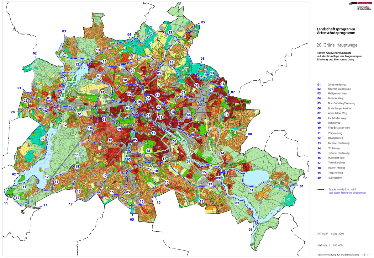
The Humboldt Lane is marked with the number 16, one of the 20 main green paths . This is a compilation of 20 hiking trails through the Berlin urban area with a total length of around 550 kilometers. The aim is to link “residential areas with the diverse recreational opportunities in parks and local recreation areas in Berlin and Brandenburg ” (Senate Department for Urban Development and the Environment). The pedestrian should have the opportunity to “experience the city intensely as a combination of culture, history and ecology”. This hiking trail records the presence of the Humboldt family in Tegel Castle and opens up parks and green spaces in the north of Berlin.
course
.JPG)
The Humboldt-Spur runs over 34 kilometers from Tegel Castle, the residence of Alexander and Wilhelm von Humboldt , through Barnim on Nordgraben to Wuhle . The north ditch was created around 1930 as a water relief ditch for the Panke . To the east of the Panke, the Humboldt-Spur accompanies the Fließgraben, Hechtgraben and Seelgraben, some of which are well-developed, and connects the Wartenberger and Falkenberger Feldmark with the parkland of the Wuhletal. Between the Panke and Wuhle rivers, the route mostly runs away from built-up areas and through the green areas of Berlin's Barnim in the northeast of the city. The planned course still requires some workarounds,
In its course through the Barnim, the green main path 16 follows the (presumed) traces of the natural scientist brothers Alexander and Wilhelm von Humboldt, the western entry point on the Spandau bank of the Havel . The car ferry ( location ) between Aalemannufer in Hakenfelde and Jörsstrasse in Tegelort (the southern location in Konradshöhe ) brings interested parties across the Havel, near the northeast entry point of the Spandauer Weg and at the “Fährhaus Spandau” directly adjacent to one of the endpoints of the Havelseenweg Spandau- Reinickendorfer district border forms.
Konradshöhe

In Tegelort, a locality of Konradshöhe , the route leads south from the ferry on the banks of the Havel, past Marlenestrasse and Almazeile to the southwest corner of Tegelort. Here is a ferry landing whose passenger ferry connects Tegelort with Spandau-Hakenfelde to the islands of Valentinswerder and Maienwerder in Lake Tegel . The Humboldtspur continues along the water ( Friedericke and Beatestrasse , with the terminus of bus line 222 80 meters away) to Barschelplatz and here diagonally into Scharfenberger Strasse . Due to the waterfront location of the properties a little away from the bank, shortly afterwards turn right in the street Tegelorter Ufer to the accessible bank of the Tegeler See. There are many jetties along the entire shoreline. The Humboldtspur reaches the landscape protection area (LSG) Tegeler Forst , which is 280 meters along the banks of the settlement houses, and the Tegel district is reached when you enter it.
Tegel

The main route 16 leads for 3.5 kilometers through the forest on the banks of the Tegeler See . At the boathouse Schwarzer Weg 50 on the shore and because of the riverside path sometimes through the forest, the Tegelsee air and outdoor pool is bypassed on the shore on the Schwarzer Weg. Before that, a path leads to the headland south below to the non-public car ferry on the island of Scharfenberg with a school farm and boarding high school. After the outdoor pool, the main path comes back to the bank and on the lake side in front of the rescue station and the “Toulouse de lac” restaurant. In the following, Villa Borsig requires you to deviate from the bank. The Federal University of Applied Sciences for Public Administration is located here on the Reiherwerder peninsula . Around the Großer Malchsee (the northern end of the Tegeler See), the main path returns to the Schwarzen Weg, after whose settlement houses 23–27 at the Fischerhütte, the Humboldt-Spur and Heiligenseer Weg meet. From here the last one goes west over the Mühlenweg through the forest to the eponymous district Heiligensee. Both paths follow the same route to the east, not far is the district forester's house and 50 meters to the left is the " Dicke Marie ", Berlin's oldest tree. The two main routes 03 and 16 leave the LSG and the forest on the north-east bank of the Großer Malchsee on the way (later as a road) An der Malche , on the right the lake, on the left the Tegel leisure park, to which the Tegel Castle Park connects to the north. A small tributary, the Malchseegraben, will be bridged and next to the tennis courts to the lookout point and monument at the transition from Malchsee to Tegeler See. With the green riverside path (necessarily to the east) at the outflow of the Tegeler Fließ ( location ), the Tegeler Hafenbrücke , popularly known as the Sechserbrücke, is reached.
.jpg)
The Tegeler Hafenbrücke spans both the Tegeler Fließ and the access to the Tegeler Hafen, at the other end of which the Nordgraben flows. Hauptweg 16 uses the bridge ramp and continues along the south quay of the port. Hauptweg 03 runs south to Greenwich Promenade, on this route the Barnim Dörferweg (No. 13) begins 100 meters further, with which the Humboldt Lane continues. To the right of the paths are buildings that remained from the 1987 International Building Exhibition . The route remains on the bank around the Humboldt Island at the end via Alexander-, Wilhelm- and Karolinensteg. The last over the Nordgraben and the way further through the green corridor on the Nordgrabenufer (Medical Park Humboldtmühle ) , the Karolinenstraße (because of the Karolinenbrücke) is crossed at the intersection with An der Mühle / Waidmannsluster Damm and used back to the Nordgraben. In the continuing green corridor - opposite the surface water treatment at Nordgraben - you reach Buddestrasse and the sidewalk at Waidmannsluster Damm leads through the S-Bahn route (to Hennigsdorf) and the A 111 . Behind the autobahn take Hauptweg 13 to the left and No. 16 to the south to the north ditch, first on its north side (not accessible from the Tegel cemetery on the south) via Wilhelm-Blume-Allee on the bridge of Ziekowstraße and change to the south and between the canal and "Kolonie Ziekowstraße" and sports field near the houses on Havelmüllerweg . Between Rohrbrunner Straße and Tile-Brugge-Weg, the Packereigraben , where the district boundary of Wittenau runs, opens up . The Humboldt-Spur lies on the Nordgraben initially in Tegel and changes to this district at the Gorkistraßenbrücke , which means that the Borsigwalde on the southern bank of the Nordgraben cannot be reached.
Wittenau

The Humboldt lane also runs in the green corridor on Nordgraben (at the KGA 'Grünlandtal') in Wittenau and on the street In den Kaveln , a bridge over the Kesselpfuhlgraben leads to Triftstraße (KGA 'Am Rathaus'). This is followed by Eichborndamm , to the left the Reinickendorf town hall and across the street in Peter-Witte-Park the Rathaus Reinickendorf underground station . Furthermore, on the left side of Taldorfer Weg, there is the green space at Kranichpfuhl, Oranienburger Straße ( B 96 ) and the tree-lined Roedernallee are crossed (afterwards: KGA 'Am Nordgraben').
Reinickendorf
Another change over the Nordgraben on the Schorfheidestrasse to the street Am Nordgraben and for 100 meters in the district Reinickendorf .
Märkisches Viertel
By S-Bahn bridge turn from Reinickendorf district in the district of Pankow , the district Wilhelmsruh to Heinz-Brandt-Strasse . On this street, however (formerly: East Berlin ), the Mauerweg coming from the railway embankment and Hauptweg 04 continue on the south side of the north ditch, the Humboldtspur enters the north side at this point of contact and thus comes into the Märkisches Viertel . Heinz-Brandt-Strasse was laid out on the strip of wall cleared in 1990 as part of the planned north bypass , but remained without a connection to the east. The green strip on both banks has been declared a LSG .
Rosenthal
Lehmweg_weiterOst.JPG)
The Humboldt-Spur remains on the north side of the north ditch and thus changes from the Märkisches Viertel to Rosenthal . On the following railway line of the former Reinickendorf-Liebenwalder Bahn , the industrial line for Bergmann-Borsig , the Lübarser and Mauerweg come from Wilhelmsruh over their Nordgrabenbrücke, they then continue on the railway line to the north. The Humboldtspur remains at the Nordgraben and changes to the Pankow district of Rosenthal . On the left is the Gauert complex, behind it the Wilhelmsruh cemetery with a war cemetery. It is the Uhlandstraße reached and crossed. From Uhlandstraße ( Lage ) you go to the KGA 'Rosenthal-Süd' on the Nordgrabenuferweg across the main street into the Wördenweg, past the KGA 'Humboldt' over the Friedrich-Engels-Straße and onto Nesselweg and An der Priesterkoppel , Straße 140 , Schönhauser Strasse through the settlement area.
The Nordgrabenbrücke is used on Schönhauser Strasse and the Humboldt Spur follows the Nordgraben against its direction of flow on the mountain herb path through the 'Einigkeit' facility. In this large garden, the paths were named as dedicated private streets after herbal terms in 2013 , in order - as in some other settlements in the Pankow district - to provide them with georeferenceable building addresses. After 140 meters from Schönhauser Strasse, the Zingergraben , located in a bush zone, crosses , which was cut into two runs around 1930 by the deep northern trench. And 520 meters further is the Blumenwegsteg , via which the Frauenmantelweg connects the separate parts of the 'Unity' complex. Finally, there is a trench piping at the end and the green main path 16 changes for 40 meters to the herb path triangle to lead on the medicinal herb path to the Blankenfeld district boundary and to the right to Blankenfelder Chaussee / Dietzgenstraße ( Lage ).
Niederschönhausen
At the Dietzgenstrasse, the Nordgrabenlauf is the place for the change in the street name of the B 96a , although the district boundary is 50 meters further north. With the change of the side of the street there is a water management system on plot 192/194, which is hidden in the bush. The course of the main path continues a little to the south (to the right) around the area of Dietzgenstrasse 190 on the embankment on the Rosenthaler side, while the low-lying bank of the water forms the border to Blankenfelde. To the right of the path are the 'Daheim' facility (now with street names after rocks) and the 'Frohsinn' facility across the north ditch. The Blankenburg settlement complex 'Frohsinn' with street names according to French regions ends at the local border with French Buchholz . Here the Humboldt-Spur changes over the Friedenswegbrücke into this district. Since Blankenfelde goes to the southern edge of the water, on the other hand the border Rosenthal / French Buchholz goes diagonally over this, the bridge is up to the middle above the north ditch in Blankenfelde, so that the main path still goes a little through Blankenfelde .
French Buchholz
At the north ditch is the name of the road in the French part of Buchholz . The Humboldt-Spur leads between the Nordgraben and the Buchholz settlement (a facility that has been rededicated by a KGA ) to Schönhauser Strasse . The further ideal tour on the north side of the north trench to its drainage from the Panke is currently not accessible and so the green main path leads through the commercial area of the Marienstraße to Pasewalker Straße . On this 320 meters to the right, over the former route of the industrial railway Tegel – Friedrichsfelde (between Pasewalker Straße 41 and 87a) and then to the left into Blankenburger Weg . The green space around the Panke basin, where the north ditch drains from the Panke, begins at road 42 . The main path uses the local Pankebrücke , where the north-south path (main path no. 05 along the Panke, also known as the Berlin – Usedom long -distance cycle path ) is crossed. The main path 16 continues straight ahead on the disused industrial railway line, past the adjacent facility 'Blankenburg' (left, Buschsperlingweg ) and the green area (right) towards the Blankenburg carp pond. The Blankenburg district is reached on the Steinsperlingweg over the river ditch and then through the motorway bridge ( Lage ).
Blankenburg
In Blankenburg, the Grünkardinalweg is the wide path through the Blankenburg facility, the Humboldt track continues through the railway bridge of the Stettiner Bahn and goes to the left at the embankment on the Rotkardinalweg (past Tigerfinkweg and Reisfinkweg ) to the Papstfinkweg at the flow ditch, the one here 30 meters wide green zone and an inflow ditch from the plant. At the Graben on the Rotkardinalweg continue to the right, the Schwirrammerweg , the continuous Rohrammerweg on the Safranammerweg, then follow the Singammer- , Schneeammer- , Fuchsammer- , Zwergammerweg which end at the Graben. On the Erlenzeisigweg , the water management area of the retention soil filter for the river ditch water begins on the right . The main path to Heinersdorfer Straße goes over the Schäferstege (a continuous investment path over a river ditch bridge) , and over this continues along the river ditch between the buildings on the right of the HTW site, which was abandoned in 2009 (once popularly known as the "farmer's college") and Opposite the rehabilitation center Wohnstätte Krugstege. At the Henzesteg , the north bank of the river ditch turns 50 meters into Parkstrasse and to the right in Am Fließ , it goes south of the listed village center of Blankenburg to Georgenstrasse and Ziegelstrasse .
Malchow suburb
At the Fließgraben at the corner of Am Fließ / Ziegelstraße, the Suderoder Graben opens from the north on which the district boundary is located. When you reach the suburb of Malchow , the path before the inflow of the pest ditch leads over the flow ditch on its south side to the nine-hole course of the golf resort Pankow, which is located in the (large-scale planning area) "North-East Nature Park". The course to the south-east then continues with the flowing ditch through the golf course over the Blankenburger Pflasterweg through arable and meadowland, former sewage fields of the Rieselgut Blankenburg, which is why some more ditches open up. To the east of the allotment garden 'Märchenland', the largest in Berlin, you change over to the Märchenweg and at the Lindwurmgraben follow the course of the flowing ditch to the left. Further on the Ortnitstraße over the Malchower Chaussee ( B 2 ) you enter Malchower Flur , the change of the districts Pankow to Lichtenberg .
Malchow
In Malchow , the Humboldt-Spur is north of the “Green Campus Malchow” (a sports area) and the path leads around Malchower See on the Grabenlauf through the Malchower Auenpark into the green zone between the Niles settlement (already in Neu-Hohenschönhausen) and Malchower See. The Hechtgraben, which accompanies the Humboldt Lane for 150 meters to the east, is reached 90 meters on its west bank. Here the main path leads to the north (left) in Malchow through meadows with trees and bushes to Wartenberger Straße , which is followed to the right.
Wartenberg
Wartenberg is reached under the railway bridges of the Berlin outer ring ( freight traffic , RB 12 and OE 60 ) on Wartenberger Straße and at the level of the Margaretenhöhe path it goes again (left against the direction of flow) along the Hechtgraben , the Neu-Hohenschönhausen district remains at it South bank. About 750 meters on the direct route away from the bank, Hauptweg 16 meets Hauptweg 06 ( Lindenberg corridor from the city center) and both have a shared route of 250 meters. While Hauptweg 06 continues northwards in the direction of Lindenberg in front of street 10 , the Humboldt-Spur turns south to the sports field and there again to the left at Hechtgraben around the horticultural area. On Lindenberger Straße , diagonally opposite the Green Trift, past a small wood, then through fields to the Falkenhöhe settlement in 1932. When this has been crossed, the transition from Wartenberg to the Falkenberg district follows after 270 meters .
Falkenberg
In Falkenberg there is a pet cemetery on the left and behind it the orchard meadow 'Schulzenkate'. At the southwest corner of the Berlin animal shelter , turn right at the old fruit plant on Stegeweg at Gutspark Falkenberg to Dorfstraße , which is used to the right. Between their properties 3b and 4a, a road goes to the left, which is followed by the main path into the LSG 'Falkenberger Wiesengräben', which then continues eastwards. Hauptweg 06 comes up to 80 meters from the west, but then goes south to the NSG 'Falkenberger Krugwiesen'. The path a little bit from the Seelgraben in the LSG brings the Humboldt-Spur to Hohenschönhauser Straße , at the eastern edge of which the change of district to Marzahn (Lichtenberg district to Marzahn-Hellersdorf ).
Marzahn
In Marzahn following the Hellersdorfer Weg in the Seelgrabenpark (west) to the Wuhle and this to the Köthener Straße , on which the Köthener bridge (instead of the scheduled way to the railway) crosses the Wuhle and the Wuhletalstraße is reached to the left. The Wuhletalstraße in Marzahn allows for the green Hauptweg 16 to change from Seelbuschgrabenpark (west) to Seelgrabenpark (north) under the railway bridge of the S-Bahn and regional trains and the Wuhletalbrücke ( Märkischen Allee ). Along the bridging cross street and crossing the northern driveway arch, it continues north of the Neue Wuhle, before the residential blocks of the Flämingstraße and the sports areas, over the tracks of the tram line M8 to the northern Blumberger Damm bridge (a Wuhle bridge) next to which the Kemberger Straße is crossed. Another 400 meters (in addition to the pasture for highland cattle), the main path 16 meets the north-south-running main path 14 ( Wuhletalweg ), which bridges the Wuhle from the oak park to the landscape park Wuhletal (and park on the pasture ground ) on the Ahrensfeld mountains . When the two main routes meet, the eastern end point of the Humboldt track ( Lage ) is reached. As a conclusion for hikers and pedestrians, there are stops on bus line 197 in Kemberger Straße: 220 meters south on Wuhletalstraße and 280 meters north on Belziger Ring.
Local transport connections
Via the Alt-Tegel underground station ( line U6 ) you can reach the Humboldt lane at Tegeler Schloss in the harbor area, connection to public transport is provided by the Rathaus Reinickendorf underground station ( line U8 ) and halfway to the Blankenburg station (lines S2 and S8). Further connections and entry points are the intersections of the main route with the tram and bus lines.
literature
- Hiking map Berlin City. Strolling - walking - hiking . 1st edition. piekart, Berlin 2012, ISBN 978-3-935863-22-3 .
Web links
- 20 Green Main Paths , website of the Berlin Senate Department for Urban Development and the Environment, accessed on January 5, 2014.
- Overview map of the 20 hiking trails , website of the Berlin Hiking Association, accessed on January 5, 2014.
Individual evidence
- ↑ a b path number: 16
- ↑ FUSS e. V.
- ↑ The BUND project "20 Green Main Paths"
- ↑ Project "20 Green Main Paths® in Berlin"
- ^ Association for hiking in the LSB Berlin
- ↑ Senate Department for Urban Development and the Environment , Unit IE Nature Conservation, Landscape Planning and Forestry
- ↑ Chronicle of the 20 green main routes on berlin.de
- ↑ 20 main green paths. In: Website of the Berlin Senate Department for Urban Development and the Environment. Retrieved January 31, 2017 .
- ↑ The BUND project “20 main green paths”. In: BUND website . Retrieved January 31, 2017 .
- ^ Restaurant Fährhaus Spandau
- ↑ Tegeler See ferry
- ↑ Sights: Freizeitpark Tegel ( Memento of the original from July 14, 2014 in the Internet Archive ) Info: The archive link was inserted automatically and has not yet been checked. Please check the original and archive link according to the instructions and then remove this notice.

01 Spreeweg | 02 Spandauer Weg | 03 Heiligenseer Weg | 04 Lübarser Weg | 05 North-South Path | 06 Lindenberg Corridor | 07 Hönower Weg | 08 Kaulsdorfer Weg | 09 Dahmeweg | 10 Britz-Buckower Weg | 11 Wannseeweg | 12 Havelseenweg | 13 Barnimer Dörferweg | 14 Wuhletal hiking trail | 15 Teltower Dörferweg | 16 Humboldt track | 17 Teltow Canal Path | 18 Inner parking ring | 19 Tiergartenring | 20 Bullengrabenweg