Long-distance cycle route Berlin – Usedom
| Long-distance cycle route Berlin-Usedom | |
|---|---|

|
|
| overall length | 337 km |
| location |
|
| map | |
| Starting point | Berlin |
| Target point | Usedom |
| Connection to | Berlin – Copenhagen cycle route |
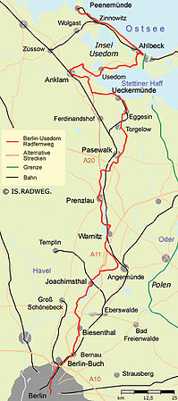
The Berlin – Usedom long-distance cycle route is a long -distance cycle route in the federal states of Berlin , Brandenburg and Mecklenburg-Western Pomerania . Its implementation began in 2002; the official opening by the ADFC took place on August 30, 2007.
The long-distance cycle path leads over a length of 337 kilometers from Berlin-Mitte through the Barnimer Land , the Uckermark and through Western Pomerania to Peenemünde on the island of Usedom . It will continue to Stettin via Wolin Island .
Routing
The name Pankeradweg is also used from Berlin to Bernau.
Berlin
In Berlin, the long-distance cycle path is part of the cycle and hiking path along the Panke . Since July 2010, this has led mainly asphalted and expanded to Bernau in the Pankequell area.
-
Berlin center
- Start at Schloßplatz on the Spree Island
- Past the Berlin Cathedral , the Old Museum and the Old National Gallery and Bodestrasse over the Friedrichsbrücke into Anna-Luise-Karsch-Strasse.
- The path crosses Spandauer Strasse and then comes to Rochstrasse. He crosses Münzstraße and comes to Max-Beer-Straße.
-
Prenzlauer Berg
- On Schönhauser Allee past the former home of the director Ernst Lubitsch (Schönhauser Allee 183), a view of the Sacred Heart Church (1898) in Fehrbelliner Strasse and past the listed, former Pfefferberg brewery .
- At Senefelderplatz (on which there is a monument to Alois Senefelder ) the path turns left into Schwedter Straße and then crosses Kastanienallee .
- The path touches Oderberger Strasse and crosses Bernauer Strasse .
- Through the Mauerpark , past the Friedrich-Ludwig-Jahn-Sportpark and the Max-Schmeling-Halle .
- Then turn right into Gleimstraße (quieter and better developed alternative route between Mauerpark and Schlosspark Pankow: see below) and Sonnenburger Straße to the left.
- Cross the S-Bahn and continue to Bornholmer Straße . Turn right into this, then turn left into Berliner Straße and continue on to Schlosspark Pankow.
-
Berlin-Pankow
- along the river Panke through the palace gardens with Schönhausen palace
- Blankenburger Karpfenteiche, then through French Buchholz via Bahnhofstrasse, Strasse 59 and Ludwig-Quidde-Strasse to Strasse 74, then right to the motorway pedestrian bridge to Karow.
- Berlin-Karow
-
Berlin book
- Castle Park Buch
country Brandenburg
Barnim
-
Bernau near Berlin
- Ladeburg with village church
- Lobetal , Alte Schmiede as a tourist meeting point, Mechesee with swimming area
- Langerönner Mühle ( Rüdnitzer Fließ ), nature reserve Biesenthaler Becken
-
Biesenthal Catholic Marienkirche, newly reconstructed town hall, lido at the Großer Wukensee
- Hellmühler Fliess
- Wehrmühle, River Finow , bridge over Autobahn 11
- Pregnitz flow
- Grafenbrücker mill, Grafenbrücker lock
- Finow Canal
- Marienwerder
- Oder-Havel Canal
-
Werbellinkanal
- Rosenbeck (Rosenbeck lock) and Eichhorst
- Wildau ( Askanier Tower ) on the Werbellinsee
-
Werbellinsee
- Hubertusstock with a former hunting lodge
- Waldhof
- Elsenau
-
Joachimsthal with Kaiserbahnhof , Schinkel Church
- Dovin Lake
- Glambeck half-timbered church (Radlerkirche) from 1708, pigeon tower , Glambeck lake , Radlerpoint: cyclist information point, underpass under the BAB 11
Uckermark
- Wolletz at the Wolletzsee
- Blumberger Mühle NABU adventure center (west of Angermünde ).
- Fish ponds
- Görlsdorf with early classical hall church, Lenné castle park , gatekeeper house
- Peetzig on the Great Peetzigsee
-
Steinhöfel over the motorway bridge BAB 11 , Koppelberge 63.3 m high
- Stegelitz
- Schifferhof, Great Lanke of the Oberuckersee
-
Oberuckersee (685 ha of water with castle wall island )
- Warnitz with campground, train station, bathing facilities, passenger ship “ Onkel Albert ”, observation tower on the bypass road in the direction of Melzow, the cycle path continues parallel to the railway line to the north
- Quast with bathing beach, route further through the half-barrier over the Höhnesweg around the Krummen See to Seehausen.
- Seehausen with a train station
- Ucker (river / canal)
- Potzlow ( Roland statue on the market square)
- Strehlow
- Zollchow
-
Unteruckersee
- Röpersdorf am Unteruckersee
-
Prenzlau ( Marienkirche , Dominican monastery, city wall, Slavic boat Ukrasvan ), train station
- River Quillow
- Vossberg (viewpoint at 37.6 m height)
- Ellingen
- Schönwerder
- Bandelow
- Trebenow with large stone grave (about 700 meters southeast of the church, in front of the southern entrance to the village)
- Advertising low
- Nechlin
Mecklenburg-Western Pomerania
- Low
-
Pasewalk with St. Nikolai Church (13th century), Marienkirche ( largest church in Western Pomerania ), city wall towers, museum in Prenzlauer Tor , train station
- Friedberg
- Viereck, Stallberg and Drögeheide with barracks and military training areas in the " Land of the Three Seas ": " Forest-Sea, Sand-Sea, Nothing More " (Soldier's saying of several generations)
-
Torgelow with castle ruins and Christ Church, Slavic craftsmen's settlement from the 9th century ( Ukranenland ), train station
- Torgelow Dutch factory
- Eggesin with the neo-Gothic brick church, train station
- Hoppenwalde with train station
-
Ueckermünde with city palace / Pomeranian palace with a tower that can be seen from afar and the Haffmuseum, Marienkirche, city harbor, train station, Haffbad and zoo
- Grambine
- Mönkebude
- Leopoldshagen
- Bugewitz (Dammweg)
- from May to September the route can be shortened by ferry from Kamp to Karnin. Passing the railway lift bridge , the section around Anklam is no longer necessary.
- Anklam ( bascule bridge near Zecherin )
-
Usedom Island
- Usedom (city)
- Ahlbeck
- Peenemünde (along Peenestrom)
Abbreviations and alternative routes
Alternative route Prenzlauer Berg – Pankow
For the route between Mauerpark (Prenzlauer Berg) and Schlosspark Pankow:
After the Mauerpark, continue along the signposted Berlin Wall Trail to the Schwedter Steg, with a view of the North Cross of the Berlin Railway. Pass the Bornholmer Straße S-Bahn station . Only leave the Berlin Wall Trail at Bürgerpark Berlin-Pankow . Cross the Bürgerpark along the Pankeweg , which is also signposted . The Pankeweg meets the now well-developed route of the Berlin-Usedom long-distance cycle path in the Pankow Palace Park with Schönhausen Palace .
Abbreviation Werbelow – Bugewitz
For the route from Werbelow via Ferdinandshof to Bugewitz:
Brietzig, Wilsikow, cross the B 104, over the motorway bridge to Lukow, Klein Lukow, Friedrichshagen to Ferdinandshof, Demnitz, over the Zarow river to Altwigshafen, cross Neuendorf A, B 109, Altwigshafen, the disused train station Borckenfrieden, Heidberg and Bugewitz.
Abbreviation Glambeck – Steinhöfel
It is possible to use the shortcut from Glambeck to Steinhöfel to save yourself the trip via Angermünde .
Train stations
The route is also passable in sections. With the exception of the area around the city of Usedom, a place with a train station can be found every 30–45 minutes. The following train stations can be used along the long-distance cycle path:
Train
- Line S 2: Berlin Friedrichstrasse , Berlin-Gesundbrunnen , Bornholmer Strasse , Pankow , Blankenburg , Berlin-Karow , Berlin-Buch , Röntgen , Zepernick , Bernau near Berlin
- Line S 8: Bornholmer Straße , Berlin-Pankow
- Lines S 5, S 7, S 75, S 9: Berlin Alexanderplatz
- Lines S 1, S 2, S 25, S 41, S 42: Berlin-Gesundbrunnen
- Lines S 1, S 2, S 25, S 8, S 85: Bornholmer Straße
Railway lines
- Berlin Alexanderplatz : RegionalExpress RE 1, RE 2, RE 7, RB 14
- Berlin-Gesundbrunnen : RE 3, RE 5, RE 6, RB 19, RB 27, RB 66, IC / ICE
- Bernau near Berlin : RE 3, RB 24, RB 66, IC
- Biesenthal : RE 3, RB 24
- Joachimsthal : RB 63
- Angermünde : RE 3, RB 61, RB 62, RB 66, IC / ICE (approx. 5 km from the long-distance cycle path)
- Warnitz : RE 3, RB 62
- Seehausen : RE 3, RB 62
- Prenzlau : RE 3, RB 62, IC / ICE
- Nechlin: RE 3
- Pasewalk : RE 3, RE 4, IC / ICE
- Torgelow : RE 4
- Eggesin : RE 4
- Hoppenwalde: RE 4
- Ueckermünde : RE 4
- Ducherow : RE 3 (approx. 5 km from the long-distance cycle path)
- Anklam : RE 3, IC / ICE
- UBB Usedomer Bäderbahn (with connection to the RE 3 in Züssow in the direction of Berlin) UBB stations: Peenemünde , Karlshagen , Trassenheide , Zinnowitz , Zempin , Koserow , Kölpinsee, Ückeritz , Bansin , Seebad Heringsdorf , Seebad Ahlbeck , Ahlbeck border
literature
- Sabine Kostka, Detlef Kaden: Out and about on the Berlin-Usedom long-distance cycle path . A travelguide; on CD-ROM: GPS tracks. IS.Radweg, Berlin 2006, ISBN 3-9810029-3-8 .
- Long distance cycle route Berlin-Usedom: from the metropolis to the Baltic Sea . an original bikeline bike tour book; [Bike tour book and map 1: 75000]. Esterbauer, Rodingersdorf 2006, ISBN 978-3-85000-203-5 .
- Berlin-Usedom cycle path . Cycling map 1: 50,000. Publicpress, Geseke, ISBN 978-3-89920-351-6 .
- Michael Faber, Jürgen Thesing (Eds.): Cycle Path Berlin-Usedom . Complete travel guide. Velo-Touring, Berlin.
- Berlin-Usedom - From the capital to the Baltic Sea . Compact spiral 1: 75,000, BVA Bielefelder Verlag 2008, ISBN 978-3-87073-436-7 .
Web links
- Current GPS track Berlin-Usedom (different formats)
- The Berlin-Usedom long-distance cycle route
- Tourism associations of Western Pomerania and Brandenburg (German, Polish, English)
- BicycleRoutes & Tours: Berlin-Usedom
Coordinates: 52 ° 31 ′ 5.9 ″ N , 13 ° 24 ′ 3.6 ″ E


