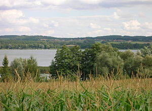
Oberuckersee
| Oberuckersee | ||
|---|---|---|

|
||
| View from the west bank, in the background the village of Warnitz | ||
| Geographical location | Uckermark district | |
| Tributaries | Ucker from above the Großer Krinertsee , outflow of the Potzlowsee , Stierngraben from the Stiernsee | |
| Drain | Ucker (channel) to Unteruckersee | |
| Places on the shore | Warnitz , Quast | |
| Location close to the shore | Prenzlau | |
| Data | ||
| Coordinates | 53 ° 11 '26 " N , 13 ° 51' 38" E | |
|
|
||
| Altitude above sea level | 17.8 m above sea level HN | |
| surface | 6.85 km² | |
| volume | 57,000,000 m³ | |
| Maximum depth | 28.0 m | |
The Oberuckersee is located in the northeast of Brandenburg in the Uckermark district . It has a water surface of about 685 hectares. It is the second largest lake in the course of the Ucker , after which both it and the Uckermark are named.
The towns of Warnitz and Quast are located on the lake shore in the east . In the north is the village of Seehausen . The village of Fergitz is on the west bank . The first-mentioned places belong to the municipality of Oberuckersee , the latter to the municipality of Gerswalde .
description
In Stegelitz at the southern tip of Oberuckersee the river rises Ucker . The Ucker flows through the Ober- and Unteruckersee to the north, is called "Uecker" in Mecklenburg-Western Pomerania and flows into the Stettiner Haff (Oderhaff or Kleines Haff) at Ueckermünde opposite the island of Usedom .
The Oberuckersee has a length of about five kilometers and a width of about 1.6 kilometers and is about 25 meters deep at its deepest point. It has a catchment area of almost 23 km². On the 4.5 km to the Unteruckersee the Ucker is canalised and navigable.
The lake is strongly structured in the north and south. In the north there are two distinctive bays, the Lanke with two smaller islands and the bay in which the Uckerkanal begins. In the south, the lake ends in the elongated Große Lanke bay .
The federal motorway 11 runs not far to the east of the lake .
Naming
Around the 6th century, the Ukranians immigrated to the Uckermark . The center of the tribe was around the Uckerseen Ober- and Unteruckersee.
Burgwallinsel in Oberuckersee
Around 1100 a larger Slavic feudal castle and settlement center was built on the Burgwallinsel in Oberuckersee . The rampart was five to six meters wide (at the foot) and about six meters high. The ramparts consisted of wood and clay.
Around 1150 the island was destroyed by fire. The wall glowed and slagged. Even today you can find stones with air pockets in the wall fortifications, the so-called floating stones.
Land connections
Earlier land connections to the island were a 2.2 kilometer long bridge ( long bridge ) in the north to Seehausen on the northern bank and thus an important trade connection to Prenzlau . A 400 meter long bridge ( short bridge , also: deep bridge ) made of oak wood to Fergitz led to the western bank.
The Long Bridge runs along a shoal, which today is one to two meters deep and in Slavic times possibly ran partly over marshland. The short bridge leads over a place up to 18 meters deep. In the early Middle Ages, these bridges were among the most important engineering achievements of the Slavs between the Oder and Elbe.
The Uckerseen area underwent a historically significant development in the 14th century due to the influence of the Marienwerder Cistercian convent in Seehausen, which at that time stood on the peninsula.
The castle wall island is now privately owned .
tourism
Wall path
The Oberuckersee with Burgwall island is in the routing of the Wall path involved (historical sites).
Long-distance cycle route Berlin-Usedom
The long-distance cycle route Berlin – Usedom leads along the lake from the Große Lanke via Warnitz and Quast to the Lanke to Seehausen.
Ucker / Uecker
The Ucker is navigable by boat from the Oberuckersee, but only navigable as far as the Unteruckersee (see above). After that it is a paddling water. Only from Eggesin at the mouth of the Randow can it be used again with larger boats.
Region / origin
The lake is located in the Uckermark as part of a moraine landscape that was shaped by the Ice Age . The receding ice masses left behind a hilly flat land that is dotted with many small lakes. These lakes, as well as the Oberuckersee, are a remnant of residual ice stocks that collected large amounts of water when thawing in the hollows and depressions.
The lake is one of the largest of the 250 lakes in the Schorfheide-Chorin Biosphere Reserve .
See also
Web links
- Documentation of the condition and development of the most important lakes in Germany , part 5: Brandenburg (PDF; 1.92 MB) at TU Cottbus


