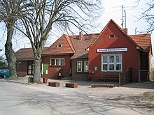
Warnitz (Oberuckersee)
|
Warnitz
Oberuckersee municipality
Coordinates: 53 ° 11 ′ 0 ″ N , 13 ° 52 ′ 36 ″ E
|
|
|---|---|
| Height : | 27 m |
| Area : | 40.17 km² |
| Residents : | 800 (Feb 21, 2018) |
| Population density : | 20 inhabitants / km² |
| Incorporation : | December 31, 2001 |
| Postal code : | 17291 |
| Area code : | 039863 |
The village of Warnitz is located in the northeast of Brandenburg on the east side of the Oberuckersee and was first mentioned in the 14th century. The stone church typical of the Uckermark is a reminder of this time.
Warnitz has belonged to the municipality of Oberuckersee since the merger of the previously independent municipalities of Blankenburg, Potzlow , Seehausen and Warnitz on December 31, 2001 .
geography
The place Warnitz with the suburbs Grünheide, Melzow, Trumpf, Neuhof and Quast lies in the biosphere reserve Schorfheide-Chorin (landscape protection area - zone III).
In the village and in the immediate vicinity there are a number of smaller lakes , which were formed as remnants of residual ice from the Vistula Ice Age . The many boulders that can be found in the vicinity of the place also date from this time .
To the north is the district town of Prenzlau at a distance of about 18 km. The federal capital Berlin is around 80 km to the south.
history
The Sundewit Warnaes is a reminder of the Warnen tribe who lived there. Warnitz is the first time as Warsize in a letter of protection from Dukes Otto I and Barnim III. named by Pomerania for the Seehausen monastery , which was exhibited in Stettin on September 1, 1332.
In 1375 Warsitz appeared in the Landbuch Kaiser Karl IV. And had almost only Slavic inhabitants.
In 1539 Warnitz came to the Gramzow-Seehausen monastery office. The original village was grouped around the field stone church , which was provided with a western tower in 1738, and the one-class village school.
From the 1960s, Warnitz became the dominant holiday resort on the Oberuckersee , with the camping site still existing today, which is located directly on the lake. In the school, built in 1960, children from the surrounding communities are also taught today.
On January 1, 1970, the previously independent communities of Grünheide and Melzow were incorporated into Warnitz.
Infrastructure
- Long-distance cycle route Berlin – Usedom
- Rail: Mainline Berlin – Stralsund
- Federal motorway: A 11 junction number 7
Attractions
- Burgwallinsel in Oberuckersee
- Field stone church (1738)
- Restaurant with its own brewery
- Observation tower
- Exotic animals
tourism
During the GDR era, many companies had recreational facilities here, such as the Maxhütte (Unterwellenborn) , the Schwedt petrolchemical combine and many smaller companies. The Ministry of Construction also had a training center here. Today these facilities are privately marketed.
The place with its campsite is now the tourist center on the Oberuckersee . The campsite is open from April 30th to September 15th. You can also rent rowing boats, paddle boats and kayaks, take tours with the passenger ship Onkel Albert or travel the rampart path.
The long-distance cycle route Berlin – Usedom runs through Warnitz .
Sons and daughters (selection)
- Gustav Kastner-Kirdorf (1881–1945), General of the Air Force
Individual evidence
- ^ Office Gramzow - residents' registration office (ed.): Population figures of the office Gramzow with the municipalities belonging to the office. As of February 21, 2018 . Gramzow February 21, 2018.
- ↑ StBA: Changes in the municipalities in Germany, see 2001
- ↑ Ludwig Schmidt : Again on Saxony Research , p. 350, 1928, in Walther Lammers : Origin and Constitution of the Saxon Tribe , p. 129, Frankfurt 1966
literature
- Lieselott Enders : Historical local dictionary for Brandenburg, Part VIII, Uckermark . Weimar 1986, ISBN 3-7400-0042-2
- Johannes Schultze (Ed.): The land book of the Mark Brandenburg from 1375 . Publication of the Historical Commission for the Province of Brandenburg and the Reich Capital Berlin, VIII, 2, Berlin 1940


