
Uecker


The Uecker (Ucker) is a 98 km long lowland river with a 2200 km² catchment area. The slowly flowing, varied river bears the name Ucker in its Brandenburg part and the name Uecker in Mecklenburg-Western Pomerania .
Names
The name of the river is closely related to the Slavic tribe of the Ukranians , named after the river , who had a fortified trading center on the Burgwallinsel in Oberuckersee . The river name was originally pronounced with a long u , the ck served in Low German (as opposed to High German) to stretch the preceding vowel. After the versions “Ucker”, “Uecker” and “Ücker” were used equally at times, the Federal Agency for Cartography and Geodesy has recently agreed on the traditional names: Ucker in Brandenburg, Uecker ([ ˈʏkɐ ]) in Western Pomerania . The interpretation of the Slavic water body name is unclear: In the past, “the fast one” was preferred, today “the meandering one”.
River course
The Ucker rises 1 km north of the district Ringenwalde of the municipality of Temmen-Ringenwalde at an altitude of a little over 57 meters above sea level and flows north. After less than 2 km you will reach the Großer Krinertsee . From there it flows through two smaller lakes (Mühlensee and Behrendsee) to Stegelitz and from there into the Oberuckersee . The connection from this through the Möllensee to the Unteruckersee has a height difference of only 10 cm, is canalised ( Uckerkanal ) and is navigable. It leaves the Unteruckersee at its northern end near Prenzlau . After about half way before the Stettiner Haff, the Ucker reaches Vorpommern near Nieden and now turns as Uecker to Pasewalk . Between Pasewalk and the estuary, the Uecker was blocked in the middle of the 19th century. Past Torgelow and Eggesin (where the Randow joins on the right ), the river continues to Ueckermünde and flows into the western part of the Stettiner Haff (Oderhaff), known as the Kleines Haff , in this easternmost German port city , which is connected to the Baltic Sea .

Legible display sizes: 20% (924 x 845 px) - 25% (1155 x 1057 px) - 33% (1540 x 1409 px)
Waterway
Today the Uecker is no longer important as a waterway. Only the 2.66 km long stretch of the mouth of the Uecker (Ue) through the Ueckerkanal (km 95.81 southwest edge of the road bridge in Ueckermünde to km 98.47 pier heads) is a federal waterway of class IV, on which the maritime traffic regulations apply. The Stralsund Waterways and Shipping Office is responsible .
Thanks to its partly idyllic course, it is a popular destination for paddling tours . The entire tour leads from Oberuckersee over around 82 km and can be completed in 3 to 5 days.
But the Uckerrinne also wanted the noble residents at the southern end of the Oberuckersee, v. Arnim auf Suckow , use it, partly for logging, partly for transporting bricks and fish . But with that he got in the way of the Prenzlau fishermen who had leased the fishing rights of the Gramzow office in Oberucker. Their best fish stocks were in the river between Seehausen and Potzlow and would be endangered by the Arnim ships. In 1716 the feudal lord promised to take the fishing times into consideration. But the resistance of the tenant fishermen grew, since v. Arnim (1751) had expanded his shipping and fishing more and more.
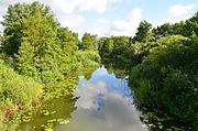
Ucker just below the Oberuckersee
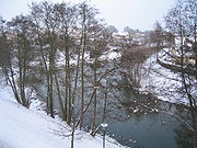
Mouth of the Uckerkanal in the Unteruckersee
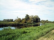
Uecker in Torgelow
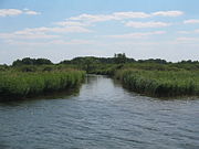
Uecker near Eggesin


Landscape area
Particularly noteworthy:
- the quiet, largely natural Uckermark landscape with meadows, fields, streams, lakes, "ghostly" polluted willows (Prenzlau mascot Willi Weide), dreamy villages and Slavic ramparts
- Burgwallinsel at the level of Warnitz and Fergitz in the Oberuckersee
- the Uckermark district town of Prenzlau with the Marienkirche from 1250 in north German brick Gothic , the Dominican monastery and the city wall
- City wall with city gates in Pasewalk
- The open-air museum Ukranenland , which is located on the outskirts of the town of Torgelow ( = trading center ), indicates the Slavic origin of the settlement of the Ueckern lowlands by the Ukranen tribe .
- Marienkirche and ducal castle in Ueckermünde
See also
Individual evidence
- ↑ a b Brandenburg-Viewer: DTK25 with the source of the Ucker; Inscription "Uckerquelle" only in the DTK50
- ↑ a b Map portal Environment Mecklenburg-Western Pomerania → Water → Waters → Running waters → LAWA routes → Query
- ^ German Hydrological Yearbook Coastal Area of the Baltic Sea 2005. (PDF) State Office for Environment and Nature Mecklenburg-Western Pomerania, accessed on October 4, 2017 (German, at: dgj.de).
- ↑ Lengths (in km) of the main shipping routes (main routes and certain secondary routes) of the federal inland waterways ( memento of January 21, 2016 in the Internet Archive ), Federal Waterways and Shipping Administration
- ↑ Directory E, serial no. 59 der Chronik ( Memento from July 22, 2016 in the Internet Archive ), Federal Waterways and Shipping Administration
- ↑ The Uckermark. Lieselott Enders , page 556
- ↑ StAP, Pr. Br. Rep. 7 Gramzow No. 688
literature
- M. Eckoldt (Hrsg.): Rivers and canals · The history of the German waterways . DSV-Verlag, Hamburg 1998