Köhntop
|
Köhntop upper course: Hechtgraben → Dieckgraben , Fürstenwerder to Wolfshagen: Landgraben , lower course: Schiefe Möhne |
||
|
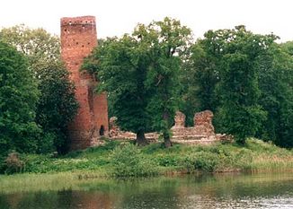
Blankenburg ruins on Wolfshagener Haussee |
||
| Data | ||
| Water code | DE : 9684 | |
| location | Brandenburg , Germany | |
| River system | Uecker | |
| Drain over | Ucker → Stettiner Haff | |
| source | at Helpter Berg 53 ° 28 ′ 49 ″ N , 13 ° 36 ′ 10 ″ E |
|
| Source height | 115 m above sea level NHN | |
| muzzle | at Nechlin coordinates: 53 ° 26 '12 " N , 13 ° 54' 42" E 53 ° 26 '12 " N , 13 ° 54' 42" E |
|
| Mouth height | 13 m above sea level NHN | |
| Height difference | 102 m | |
| Bottom slope | 1.9 ‰ | |
| length | 53.5 km | |
| Catchment area | 181.4 km² | |
| Flowing lakes | Woldegker Stadtsee , Kornowsee , Großer See , Dammsee , Haussee | |
| Communities | Fürstenwerder ( Nordwestuckermark ), Uckerland | |
The Köhntop is a 36.45 km, hydrographically but 53.5 km long river in the Uckermark in northern Brandenburg with its upper reaches in Mecklenburg-Western Pomerania . The 102 m difference in altitude between the source and the mouth is remarkable for its location in the North German lowlands . In view of the numerous lakes flowed through, the multiple name changes in the course are not unusual.
course
Upper course
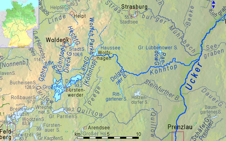
The upper reaches of the Köhntop rises in the Woldegker Heide on the south side of the Helpter Mountain from a spring pond, flows through the Woldegker Stadtsee (confluence 3.3 km, outflow 4.2 km from the source), and after another 10 km reaches the Kornowsee and its Outflow in 140 m the Great Lake near Fürstenwerder . In maps previously usually nameless, this stream reaches, according to information of the responsible Water and Soil Association Upper Havel Tollense the Woldegker city lake as Hechtgraben and then flows as Dieck digging from there to Kornowsee. Where it once formed the moat on the northern edge of Woldegk's old town, it is now piped up. The catchment area makes up 80% of that of the Great Lake. More than half, however, belongs to the 7.4 km long stream from Göhren (GKZ: 96842), which only reaches the Dieckgraben 2.6 km before it flows into the Kornowsee.
Big lake near Fürstenwerder
The upper course drains 80% of the catchment area of the Great Lake near Fürstenwerder . According to the state of knowledge of the Brandenburg environmental authority, its water level is above the surrounding groundwater level, so that it cannot have any underground inflows. Due to the rather dry climate of the lakes in the region, the evaporation of the water surface is on average greater than the amount of precipitation on it. Therefore, the outflow from the Großer See, i.e. at the beginning of the Köhntop by name, is not significantly greater than the inflow from the Dieckgraben.
Middle and lower reaches
North of the walled old town of Fürstenwerder, the Köhntop crosses the barely 300 m wide land bridge to the Dammsee . The subsequent 4.7 km north-east of the river to Wolfshagener Haussee are usually called Landgraben. Shortly before the Haussee, the second important tributary flows from the left, the 7.7 km long Wolfshagener Parkbach (GKZ: 96844). After leaving the lake, the river meanders mainly eastward. Behind the hamlet of Karlstein, its valley is cut about 20 m deep and designated as a nature reserve Köhntoptal . Below this valley, the Köhntop is also called the Schiefe Möhne . After a few kilometers you will reach the Ucker , which flows in a small glacial valley . The mouth is at Nechlin station ( Uckerland ) at 13.0 m above sea level. NHN and 1.2 m upstream that of the Strasburger Mühlbach .
Web links
Individual evidence
- ↑ MV-Viewer : Topogr. Click on maps, take out aerial photos → Display of DTK10
- ↑ Brandenburg viewer : DTK10
- ↑ Map portal Environment Mecklenburg-Vorpommern with topics watercourses, routes GWK, routes GWK stations, as well as query functions
- ^ State Office for the Environment, Health and Consumer Protection (LUGV), Brandenburg: List of waters. (River), Version 4.1., As of July 14, 2015. p. 31.
- ^ Map portal Environment Mecklenburg-Western Pomerania
- ↑ Page no longer available , search in web archives: Brandenburg-Viewer: DTK50 with underflow and mouth of the Köhntop

