Fürstenwerder
|
Fürstenwerder
Northwestuckermark municipality
|
||
|---|---|---|
| Coordinates: 53 ° 23 ′ 36 " N , 13 ° 35 ′ 6" E | ||
| Height : | 103 m above sea level NHN | |
| Residents : | 800 | |
| Incorporation : | November 1, 2001 | |
| Postal code : | 17291 | |
|
Location of Fürstenwerder in Brandenburg |
||
Fürstenwerder is a district of the municipality of Nordwestuckermark in the Brandenburg district of Uckermark with around 800 inhabitants .
location
Fürstenwerder is located in the hilly ground and terminal moraine landscape of the north-western Uckermark between the Dammsee and the Großer See directly on the border with Mecklenburg-Western Pomerania in the far north of the Uckermärkische Seen nature reserve . In the south of Fürstenwerder lies the Große Parmensee , in the southwest the Kiecker forest area, which is under nature protection, with the 127 meter high Splettberg . The closest larger towns are Feldberg (15 km) and Woldegk (7 km), both in Mecklenburg-Western Pomerania, as well as the district town of Prenzlau , 25 kilometers away , where the nearest train station is also located. The Brandenburg state roads L 243 and L 259 end in Fürstenwerder and meet the L 25 in the town center. The Uckermärkische Radrundweg runs through the village . Fürstenwerder includes the Wilhelmshayn settlements , a street tangler village east of the town center, Fiebigershof and Schulzenhof, the Ulrichshof and Kiecker residential areas and the Bülowssiege Vorwerk with an ensemble of listed field stone buildings consisting of a manor house and barns.
history
First mentioned in a document under the name Vorstenwerdere in 1319, Fürstenwerder developed as a Brandenburg border town to Mecklenburg in a strategically favorable location between the Dammsee and the Großer See and became a small town predominantly inhabited by craftsmen and arable citizens. The Middle Low German form vörste / vürste means not only prince in today's sense, but also ruler in general, but also foremost. Werder comes from Old High German, where uuerid / uuarid means "(half) island". In this respect, the name means front (st) e (pen) island .
Fürstenwerder lost its town charter, which was granted in the Middle Ages, after a prolonged economic stagnation and the associated decline in the number of inhabitants in 1817.
On January 29, 1847, a mail expedition and station for ordinary posts had been set up in Fürstenwerder, from which a cariole post to Wolfshagen connects to Wolfshagen three times a week (Sunday, Tuesday and Friday; 8 a.m. there and 4.30 a.m. back) leading Neubrandenburg - Prenzlauer Personenpost and to Wolfshagen- Pasewalker Kariolpost.
From its opening on December 2, 1902 to its closure on September 30, 1978, Fürstenwerder was the terminus of a railway line of the Prenzlauer Kreisbahnen to Dedelow on the line between Prenzlau and Strasburg . Another rail link, the last line from the direction of Templin operated by the Deutsche Reichsbahn , existed between 1913 and 1945. The two lines, which have since been dismantled, were not connected to one another and each had its own reception building in Fürstenwerder, which has been preserved.
Fürstenwerder lost its communal independence as a municipality on November 1, 2001 when the municipality of Nordwestuckermark was rebuilt, to which it has belonged ever since.
economy
The local economic life of Fürstenwerder is characterized by small businesses, crafts and agriculture. Tourism is playing an increasing role, supported by the location of the place in the north of the Uckermärkische Seen nature park.
Townscape
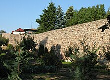
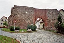
The town center is characterized by small towns and is surrounded by the city wall, which was built from field stones in the Middle Ages and partially preserved, and which was restored from 1996 to 1999. Of the original three city gates, the Woldegker and the Berliner Tor have been preserved, while the Prenzlauer Tor was demolished in 1878. The town church, built in the middle of the 13th century on a hill as a single-nave rectangular building with a transverse rectangular west tower made of field stones, burned down in 1740 and was then rebuilt. The tower top with slate lantern from 1786 comes from this time. The church has been called Heilandskirche since 2012 . The organ was built in 1877 by the Szczecin organ builder Barnim Grüneberg . From the outside the city wall windmill type tower Dutch only Stumpfbau from quarrystone and brickwork has been preserved.
See also: List of architectural monuments in Nordwestuckermark
Museums / exhibitions
- Uckermärkische Heimatstuben with exhibitions on local and regional history, housed in a former farmhouse from 1740
- Findlingsgarten on Woldegker gate with gathered from the Uckermark boulders
Sons and daughters of the place
The future geographer and explorer of West Patagonia, Hans Steffen, was born in Fürstenwerder in 1865 .
Trivia
Fürstenwerder is the intellectual, albeit artistically alienated, setting of the novel Before the Festival by Saša Stanišić .
Individual evidence
literature
- Lieselott Enders : Historical local lexicon for Brandenburg, Part VIII, Uckermark , Weimar 1986, ISBN 3-7400-0042-2
- Detlef Graf von Schwerin , Ute Bleich: Fürstenwerder and the Dominium - A Uckermark media city 1648–1854 , Verlag für Berlin-Brandenburg, Berlin 2007, ISBN 978-3-86650-631-2


