
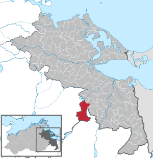
Strasburg (Uckermark)
| coat of arms | Germany map | |
|---|---|---|
.svg)
|
Coordinates: 53 ° 30 ' N , 13 ° 45' E |
|
| Basic data | ||
| State : | Mecklenburg-Western Pomerania | |
| County : | Vorpommern-Greifswald | |
| Height : | 64 m above sea level NHN | |
| Area : | 86.84 km 2 | |
| Residents: | 4635 (Dec. 31, 2019) | |
| Population density : | 53 inhabitants per km 2 | |
| Postal code : | 17335 | |
| Area code : | 039753 | |
| License plate : | VG, ANK, GW, PW, SBG, UEM, WLG | |
| Community key : | 13 0 75 130 | |
| City structure: | 27 districts | |
City administration address : |
Schulstr. 1 in 17335 Strasburg (Uckermark) |
|
| Website : | ||
| Mayor : | Heike Hammermeister-Friese ( CDU ) | |
| Location of the city of Strasburg (Uckermark) in the Vorpommern-Greifswald district | ||
 _in_SVO.svg) |
||

Strasburg (Uckermark) is the only Uckermark town in Mecklenburg-Western Pomerania . It is located in the district of Vorpommern-Greifswald and is free of office . The city is a basic center for its surroundings .
geography
Strasburg is located in the southeast of Mecklenburg-Western Pomerania, not far from the state border with Brandenburg . The ground moraines of the area reach average heights of 60 to 100 m above sea level. NHN . In the north of the municipality, Strasburg has a share in the Brohmer Mountains (heights up to 133 m above sea level ). Further north, the area to the Galenbecker See and the Friedländer Großer Wiese falls almost to sea level. Apart from a few smaller lakes with no outflow, such as the Demenzsee, the streams and ditches drain over the Mühlbach to the Uecker (Ucker). The nearest larger cities are Pasewalk and Prenzlau , the regional center Neubrandenburg and the metropolis Szczecin (Stettin) in Poland.
City structure
The following districts belong to Strasburg:
|
|
|
|
|
Neighboring communities
Strasburg borders the following communities (starting clockwise from the north): Heinrichswalde , Rothemühl , Uckerland , Mildenitz , Groß Miltzow , Schönhausen and Galenbeck .
history
13th to 15th centuries
The city's beginnings go back more than 750 years. Strasburg was founded in the 13th century by Duke Barnim I of Pomerania . With the spelling Straceburch , the place is mentioned for the first time in 1267. From the villages of Altstädt, Falkenberg and Jüteritz, he had the town laid out according to plan with an oval town plan and a grid-shaped road network. However, traces of Slavic settlement have already been documented from archaeological excavations . The town church of St. Mary was built between 1250 and 1280 and has been changed several times over the centuries. Strasburg was under Mecklenburg rule until 1323, only to be ruled by the Wittelsbachers from 1323 to 1373. It is recorded from the year 1348 that the False Woldemar was staying in the city. In 1433 Strasburg was the only city in the Uckermark to receive the right to mint coins . Own coins, the finch's eyes, were issued. The peripheral location in the border triangle of Brandenburg , Pomerania and Mecklenburg made Strasburg the target of numerous border wars. With the Peace of Prenzlau in 1479, the Uckermark, including Strasburg, became part of Brandenburg. Elector Friedrich I gave the city the privilege of founding a rifle company to defend the city, the Strasburger Schützen. Before 1538 Strasburg was in the fiefdom of the von Arnim family . In 1546 there was a big fire in the city. In 1599 the town hall was built, which was destroyed again in 1602 by another big town fire.
16th to 19th century
In 1612 craftsmen rebuilt the town hall. Through the settlement of numerous trades and guilds , the city experienced an economic boom in the 16th and 17th centuries, which only came to an abrupt end in the Thirty Years' War . There were also city fires in 1628, 1639, 1642, 1653 and 1681, during which almost all buildings were destroyed. Only one in ten citizens, around 200 people, survived the war. The existence of a first Jewish family is recorded from 1671 . From 1691 304 Huguenots , French religious refugees, came to the city, who from then on actively helped with the reconstruction. They introduced tobacco growing; potters, shoemakers and tanners came to town. The Adler pharmacy opened in 1733. In the following decades, the infrastructure was expanded: the town hall, which had been destroyed in the war, was rebuilt, roads to roads were paved, and electricity came to Strasburg. The rectory was built in 1760 and operated as a school from 1763 . In 1867 the city received a rail link to Pasewalk ; Travelers could use the newly built train station for this . At a later date, the connection to Neubrandenburg was extended. In 1882 a sugar factory was built. Due to the economic upswing, the number of residents and thus also the number of children increased. The newly built Red School therefore opened its doors in 1895 . It offered space for a total of 16 primary school classes. Before that, lessons took place in the rectory built in 1760, later the Suhr orphanage.

20th and 21st centuries
In 1927, the city's water tower was built on the initiative of Mayor Hermann Merck. He also campaigned for the construction of a cultural center and a city drainage system and had a promenade built on the city lake . During the Nazi era, the Bieber textile goods store on Altstädter Strasse was destroyed during the November pogroms in 1938 , but the Jewish cemetery remained untouched. The last three remaining Jewish residents were deported in 1943. In World War II Strasburg was destroyed around 55 percent and built up piece by piece until the 1950 / 1960s. However, a considerable part of the historical building fabric was destroyed in favor of prefabricated buildings. The town's local history museum was opened in 1975 in the former school building from 1760 .
After the fall of the Wall , new democratic elections were held for the first time in Strasburg in May 1990. The city center has been fundamentally renovated since 1991 as part of the urban development funding, including the local history museum in 1996. Since March 1st 1995 the official city name is "Strasburg (Uckermark)".
Administrative history
From 1817 to May 1945 Strasburg was a town in the Prenzlau district of the Prussian province of Brandenburg , from July 1945 in the province of Brandenburg newly constituted by the Soviet occupying power, which was renamed the State of Brandenburg after the official dissolution of Prussia in 1947 . With the dissolution of the states in the GDR in 1952, Strasburg came to the district of Neubrandenburg and became the district town of the district of the same name . In 1990 the town and district of Strasburg were incorporated into the newly constituted state of Mecklenburg-Western Pomerania. Although most of the Uckermark came back to the state of Brandenburg on the occasion of the new state formation in 1990, Strasburg remained with Mecklenburg-Western Pomerania due to the result of a referendum in 1991. In the course of the administrative reform in 1994, Strasburg lost its status as a district town and became part of the newly formed district of Uecker-Randow . Since the district reform in 2011 , the city has been in the Vorpommern-Greifswald district .
Incorporations
On September 9, 1992, the previously independent communities of Gehren and Neuensund were incorporated into Strasburg .
Population development
|
|
Status: December 31 of the respective year
politics
City council
The Strasbourg city council has 17 members. They have been distributed as follows since the local elections on May 26, 2019 :
| Party / group of voters | 2014 | 2019 |
|---|---|---|
| CDU | 5 | 4th |
| Citizens' alliance with competence for Western Pomerania | 2 | 3 |
| Initiatives for Strasburg (Um.) | - | 3 |
| The left | 3 | 3 |
| SPD | 4th | 2 |
| AfD | - | 1 |
| Community of voters Schöneres Strasburg | 3 | - |
| Individual applicant André Heise | - | 1 |
mayor
- 1896–1929: Hermann Merk
- 1929–1942: Hugo Oppermann
- 1945–1947: Otto Naumann (KPD / SED)
- 1963–1972: Kurt Hofrichter
- 1973–1975: Klaus Zuchanke
- 1975–1976: Günter Hahn
- 1977–1985: Karl-August Boelter
- 1986–1989: Kurt Tietz
- 1989–2015: Norbert Raulin (SPD)
- 2015–2018: Karina Dörk (CDU)
- since 2018: Heike Hammermeister-Friese (CDU)
Hammermeister-Friese was elected in the mayoral election on October 21, 2018 with 56.8% of the valid votes for a term of seven years.
coat of arms
|
|
Blasonierung : "In blue on corrugated water a golden castle with ungezinnter wall and three four-fold crenellated towers, the average larger than the two outer, all the towers with red pitched roof, golden and black Knauf window; the gate is covered with a silver shield with a gold-armored red eagle inside. "
The coat of arms was established around 1900, redrawn in 1997 and registered under the number 132 of the coat of arms of the state of Mecklenburg-Western Pomerania. |
| Justification for the coat of arms: In the coat of arms designed based on older seal images, the castle stands on the one hand as a speaking symbol for the final syllable of the city name, on the other hand it marks a fortified, well-fortified city. The sign refers to the former margraves of Brandenburg city lords and the water to the waters and swamps that used to surround the city. |
flag
The flag is striped lengthways with blue, yellow, blue, yellow and blue. The blue stripes on the upper and lower edges each take up a twelfth, the blue central stripe takes up a sixth and the yellow stripes each take up a third of the height of the flag cloth. In the middle of the flag cloth, on the blue median, overlapping two thirds of the height of the two yellow stripes, is the city coat of arms. The relation of the height of the flag cloth to the length is like 3: 5.
Official seal
The official seal shows the city arms with the inscription "STADT STRASBURG (UCKERMARK) * LANDKREIS VORPOMMERN-GREIFSWALD".
Town twinning
- Brodnica ( Poland )
- Drawsko Pomorskie (Poland)
- Strasbourg (Austria)
Attractions

- City church St. Marien , three-aisled hall made of brick, built between 1250 and 1280 and later redesigned into a high-Gothic hall church
- Catholic Church of the Holy Family , built in 1910 in neo-Romanesque style, branch church of the Pasewalk Catholic Church
- Town hall, built in 1849 in classicist style , renovated in 1999. The foundation walls of an earlier town hall from 1599 were found during the renovation of the market square.
- Medieval city wall, previously up to eight meters high, has been preserved in parts
- Local history museum of the city in a building from 1760 that was formerly used as an orphanage and school
- Former water tower, 36 meters high, built in 1928, surrounded by a restaurant and hotel
- Jewish Cemetery
- Memorial to the Victims of Fascism in Bahnhofstrasse (from 1968)
- City lake in the southeast on the B 104, bathing lake
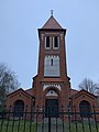
Church of the Holy Family
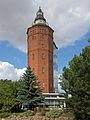
Water tower

Sculpture "rubble woman"

Straw clock in the local history museum

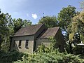
Church in Gehren
Church in Schwarzensee
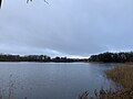
City lake


.JPG)


traffic
The city is located on the federal highway 104 from Neubrandenburg to Stettin and on the state road L 282 to Friedland . The federal autobahn 20 ( Rostock - Kreuz Uckermark ) leads north past Strasburg. The Strasburg (Uckermark) junction is four kilometers from the city center .
Strasburg (Uckerm) train station is on the Bützow – Stettin railway line . It is the stop of the regional express line RE 4 ( Lübeck - Szczecin Główny ) of the Deutsche Bahn AG . It used to be the first Prussian train station on the route from the west. The railway lines to Neustrelitz (dismantled in 1947) and Prenzlau (closed in 1995) also went from here.
Personalities
sons and daughters of the town
- Albert Friedrich Berner (1818–1907), criminal law scholar
- Carl Fürstner (1848–1906), neurologist
- Gerhard Barg (1858–1926), shipyard director
- Ernst Trampe (1860–1915), writer
- Wilhelm Repschläger (1870–1945), politician (KPD)
- Hanns Meinke (1884–1974), poet
- Gerd-Paul von Below (1892–1953), major general in the Wehrmacht
- Otto Naumann (1896–1973), politician (KPD / SED), mayor of the city
- Fritz Micheel (1900–1982), chemist
- Hans Tesch (1918–1980), writer
- Hans Joachim Nauschütz (1940–2003), writer
- Ramona Kapheim (* 1958), rower
- Bernd Walter (* 1962), television presenter
Personalities associated with Strasburg
- Lonny Neumann (* 1934), writer, grew up in Strasburg
- Heinz Kindermann (* 1942), politician (SPD), veterinarian in Strasburg
literature
- Lieselott Enders : Historical local lexicon for Brandenburg, Part VIII, Uckermark , Weimar 1986, ISBN 3-7400-0042-2 .
- Lieselott Enders: The Uckermark - History of a Kurmärkischen landscape from the 12th to the 18th century . Verlag Hermann Böhlaus Nachf., Weimar 1992, ISBN 3-7400-0805-9 .
- Werner Lippert: History of the city of Strasburg in the Uckermark . Ed .: Norbert Raulin, Schibri-Verlag, Milow 2004, ISBN 3-928878-50-6 .
- Erwin Schulz: Chronicle of the city of Strasburg (Uckermark) . Ed .: Norbert Raulin, Schibri-Verlag, Milow 2015, ISBN 3-933978-33-5 .
Web links
Individual evidence
- ↑ Statistisches Amt MV - population status of the districts, offices and municipalities 2019 (XLS file) (official population figures in the update of the 2011 census) ( help ).
- ↑ Regional Planning Association for Western Pomerania. Accessed December 16, 2019 (German).
- ^ Main statute of the city of Strasburg (Um.) , § 12
- ^ Huguenots in Strasburg , website of the city of Strasburg, accessed on January 8, 2020.
- ↑ Strasburg / Uckermark (Mecklenburg-Western Pomerania) , Klaus-Dieter Alicke's website, accessed on January 8, 2020.
- ↑ Information board "Elementary School." - "Red School.", On the building, December 2019.
- ↑ StBA: Changes in the municipalities of Germany, see 1995
- ↑ Population development of the districts and municipalities in Mecklenburg-Western Pomerania (Statistical Report AI of the Statistical Office Mecklenburg-Western Pomerania)
- ^ Result of the local elections on May 25, 2014
- ^ Result of the local election on May 26, 2019
- ↑ Karina Dörk has big plans. In: Nordkurier , April 14, 2015.
- ^ Main statute of the city of Strasburg (Um.) , § 7
- ^ Result of the mayoral election on October 21, 2018
- ↑ Hans-Heinz Schütt: On shield and flag. Tinus Medien, Schwerin 2011, ISBN 978-3981438000 , p. 417/418.
- ↑ a b Main Statute of the City of Strasburg (Um.) , § 1
- ↑ Ernst Trampe on www.zeitstimmen.de
Districts: Gehren | Neuensund | Schwarzensee
Local areas: Boldshof | Ramparts | Glantzhof | Karlsburg | Karlsfelde | Klepelshagen | Köhnshof | Lauenhagen | Linchenshöh | Ludwigsthal | Luisenburg | Louisfelde | Marienfelde | Muchowshof | Ottilienau | Ravensmühle | Schneidershof | Schönburg | Rosenthal | Schwarzensee settlement | Wilhelmsburg | Wilhelmslust | Ziegelhausen | Carpenter's mill
Ahlbeck | Old Tellin | Altwarp | Altwigshagen | Anklam | Bandelin | Bargischow | Behrenhoff | Bentzin | Benz | Mountain wood | Blankensee | Blesewitz | Boldekow | Boock | Brietzig | Brünzow | Bugewitz | Buggenhagen | Butzow | Daberkow | Dargelin | Dargen | Dersekow | Ducherow | Eggesin | Fahrwalde | Ferdinandshof | Garz | Glazov | Görmin | Grambin | Grambov | Greifswald | Gribow | Gross Kiesow | Groß Luckow | Great Polzin | Gützkow | Hammer ad Uecker | Hanshagen | Heinrichswalde | Heringsdorf | Hinrichshagen | Hintersee | Iven | Jarmen | Jatznick | Comb teeth | Karlsburg | Karlshagen | Katzow | Kemnitz | Klein Bünzow | Koblentz | Korswandt | Koserow | Krackow | Krien | Kröslin | Kruckow | Krugsdorf | Krummin | Krusenfelde | Lassan | Leopoldshagen | Levenhagen | Liepgarten | Löcknitz | Loddin | Loissin | Loitz | Lubmin | Luebs | Luckow | Luetow | Medow | Meiersberg | Mellenthin | Mesekenhagen | Mölschow | Mönkebude | Murchin | Nadrensee | Neetzow-Liepen | New Boltenhagen | New Kosenow | Neuenkirchen | Neuenkirchen | Low | Papendorf | Pasewalk | Peenemünde | Penkun | Plow | Polzow | Postlow | Pudagla | Ramin | Rankwitz | Rollwitz | Rossin | Rossow | Rothemühl | Rothenklempenow | Rubenov | Rubkov | Sarnow | Sassen-Trantow | Sauzin | Schmatzin | Schönwalde | Spantekow | Stumble on the Peene | Stolpe on Usedom | Strasburg (Uckermark) | Torgelow | Trassenheide | Tutow | Ückeritz | Ueckermünde | Usedom | Square | Vogelsang-Warsin | Völschow | Wackerow | Weitenhagen | Wilhelmsburg | Wolgast | Wrangelsburg | Wusterhusen | Zemitz | Zempin | Zerrenthin | Ziethen | Zinnowitz | Zirchow | Züssow