
Brodnica
| Brodnica | |||
|---|---|---|---|

|
|
||
| Basic data | |||
| State : | Poland | ||
| Voivodeship : | Kuyavian Pomeranian | ||
| Powiat : | Brodnica | ||
| Area : | 22.87 km² | ||
| Geographic location : | 53 ° 15 ′ N , 19 ° 24 ′ E | ||
| Height : | 95 m npm | ||
| Residents : | 28,788 (Jun. 30, 2019) |
||
| Postal code : | 87-300 to 87-302 | ||
| Telephone code : | (+48) 56 | ||
| License plate : | CBR | ||
| Economy and Transport | |||
| Street : | Toruń - Bydgoszcz | ||
| Rail route : | Brodnica – Jabłonowo Pomorskie | ||
| Next international airport : | Bydgoszcz | ||
| Gmina | |||
| Gminatype: | Borough | ||
| Surface: | 22.87 km² | ||
| Residents: | 28,788 (Jun. 30, 2019) |
||
| Population density : | 1259 inhabitants / km² | ||
| Community number ( GUS ): | 0402011 | ||
| Administration (as of 2010) | |||
| Mayor : | Jarosław Radacz | ||
| Address: | ul.Kamionka 23 87-300 Brodnica |
||
| Website : | www.brodnica.pl | ||

Brodnica ([ brɔdˈɲiʦa ], German Strasburg in West Prussia or Strasburg an der Drewenz ) is a city in the Polish Kujawien-Pomeranian Voivodeship .
Geographical location
The city is located in the former West Prussia on the Drewenz , south of the Danzig Bay and south of Marienwerder ( Kwidzyn ), about 45 kilometers (as the crow flies) southeast of Graudenz ( Grudziądz ).
history


Strasburg 1738–1745 ( Georg Friedrich Steiner )
|

Strasburg was first mentioned in 1262 as Strasberg . The Teutonic Order planned to secure itself against incursions by the pagan Prussians and Lithuanians by building a fortified settlement at an important crossing over the Drewenz , its former eastern border . The place was first mentioned as a city in 1298 during a Lithuanian raid .
With the Second Peace of Thorner in 1466, the city came as part of the Kulmerland to the autonomous Prussian royal share under Polish patronage . From then on, the Kulmerland was exposed to attempts at polonization , with the main goal of converting the autonomous region of Prussia, a royal part, into a Polish province. On the occasion of the formation of the Union of Lublin , through which the dual state Poland-Lithuania emerged, King Sigismund II. August unilaterally terminated the autonomy of Royal Prussia with his decree of March 16, 1569 at the Lublin Sejm under threat of severe penalties, which is why the sovereignty of the Polish king was perceived as foreign rule by the former cities of the Prussian Confederation from 1569 to 1772. During the Polish rule, the Kulmer Land and Michelauer Land were almost completely Polonized: during the first Polish partition in 1772, the only purely German districts found here were Thorn and the Thorn-Kulmer Lowlands. This was also due to the fact that the originally German nobility rapidly Polonized due to privileges they had received.
As part of the first partition of Poland , Strasburg came to the Kingdom of Prussia in 1772 . During the French period in 1807 Strasburg was temporarily part of the Duchy of Warsaw . After the Congress of Vienna in 1815, it reverted to Prussia. From 1818, Strasburg was the seat of the District Office of the Strasburg district in West Prussia . At the beginning of the 20th century Strasburg had a Protestant church, a Catholic church, a synagogue , a grammar school, a district court, a main customs office and several commercial operations.
After the First World War , Strasburg had to be ceded to Poland in 1920 due to the provisions of the Versailles Treaty for the purpose of establishing the Polish Corridor . The place name Brodnica was introduced. In 1934, the Polish state government unilaterally terminated the minority protection treaty concluded in Versailles on June 28, 1919 between the Allied and Associated Main Powers and Poland . After the invasion of Poland in 1939, the district was annexed by the German Reich and assigned to the Reichsgau Danzig-West Prussia , to which Strasburg belonged until 1945. The city's synagogue was destroyed in 1939.
Towards the end of World War II , Strasburg was occupied on January 22, 1945 by the Red Army advancing west . Around 1,000 residents of the city lost their lives by the end of the war. As far as German townspeople had not fled, they were in the aftermath of Strasburg sold .
Demographics
| year | Residents | Remarks |
|---|---|---|
| 1772 | 1,283 | in 228 households ( fireplaces ) |
| 1783 | 1,853 | with the garrison (315 people belonging to two squadrons of a hussar regiment formed in 1773 ), mostly Lutherans , 27 Jews |
| 1802 | 1,768 | |
| 1807 | 2.113 | |
| 1816 | 1.994 | including 713 Protestants, 1,131 Catholics and 150 Jews |
| 1821 | 2,356 | |
| 1826 | 2,669 | |
| 1831 | 2,585 | mostly German |
| 1852 | 3,959 | |
| 1864 | 5,014 | including 2,739 Evangelicals and 2,275 Catholics |
| 1871 | 5,305 | including 2,700 Evangelicals and 2,300 Catholics (2,000 Poles ) |
| 1875 | 5,454 | |
| 1880 | 5,801 | |
| 1890 | 6.122 | of which 2,587 Protestants, 3,048 Catholics and 480 Jews (2,000 Poles) |
| 1905 | 7,217 | with the garrison (3rd Battalion of Infantry Regiment No. 141 ), including 2,702 Evangelicals and 318 Jews |
| 1910 | 7,951 | |
| 1931 | 8,521 | about 800 Germans |
| year | Residents | Remarks |
|---|---|---|
| 2006 | 32,588 |
Attractions
- St. Catherine's Church, Gothic brick building, built in the 13th and 14th centuries, with interior fittings in the Renaissance and Baroque styles
- Parish Church of the Immaculate Conception of the Blessed Virgin Mary, Baroque building, built from 1752 to 1761, consecrated on August 1, 1762.
- Former Evangelical Church, built from 1827 to 1830 in the classical style, consecrated on April 4, 1830. The parish belonged to the Old Prussian Church Province of West Prussia until 1923 and to the Old Prussian Church District of Danzig-West Prussia from 1940 to 1945, in between (1923-1940) to the Uniate Evangelical Church in Poland . Last Protestant service on January 1, 1945. After the Second World War, taken over by the Catholic Church, today a church school
- From the Teutonic Order's castle, which was built in the first half of the 14th century and demolished after 1785 , the 54-meter-high tower with observation deck, remains of walls and parts of the cellar, in which there is an archaeological exhibition, have been preserved
- From the city fortifications, which were also built in the first half of the 14th century, the Kulmer Gate with a brick Gothic stepped gable (today a gallery for contemporary art) and the stork tower have been preserved in addition to the wall remains
- Anna Wasa Palace, built in 1564, from 1606 to 1625 the residence of the Swedish Princess Anna Wasa (1568–1625), sister of the Polish King Sigismund III. Wasa , reconstructed from 1678 to 1698, burnt out in 1945, after reconstruction from 1960 to 1970 the building is now used as a library
- The town hall, built at the end of the fourteenth century, was destroyed by fire in 1631. It was later surrounded by buildings and finally demolished in 1868 except for the preserved octagonal tower.
- Granary from the 17th century, today the city and regional museum

The old town from the castle tower

Parish Church of St. Catherine

Parish Church of the Immaculate Conception of the Blessed Virgin Mary

Former Evangelical Church, now a school

Market square with town hall tower

Tower of the Castle of the Teutonic Order

Kulmer Gate

Stork Tower (Wieża Mazurska)

Medieval city wall
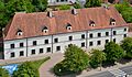
Anna Wasa Palace

Museum, former granary

Neoclassical town hall, seat of the magistrate (city administration)


traffic
Brodnica is located on the national road 15 in the direction of Ostróda and has an important train station in the past. In terms of passenger traffic, however, only the Działdowo – Chojnice railway westwards, towards Jabłonowo Pomorskie and Grudziądz, is served, while eastwards, as well as the lines to Kowalewo Pomorskie and the Tama Brodzka – Iława railway line, no longer operates. The route from Sierpc is only served by freight traffic.
There is a regular long-distance bus route with Germany.

Rural municipality of Brodnica
The rural municipality of Brodnica, to which the city of Brodnica itself does not belong, has an area of 126.96 km², on which 8445 people live (June 30, 2019).
Town twinning
There are partnerships with the following cities;
- Strasburg (Uckermark) , Germany
- Brørup Municipality , Denmark
- Kėdainiai , Lithuania
- Kristinehamn , Sweden
sons and daughters of the town
- Paul von Krause (1852–1923), lawyer and politician
- Robert Garrison (1872–1930), character actor
- Sammy Gronemann (1875–1952), writer, journalist and lawyer
- Rudolf home (1877–1961), painter
- Heinz von Hennig (1883–1947), Rear Admiral of the Reichsmarine, b. at the Dembrowalonka estate of the city of Strasburg
- Kurt Blavier (1886–1938), Senator of the Free City of Danzig and Nazi victim
- Emil Just (1885–1947), German major general
- Artur Marya Swinarski (1900–1965), playwright and poet
- Walter Albath (1904–1989), lawyer, SS leader and Gestapo official
- Rolf Böger (1908–1995), lawyer and member of the Bundestag
- Klaus Weissermel (1922–1997), chemist
- Henryk Strzelecki (1925–2012), founder of the fashion brand "Henri Lloyd"
- Edward Zielski (* 1945), Catholic clergyman, Bishop of São Raimundo Nonato in Brazil
- Ewa Kierzkowska (* 1964), politician
- Waldemar Chełkowski (* 1975), racing driver
- Daniel Trojanowski (* 1982), rower and Olympic participant
- Maciej Hreniak (* 1989), swimmer
literature
- Johann Friedrich Goldbeck : Complete topography of the Kingdom of Prussia . Part II: Topography of West Prussia , Marienwerder 1789, pp. 42–44.
- August Eduard Preuss : Prussian country and folklore . Königsberg 1835, pp. 437–438, no. 46.
- Ernst Bahr: Strasburg. In: Handbook of historical sites , East and West Prussia . Kröner, Stuttgart 1981, ISBN 3-520-31701-X , pp. 215-216.
- Friedrich August Zermann: Chronicle of the city of Strasburg in West Prussia. From the earliest times, where the historical sources reach, to the present . Strasburg 1851. (full text)
- Isaac Gottfried Gödtke : Church history of the city of Strasbourg. In: Archives for patriotic interests. New series, year 1845, Marienwerder 1845. pp. 689–712.
- Rudolf Birkholz: The Strasburg district . Osnabrück 1981, DNB 208967605 .
- Rudolf Birkholz: 700 years of Strasburg . Brodnica 1989, ISBN 83-905158-4-9 .
Web links
Footnotes
- ↑ a b population. Size and Structure by Territorial Division. As of June 30, 2019. Główny Urząd Statystyczny (GUS) (PDF files; 0.99 MiB), accessed December 24, 2019 .
- ↑ Hans Plehn, History of the Strasburg District in West Prussia (Leipzig 1900) p. 32 f.
- ^ A b Hans Prutz : History of the Neustadt district in West Prussia . Danzig 1872, p. 104 .
- ^ A. Reusch: West Prussia under Polish scepter. Ceremonial speech given at the Elbinger Gymnasium on 13th Spt. 1872 . In: Altpreußieche Monatsschrift , NF, Volume 10, Königsberg 1873, pp. 140–154, especially p. 146 .
- ^ Friedrich Wilhelm Ferdinand Schmitt : Land and people in West Prussia . In: Journal for Prussian History and Regional Studies . Volume 7, Berlin 1870, pp. 189-229, especially pp. 192-193.
- ↑ Xaver Frölich : History of the Graudenzer Kreis . Volume 1, Graudenz 1868, p. 103.
- ^ Bernhard von Winckler : West Prussian Studies . In: Old Prussian Monthly Journal , Volume 3, Königsberg 1866, pp. 415–440 .
- ↑ a b Meyer's Large Conversation Lexicon. 6th edition. Volume 19, Leipzig / Vienna 1909, pp. 95–96.
- ↑ a b c Handbook of historical sites , East and West Prussia , Kröner, Stuttgart 1981, ISBN 3-520-31701-X , pp. 215-216.
- ^ Johann Friedrich Goldbeck : Complete topography of the Kingdom of Prussia . Part II: Topography of West Prussia , Marienwerder 1789, pp. 42–44.
- ↑ a b c Alexander August Mützell and Leopold Krug : New topographical-statistical-geographical dictionary of the Prussian state . Volume 5: T – Z , Halle 1823, pp. 386–387, item 713.
- ^ August Eduard Preuss: Prussian country and folklore . Königsberg 1835, p. 437, no. 46.
- ^ Kraatz: Topographical-statistical manual of the Prussian state . Berlin 1856, p. 359.
- ^ E. Jacobson: Topographical-statistical handbook for the administrative district Marienwerder , Danzig 1868, pp. 190–191, no. 291 .
- ^ Gustav Neumann: Geography of the Prussian State . 2nd edition, Volume 2, Berlin 1874, pp. 50–51, item 5.
- ^ A b c Michael Rademacher: German administrative history of the province of West Prussia, Strasburg district . 2006.
- ↑ The Big Brockhaus. 15th edition. Volume 18, Leipzig 1934, p. 234.
- ↑ http://www.zamkipolskie.com/brodnica/brodnica.html Castle of the Teutonic Order