Grudziądz
| Grudziądz | ||
|---|---|---|

|
|
|
| Basic data | ||
| State : | Poland | |
| Voivodeship : | Kuyavian Pomeranian | |
| Powiat : | District-free city | |
| Area : | 59.00 km² | |
| Geographic location : | 53 ° 29 ′ N , 18 ° 46 ′ E | |
| Height : | 50 m npm | |
| Residents : | 94,732 (Jun. 30, 2019) |
|
| Postal code : | 86-300 to 86-311 | |
| Telephone code : | (+48) 56 | |
| License plate : | CG | |
| Economy and Transport | ||
| Street : | Bromberg ( Bydgoszcz ) - Olsztyn ( Olsztyn ) Gdansk - Torun ( Toruń ) |
|
| Rail route : | Toruń – Malbork | |
| Jabłonowo Pomorskie – Laskowice Pomorskie | ||
| Next international airport : | Bydgoszcz (Bromberg) | |
| Gmina | ||
| Gminatype: | Borough | |
| Surface: | 59.00 km² | |
| Residents: | 94,732 (Jun. 30, 2019) |
|
| Population density : | 1606 inhabitants / km² | |
| Community number ( GUS ): | 0462011 | |
| Administration (as of 2018) | ||
| City President : | Maciej Glamowski | |
| Address: | ul.Ratuszowa 1 86-300 Grudziądz |
|
| Website : | www.grudziadz.pl | |
Grudziądz ( [ ˈgruʥɔnts ] , German Graudenz ) is a city in the Polish Kuyavian-Pomeranian Voivodeship with almost 96,000 inhabitants. It is independent of a circle and the seat of an eponymous Gmina and the powiat Grudziądzki .
geography
location
The city is located in the former West Prussia , on the east bank of the Vistula , about 22 kilometers northeast of Świecie (Schwetz) , 93 kilometers south of Gdansk and 170 kilometers southwest of Kaliningrad (Königsberg) .
Districts
| Polish name | German name until 1920 |
German name (1939-1945) |
|---|---|---|
| Kawalerii Polskiej | Cavalry barracks | Cavalry barracks |
| Copernica | - | - |
| Lotnisko | Rehdorf | Rehdorf |
| Mały Kuntersztyn | Klein Kunterstein | Kleinkunterstein |
| Mniszek | Mischke | Mischke |
| Owczarki | Wossarken | Wossarken |
| Pastwisko | Old willow | Old willow |
| Rudnik | Rudnick |
1939–1942 Rudnick 1942–1945 Rudorf |
| Rządz | Rondsen | Ronsee |
| Sadowo | Schadau | Schadau |
| Śródmieście | City center | City center |
| Strzemięcin | Stremoczyn 1891–1920 Böslershöhe |
Böslershöhe |
| Tarpno | Small tarps | Kleintarpen |
| Tuszewo | Fake | Fake |
| Twierdza | Festival of Graudenz 1893–1920 Festival of Courbière |
Festivities Courbière |
| Wielki Kuntersztyn | Great Kunterstein | Großkunterstein |
| Wyzwolenia | - | - |
history
Former fortress of the Pruzzen on the border with Poland
Traces of settlement date from the 10th century. The German place name Grudziadz derives from pruzzisch Graude, Grauden, Gray Denes on what forest wilderness means. Graudenz is located in the Grauden forest and was first a fortified place of the Pruzzen against the conquest of Polish rulers. In 1080 (according to Goldbeck in 1060) Boleslaw was successfully repelled near Grauden (z). In 1222 certified Konrad , Duke in Mazovia and Cujavia that he the first Bishop of Prussia, Christian , for allowing us which of these the particular to Prussia Crusaders to rebuild the castle Culmen ( Kulm left), a part of the Chelmno country have awarded , including the former Grudenz Castle and the Gruth ( Grutta ) forest east of Burgplatz .
city
Graudenz belonged to the Kulmer Land , which Konrad von Masowien offered the Teutonic Order in 1225/26 in exchange for the fight against the Pruzzen and ceded it to them in 1230 through the Treaty of Kruschwitz .
From the castle and commandery of the Teutonic Order, built in 1231, only remnants of the walls are preserved today. In 1291 Graudenz was granted city rights ( Kulmer Handfeste ) and was surrounded with city walls in the following years. The city experienced its first heyday and developed into a center of the grain trade in the 14th century. The composer Petrus Wilhelmi de Grudencz (1400–1480) became known from Graudenz .
The Kulmer Land was united in the Prussian Confederation , and as a result of this the Teutonic Order had to submit the Kulmer Land to the patronage of the Crown of Poland in the Second Peace of Thorne in 1466 . Due to its favorable geographical location, Kulm developed into the seat of the state parliament of Polish Prussia , as well as the estates and general assemblies took place here. In 1522 , Nikolaus Kopernikus gave a lecture on coinage at a Prussian meeting of the estates . In the 16th century Graudenz developed into a center of handicrafts and trade, but was thrown back by the wars of the 17th century. During the Second Northern War , the city was captured by the Swedes in 1655 and recaptured by Polish troops in 1659, where it was almost completely destroyed. Despite the continuing wars and internal conflicts, Graudenz was magnificently rebuilt in the baroque style ("Graudenzer Barock").
Through the first partition of Poland , Graudenz came under Frederick II of Prussia to the Kingdom of Prussia in 1772 . Frederick II had a large fortress built here, which was later expanded (see below). Graudenz was part of the province of West Prussia and a district town in the Marienwerder administrative district . After the construction of the railway line from Thorn to Marienburg , the construction of a bridge over the Vistula and the completion of a west-east connection through the Konitz – Soldau railway line , the city developed into a rapidly growing industrial location in the 19th century. a. with iron foundries, mechanical engineering, car manufacturing and textile industry. Between 1880 and 1905 the population doubled from 17,321 to 35,958. In 1900 Graudenz became an independent city.
Since the middle of the 19th century, Graudenz had had a secondary school where Latin was a compulsory subject. At the beginning of the 20th century there was a grammar school, an upper secondary school, a Catholic school teacher seminar, a preparation institute, a museum, a penitentiary, an iron foundry, a machine factory and various production facilities for the consumer industry in Graudenz. For rail traffic, Graudenz was the junction of the state railway lines Kulmsee – Marienburg and Neustettin – Goßlershausen. The city was the seat of a local court and a regional court. An electric tram was available for traffic in the city. In the city there were two Protestant churches and three Catholic churches, two of which were garrison churches, and a synagogue.
Up to and including 1919, Graudenz was part of the Marienwerder administrative district in the West Prussia province of the German Empire .
After the First World War , Graudenz (around 40,300 inhabitants in 1910) had to be ceded to Poland in January 1920 due to the provisions of the Versailles Treaty establishing the Polish Corridor in Pomerellen , without a referendum and despite a German majority (84% in the city, 58% in the district Graudenz). A Polish military base with a cavalry training center was set up in Graudenz . With the invasion of Poland in 1939, the area of the Polish Corridor came under the German Empire in violation of international law . On October 26, 1939, Graudenz was incorporated as part of the Marienwerder administrative district into the new province of Reichsgau Danzig-West Prussia , to which the city belonged until 1945. From September 1939 to August 1943 there was a men's and a women's satellite camp of the Stutthof concentration camp in Graudenz .
Towards the end of the Second World War , Graudenz was surrounded by the Red Army and then declared a fortress on February 9, 1945. The defenders of about 9,000 men under Lieutenant General Ludwig Fricke (1893–1967) capitulated after heavy fighting on March 6, 1945. In the course of the fighting during the siege, about 60% of the city was destroyed. The city became part of Poland again after the war. After that, the immigration of Polish civilians began. Had not fled far as German citizens, they were in the period that followed largely driven .
Graudenz fortress

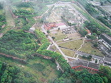
Since the two main fortresses in West Prussia, Danzig and Thorn (Toruń) , remained in Polish possession after the First Partition of Poland , King Friedrich II ordered the construction of a fortress on a hill on the Vistula between Graudenz and Marienwerder. Construction work began in 1774, but had to be abandoned at this location as it was found to be at risk of flooding. Therefore, the location of the fortress was moved to an elevation on the bank of the Vistula approx. 1.5 km north of the city of Graudenz. The work, which began in 1776 in the presence of Frederick II, lasted until 1789. The layout of the fortress, which was based on the Vistula, was half an octagon in shape. In addition to the actual fortifications, there were external works that served to protect the main works, e.g. B. the "Hornwerk", a fortification that secured access from the north.
The fortress was besieged only once, during the Napoleonic Wars . From January to December 1807 the garrison under General Wilhelm de Courbière successfully defended itself against French troops, while most of the other Prussian fortresses surrendered. The siege was formally ended on July 9, 1807 with the signing of the Tilsit Peace, but lasted until December of the same year. After his death in 1811, Courbière was buried on the fortress grounds. After the end of the war, further expansions and a. around the so-called Courbière-Schanze on the opposite left bank of the Vistula. In 1872 the fortress was temporarily disarmed, but it remained a garrison and military training area. The construction of the Vistula Bridge at Graudenz in 1885/1886 increased its strategic importance, which is why the fortress was modernized and surrounded from 1889 to 1905 with a new ring of fortifications made of forts and armored artillery shelters. Since 1893 it was called "Feste Courbière". The decision made in 1913 to further expand the fortress was only rudimentarily implemented due to the outbreak of the First World War .
In the 19th century the fortress also served as a prison, and a. Polish independence fighters were imprisoned. An incident in 1862 caused a sensation in which soldiers of Polish descent refused to give a military salute in protest against harassment and mistreatment, for which harsh sentences of up to 20 years in prison were imposed. During the First World War it served as a prisoner-of-war camp for officers of the Entente . After the Treaty of Versailles came into force in 1920, the Polish army took over the fortress, which they owned until 1939. Considerations to dismiss her for the employment of the unemployed were not implemented, instead she became a garrison of a Polish cavalry regiment.
The fortifications played no significant role in the Second World War and were taken by the German Wehrmacht without much effort. After that, they were again used as a depot, for maneuvers and as a prison. An execution site was built in the fortifications on the Pfaffenberg (Księże Góry). When the Red Army attacked the city in early 1945, some of the old fortifications still proved to be serious obstacles to conquering the city. After the defenders surrendered on March 6, 1945, the course of which Lev Kopelev describes in his book "Keeping for All Time", German prisoners of war were now housed in the fort. After that, the fortifications stood empty for years until they were again taken over by the Polish army. Although parts of the fortress were filled in, removed or severely disintegrated, Graudenz is still an important example of European fortress architecture of the 18th and 19th centuries. The fortress can be partially visited.
Demographics
| year | population | Remarks |
|---|---|---|
| 1780 | 3675 | including suburbs and the garrison (241 people). "The inhabitants (...) are almost all (...) of Protestant religion and Germans" |
| 1804 | 3874 | of which ( 1805 ) 2,240 Evangelicals and 1,206 Catholics |
| 1816 | 5118 | |
| 1831 | 4846 | |
| 1837 | 5918 | |
| 1852 | 10,885 | |
| 1864 | 10,567 | without the fortress (223 people), of which 6307 Protestants and 3670 Catholics |
| 1871 | 15,559 | of which 9,000 Protestants and 6,000 Catholics (170 Poles ) |
| 1875 | 14,522 | |
| 1880 | 17,321 | |
| 1885 | 17,336 | |
| 1890 | 20,385 | thereof 13,171 Protestants, 6152 Catholics, 810 Jews and 252 others (150 Poles) |
| 1900 | 32,727 | with the garrison (two infantry regiments No. 129 and No. 175, two divisions of field artillery No. 35 and No. 71, a battalion of foot artillery No. 15 and two squadrons of hunters on horseback), of which 10,415 Catholics and 816 Jews |
| 1905 | 35,958 | |
| 1910 | 40,325 | thereof 33,496 Germans, 5034 Poles and nine Kashubians . (25,493 Protestants, 13,612 Catholics and 1,220 others including Jews) |
| year | Residents | Remarks |
|---|---|---|
| 1921 | 33,520 | thereof 6,940 Germans |
| 1943 | 55,336 | |
| 1980 | 90,000 | |
| 1990 | 102,300 | |
| 2000 | 100,787 | |
| 2010 | 96,042 |
Attractions
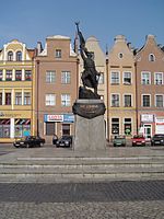
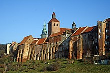
The city is known for its beautiful scenic location and its lovely old town with the old storehouses on the Vistula.
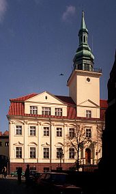
Sights are: market square, parish church of St. Mikołaj, Jesuit church and monastery, granary, water gate, Benedictine monastery, fortress, town hall with ballroom, main post office, Rudniksee, Tarpno, city park, Trynka canal and the planetarium.
traffic
In the station Grudziądz meets the railway line Działdowo-Chojnice to the railway Toruń-Malbork .
In the city the passenger traffic is carried out with numerous bus lines as well as a tram line.
It is located on state roads 16 and 55 .
Gmina Grudziądz
The independent city is also the seat of a Gmina , which connects to the urban area in the south, east and north.
politics
City President
At the head of the city administration is the city president . From 2002 to 2018, this was Robert Malinowski ( PO ), who did not run for the regular election in October 2018. The result was as follows:
- Maciej Glamowski (election committee “Citizens' Alliance Grudziądz - Maciej Glamowski”) 46.4% of the vote
- Arkadiusz Baranowski ( Prawo i Sprawiedliwość ) 29.4% of the vote
- Marek Sikora (“Marek Sikora - Grudziądz unites us” electoral committee) 10.5% of the vote
- Zenon Róźycki (Electoral Committee "Zenon Róźycki - Development Forum Grudziądz") 9.8% of the vote
- Joanna Wiśniewska ( Kukiz'15 ) 3.9% of the vote
In the run-off election that was necessary, Glamowski clearly prevailed against the PiS candidate Baranowski with 60.2% of the vote and became the new city president.
City council
The city council has 23 members who are directly elected. The election in October 2018 led to the following result:
- Koalicja Obywatelska (KO) 29.6% of the vote, 8 seats
- Prawo i Sprawiedliwość (PiS) 27.8% of the vote, 8 seats
- Election committee "Citizens' Alliance Grudziądz - Maciej Glamowski" 26.6% of the vote, 7 seats
- Election committee "Zenon Róźycki - Grudziądz Development Forum" 7.5% of the vote, no seat
- Electoral committee “Marek Sikora - Grudziądz unites us” 5.1% of the vote, no seat
- Kukiz'15 3.3% of the vote, no seat
Twin cities

Personalities
sons and daughters of the town
- Petrus Wilhelmi de Grudencz (1392 – around 1480), composer and poet
- Johann Stobäus (1580–1646), composer
- Georg Vette (1645–1704), pharmacist and member of the " Leopoldina "
- Martin Oloff (1652–1715), Lutheran pastor in the Kingdom of Poland
- Emil Karl Friedrich Meyer (1792–1861), Prussian major general
- Georg Gottfried Kallenbach (1805–1865), art scholar and architectural historian
- Karl Rudolf von Ollech (1811-1884), general
- Rudolf von Oppeln-Bronikowski (1826–1894), Prussian infantry general, governor of the Metz fortress
- Stanislaus von Leszczynski (1842–1932), Prussian lieutenant general and military writer
- Viktor von Grumbkow (1849–1901), Prussian major general
- Gustav Roethe (1859–1926), philologist
- Gustav von Kortzfleisch (1854–1910), Prussian general
- Hans von Below (1862–1933), Lieutenant General
- Max Wentscher (1862–1942), university professor for philosophy and education
- Alfred Wohl (1863–1939), chemist
- Johannes Gronowski (1874–1958), politician
- Martha Harpf (1874–1942), businesswoman and politician
- Erich Hossenfelder (1875–1935), envoy to Ethiopia
- Ernst Hardt (1876–1947), writer
- Erich Basarke (1878–1941), architect
- Käthe Gaebel (1879–1962), national economist and career advisor
- Waldemar Kophamel (1880–1934), submarine commander
- Leo White (1882–1948), German-American actor (including in Chaplin films)
- Percy Brigl (1885–1945), agricultural chemist and university professor in Tübingen and Hohenheim
- Gerhard Witting (1889–1982), opera singer
- Paul Kalinowski (1893–1968), politician (CDU), member of the state parliament in Rhineland-Palatinate
- Hermann Ulrich Albrecht (1897–1995), radiologist and radiation therapist
- Ernst Krüger (1898–1995), film producer and association official
- Hermann Roloff (1900–1972), architect and spatial planner
- Herbert Wentscher (1900–1994), painter, art teacher and teacher
- Kurt Weyher (1901–1991), naval officer, rear admiral in World War II
- Bruno Czarnowski (1902 - unknown, after 1938), politician (NSDAP)
- Erwin Levy (1907-1991), psychologist
- Horst Neumann-Duesberg (1907–1990), lawyer and university professor, inventor of the legal figure of the “relative person of contemporary history” as the “key fossil” of press law and data protection law
- Karl Halaski (1908–1996), reformed clergyman
- Hans Karl Fritzsche (1914–1999), officer and ministerial official, Stauffenberg's confidante
- Herbert Grasemann (1917–1983), chess composer and writer
- Heinz Ernst Gumrich (1917–1984), physician, inventor of a ring probe
- Ilse Krause (1917–1984), Germany's first female pediatric surgeon and university professor
- Henryk Czyż (1923–2003), composer, conductor and music teacher
- Waldemar Baszanowski (1935–2011), weightlifter
- Stefania Toczyska (* 1943), opera singer
- Uwe Holtz (* 1944), German political scientist
- Piotr Kiełpikowski (* 1962), fencer
- Lydia Pockaj (* 1980), German singer
- Łukasz Kwiatkowski (1982–2018), track cyclist
- Rafał Sarnecki (* 1990), track cyclist
Personalities associated with the city
- Nikolaus Heinrich von Pirch (1736–1808), commandant of Graudenz
- Hermann Haase (1814–1871), patrimonial judge in German Eylau, mayor of Graudenz (1844 ff.)
- Bernhard Stadié (1833–1895), pastor of Graudenz, West Prussia historian
Honorary citizen
- Xaver Frölich (1822–1898), city archivist and local historian.
Trivia
Based on studies by the historical faculty of the University of Gdańsk , a computer game was published in 2020 that deals with the development of water management in Grudziądz since the Middle Ages.
literature
- in order of appearance
- Johann Friedrich Goldbeck : Complete topography of the Kingdom of Prussia . Part II: Topography of West Prussia. Marienwerder 1789, pp. 28-30, no. 1.) .
- August Eduard Preuss : Prussian country and folklore . Königsberg 1835, pp. 419-422, no. 33 .
- Xaver Frölich : The witch trials in Graudenz. In: New Prussian Provincial Papers. Third episode. Volume 10, Königsberg 1863, pp. 104-124.
- Xaver Frölich: Bourgeois life in Graudenz during the first half of the 17th century. In: New Prussian Provincial Papers. Fourth episode. Volume 5, Königsberg 1868, pp. 1-47.
- Xaver Frölich: History of the Graudenzer Kreis . Volume 1, Graudenz 1868, pp. 84–156.
- Xaver Frölich: The oldest Schöppenbuch in the Graudenzer Archive. In: New Prussian Provincial Papers. Fourth episode. Volume 8, Königsberg i. Pr. 1871, pp. 427-450.
- Xaver Frölich: Names and origins of the foreigners who became residents of Graudenz in the years 1606–1773 . In: New Prussian Provincial Papers. Fourth episode, volume 12, Königsberg i. Pr. 1875, pp. 542-547.
- Erich Weise (Hrsg.): Handbook of historical places . Volume: East and West Prussia (= Kröner's pocket edition . Volume 317). Unchanged reprint of the 1st edition 1966. Kröner, Stuttgart 1981, ISBN 3-520-31701-X , pp. 71–73.
- Jürgen W. Schmidt: Theater and nationality struggle in the province of West Prussia: The project of a national theater in Graudenz 1905-1911. In: West Prussia yearbook. Volume 60, Münster 2010, pp. 139–150.
- Hans Jacobi: The excavation results of the Teutonic castles of Graudenz and Roggenhausen: a contribution to the architectural development of the castles of the order. Edited and provided with an afterword by Udo Arnold , Deutsche Burgenvereinigung eV (= publications from the project area East German State History. Issue 12; Deutsche Burgenvereinigung eV for the preservation of historical defense and residential buildings: publications of the German Castle Association. Series A: Research. Volume 3) . Deutsche Bürgerervereining , Braubach 1996, ISBN 3-927558-02-8 (Dissertation University of Danzing 1943, 150 pages).
- Wiesław Sieradzan: The city maps of Graudenz from the 17th to 20th centuries Century. Perspectives on the publication of a historical atlas. In: Contributions to the history of West Prussia. 14, 1995, pp. 55-68.
- Horst-Dieter von Enzberg: The Goetheschule in Graudenz and the German-Polish relationship (1920-1945) (= contributions to school history. Volume 5). Institut Nordostdeutsches Kulturwerk Lüneburg, Lüneburg 1994, ISBN 3-922296-74-2 (dissertation FU Berlin 1992, 853 pages).
- Nordewin from Diest-Koerber u. a .: The city and the district of Graudenz - from seven centuries of German history. Cologne-Porz 1976.
- Siegfried Anger: The grave field to Rondsen in the district of Graudenz. Graudenz 1890. ( digitized in the digital library Mecklenburg-Western Pomerania)
- Lesław Domowicz: Cytadela Grudziądzka. Vector, 2006, http://www.vector.biz.pl/
Web links
- Official website of the city of Grudziądz (Polish, German, English)
- Current pictures from Graudenz / Grudziądz and short story as the foundation of the Teutonic Order
- Graudenz . In: Meyers Konversations-Lexikon . 4th edition. Volume 7, Verlag des Bibliographisches Institut, Leipzig / Vienna 1885–1892, p. 638.
- Graudenz: Church register, films, baptisms, marriages, deaths since 1622 at LDS
Individual evidence
- ↑ a b population. Size and Structure by Territorial Division. As of June 30, 2019. Główny Urząd Statystyczny (GUS) (PDF files; 0.99 MiB), accessed December 24, 2019 .
- ↑ Friedrich August Voßberg : History of the Prussian coins and seals from the earliest times to the end of the rule of the Teutonic Order . Berlin 1843, pp. 36-37.
- ^ A b Johann Friedrich Goldbeck : Complete topography of the Kingdom of Prussia . Part II, Marienwerder 1789, p. 28, No. 1.)
- ↑ Max Perlbach : Prussian Regesta until the end of the 13th century. In: Old Prussian monthly. Volume 11, Königsberg i. Pr. 1874, pp. 1-32, especially p. 18.
- ^ L. Wiese: The higher school system in Prussia. Historical-statistical representation. Berlin 1864, pp. 77-78.
- ↑ a b c Meyer's Large Conversation Lexicon. 6th edition. Volume 8, Leipzig / Vienna 1907, p. 251.
- ↑ Subcamps 1187 and 1188 of the Stutthof concentration camp (accessed on July 27, 2016).
- ↑ Xaver Frölich : History of the Graudenzer Kreis . Volume 1, Graudenz 1868, p. 138.
- ↑ Alexander August Mützell, Leopold Krug : New topographical-statistical-geographical dictionary of the Prussian state . Volume 2: G – Ko , Halle 1821, p. 75.
- ^ August Eduard Preuss: Prussian country and folklore . Königsberg 1835, pp. 419-421, no. 33.
- ↑ a b c Erich Weise (ed.): Handbook of historical sites. Volume: East and West Prussia (= Kröner's pocket edition. Volume 317). Unchanged reprint of the 1st edition 1966. Kröner, Stuttgart 1981, ISBN 3-520-31701-X , pp. 71–73.
- ^ Kraatz: Topographical-statistical manual of the Prussian state . Berlin 1856, p. 200.
- ^ E. Jacobson: Topographical-statistical manual for the administrative district Marienwerder. Danzig 1868, pp. 20-21, no. 57 .
- ^ Gustav Neumann : Geography of the Prussian State. 2nd edition, Volume 2, Berlin 1874, pp. 53-54, item 8.
- ↑ a b c d e Michael Rademacher: German administrative history from the unification of the empire in 1871 to the reunification in 1990. Province of West Prussia, city and district of Graudenz. (Online material for the dissertation, Osnabrück 2006).
- ↑ The Big Brockhaus. 15th edition. Volume 7, Leipzig 1930, p. 685.
- ^ Result on the website of the election commission, accessed on August 13, 2020.
- ^ Result on the website of the election commission, accessed on August 13, 2020.
- ↑ Short biography (s) ( Memento from February 23, 2015 in the Internet Archive )
- ↑ koeblergerhard.de
- ↑ https://armorgames.com/waterworks-game/19010


