Grudziądz (rural municipality)
| Gmina Grudziądz | ||
|---|---|---|

|
|
|
| Basic data | ||
| State : | Poland | |
| Voivodeship : | Kuyavian Pomeranian | |
| Powiat : | Grudziądzki | |
| Geographic location : | 53 ° 29 ′ N , 18 ° 46 ′ E | |
| Height : | 50 m npm | |
| Residents : | 12,048 | |
| Gmina | ||
| Gminatype: | Rural community | |
| Gmina structure: | 34 localities | |
| 25 school offices | ||
| Surface: | 165.33 km² | |
| Residents: | 12,812 (Jun. 30, 2019) |
|
| Population density : | 77 inhabitants / km² | |
| Community number ( GUS ): | 0406012 | |
| administration | ||
| Wójt : | Andrzej Henryk Rodziewicz | |
| Address: | ul.Wybickiego 38 86-300 Grudziądz |
|
| Website : | www.grudziadz.ug.gov.pl | |
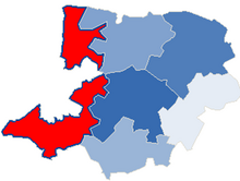
The gmina wiejska Grudziądz is an independent rural municipality in Poland in the powiat Grudziądzki in the Kuyavian-Pomeranian Voivodeship . Its seat is in the independent city of Grudziądz (German Graudenz ).
geography
Geographical location
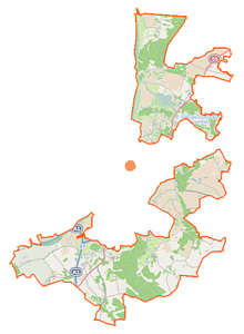
The rural community (Gmina) is located on the east bank of the Vistula and includes the city of Grudziądz in the north, south and east. In the east, however, the city cuts the area in two.
Community structure
Schulzenämter
| Polish name | German name (before 1920) |
German name (1939-1945) |
|---|---|---|
| Biały Bór | White heather |
1939–1942 Weißhof 1942–1945 Weißheide |
| Dusocin | Dossoczyn 1903–1920 Schöntal |
Schöntal |
| Gogolin | Gogolin |
1939–1942 Gogolin 1942–1945 Gögeln |
| Grabowiec | Grabowitz |
1939–1942 Grabowitz 1942–1945 Grabenau |
| Mały Rudnik | Royal Ruda 1875–1920 Adamsdorf |
Adamsdorf |
| Mokre | Mockrau | Mockrau |
| Nowa Wieś | Neudorf | Neudorf |
| Parski | Parsken | Parsken |
| Piaski | Piasken |
1939–1942 Piasken 1942–1945 Sandfelde |
| Pieńki Królewskie | Royal Pientken |
1939–1942 Royal Pientken 1942–1945 Stubbenort |
| Rozgarty | Kulmisch Roßgarten | Kulmischroßgarten |
| Ruda | Ruda |
1939–1942 Ruda 1942–1945 males |
| Skarszewy | Skarschewo |
1939–1942 Skarschewo 1942–1945 Schassau |
| Sosnówka | Schönsee | Schönsee |
| Stary Folwark | Altvorwerk | Altvorwerk |
| Świerkocin | Schwirkoczyn 1874–1920 Tannenrode |
Fir tree |
| Sztynwag | Stone scales | Stone scales |
| Szynych | Schöneich | Schöneich |
| Turznice | Tursnitz | Tursnitz |
| Wałdowo Szlacheckie | Nobleman Waldowo 1864–1920 Nobleman Waldau |
Adligwaldau |
| Węgrowo | Polish Wangerau | Wangerau |
| Wielkie Lniska | Gross Ellernitz | Grossellernitz |
| Wielki Wełcz | Great Wolz | Großwolz |
| Zakurzewo | Sackcloth | Sackcloth |
Locations without a Schulzenamt
| Polish name | German name (before 1920) |
German name (1939-1945) |
|---|---|---|
| Brankówka | Jamerau | Jamrau |
| Gać | Gatsch | Gatsch |
| Hanowo | Hannowo |
1939–1942 Hannowo 1942–1945 Hannenwalde |
| Kobylanka | Big Kabilunken |
1939–1942 Groß Kabilunken 1942–1945 Stutwiesen |
| Leśniewo | Forest village | Forest village |
| Linarczyk | Linarczek 1908–1920 Conradsfelde |
1939–1942 Conradsfelde 1942–1945 Konradsfelde |
| Lisie Kąty | Vosswinkel | Vosswinkel |
| Małe Lniska | Klein Ellernitz | Kleinellernitz |
| Marusza | Marusch |
1939–1942 Marusch 1942–1945 Marienmühle |
| Sadowo | Schadau | Schadau |
history
After the collapse of the monastic state , the area around Graudenz came to the Kulm Voivodeship in Polish-Prussia in 1466 under the protection of the Crown of Poland. The first partition of Poland in 1772 made it part of the West Prussian Province up to and including 1919 . When the provisions of the Versailles Treaty came into force in January 1920 after the First World War , the area of the Polish Pomeranian Voivodeship was added.
Occupied in the first week of World War II , it became part of the new Reichsgau province of Danzig-West Prussia of the German Reich on October 26, 1939 . In February 1945 the Red Army surrounded the city of Graudenz. As a result, Grudziądz was placed under Polish administration, the German population was expelled by the local Polish administrative authorities .
Culture and sights
Buildings
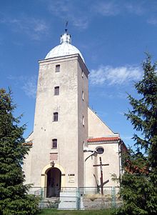
- Church (1641) in Mokre
- Church (1742) in Szynych
- Farm (19th century) in Dusocin
- Fort Wielka Księża Góra , German fort and bunkers (1890–1914) in the "Pfaffenberge" near Wielkie Lniska
Parks
- former park of the manor in Węgrowo
- former park of the manor in Wielkie Lniska
traffic
There are two airfields on the territory of the rural municipality :
- Lotnisko Grudziądz-Lisie Kąty ( ICAO code : EPGI), with a 950 m lane
- Lądowisko Wielkie Lniska , a special private airfield .
Personalities
- Ludwik Rydygier (also Riediger or von Ruediger ) (1850–1920), surgeon, urologist and university professor, born in Dusocin
- Juliusz Zieliński (1881–1944), Polish teacher, victim of National Socialism, 1920 district chairman in Dusocin.
Web links
Individual evidence
- ↑ population. Size and Structure by Territorial Division. As of June 30, 2019. Główny Urząd Statystyczny (GUS) (PDF files; 0.99 MiB), accessed December 24, 2019 .


