
Hintersee (Western Pomerania)
| coat of arms | Germany map | |
|---|---|---|

|
Coordinates: 53 ° 38 ' N , 14 ° 16' E |
|
| Basic data | ||
| State : | Mecklenburg-Western Pomerania | |
| County : | Vorpommern-Greifswald | |
| Office : | At the Szczecin Lagoon | |
| Height : | 14 m above sea level NHN | |
| Area : | 44.42 km 2 | |
| Residents: | 320 (Dec. 31, 2019) | |
| Population density : | 7 inhabitants per km 2 | |
| Postal code : | 17375 | |
| Area code : | 039776 | |
| License plate : | VG, ANK, GW, PW, SBG, UEM, WLG | |
| Community key : | 13 0 75 051 | |
| Office administration address: | Stettiner Strasse 1 17367 Eggesin |
|
| Website : | ||
| Mayoress : | Peggy clientele | |
| Location of the Hintersee community in the Vorpommern-Greifswald district | ||
 _in_VG.svg) |
||

Hintersee is a municipality in the district of Vorpommern-Greifswald in Mecklenburg-Vorpommern on the German-Polish border. It is administered by the Am Stettiner Haff office based in Eggesin .
geography


Hintersee is located in the far east of Western Pomerania . With behind the lake is the (drained) former Ahlbecker lake - today the nature reserve lake floor - meant. In the middle of the Ueckermünder Heide , Hintersee is surrounded by a forest and water-rich landscape. It is nine kilometers to the Stettiner Haff. The next town (Eggesin) is 15 km away, the town of Pasewalk 22 km. To the north of the municipality are the Neuwarper See and the Stettiner Haff , to the east the Große Mützelburger See . Due to its fen landscape , the area has a diverse flora and fauna.
Hintersee is surrounded by the neighboring communities of Luckow in the north, Nowe Warpno in the east, Blankensee in the south, Rothenklempenow in the south-west, Eggesin in the west and Ahlbeck in the north-west.
The Zopfenbeck district belongs to Hintersee .
history
In the area of the Ueckermünder Heide tar was burned and charcoal smoldered in the 17th century . The starting point for the development of the Hintersee was today's district of Zopfenbeck, where coal mining was still operated until 1940. This place was created in 1743 as a colony on the south bank of what was then Ahlbeck Lake. With the drainage of further swamp areas and the draining of the lake into the Randow and via the Teufelsgraben into the Neuwarper See, the long village of Hintersee slowly emerged. The residents traditionally lived from wood processing and agriculture. At the beginning of the 20th century, the economy in Hintersee developed with the connection to the railway network - a sawmill and a dairy were built. A sports club was founded, the 1906 "Frisch Auf" cycling club. Today some half-timbered houses herald this early days .
Around 1930, the district of Hintersee had an area of 3.9 km², and there were a total of 130 houses in four different places of residence in the municipality:
- Forsthaus Entepöl (today in Polish Dobieszczyn )
- Forsthaus Zopfenbeck
- Hintersee
- Riether Neuhaus
In 1925 the community of Hintersee had 850 inhabitants who were spread over 217 households.
When the border was drawn in 1945, the Stettin – Neuwarp railway ran partly on the Polish and partly on the German side. The German part was brought to the Soviet Union as reparation .
The population has been declining since 1990 - as in Western Pomerania as a whole.
Until 1945, Forsthaus Entepöl also belonged to the Hintersee community. After the Second World War , forester's house Entepöl was located on Polish territory and was renamed Dobieszczyn .
Development of the population
- 1862: 816, including one Catholic and five Jews
- 1925: 850, including three Catholics
- 2011: 353
politics
Coat of arms, flag, official seal
The municipality has no officially approved national emblem, neither a coat of arms nor a flag . The official seal is the small state seal with the coat of arms of the region of Western Pomerania . It shows an erect griffin with a raised tail and the inscription "GEMEINDE HINTERSEE".
Economy and Infrastructure
Established businesses
The companies located today include a construction business, a building and copper plumbing shop, a haulage company, a company for sanitary technology and heating construction, a joinery and the Seegrund estate.
Culture and sights
→ See: List of architectural monuments in Hintersee (Western Pomerania)
- In the Ueckermünder Heide near the village on the road from Ueckermünde to Stettin there is the so-called Barnim Cross and a memorial stone. The two monuments stand at the point where Barnim II is said to have been stabbed to death by the knight Vidanz Muckerwitz from Vogelsang, according to legend in 1295 .
- On the hiking trail in Ludwigshof along the former railway line, wooden sculptures were set up, which were presented at a wood sculptor symposium organized by the Vorpommern-Ueckermünde e. V. originated.
- The painter and graphic artist Klaus Parche ran a gallery in Hintersee until 2007. Today his pictures can be seen in Ueckermünde. The old gallery is now privately inhabited.
- In the local sports club "Frisch Auf" 1906 Hintersee e. V. , among other things, artistic cycling, volleyball, cycling and bowling are on the program.
- The traditional Hinterseer Volkssportfest at Whitsun (including the individual time trial over approx. 17 km on Whit Monday) is a sporting highlight in the region with numerous participants.

Wooden cross at the site of the presumed killing of Duke Barnim II. 1295
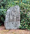
Memorial stone for the 500th anniversary in the same place


Village church
The St. Johanneskirche in Hintersee was completed in 1899. Before that, there was an old half-timbered barn on the building site, which was provided with rollers and moved - a remarkable process at the time. The barn is still standing today. The church is a neo-Gothic building with a slender tower. Renovation work was carried out in 1985 and 1990 (choir room, copper roof).
Transport links
Coming from the west, you drive via Eggesin or Ueckermünde - Luckow, Ahlbeck and Gegensee. The northern route via Ludwigshof is cobblestone. The road from the south (from Löcknitz ), which from Rothenklempenow at the beginning of the 1990s, similar to the Ludwigshofer route, consisted of a mixture of sand, cobblestones and large potholes, has now also been rebuilt with the through-roads (2013) in Grünhof and Glashütte. At the same time, a road-side cycle path was created to Grünhof. The city center of Szczecin ( Stettin ) can be reached in 30 minutes via Tanowo ( Falkenwalde ) via the car border crossing from Hintersee (L 28) to Dobieszczyn ( Forsthaus Entepöl ) on the Polish side, which was laid out in 1992 and opened in June 2008 . This route is also served by a public bus line.
See also
Web links
Individual evidence
- ↑ Statistisches Amt MV - population status of the districts, offices and municipalities 2019 (XLS file) (official population figures in the update of the 2011 census) ( help ).
- ↑ a b c Gunthard Stübs and Pomeranian Research Association: The Hintersee community in the former Ueckermünde district in Pomerania (2011).
- ^ Heinrich Berghaus : Land book of the Duchy of Pomerania and the Principality of Rügen . Part II, Volume 1, Anklam 1865, pp. 1070-1071
- ↑ Main Statute, Section 1, Paragraph 2 (PDF).
- ↑ Ludwig Wilhelm Brüggemann : Detailed description of the current state of the Königl. Prussian Duchies of Western and Eastern Pomerania . Part I: General introduction and description of the Prussian Western Pomerania , Stettin 1779, p. 41, no. (5) b.
- ^ The Barnim Cross ( Memento from September 4, 2012 in the Internet Archive )
Ahlbeck | Old Tellin | Altwarp | Altwigshagen | Anklam | Bandelin | Bargischow | Behrenhoff | Bentzin | Benz | Mountain wood | Blankensee | Blesewitz | Boldekow | Boock | Brietzig | Brünzow | Bugewitz | Buggenhagen | Butzow | Daberkow | Dargelin | Dargen | Dersekow | Ducherow | Eggesin | Fahrwalde | Ferdinandshof | Garz | Glazov | Görmin | Grambin | Grambov | Greifswald | Gribow | Gross Kiesow | Groß Luckow | Great Polzin | Gützkow | Hammer ad Uecker | Hanshagen | Heinrichswalde | Heringsdorf | Hinrichshagen | Hintersee | Iven | Jarmen | Jatznick | Comb teeth | Karlsburg | Karlshagen | Katzow | Kemnitz | Klein Bünzow | Koblentz | Korswandt | Koserow | Krackow | Krien | Kröslin | Kruckow | Krugsdorf | Krummin | Krusenfelde | Lassan | Leopoldshagen | Levenhagen | Liepgarten | Löcknitz | Loddin | Loissin | Loitz | Lubmin | Luebs | Luckow | Luetow | Medow | Meiersberg | Mellenthin | Mesekenhagen | Mölschow | Mönkebude | Murchin | Nadrensee | Neetzow-Liepen | New Boltenhagen | New Kosenow | Neuenkirchen | Neuenkirchen | Low | Papendorf | Pasewalk | Peenemünde | Penkun | Plow | Polzow | Postlow | Pudagla | Ramin | Rankwitz | Rollwitz | Rossin | Rossow | Rothemühl | Rothenklempenow | Rubenov | Rubkov | Sarnow | Sassen-Trantow | Sauzin | Schmatzin | Schönwalde | Spantekow | Stumble on the Peene | Stolpe on Usedom | Strasburg (Uckermark) | Torgelow | Trassenheide | Tutow | Ückeritz | Ueckermünde | Usedom | Square | Vogelsang-Warsin | Völschow | Wackerow | Weitenhagen | Wilhelmsburg | Wolgast | Wrangelsburg | Wusterhusen | Zemitz | Zempin | Zerrenthin | Ziethen | Zinnowitz | Zirchow | Züssow