Gmina Nowe Warpno
| Gmina Nowe Warpno | ||
|---|---|---|

|
|
|
| Basic data | ||
| State : | Poland | |
| Voivodeship : | West Pomerania | |
| Powiat : | Policy | |
| Geographic location : | 53 ° 43 ' N , 14 ° 16' E | |
| Residents : | 1190 (June 30, 2019) |
|
| Postal code : | 72-022 | |
| Telephone code : | (+48) 91 | |
| License plate : | ZPL | |
| Economy and Transport | ||
| Street : | Ext. 114 : Tanowo- Nowe Warpno | |
| Ext. 115 : Stettin- Nowe Warpno | ||
| Rail route : | PKP line 406: Szczecin ↔ Trzebież , train station: Trzebież Szczeciński | |
| Next international airport : | Szczecin-Goleniów | |
| Gmina | ||
| Gminatype: | Urban and rural municipality | |
| Gmina structure: | 6 localities | |
| 2 school offices | ||
| Surface: | 197.88 km² | |
| Residents: | 1654 (June 30, 2019) |
|
| Population density : | 8 inhabitants / km² | |
| Community number ( GUS ): | 3211033 | |
| Administration (as of 2006) | ||
| Mayor : | Wladyslaw Piotr Kiraga | |
| Address: | pl. Zwycięstwa 1 72-022 Nowe Warpno |
|
| Website : | www.police.pl | |
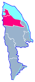
The Gmina Nowe Warpno is an urban and rural municipality in the West Pomeranian Voivodeship in Poland . It belongs to the Powiat Policki and covers an area of 197.88 km² with over 1,600 inhabitants. In the south-east the urban and rural community borders on the Gmina Police , in the north on the Stettiner Haff and in the west the urban and rural community borders on Germany .
The following localities belong to the municipality:
|
|
|
Web links
Commons : Gmina Nowe Warpno - album with pictures, videos and audio files
Footnotes
- ↑ a b population. Size and Structure by Territorial Division. As of June 30, 2019. Główny Urząd Statystyczny (GUS) (PDF files; 0.99 MiB), accessed December 24, 2019 .


